The exact date of this panoramic photograph is uncertain. When originally loaded into the University’s Flickr site, the photo was ascribed a date of June 1896. This was clearly wrong, as both the General Roberts Hotel and the Sportsmans’ Arms Hotel can be seen, both of which were built in 1903.
General Roberts HotelSportsmans Arms Hotel
Robert Watson suggests that the photographs may have been in a box “marked as June’06, and the transcriber has misread Snowball’s handwriting as June ’96.” Can we confirm that date or get firm evidence for a date range?
The evidence of the Commonwealth Hall
Commonwealth Hall, in Hobart Road. 1903-1912.
In the photograph, to the right of the Sportsmans’ Arms Hotel we see the Commonwealth Hall. This was erected in 1903 by the licensee of the Sportsmans’ Arms. The hall building was subsequently sold, dismantled and moved to Belmont sometime between July 1912 and December 1913. Thus the date of panorama is unambiguously somewhere in the range 1903 to 1913.
The evidence of the Tauranga trees
In March 1909 New Lambton Council “recommended that a row of trees be planted on the east side of Taurangua road, from the intersection of Lambton road to Hobart-road”, and in June 1909 the Mayor reported that “the tree planting in Taurangua-road had been completed, and the park fence had been repaired.” As there is no sign of these trees in the photograph, it strongly suggests the photo was taken before June 1909.
The evidence of the shelter shed
In October 1903 the parks committee of the New Lambton Council recommended “that the council clerk obtain specification and cost of a shelter shed to be erected in the park, 24 x 12, with moveable front awning (2) that the shed be erected between the 5th and 6th tree guards.” At their meeting on 18 November 1903 the council resolved “that the tender of W. Knight be accepted for the erection of a shed in the park for the sum of £31, including labour and material.” The shed had been constructed and in use by the cricket club by August 1904. Snowball’s photograph shows the shed between the 5th and 6th tree guard, so the photo must date from after November 1903 when the tender for construction was accepted.
The evidence of the park tree guards
In a July 1907 meeting of New Lambton council …
The Mayor reported that the work of erecting tree guards in the park had been commenced. Sufficient timber had been ordered to complete 27 guards, 17 of which would be erected in park No. 1 and 10 in park No. 2.
Newcastle Morning Herald and Miners’ Advocate, 25 July 1907.
No. 1 Park is Harker Oval today, and No. 2 Park is Regent Park today. We know from the erection of the shelter shed that some tree guards were at the park in 1903, so the 17 guards for No.1 Park mentioned in the 1907 council meeting are additional guards. Snowball’s panorama photo shows a number of tree guards along Hobart Rd whose whiteness indicates they are fairly new, thus suggesting the panorama dates from not long after July 1907.
Conclusion
Based on the evidence above I conclude that the panorama photo is definitely in the range July 1903 to December 1913, almost certainly in the range December 1903 to June 1909, and probably in the range July 1907 to June 1909.
I recently became aware of an 1886 subdivision map of New Lambton, held in the State Library of NSW archives. One of the interesting aspects of this map is that it shows details of lot leases.
1886 New Lambton subdivision map showing leased lots shaded with cross-hatching. State Library of NSW.
This is important because when the colliery opened in New Lambton in 1868, the coal company only leased their land, and did not start selling land until 1886 after their coal operations there had ceased. This is in contrast to the neighbouring Lambton Colliery, who from their very beginning in 1864 sold land in the Lambton township to miners. So unlike Lambton where it is possible to inspect land title records in the Historical Land Records Viewer to determine who lived where, in New Lambton prior to 1886 determining who occupied what land is much more difficult.
Inspecting the 1886 subdivision map gives a snapshot of land occupation in that year, and in particular throws light on this previously undated Ralph Snowball photograph in the Living Histories site, captioned as “Unidentified family, New Lambton”.
Looking at lots 34-39 in Section S and lots 10-14 in Section Z, we see a roughly rectangular area of land marked as Horsfield’s Lease.
Noting three other leases on the map – Lucas’ Lease in Section S, Gould’s Lease in Section R, and the Wesleyan Church in Section J – we see that these align with the buildings we see in Snowball’s photograph.
In the 1886 map the dividing line between the northern and southern lots in Section S is shown as a straight line. This is where the gully/creek runs down the hill between Addison Rd and St James Rd. This is made clearer in a later 1901 subdivision map, where the line of the creek has been added. The Snowball photograph matches the map, as we see a creek running along the northern border of Horsfield’s lease.
Having established that Snowball’s photo is probably of Horsfield’s Lease, a search of Trove provides confirmation in this 1883 advertisement for the sale of William Horsfield’s Leasehold property.
Advertisement for the sale of William Horsfield’s Leasehold property at New Lambton. Newcastle Morning Herald and Miners’ Advocate, 29 September 1883.
We see in Snowball’s photograph the two houses mentioned in the advertisement – the smaller two room house and the larger 5 room house, and a garden between the houses and shed. If you look really closely you can even see one cow in the fenced paddock.
The 1883 advertisement is for 6 acres of land, and notes that it “will be sold in one lot or subdivided.” In the 1886 map the area marked as Horsfield’s measures only 3.5 acres, which suggests that in 1883 only 2.5 acres of leasehold land was sold.
Google Earth view showing the location of Horsfield’ Lease in New Lambton.Google Earth oblique view showing the location of Horsfield’ Lease in New Lambton.Approximate location of the Horsfield’s Lease photo, St James Rd, New Lambton, March 2025.
Dating the photograph
In the photo there is no sign of any of the streets in that area having been made yet. In particular the Portland Place road near the Wesleyan Church is not visible. We know that section of road existed in 1896 as New Lambton council voted …
That Portland-place from the New Lambton estate boundary to Cromwell-street be gravelled 21ft wide, at a cost of £25
As Snowball’s photographic career started in 1885, this places the Horsfield Lease photo in the definite range 1885 to 1896.
After New Lambton council formed in 1889 they quickly set about making and improving roads, and thus needed a good supply of gravel. In 1890 they opened up a quarry near Hincks lease at the top of Addison Rd and arranged for the construction of a tramway to carry the gravel 400 yards down the hill. In Snowball’s Horsfield’s lease photo there is no sign of either a roadway to the quarry or a tramway, indicating that the photo is probably before 1890.
Also, a close examination of the buildings in the photo shows that almost all seem to be located on blocks of land marked as leases on the 1886 map. Land sales in this area only commenced in March 1886, and assuming that people would start building houses on their land soon after purchase, this suggests the photo can’t be too many years after 1886.
In conclusion, my best guess for the date of the photo is within the range 1885 to 1890.
Navigating the real estate market today can be a battle, but it’s unlikely to be as dangerous as the New Lambton land sale of 1886. The colliery in this area was established in 1868, with land leased to miners rather than sold outright. After the mine closed, the owners planned a 474-lot subdivision, to be auctioned on-site on 27 February 1886. To entice bidders, a free special train from Newcastle was laid on, and lunch was to be provided. Things did not go well. The Newcastle Morning Herald and Miners’ Advocate reported:
One of the most disorderly scenes ever witnessed in the county occurred at New Lambton on Saturday, when Mr. J. C. Bonarius, the well-known and popular auctioneer, endeavoured to sell the property known as the New Lambton Estate. This land has been occupied for the past 16 or 17 years by tenants who have erected houses, and having lived so long on the land, resent any attempt to dispossess them. Accordingly, as soon as the train arrived, it was met by a hooting, roaring crowd, composed of the old leaseholders shouting, “They’re going to sell the roof over our heads!” On the sale being commenced, by their howling and groaning and making ridiculously small bids, they endeavoured to block the proceedings. The crowd then broke into the luncheon tent, seized the provisions and liquors, and threw the furniture outside. Five different messengers were despatched for the police, but none could be found, they all being away at the Wallsend races. The meeting had become a complete riotous display, and a number of intending buyers were intimidated and threatened. Mr. Bonarius had nothing left but to withdraw the sale.
Newcastle Morning Herald and Miners’ Advocate, 1 March 1886.
In the aftermath of the riot another on-site auction was not attempted. Instead, a month later Mr Bonarius held an auction in the Victoria Theatre in Newcastle – this time without food, without alcohol, and without incident.
A poster advertising the New Lambton Estate subdivision sale in 1886, which curiously has a completely different set of street names to those we know today. State Library of NSW.What might have been – Pitt St and Horsfield St in New Lambton, now Portland St and Regent St. (Image digitally altered.)
The article above was first published in the March 2023 edition of The Local.
Additional Information
The original land sale was heavily promoted by J C Bonarius in the lead up to the on-site auction, with multiple large advertisements in the newspaper. The proprietor of the newspaper also got on board, with more than one editorial ‘puff piece’ praising the impending land sale in glowing terms such as “fine subdivision”, “best land”, “beautiful building sites”, “a more lovely spot is not to be found”, “the beauties of New Lambton Heights are far beyond description”, and “this little paradise”.
For reasons of space, the newspaper report I quoted in the article published in The Local was a much condensed version of the original, which appears in full below.
RIOT AT LAMBTON. The Mob Block a Land Sale. Disgraceful Proceedings.
ONE of the most disorderly scenes ever witnessed in the county of Northumberland occurred at New Lambton on Saturday last, when, pursuant to advertisement, Mr. J. C. Bonarius, the well-known and popular auctioneer, endeavoured to sell the property known as the New Lambton Estate. The special train, which left here at noon, conveyed a large number of intending purchasers from Newcastle, and there were numerous visitors from Sydney, Maitland, and elsewhere.
It appears that this property has been occupied for the past 16 or 17 years by a number of tenants who have erected houses thereon, and who originally held leases of 14 years, which have expired, two or three years since, through effluxion of time. Hence, having lived so long on the land, the occupiers came to regard it as their own, and were prepared to resent any attempt to dispossess them of what they, from force of habit, had led themselves to believe to be their birth-right, forgetting that since the expiration of their leases they had been permitted to remain on the land on sufferance rent free.
Accordingly, as soon as the train arrived, it was met by a hooting, roaring crowd, composed of the old leaseholders and their patizans, and a number of those who are always in their glory when there is a prospect of a row, shouting “They’re going to sell the roof over our heads !” Taking no notice, the party proceeded to partake of luncheon in a tent prepared for the occasion. During this time the larrikin element began to manifest itself in various way, and Mr. Bonarius, the auctioneer, addressed the crowd, which number in all about 700 persons, asking them in the most persuasive terms to keep quiet; but without avail. On the sale being commenced, it was evident that a concerted plan had been adopted by the old leaseholders to block it. Drafts of them were distributed here and there among the mob, and by their howling and groaning and making ridiculously small bids, they endeavoured to achieve this object. The crowd then broke into the [lunch] tent and took whatever they could lay their hands on, seized the provisions and liquors and threw the articles of furniture outside. The Hon. G. R. Dibbs, Colonial Secretary, who was present, remonstrated with them, asking them to conduct themselves like men, but they took no heed, and Mr. Dibbs and a number of gentlemen had to withdraw to save themselves from violence. Mr. Bonarius and his son were also threatened, and the attendants in charge of the luncheon paraphernalia beaten and ill-used. Five different messengers were despatched for the police, but none could be found, they all being away at the Wallsend races – which fact the mobs well knew. The meeting had now become a complete riotous display; the auctioneer’s voice was inaudible amidst the babel of tongues, and a number of intending buyers who were present were intimidated from bidding, as the rioters threatened them with ill-treatment if they did so. Mr. Bonarius had nothing left but to withdraw the sale, on which announcement being made, the mob set up cheer after cheer that could be heard a mile off. Lots 1 and 2, section B, on the crown of the hill, were sold at £2 per foot, while a few blocks lower down realised from 15s to £1 per foot.
It may be mentioned that last week Mr. Bonarius valued the allotments, informing their occupants that he would not sell the lots on which houses were built if the tenants were willing to pay the same for them as the adjoining allotment fetched. All except three were satisfied with his valuation, from which the proprietors were willing to knock off 50 per cent., and also to give two large allotments to each of the churches for the erection of their respective places of worship, and two allotments for a Mechanics’ Institute.
We understand that Police Court action is to be taken against the ringleaders.
Newcastle Morning Herald and Miners’ Advocate, 1 March 1886.
A fortnight later, one of the leaseholders on the New Lambton estate wrote a letter to the editor, giving quite a different explanation of the disturbance.
Sir, – Seeing an account in your paper of Monday, March 1st, wherein one of the most disorderly scenes ever witnessed in the county of Northumberland occurred at New Lambton, there being so many misstatement I deem it my duty to correct. First, the train arrived at New Lambton with 25 passengers, including vendors, auctioneers, and others. True, Sir, we have lived on the estate for 16 or 17 years, and have held leases for 14 years, but after that term expired we went on the same as before, paying our 30s a year for each allotment. As our original leases stated we had the right of renewal, and the proprietors have held out promises to renew it, so you will see, Sir, we have not, been living there rent free. Next, the train arrived and was “met by a hooting, roaring crowd, composed ofleaseholders, &c.” We give our most emphatic denial to this. The people got out of the train and were never molested. After arriving on the top of the hill and partaking of luncheon provided by the auctioneer, some of the liquid portion was not long before it commenced to operate on the larrikin element, which had come from all parts of the district; and I have no doubt that they did misbehave themselves, and for this we blame other people, and not the tenants of the New Lambton Estate. As for 700 people being there, I think if the writer had said 70 it would have been nearer the mark. Now, Sir, I say we had no concerted plan adopted to block the sale, but it was the auctioneer who ran the land up to such an exorbitant price that the leaseholders knew they had no chance to buy the small piece of land their houses stood on, which was believed not to be a bona fide bid after all. The Hon. G. R. Dibbs was also present, and remonstrated with children and larrikins for their bad behaviour. Now, Sir, if I were the father of one of those children who got intoxicated I would most undoubtedly have seen further into it. As for Mr. Dibbs and other gentlemen having to withdraw to save themselves from violence, they did not leave until after the sale was closed. Also as to Mr. Bonarius and his son being threatened and the attendants in charge of the luncheon paraphernalia beaten and ill used, we know of no one being ill used; but this we know, a young man stood on the counter, with a bottle of porter in his hand, threatening to knock down the first man that touched anything, but he was besieged by the larrikins and the bottle taken from him. And as for the police, I think it was the man’s fault who brought so much liquor. He should have seen that it was properly protected. Next comes: “Mr. Bonarius’s voice being inaudible with the babel of tongues.” This noise proceeded from the larrikin element, who were by this time intoxicated and quarrelling among themselves. The “intending buyers being intimidated by the leaseholders” we deny in toto. As for cheering taking place after the sale was closed, we heard none, and if there had been we would have heard it. True, Sir, lots Nos. 1 and 2 on the top of the hill were knocked down at £2 per foot, that being the only legitimate sale that took place that day, the others being a farce. It is true Mr. Bonarius was up last week and valued the houses on the allotments, not the allotments, Sir, and for which we had agreed to pay 50 per cent. of the said valuation, provided we became purchasers of the land, for which we had to pay the same as the next allotment to us brought. Hoping you will pardon me for trespassing,-I am, &c., ONE OF THE NEW LAMBTON TENANTS.
Newcastle Morning Herald and Miners’ Advocate, 13 March 1886
Some of this letter stretches credulity to breaking point, as the writer successively blames the riot on …
“the larrikin element, which had come from all parts of the district”
“other people”
“the auctioneer who ran the land up to such an exorbitant price”
“children and larrikins”
“children who got intoxicated”
“the man’s fault who brought so much liquor”
… while all the time denying that the leaseholders, who clearly had the most to gain from blocking the sale, bore any responsibility at all.
The truth probably lies somewhere between the Herald’s sensationalistic report of 1 March 1886 and the leaseholder’s exculpatory letter of 13 March 1886. However it is clear that whatever occurred on Saturday 27 February 1886, it was sufficiently disruptive to cause the abandonment of the sale after only 2 lots had been auctioned.
The 1886 subdivision map
One of the important aspects of the 1886 subdivision map is that it shows which lots were leased and to whom they were leased. For example, in Sections D and G we see leases to Lunn (James Lunn of the Hand of Friendship Hotel), Sneddan, Horsfield, and Butterworth (Abraham Butterworth of the Duke of Wellington Hotel.)
Lots 1 to 4 of Section G are shown as leased by “Sneddan”, a rather mercurial name with various other documents and newspaper articles spelling the name “Snedden”, “Sneddon”, and even “Snedding”. Mr Thomas Sneddon was a long-time resident and well known gardener and florist in New Lambton. A number of editorial puff pieces leading up to the February 1886 land sale made reference to his garden.
20 January 1886 – “A correspondent writes that having had occasion to transact business at Wallsend the other day, he started from Newcastle in a bus, and when near New Lambton a gentleman induced him to get out and visit Snedding Garden at New Lambton. To his utter astonishment he saw one of the prettiest gardens outside of Sydney. The whole place was a living mass of flowers of all kinds and colours, and the fernery was beautiful, some of the choicest kinds being New South Wales ferns.”
30 January 1886 – “The paragraph which appeared in your paper last week, referring to Snedding Garden, or this estate, and to the site equalling for scenery anything in this part of New South Wales, led me to take a journey to this northern paradise, and to my astonishment I was well paid for my labour. The ‘bus dropped me at the railway bridge, and I made my way to the gardens, which are really beautiful. Flowers and ferns are herein abundance, and to give you the names of them would take me too long, but the wonder to me was how they grow here in the open air in such splendour. I was informed the soil was very rich, and with a little trouble anything thing will grow at New Lambton Heights.”
20 February 1886 – “I visited some of the houses, and fortunately happened to drop into Mr. Sneddon’s garden. I was very glad of this, as I had read an account of this garden, and really was paid for my trouble. I was here surrounded by all the colours of the rainbow, and was not long in procuring a lovely bunch of flowers that really would have done credit to Covent Garden in the old country. The camelia bushes are just breaking out with their lovely new leaves, and when the season arrives New Lambton Heights will be able to show camelias with any part of New South Wales.”
Thomas Sneddon resided in New Lambton until his death in 1927, aged 83. His obituary described the fame of his garden.
Mr Thomas Sneddon who died last week at his home, cnr Cromwell and Victoria streets, was one of the oldest residents of New Lambton. He was known throughout the Newcastle and Maitland districts as a keen horticulturist, and his gardens proved a strong attraction. In past years, during the days of the old wind jammers, they were the rendezvous of ship captains and other visitors. Mr. Sneddon was born at Cockpen, county of Edinburgh in 1844. He came to New Lambton in 1879, when the township was but a scrub, and lived there till his death at the age of 83. As a flower exhibitor he won many prizes at various shows, and in certain classes he invariably swept the board. He had also acted as judge on many occasions. In his early years at New Lambton he conducted a grocery business on the corner of Regent and Victoria streets, eventually selling out, and taking up the florist business, which he conducted (with the aid of his family) to the present.
Newcastle Morning Herald and Miners’ Advocate, 13 April 1927.
1886 street names
1886 Street Name
Probably named after
Present Street Name
Bonarius St
John Charles Bonarius, auctioneer
Carrington Pde
Brown St
Alexander Brown, proprietor of New Lambton Coal Company
Cromwell St
Brummy St
Russell Rd
Coal St
Fleet St
Dibbs St
G.R. Dibbs, colonial secretary and part owner of the New Lambton Estate land.
Evescourt Rd
Griffin St
Victoria St
Hill St
Queens Rd
Mitchell St
James Mitchell, former owner of a 128 acre parcel of land whose northern border is on the line of Mitchell St.
Henley St
Pitt St
Portland Pl
Horsfield St
Thomas Horsfield, former manager of the New Lambton colliery.
Regent St
Short St
Baker St/Curzon Rd
Soudan St
Addison Rd
Thomas St
James Thomas, manager of New Lambton colliery.
Oxford St
William St
High St
Young St
St James Rd
There are scant references to the original street names in the newspaper …
Griffin St is mentioned in 1875 and in an 1879 reference to the Duckenfield Hotel.
Horsfield St is mentioned in reference to the Duke of Wellington Hotel – Abraham Butterworth licensee in 1878, and Thomas Pringle licensee in 1879.
I have found no information as to why the original street names was abandoned, and a new set of names adopted. The modern street names first started appearing in newspaper reports in 1889, the year that New Lambton municipal council was formed.
Curiously, the part of New Lambton north of Russell Rd also originally had a set of street names different from the current names, although in this case we know this was due to an administrative bungle.
The ‘missing’ lot
The map promotes the subdivision as “containing 474 blocks of land”.
The subdivision contains 25 sections, labelled ‘A’ to ‘Z’ (omitting section ‘I’), with each block of land labelled with a number. On tabulating the numbered lots in each section, I initially came up with a total of only 473 lots. I eventually found what I think is the answer to this discrepancy, where in Section S lot 22 is divided in half and leased to two different persons.
Later land titles show the southern half of this block labelled as Lot 22A.
Fifteen years after the aborted on-site auction of 1886, the proprietors felt brave enough to attempt another on-site auction of the remaining lots, on Saturday 20 April 1901. I have no explanation of why the advertisement says there are 325 allotments available while the poster map shows only 312 lots for sale.
Advertisement for 20 April 1901 auction sale of New Lambton Estate. Newcastle Morning Herald and Miners’ Advocate, 20 April 1901.
The map only has 213 lots that are not marked as sold, so is clearly after 1901 when there were more than 300 lots for sale. Inspecting the land sales on Vol-Fol 1865-121, pages 6 and 7 shows that Lot 9 Section F sold on 15 April 1913 and is marked as sold on the above map. The next entry on Vol-Fol 1865-121, Lot 15 Section J sold on 19 June 1913 and is NOT marked as sold on the map. All subsequent entries on Vol-Fol 1865-121 are likewise not shown as sold on the map, thus dating it to mid 1913.
There does not appear to have been a big advertised sale of land in New Lambton in 1913 associated with this map, however a 9 September 1913 article refers to progress in constructing the “Eves Court” bridge and notes that …
The bridge will have the effect of opening up a considerable portion of land on what is generally termed “The Second Hill,” to the right of Orchardtown, and this land will probably be the second subdivision of the New Lambton Coal Company.
The bridge was of sufficient importance to the New Lambton Company in their real estate ambitions, that they contributed £115 of the eventual £234 construction cost. It is probable that the 1913 subdivision map was produced to facilitate and promote land sales expected to arise from the construction of the Evescourt Rd bridge. A social function to celebrate the opening of the bridge was held at Butterworth’s hotel on 13 December 1913.
"Mr. W. H. Bonney has just completed a plan for Messrs. Hodgkinson and Wilkinson, of Newcastle and Maitland, which does him great credit. The plan is 11 feet, long, by 5 feet wide and shows all the blocks of land - 474 building sites, at New Lambton - which are to be sold on the 27th instant by Mr. J. C. Bonarius, auctioneer. The colouring is very good, and the plan altogether is one of the neatest we have seen. It is to be on view at the Borough Markets."
"Attention is drawn to the great land sale of "The heights of New 'Lambton," which is to be held in the Victoria Theatre to-morrow at 12 o'clock. Mr. J. C. Bonarius is the auctioneer. The property consists of over 158 acres of freehold land, subdivided into lots to suit all classes. As it is within a quarter of an hour's drive of the city, and adjoins the proposed tramway, it is most conveniently situated. Healthy and elevated, this most valuable subdivision should meet with keen competition."
"Purchasers of allotments of land on the New Lambton Estate are reminded that promissory notes for the second payment, due on 1st September next, are payable at the Commercial Bank, Newcastle."
This list covers hotels that were located in the area of New Lambton Municipal Council (1889-1938), shown by the white border in the image below. The current suburb of New Lambton is shaded in yellow. Note that the northernmost tip of the New Lambton municipality included a small part of present day Broadmeadow, which is why the Sunnyside Hotel is included in this page of New Lambton hotels.
Area of New Lambton Municipality (1889-1938) bordered in white, with present day suburb of New Lambton shaded with yellow.
The map below shows the location of Lambton Hotels. The four hotels that are still operating are shown in green, historical hotels are shown in red.
Timeline of New Lambton Hotels.
In documenting the history of hotels it is important to understand the roles of owners, lessees and licensees. The hotel owner is the person (or company) that owns the land and buildings upon the land. The owner may then lease the buildings to another person (or company) for the purpose of running a business such as a hotel. The hotel licensee is the person who is granted a liquor license by the government and is responsible for adhering to the liquor regulations. Sometimes the owner and licensee are the same person, but sometimes the owner, lessee and licensee are three different entities. For example, in 1878 for the New Lambton Hotel, the land was owned by the New Lambton Company, leased to Joseph Chinchen, and the hotel licensee was Enoch Davies.
The history of hotels can also be confusing in that the same hotel can have different names over time. For example, the Kotara Hotel was renamed to the Blackbutt Hotel in 1978. Sometimes a hotel name and license can be transferred to a different geographical location. For example, the Sportsman’s Arms Hotel first opened on Regent Street in 1870, but then moved to Hobart Road in 1903.
A further complication is the variant spellings of the licensee names. Where there are multiple spellings of a name and the correct spelling is uncertain, I have included variant spellings in square brackets. e.g. “Damerell [Damerill]”. Note that in the lists of licensees I have only included names up to about 1970, as online information about licensees after this date becomes sparse.
In the list below I have an entry for each hotel operating at a specific location. The hotels appear in order of the year they were first opened.
New Lambton Hotel (1869-1879)
The first hotel in New Lambton was the somewhat unimaginatively named “New Lambton Hotel”. It was erected on the south-west corner of Russell Rd and Regent St by Mr Hubbard of Hunter St Newcastle.
On our way home from the foot races, at Lambton, on Saturday last, we had an opportunity of paying a visit to the New Lambton Hotel, recently erected by Mr. Hubbard, of Hunter-Street. The building in question is certainly an excellent one, and, in every way, well adapted to the requirements of the place. The expeditious manner in which this hotel was put up is worthy, of notice. Less than four months ago, from the present time, the ground on which it stands was a wild, uncleared bush ; and the hotel has been open for nearly a month, so that, as a matter of fact, the hotel was only three months in course of erection. Of course this would be nothing out of the way if the site had been an accessible one — which it was not — the road to New Lambton being about as bad a one as there is in the whole district, and that is saying a good deal. The building is a two-story one, and appears to be well and faithfully built. It is nicely painted inside and out, and is really a very snug and comfortable place. The bar is commodious and airy, and in regard to attractiveness is not surpassed by any establishment in the city of Newcastle. On the upper floor of the hotel there is a large room, well adapted for public meetings and entertainments, and at the rear of the premises are stables to accommodate an almost unlimited number of horses. Altogether, the New Lambton Hotel is one of the very best hotels in any of the colliery townships.
Henry Lott, the first licensee of the hotel, was granted a publican’s licence in July 1869. His tenure at the hotel did not last long, only 9 months later in March 1870, the lessees (Hubbard and Chinchen) advertised for sale, the “license, stock, and furniture of the New Lambton Hotel.”
In May 1870 John Gordon announced in a large advertisement that he had taken on the New Lambton Hotel. His tenure was similarly short-lived and by March 1871 Hubbard and Chinchen were once again advertising the hotel for letting.
David Lewis was issued a publican’s licence commencing on 1 July 1871, followed by George Lowe who held the licence from 1 July 1874. In May 1875 George Lowe advertised “a sale by auction for household furniture and effects” at the New Lambton Hotel.
Thomas Hardy was issued the publican’s licence from 1 July 1875. In December 1876 the hotel had a narrow escape from being burned down, when a hanging kerosene lamp, without any apparent cause, suddenly exploded and splashed burning oil on the floor. Only the quick action of Thomas Hardy’s daughter in smothering the flames with a blanket prevented a serious conflagration.
In April 1877 the newspaper reported that the hotel was “about to change hands from Mr T Hardy to Mr Enoch Davies”. At a Police Court hearing in June 1880 “the license of the New Lambton Hotel, New Lambton, was cancelled, as the proprietor, Mr. Enoch Davis, was proved to have abandoned his licensed house.”
There is a final reference to the hotel on 15 October 1880, with an advertisement noting that “Mr T M Dalveen will address the electors … at the New Lambton Hotel”. As there is no evidence of any licensees after Enoch Davies cancellation, I can only assume that this is a reference to the hotel building, not the hotel as a licensed premises.
An article in September 1892 states that after the hotel was no longer licenced, the building was “used as a store and temperance hall.” Mentions of a Temperance Hall in New Lambton start appearing in Trove from September 1880, just a few months after the licence was removed.
There are no known photographs of the original hotel and Temperance Hall building, and the date of demolition is uncertain. The brick building that now occupies the site appears to be 1920s era.
Site of the New Lambton Hotel (1869-1880) in March 2025,
Location
An 1877 map relating to the proposed site for New Lambton public school shows the New Lambton Hotel on the south-west corner of Russell Rd and Regent St.
Map reproduced from the New Lambton Public School (1880-1980) Centenary booklet.
The following information, also supports this location.
16 September 1869 article says it was “within a few yards” of Lunn’s Hand of Friendship Hotel south-east corner of Russell Rd and Regent St)
16 April 1878 advertisement for lease of New Lambton Hotel, applications to J Chinchen. An 1886 New Lambton Subdivision map shows that Lots 5 and 6 were leased to “Chinchin”, and Land Title Vol-Fol 1048-80 shows Lot 5 of Sec C passed into Ellen Chinchen’s ownership in 1892.
21 April 1951 article mentions “Lathlean’s Temperance Hall, a building on the corner of Russell and Regent Streets that had been a hotel.” Land Title record Vol-Fol 1048-80 shows Lot 5 of Sec C was owned by Richard Lathlean from 1892 to 1907.
1886 subdivision map showing Chinchin’s [sic] lease in Section C and Lunn’s lease in Section D.
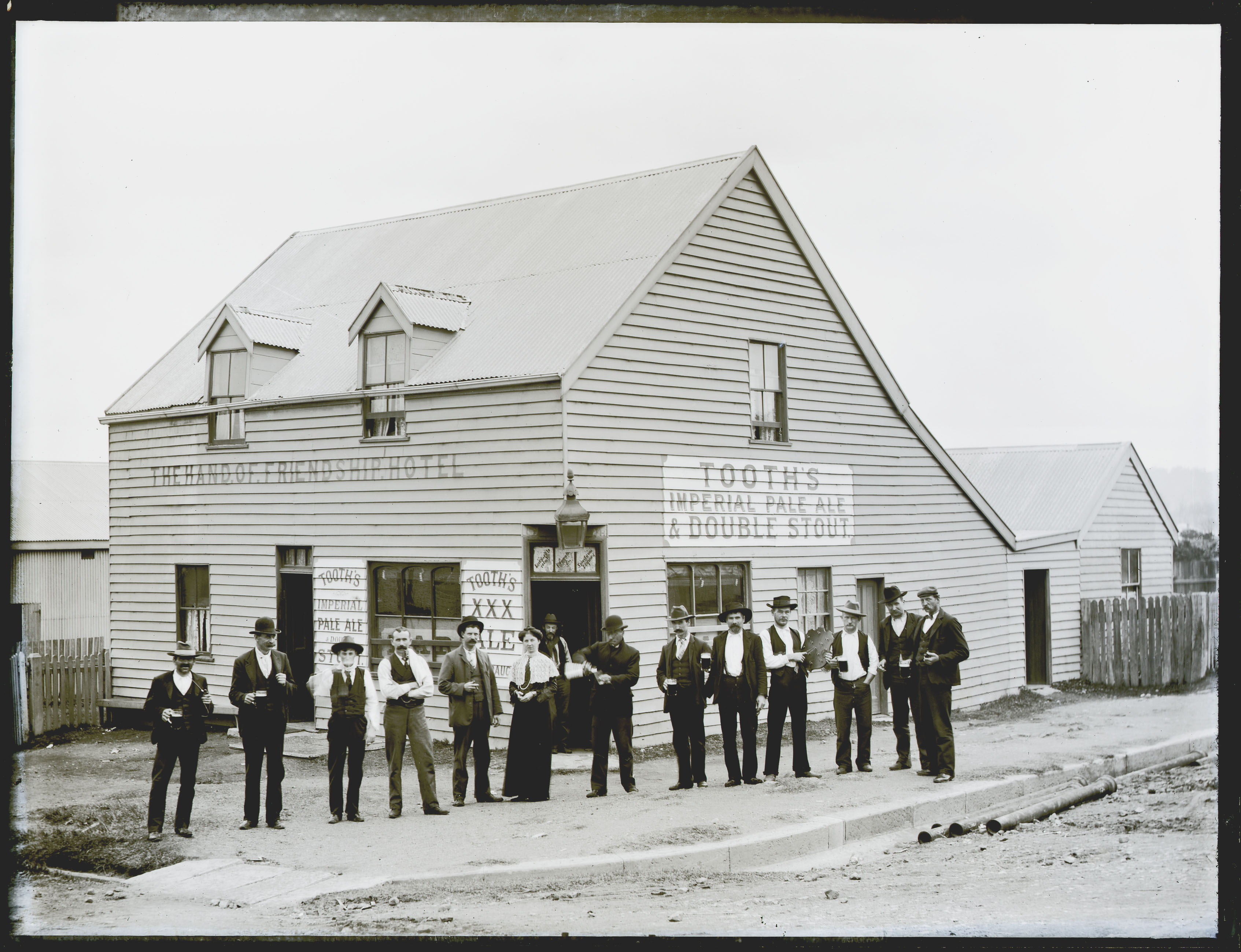
The Hand of Friendship Hotel was opened on 18 September 1869, its first publican Benjamin Lunn pledging in an advertisement the sale of “none but the very best wines, spirits, ales etc.” The premises also offered “abundant accommodation for the requirements of a colliery township.“
Advertisement for the opening of the Hand of Friendship Hotel. Newcastle Chronicle, 18 September 1869.
It was just the second hotel to open in New Lambton. Benjamin Lunn remained the publican until his death in 1878 when the hotel passed to his wife Jane, and later to their son James in 1884.
In November 1894, a stable in the course of erection at the hotel collapsed in a strong wind. Three children were injured, including the six year old daughter of the publican, George Masters, who had her leg badly fractured below the knee. Ralph Snowball photographed the hotel in September 1895, and the group standing at the door is almost certainly the publican of the day, George Masters, with his wife and two daughters. It is probable that the little girl on the right is the daughter who was injured in the accident the previous year.
The name of the publican “G. Masters” can be partially seen in a sign above the door, behind the lamp.
Snowball photographed the hotel again in 1903, with a larger group of people out the front.
Hand of Friendship Hotel, 2nd May 1903. Part of the Centenary Hall can be seen behind the hotel, at the left side of the photo. Photo by Ralph Snowball. University of Newcastle, Living Histories.
The diagonal writing in the three panels below the name says:
Licensed to retail | Fermented l(iquors) | Spirituous liquors
The publican at this time was Phillip James Byrne, having acquired the license from Edmund Butterworth three months earlier in February 1903. Note in the sign above the door there is a faint H at the end, which is probably the remnants of the name of the previous licensee.
In June 1903, just a month after Snowball’s photograph was taken, the application of Phillip James Byrne for a renewal of the license was objected to on on the grounds that “the accommodation was inadequate, and the place in an insanitary condition.” Despite the objection the renewal was granted for another year.
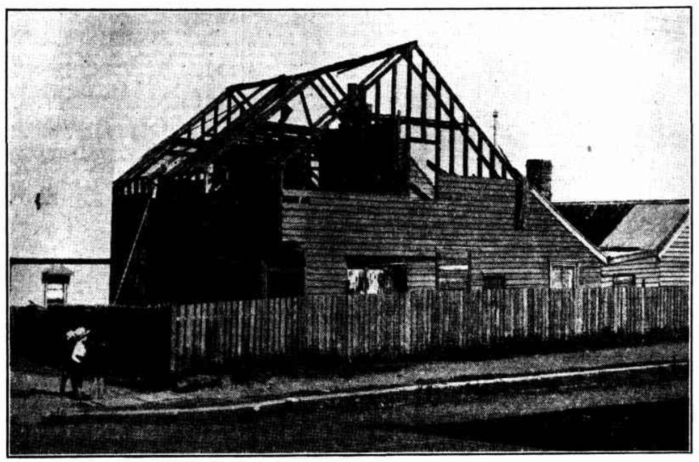
In 1905, with further deterioration, the police opposed the renewal of the hotel’s licence “on the ground that the building was in bad condition, owing to the white ants.” It survived that objection, but only for another year. Plans to demolish the building and erect a new hotel came to nothing, and in 1906 John Canning, the last publican to stand behind the bar of the Hand of Friendship Hotel, relinquished his licence.
The building stood idle for some time before it was sold, when it gained a new life as a second-hand goods shop. The weathering of the years however was relentless. In 1933 the building was finally demolished.
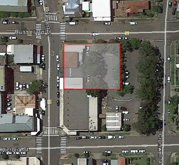
Demolition of the former Hand Of Friendship Hotel building in 1933.The site of the former Hand of Friendship Hotel, corner of Russell Rd and Regent St in New Lambton. March 2025.
Location
An 1877 map relating to the proposed site for New Lambton public school shows the Hand of Friendship Hotel on the south-east corner of Russell Rd and Regent St.
Map reproduced from the New Lambton Public School (1880-1980) Centenary booklet.A 1917 Water Board map shows the former Hand of Friendship Hotel building. University of Newcastle, Living Histories.Site of the Hand of Friendship Hotel and Centenary Hall, New Lambton.
Centenary Hall
In 1906 the hotel ceased to trade, and in January 1907, the owners of the building, Tooth and Co., put the property up for sale. The sale included the land, hotel building, and the Centenary Hall adjacent to the hotel and fronting Russell Rd. The land was described as having frontage of 133ft 4in to Russell St, and 98ft 3in to Regent St.
The following is a list of licensees as gleaned from various mentions in newspaper articles over the years. Some of the dates are known with certainty, as there is a report of the license being transferred from one person to another. For some licensees I have had to make an informed estimate based on the first and last reported association of the licensee with the hotel.
George Bertram Bowser (October 1906 to November 1906)
The 1933 article on the demolition of the building states that “Ben Bradley (afterwards an alderman in the New Lambton Council)” was also a licensee, but I can find no independent evidence for this. Benjamin Bradley did have a publican’s license at one stage, but it was for the Lake Macquarie Hotel in Teralba.
The article also states that Jack Canning “was the last to stand behind the bar of the old hotel”. Although this is true, he wasn’t the last licensee. George Bertram Bowser was the final licensee, for just under a month in October/November 1906. The report on the cancellation of his licence in November 1906 however, makes it clear that the building remained unoccupied during his short tenure as publican.
A general article describing the beginnings of New Lambton, that notes that the Hand of Friendship Hotel is the second hotel in the township. "Both these houses afford abundant accommodation for the requirements of a colliery township."
Reference in a court hearing to "James Lunn, hotelkeeper, at New Lambton". Although the hotel is not named, it is presumed that it the Hand of Friendship hotel.
The roof of a stable in the course of erection at the Hand of Friendship Hotel is blown off by a strong gust of wind. The building then collapsed and three children are injured, including the six year old daughter of the publican, George Masters, who had her leg badly fractured below the knee.
Advertisement. "FREE Public Dance, Monday Night, Butterworth's Centenary. Hall, New Lambton. Noble and Gaggetta, Musicians." The Centenary Hall was part of the Hand of Friendship Hotel site.
"The application of Phillip James Byrne for a renewal of the license of the Hand of Friendship Hotel, New Lambton, was objected to on a report, furnished by Sergeant G. Salter, to the effect that the accommodation was inadequate, and the place in an insanitary condition."
"John Canning, Hand of Friendship Hotel, New Lambton, applied for renewal of license. The police opposed the application on the ground that the building was in a bad condition, owing to the white ants. Mr. T. A. Braye (Messrs. Braye and Cohen) appeared for the applicant and said that plans had been prepared for a new building, which would be erected. Temporary improvements would also be made. Michael Joseph Moroney, representing the owners, Tooth and Co., confirmed this statement, and the renewal was granted."
Plans to build a new hotel on the site of the Hand of Friendship Hotel … "the firm of Tooth and Co. contemplate erecting a large hotel on the present site of their hotel property, situated at the corner of Regent-street and Russell-road."
LICENSING COURT. The following transfers were approved :- From John Canning to George Bertram Bowser, Hand of Friendship Hotel, New Lambton, and from Thomas Mclntosh to John Canning, Sportsman's Arms, New Lambton.
"In the matter of the Hand of Friendship Hotel, New Lambton, Sub-Inspector Goulder applied for cancellation of the license. The hotel changed hands on October 11, and since that date had remained unoccupied. The license, which was held by W. Bowser, was formally cancelled."
Report on the demolition of the Hand of Friendship Hotel building.
Sportsman’s Arms Hotel (1) (1870-1903)
In a 16 September1869 article on the rapid progress of New Lambton, the Newcastle Chronicle noted there were two hotels already and that “a third public-house is in course of erection, and the proprietor, Mr.Jones [sic], expects a license for it shortly after it is finished.” Just a few months later, on 22 January 1870, Nicholas Johns announced by way of advertisement the opening of the Sportsman’s Arms hotel.
The hotel was located on the north-west corner of Regent St and Portland Pl.
Portion of 1886 subdivision map showing Lot 6 of Section H, location of Sportsman’s Arms Hotel, leased to Nicholas Johns. State Library of NSW.
In 1895, John Thomas purchased from the New Lambton Land and Coal Company, lots 6 and 7 of Section H, where the hotel building was located. Subsequently on 6 May 1899, Marshalls Paddington Brewery Limited purchased the hotel land and building.
Purchase of Sportsman’s Arms Hotel by Marshalls Paddington Brewery Limited, 6 May 1899. Vol-Fol 1172-136
Three years later in July 1902, Marshall’s Brewery commenced plans to construct a new hotel building in Hobart Rd, with the intention of transferring the license of the Sportsman’s Arms to the new premises and closing the original hotel in Regent St. The transfer of the licence to the new location occurred a year later in July 1903. William Thompson, the last licensee at the old location, continued on as licensee at the new premises.
The old Sportsman’s Arms Hotel in Regent-street, which is one of the oldest buildings in the municipality, and in the early days was considered to be among the best of its class, is now closed, the license having been transferred to the new building recently erected by the Marshall’s Brewery Company in Hobart-road.
Newcastle Morning Herald and Miners’ Advocate, 4 Jul 1903.
The old hotel building was occupied as a private dwelling for about two years, but after being vacant for several months a fire destroyed the building in June 1905. There are no known photographs of the original hotel building.
The land was then owned by a number of different people in the next 17 years, and then on 20 November 1922 the Methodist Church purchased the land to erect a church building
Purchase of land by Methodist Church on 20 November 1922. Vol-Fol 1172-136
The New Lambton Uniting Church occupies the site today.
New Lambton Uniting Church, March 2025. Site of the first Sportsman’s Arms Hotel.
Licensees
Nicholas Johns [Jones] (January 1870 to March 1871)
William Thompson (c. July 1902 to June 1903 at Regent St, then continued as licensee at new premises in Hobart Rd)
Sportsman’s Arms Hotel (2) (1903-1987)
On 26 March 1902, William Masefield Bostock advertised …
… that I desire to obtain and will at the next Quarterly Licensing Court to be holden at Newcastle on the Third Day of April Next apply for a Certificate authorising the issue of a Conditional Publican’s License for premises proposed to be erected and situated at the corner of Alma-road and Lambton-road, and to be known by the sign of “Sportsman’s Arms,” and containing eleven rooms, exclusive of those required for the use of the family.
Newcastle Morning Herald and Miners’ Advocate, 26 March 1902.
At the licensing court held on 14 April 1902, Bostock stated …
… that he was an agent for Marshall’s Brewery Company, who had an hotel known as the Sportsman’s Arms Hotel, New Lambton, and he proposed to remove the license of that house to that for which he was applying for a conditional license. He had a guarantee, which he produced, from his company to close the Sportsman’s Arms should the new license be grant ed. The site of the proposed hotel was at the intersection of Alma-road and Lambton-road, opposite Roberts’ store. He did not own the land, but had taken certain steps to procure it.
Newcastle Morning Herald and Miners’ Advocate, 15 April 1902.
After hearing arguments the Bench refused the application “on the ground that the requirements of the place did not justify a license.”
The refused license did not deter the applicants. Foregoing their plans for a hotel on the corner of Alma and Lambton Rd, Marshall’s Brewery purchased lot 1356 on the corner of Hobart and Rugby Roads from William Thompson, and at a hearing on 4 July 1902 resubmitted their application for a conditional license. The police lodged an objection “on the ground that the requirements of the place did not justify the issue of a license”, the bench deferred their decision to a later hearing. After visiting the New Lambton and inspecting the existing hotels, and the site of proposed new hotel, the licensing bench granted the conditional license on 15 July 1902.
In April 1903 the newspaper reported that …
A large brick hotel is now being erected for Mr. Thomson overlooking the reserve, close to the tram terminus. The roof which is of red tiles, is now completed, and the contractor, Mr. Viggers. is busy finishing the interior to the designs of Mr. Henderson, architect.
Newcastle Morning Herald and Miners’ Advocate, 17 April 1903.
The new hotel opened for business just a few months later in July 1903.
The old Sportsman’s Arms Hotel in Regent-street, which is one of the oldest buildings in the municipality, and in the early days was considered to be among the best of its class, is now closed, the license having been transferred to the new building recently erected by the Marshall’s Brewery Company in Hobart-road.
Newcastle Morning Herald and Miners’ Advocate, 4 July 1903
Lot 1356 of the Newcastle Pasturage Reserve was formally purchased by Marshalls Paddington Brewery Limited, on 10 October 1902. Vol-Fol 1422-132
Photos from the from the Sportsman’s Arms Hotel ‘yellow cards’ in the ANU Open Research Repository shows that the exterior of the hotel remained largely unchanged during its lifetime.
The Wests Leagues Club purchased the Sportsman’s Arms hotel in 1987 and demolished it to enable an extension of their club premises.
The site of the former Sportsman’s Arms Hotel, corner of Hobart Rd and Rugby in New Lambton. March 2025.
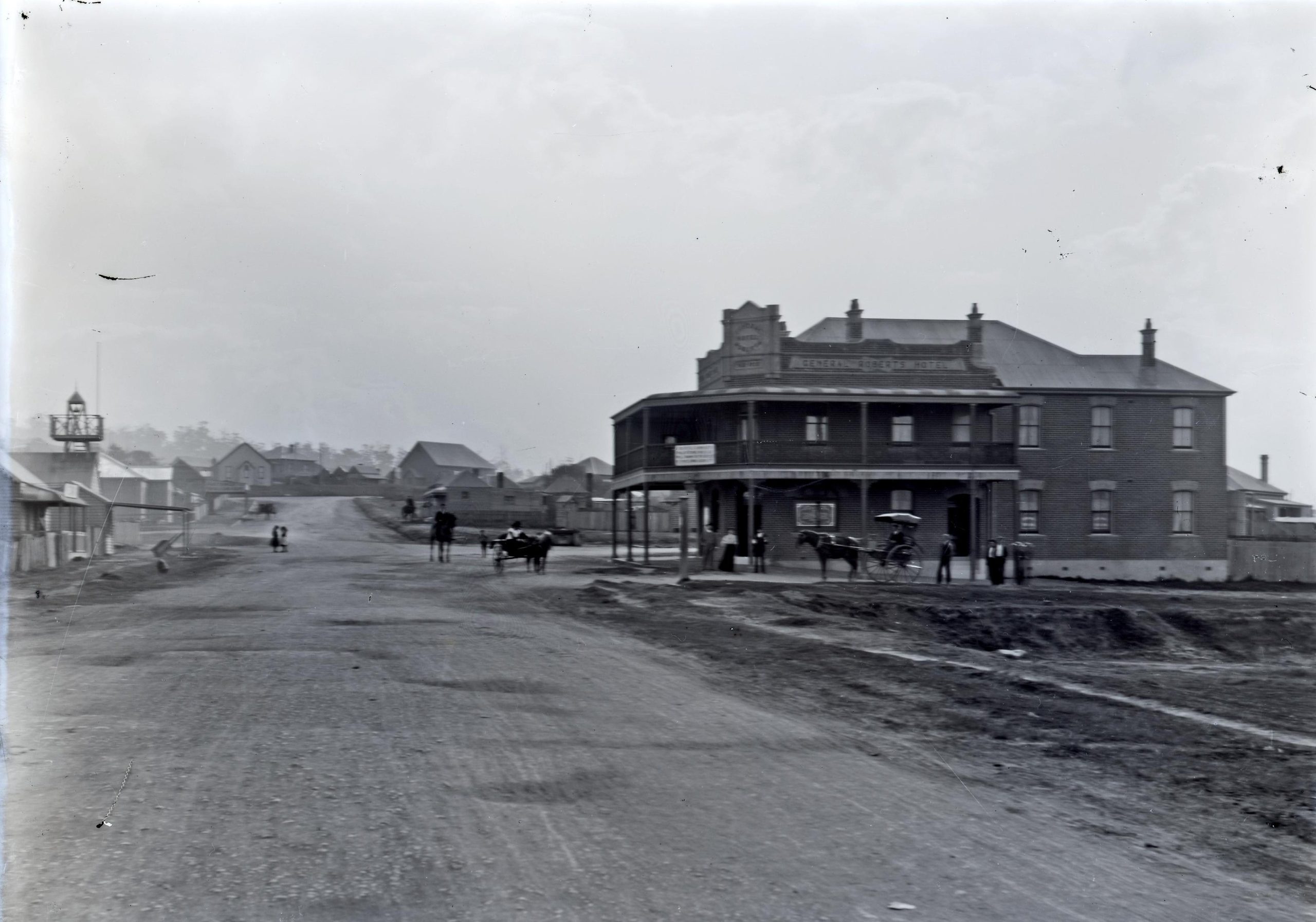
Commonwealth Hall
William Thompson, on the same day that he had purchased the land for the new Sportsman’s Arms Hotel, also bought another block of land on Hobart Rd. (Lot 1349,Vol-Fol 1750-42.) In 1903 Thompson erected a hall on this land, naming it the Commonwealth Hall, which was formally opened at a Fire Brigade social on 16 October 1903.
The Mayor (Alderman Errington), on behalf of the proprietors, declared the hall open. In doing so he explained that the building was to be known as the Commonwealth Hall. Alderman Errington referred to the rapid progress New Lambton was making, and said the building just completed, besides being an ornament, would be a valuable addition to the town.
Sportsman’s Arms Hotel and Commonwealth Hotel appear in a New Lambton panorama by Ralph Snowball. University of Newcastle, Living Histories.The name “Commonwealth Hall” can barely be discerned on the front of the building.A Newcastle Pasturage Reserve map overlaid into Google Earth, showing the location of the Commonwealth Hall on lot 1349.
In 1912 the licensee of the Belmont Hotel, John Sperring, purchased the hall and in July 1912 advertised that …
TENDERS are invited for taking down the Commonwealth Hall, situated at New Lambton, Removing, and Erecting at Belmont.
Newcastle Morning Herald and Miners’ Advocate, 6 July 1912.
A newspaper article in December 1913 spruiking the pleasures of Belmont noted that
The town possesses accommodation in the way of halls for entertainment, and within the past year Mr. Sperring, licensee of the Belmont Hotel, has erected a large hall adjoining the hotel grounds. The building is 70 feet long by 30 feet wide, and will seat comfortably about 500 persons. It has a large stage capable of mounting big acts. and the floor is well adapted for dancing. The building was previously the Commonwealth Hall at New Lambton, which Mr. Sperring purchased, and had re-erected, strengthened, and generally improved in its interior decorations. The hall is frequently used by moonlight excursion parties.
Mrs Catherine Anne Ruggeri (April 1950 to November 1957)
William Henry Murphy (November 1957 to July 1959)
William Smoker Boyling (July 1959 to April 1963)
Horace William Box (April 1963 to March 1965)
William Edward Compton (March 1965 to December 1978)
Roy Raymond Beverly (December 1978 to ????)
Nil Desperandum Hotel / Duckenfield Hotel (1876-1880)
The Nil Desperandum was New Lambton’s shortest-lived hotel, operating for just four years from July 1876 to June 1880. There are no known photographs of the hotel. The first mention of the hotel in the newspaper was a short notice on 15 July 1876 advising that …
Mr. Edgar Ashley [sic] has opened his new hotel under the name of Nil Desperandum.
Newcastle Morning Herald and Miners’ Advocate, 15 July 1876.
and on the same day an advertisement seeking a servant.
WANTED, a Female General Servant, one accustomed to a Public House. Apply Mrs. E. ASHBY, Nil Desperandum Hotel, New Lambton
Newcastle Morning Herald and Miners’ Advocate, 15 July 1876.
The Government Gazette of publican licenses for the year commencing 1 July 1876 lists Edgar William Ashby as the licensee of the Nil Desperandum Hotel, Griffen-street, New Lambton. Griffen Street (or more correctly Griffin) was the original name for what later became Victoria Street. The hotel was located on the south-west corner of Victoria and Cromwell Streets, on land leased by Thomas Sneddon (sometimes spelled Sneddan) from the New Lambton Coal Company.
1886 New Lambton subdivision map, showing Sneddan’s Lease on Griffin Street (Lots 1-4, Section G). State Library of NSW.
In 1878 Edgar Ashby constructed a music hall on land adjoining the hotel, and formally opened the hall on 21 May 1878.
Mr. Ashby, landlord of the Nil Desperandum, has, at a considerable cost, erected a fine hall adjoining his hotel. The building is 36 feet by 24 feet, and is to be fitted up for all kinds of public entertainments and meetings. This is a want which has long been felt by the people of New Lambton, and especially the miners, who have never had a proper place to meet in. The hall is to be opened on Tuesday, the 21st inst., by a grand ball and supper.
Newcastle Morning Herald and Miners’ Advocate, 14 May 1878.
We are left to wonder about the details, but something was awry in the Ashby family. Edgar Ashby place the following advertisement in July 1879.
I EDGAR ASHBY, of New Lambton, will not be responsible for any debts contracted by my wife, JANE ASHBY, from this date.
Newcastle Morning Herald and Miners’ Advocate, 25 July 1879.
The following month the license of the hotel changed hands, with an advertisement on 21 August 1879 announcing that …
HENRY DOHERTY, (LATE OF THE RACE HORSE INN, LAMBTON), HAVING TAKEN THE NIL DESPERANDUM HOTEL, New Lambton, hopes, by keeping the BEST BRANDS of Wines, Spirits, and Ales, to merit a fair share of the public patronage.
Newcastle Morning Herald and Miners’ Advocate, 21 August 1879.
The new licensee also took over the operation of the adjoining hall, and there a few references to “Doherty’s Hall” in 1878 and 1879. On 11 June 1880, Henry Doherty advertised for sale “the Lease, License, Furniture, and Stock” of his hotel in New Lambton. There appears to have been no takers on this offer from the licensee (Henry Doherty), and 17 days later the lessee (Thomas Snedden) was advertising the hotel for rent.
TO LET, the Nil Desperandum Hotel, New Lambton, with Concert Hall, and every convenience. Rent moderate. Apply to THOMAS SNEDDEN, Storekeeper, New Lambton.
Newcastle Morning Herald and Miners’ Advocate, 28 June 1880.
This advertisement also seems to have been met with a stony silence, for there is no further mention of the hotel as a going concern. The hotel building was demolished in 1937 and the music hall demolished in 1949.
In Cromwell-street, New Lambton Mr. S. Bagnall spent the week completing the demolition of a building. Casual passers-by might have thought it was just a garage that had served its. day, but old stagers knew it was more than that. It was one of the district’s oldest private halls. There was scarcely room to swing a hip, if you gauged by modern standards, for the wooden hall was only 40 by 26 feet. The hall was part of the Nil Desperandum Inn, which stood on the corner of Cromwell and Victoria Streets. It was run by the innkeeper, Mr. Tom Sneddon, sen., a native of Dalkeith, Scotland.
At the back of both buildings the innkeeper planted a small forest of camellia trees. About 100 trees remain, 70 to 80 years old, still blossoming and supplying city florists.
Somewhere along the years the inn was closed and became a private residence for Mr. and Mrs. Sneddon and their children-two boys and two girls. The bar was partitioned off and let as a doctor’s surgery. The dance hall was also closed. It was used to store the odds and ends that in houses with attics are usually hidden in the ceilings. In 1937 the inn was demolished, but the hall remained. Soon, all that will remain of the Nil Desperandum and its hall will be the camellia forest and the inn’s 20ft. well.
Newcastle Morning Herald and Miners’ Advocate, 1 October 1949.
1917 Water Board map showing the former Nil Desperandum hotel building (yellow) and the music hall (green). Composite of maps 246 and 247, University of Newcastle, Living Histories.
A 1938 aerial photo of New Lambton shows an empty space on the corner where the hotel building was demolished the year before. The hall and the camellia garden at the rear is still visible.
The site of the former Nil Desperandum Hotel, corner of Victoria and Cromwell St in New Lambton. March 2025.
Duckenfield Hotel
Between 1877 and 1880 there are a handful of references to a “Duckenfield Hotel” in New Lambton. While there is no definitive proof, the available evidence strongly suggests that this was the Nil Desperandum hotel trading with a different name.
All the references to the Duckenfield Hotel (1877 to 1880) are in the same range of years for the Nil Desperandum Hotel (1876 to 1880)
There are no references where both hotels are mentioned together, which would conclusively prove they were different hotels. Crucially, the Government Gazette licensee lists in this period only ever contain one of the two names, and always on the same street, with the same licensee.
1876 – Edgar William Ashby, Nil Desperandum, Griffen St
1877 – Edgar William Ashby, Duckenfield, Griffen St
1878 – Edgar William Ashby, Duckenfield, Griffin St
1879 – Edgar William Ashby, Duckenfield, Griffin St
In August 1879 Henry Doherty advertised his taking over of the Nil Desperandum Hotel, but just four months later in December 1879 there is a reference to “Doherty’s Duckenfield Hotel”.
In June 1880 there are two references to a hotel in New Lambton being up for lease – Doherty’s Duckenfield Hotel on 11 June 1880, and the Nil Desperandum Hotel on 28 June 1880. Neither hotel is heard of again. It seems highly unlikely that two different hotels on the same street would disappear from the records in the same month.
The Duke of Wellington hotel was first introduced to the public in a brief article of New Lambton news on 15 July 1876 that mentions that …
… another [new hotel] will shortly be opened by Mr. D.Jones.
The Government Gazette of publicans’ licenses issued for the year commencing 1 July 1876 has an entry for “David Jones, Duke of Wellington Hotel, Horsefield-street, New Lambton.” Horsfield Street was the original name for Regent Street, and the hotel was located at its present site on the corner of Regent Street and Portland Place, on Lot 6 of Section 6, which was leased by the New Lambton Coal Company to Abraham Butterworth. Abraham Butterworth was the second licensee of the hotel, for a brief period from April 1878 to February 1879.
The first photograph of the Duke of Wellington Hotel dates from the time of the eighth licensee, Joseph Garratt (1887 to 1895). The photo shows a very basic weatherboard building, as were all the early New Lambton hotels. This was because up until about 1886 the New Lambton Coal Company did not sell any of their land for housing or businesses, but only provided 14 year leases. Naturally, residents and businessmen were reluctant to build any substantial structures on land they did not own or control in the long term. As a consequence, in contrast to neighbouring Lambton, no substantial building in New Lambton from the 19th century has survived to the present day.
After the New Lambton Coal Company started selling land, Abraham Butterworth purchased the Duke of Wellington building and land in 1891. (Vol-Fol 1006-20)
In 1898 George Burt made improvements and additions to the hotel.
Among the number of new buildings lately erected in this municipality are the improvements and additions made at Burt’s Duke of Wellington Hotel. Particular attention has been given to make the alterations roomy, with plenty of ventilation, and a good height, the bar and parlours being very noticeable in this respect. A staircase 3ft wide leads to the hall, 16 x 32, which is intended for a lodge or supper room.
Newcastle Morning Herald and Miners’ Advocate, 6 June 1898.
In 1919 Abraham Butterworth sold the property to the Castlemaine Brewery and Wood Brothers. (Vol-Fol 1006-20, p2). In August 1921, at a Licensing Court hearing …
Permission was given to Paul Turnbull, licensee of the Duke of Wellington Hotel, New Lambton, to erect a new brick building.
The fittings, fixtures and timbers of the old hotel building were put up for auction on Saturday 10 September 1921. Strangely for such a major project, the newspaper contains no reports on the demolition of the old building, or the construction and re-opening of the new building. A photo from 1924 shows the building with clean sharp brickwork and the year “A.D. 1921” prominently displayed on the corner facade.
In September 1954, Pitt & Pitt architects called for “tenders for extensive alterations and additions, to Duke of Wellington Hotel for Tooth & Co.” Presumably these were the alterations that ‘modernised’ the exterior, and arguably denuded the building of its 1920s architectural charm.
The Sunnyside Tavern is located in Broadmeadow Rd, Broadmeadow. I have included it in this page of New Lambton Hotels, as this location fell within the borders of the New Lambton Municipal Council which operated from 1889 to 1938.
Specifying the location of the Sunnyside has always been problematic, as the names and boundaries of suburbs in this area have changed over time. Here are some examples of the different locality names the hotel has been placed in over the years …
This map of modern suburb boundaries shows that here are four other suburbs within 350 metres of the Sunnyside Tavern in Broadmeadow: Waratah, Georgetown, Hamilton North, and New Lambton.
On 17 June 1884, Michael Fenwick of Waratah, gave notice in an advertisement of his intention to apply at the next Licensing Court for …
… the issue of a Publican’s License for premises situated at Broad Meadows Road, between Waratah and Hamilton, and to be known by the sign of “Sunnyside Inn,” containing six rooms, exclusive of those required for the use of the family.
Newcastle Morning Herald and Miners’ Advocate, 17 June 1884.
Four months later another advertisement announced …
SUNNYSIDE INN, BROAD MEADOW. MICHAEL FENWICK desires to intimate to his many friends and the public that he has OPENED the above NEW INN, and is now prepared to accommodate all who may favour him with a call.
The establishment was equally referred to as the “Sunnyside Inn” and “Sunnyside Hotel” in its first 30 years. There are no known photographs of the first hotel building. In 1903 Joseph Heslop became licensee, and progressed plans for significant renovations to the hotel building.
Tenders are due on Saturday for important extensions to the Sunnyside Hotel, Broadmeadow-road, near Georgetown. It is proposed to add a floor space above at this hotel and have a colonnade. This work will involve an outlay of £500 or £600.
Newcastle Morning Herald and Miners’ Advocate, 2 July 1904.
By October the renovations were well underway.
The Sunnyside Hotel has been pulled down all but four rooms, and a brick two-storey addition erected of twelve rooms, with a colonnade in the centre and balconies on each side. The stable buildings are also to be made in keeping with the hotel, and when all is completed (by Messrs. Bates and Everett, the builders) this will be a well-appointed establishment.
Judging by the shiny corrugated iron roof and crisp paintwork, Ralph Snowball photographed the hotel building not long after the renovations were completed.
Around the time of Joseph Heslop’s tenure and the renovation in 1904, use of the name “Sunnyside Inn” declined, and afterwards it was principally referred to as the “Sunnyside Hotel”.
A 1909 Water Board map shows that an extension had been made at the northern end of the building. This was possibly the stables alluded to in the October 1904 report.
The Sunnyside Hotel is marked on a locality sketch on a 1919 real estate poster for a subdivision of 72 building sites in “Hamilton – Newtown”. University of Newcastle, Living Histories.
In March 1921 Tooth and Co purchased the hotel, and in July 1921“Percy George Phillips, licensee of the Sunnyside Hotel, was granted permission to make alterations and additions to his premises.” The alterations were in progress by December, and completed by April 1922 when the Newcastle Sun reported on the new hotel building.
Residents of the Newcastle district are agreeably surprised when passing through Georgetown at the view of the re-constructed Sunnyside Hotel. The old building which is true was a landmark of this locality, was entirely demolished, and in its stead has been erected a modern hotel of pleasing design. The new premises contain a commodious bar, two parlors, store room, office, public and private dining-rooms, kitchen, pantry and laundry, and the necessary lavatory; accommodation on the ground floor and on the first floor there are 14 bedrooms, sitting-room, two bathrooms, linen cupboards, and other conveniences. The outside walls are tiled up to height of the sill, and a suspended awning protects the front. The work was carried out by Mr. R. E. Waller, to the plans and under the supervision of Mr. W. L. Porter, architect, at a cost of approximately £1,500.
Ed Tonks on page 13 of his book “No Bar To Time” notes that the establishment was changed from a hotel license to a tavern license on 29 May 1978, and the name change to “The Sunnyside Tavern” probably occurred at that time also.
The Sunnyside Tavern, March 2025.
Licensees
Some details of licensees after 1919 are taken from the Sunnyside Hotel ‘yellow cards’ in the ANU Open Research Repository.
In 1898 Frederick George Roberts purchased land on the corner of Lambton and Tauranga Roads.
Portion 1324 was purchased by Frederick George Roberts of Waratah, hotelkeeper, on 18 November 1898. Vol-Fol 1021-213.
Map from land title Vol-Fol 1021-213, showing portion 1324, the site of F G Roberts store and then the General Roberts Hotel. Note the New Lambton colliery railway running north to south, under a bridge on Lambton Road.
After purchasing the land, Roberts built a weatherboard store, selling groceries, draperies, ironware and clothing.
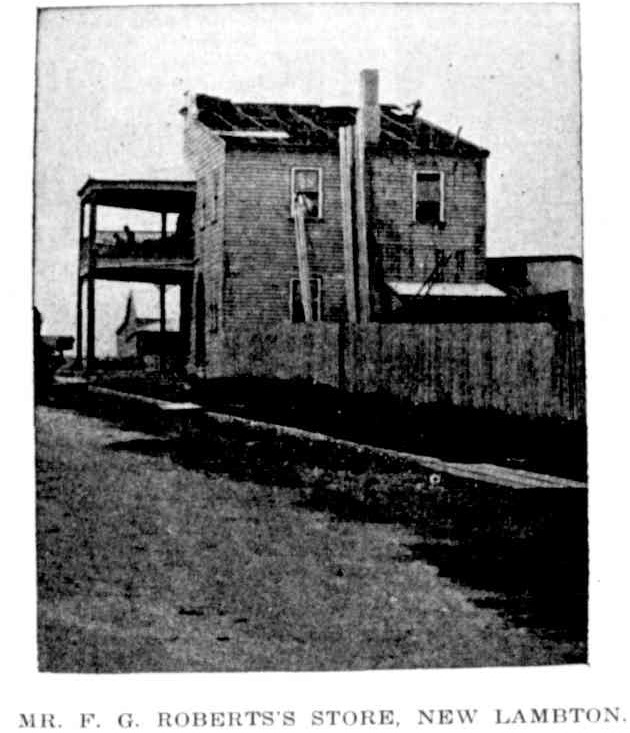
Roof damage to F G Roberts store in New Lambton due to cyclonic wind storm on Tuesday 7 November 1899. Photo by Ralph Snowball. Australian Town and Country Journal, 18 November 1899.F G Roberts Store, Lambton Rd, New Lambton, NSW, [1902]. Photo by Ralph Snowball. University of Newcastle, Living Histories.
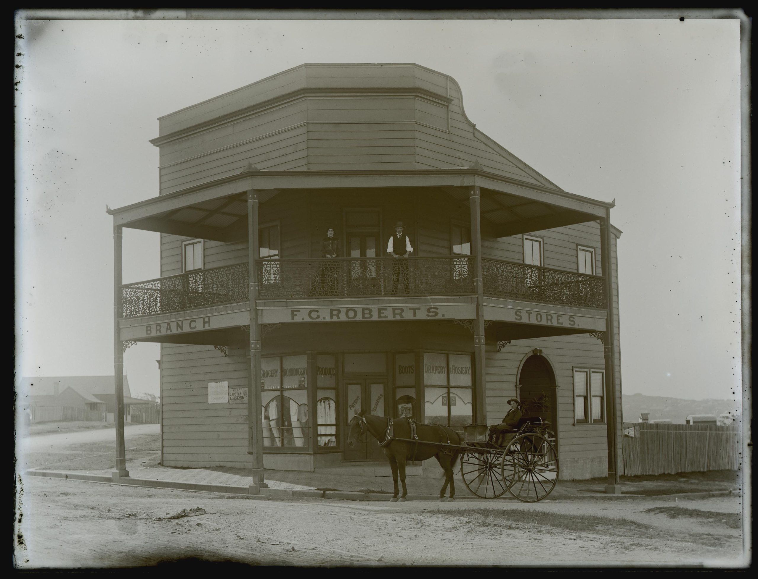
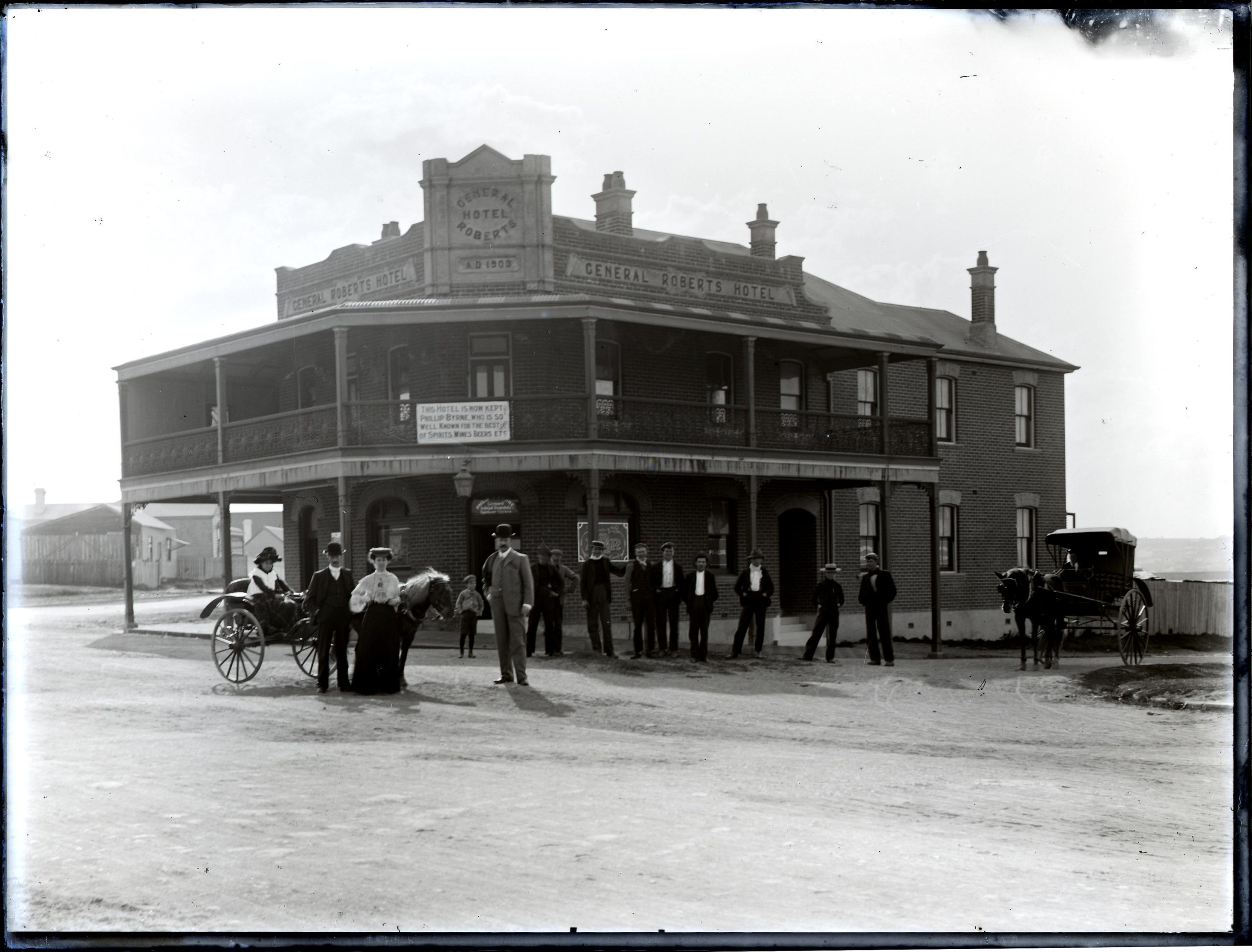
In July 1902 Roberts applied for a publican’s license to open a hotel on the site of his store. Despite police objections the licensing court granted the application, in part swayed by Roberts’ plans to erect a substantial brick hotel, in contrast to the other hotels nearby that were described at the time as “a very disappointing lot indeed”.
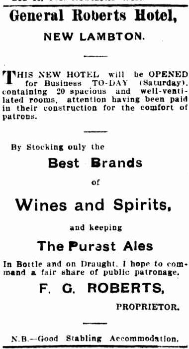
By September 1902, the store was demolished, and the builder William Knight was constructing a new brick hotel designed by the notable local architect Ernest George Yeomans. On 18 April 1903 Roberts announced by advertisement that his “new hotel will be opened for business today, containing 20 spacious and well ventilated rooms.” He named it the General Roberts Hotel, after Frederick Sleigh Roberts, recently commander of the British forces in the Second Boer War.
Advertisement of the opening of the General Roberts Hotel. Newcastle Morning Herald and Miners’ Advocate, 18 April 1903.
At the corner of the main road and Tauranga-street another brick hotel of 18 rooms, to be known as “The General Roberts,” has just been completed. This is built with red, pressed, tuck-pointed fronts and ornamental parapets. The fronts have those useful adjuncts, spacious colonnades. The building is tastefully finished both inside and out, and standing on a prominent site is a landmark in the municipality. Formerly on this site stood Mr. Roberts’ w.b. store, which has been demolished to make place for this hotel. The architect was Mr. E. G. Yeomans. and the builder Mr. W. Knight.
Newcastle Morning Herald and Miners’ Advocate, 17 April 1903.
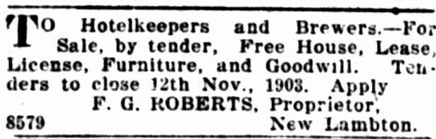
Within six months of opening the hotel, F G Roberts was looking to sell the hotel business, but retain ownership of the land and buildings.
Advertisement of the sale of the General Roberts Hotel business. Newcastle Morning Herald and Miners’ Advocate, 23 October 1903.
Phillip Byrne became licensee in April 1904, and Ralph Snowball photographed the hotel soon afterwards in July 1904. Looking west along Lambton Rd and Alma Rd, the photo shows the General Roberts Hotel on the right, and beside it the remnants of a cutting where the New Lambton colliery railway once ran.
"I FREDERICK GEORGE ROBERTS give notice that I desire at the next Quarterly Licensing Court, to apply for a CONDITIONAL PUBLICAN'S LICENSE for Premises situate at New Lambton already erected at the corner of Lambton-road, but requiring additions and alterations to make them suitable to be licensed. These premises, if a license be granted, are to be known as the GENERAL ROBERTS HOTEL, and will contain when completed, eight rooms exclusive of those required for the use of my family."
"At the Licensing Court to-day an application was made by Frederick George Roberts for a conditional publican's license for premises situated on the main Newcastle Cardiff road at New Lambton, proposed to be used as an hotel." Decision reserved pending the hearing of two other applications for hotels in the vicinity.
"At Newcastle Licensing Court, Frederick George Roberts applied for a publican's conditional license for premises to be erected on the Lambton-road, New Lambton … Ernest George Yeomans. architect, deposed that he prepared the plans before the court. The house would have brick walls."
"Frederick George Roberts applied for a conditional publican's license for premises to be erected at New Lambton." The Bench had inspected the current hotels "and found them a very disappointing lot indeed, and the existing accommodation was not sufficient." Application of F G Roberts was granted.
"The work of excavating for the foundations of the new hotel which is to be built at the corner of Taurangua and Lambton roads, is well forward. The building, which is to be commodious and substantial,
will, it is estimated, cost between £1600 and £1700. Mr. William Knight is the contractor and Mr. Yeomans the architect."
"Frederick G. Roberts applied for a certificate for a publican's license for premises at New Lambton, to be known as the General Roberts Hotel. The application was granted."
Phillip James Byrnes applies for the renewal of his licensee for the Hand of Friendship Hotel. The renewal is objected to due to unsanitary premises and inadequate accommodation. By April 1904 Byrnes is licensee of the General Roberts Hotel.
"TO Hotelkeepers and Brewers.- For Sale by tender, Free House, Lease, License, Furniture, and Goodwill. Tenders to close 12th Nov.; 1903. -Apply F. G. ROBERTS, Proprietor, New Lambton."
"NOTICE.-Having taken over the license of the General Roberts' Hotel, New Lambton, where I hope to see all my old friends and acquaintances. JOHN KEIM, Late of Tighe's Hill."
"Considerable damage was done yesterday to the balcony of the General Roberts Hotel at the corner of
Lambton and Taranga Roads, New Lambton. A coal-laden lorry knocked out two of the posts on the gutter
alignment and the balcony flooring sagged."
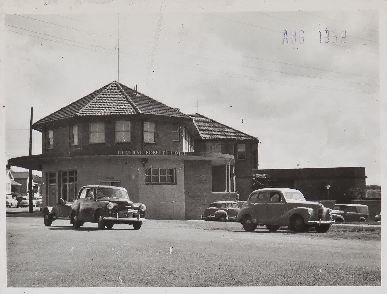
Applications for the demolition and rebuilding of 12 hotels, including the General Roberts Hotel in New Lambton.
Blackbutt Hotel (1956 to present)
Between April and October 1950, James William Hall, hotel proprietor of Wickham, purchased Lots 42-45 on the corner of Orchardtown Rd and Carnley Ave in New Lambton.
In October 1950, at the Newcastle Licensing Court …
… Alexander Jones, licensee of the Holmesville Hotel, [applied] for the transfer of the licence to a hotel to be built at the corner of Orchardtown-road and Carnley avenue, New Lambton.
Arguments for and against the transfer were presented, and the hearing concluded with the chairman saying that “the evidence would be considered before the Bench gave its decision in Sydney.” The application was evidently unsuccessful, for no more was heard of it.
The following year, in July 151, Margaret Christina Delaney made application for the transfer of the licence of the Royal Standard Hotel in Adamstown …
… to proposed premises at the corner of Orchardtown road and Carnley-avcnue, Kotara … It was stated that the proposed new hotel would be of two floors. On the ground floor there would be a public bar and saloon bar, large lounge and beer garden. Upstairs, there would be eight single bedrooms and four double bedrooms, with accommodation for the staff. The building would have a tiled front with faced red brick. There would be a frontage of 137 feet to Carnley-avenue and 139 feet to Orchardtown-road.
Newcastle Morning Herald and Miners’ Advocate, 11 July 1951.
Ed Tonks on page 74 of his book “No Bar To Time” notes that “conditional approval to transfer the licence was granted on 2 August 1951”. Despite the approval, construction of the new hotel did not commence for a number of years. A 1954 aerial photograph shows an empty block on the corner of Carnley Ave and Orchardtown Rd.
A 1954 aerial photograph shows the empty block awaiting construction of the Kotara Hotel. The portion of Carnley Ave west of Orchardtown Rd has not yet been constructed. NSW Historical Aerial Imagery
Card 1 of the Blackbutt Hotel ‘yellow cards’ in the ANU Open Research Repository indicates that “Final order for removal of license from Royal Standard Hotel granted 21.12.56” and that the new Kotara Hotel commenced trading in June 1957.
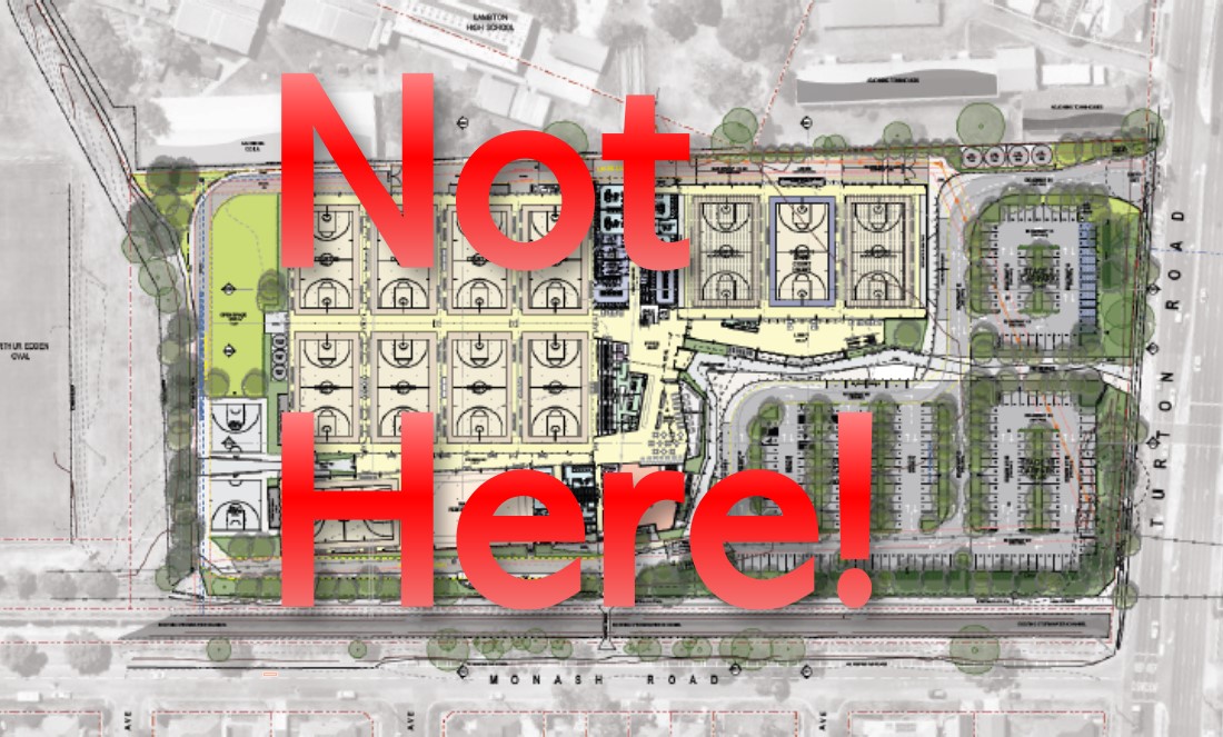
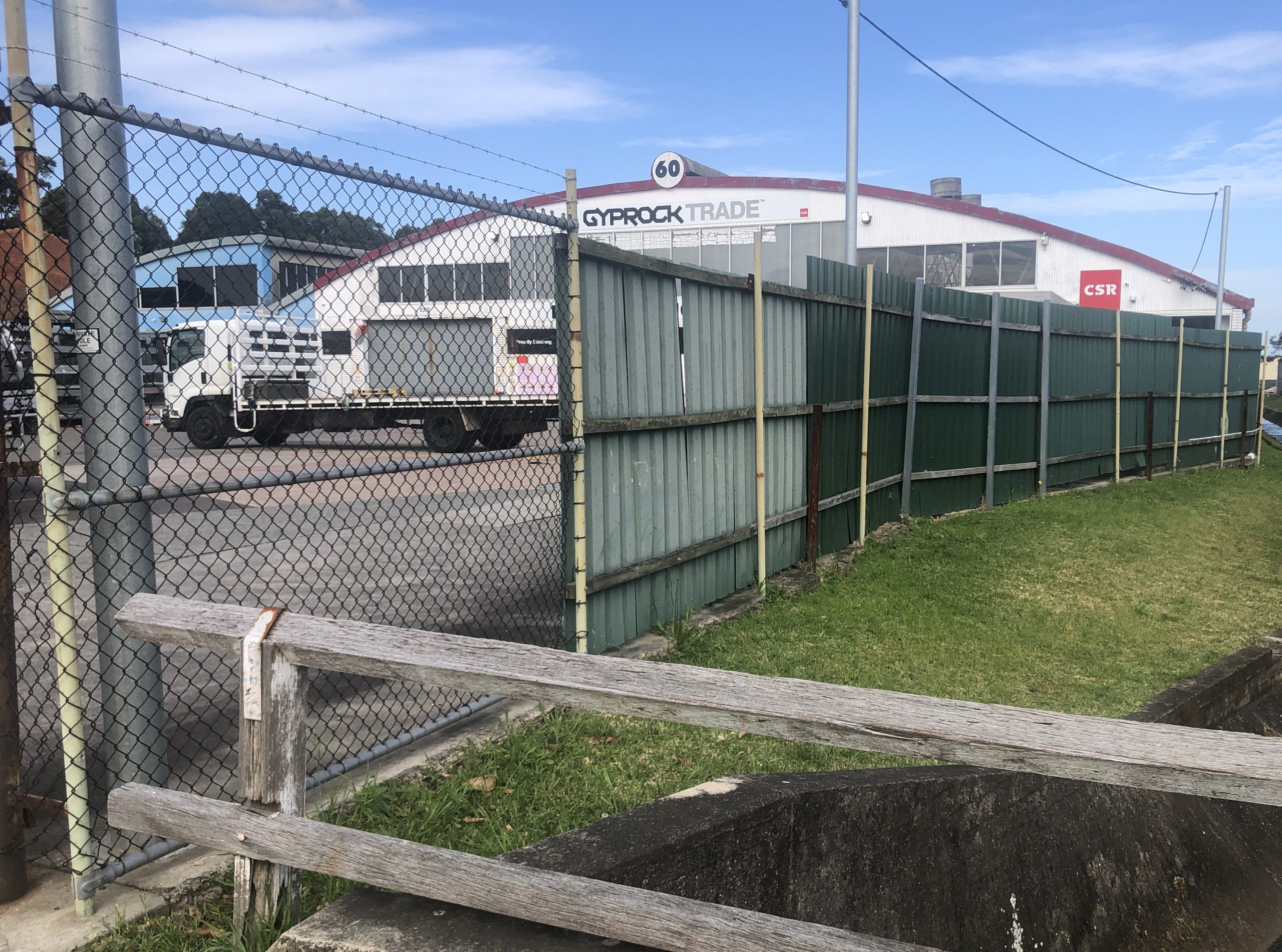
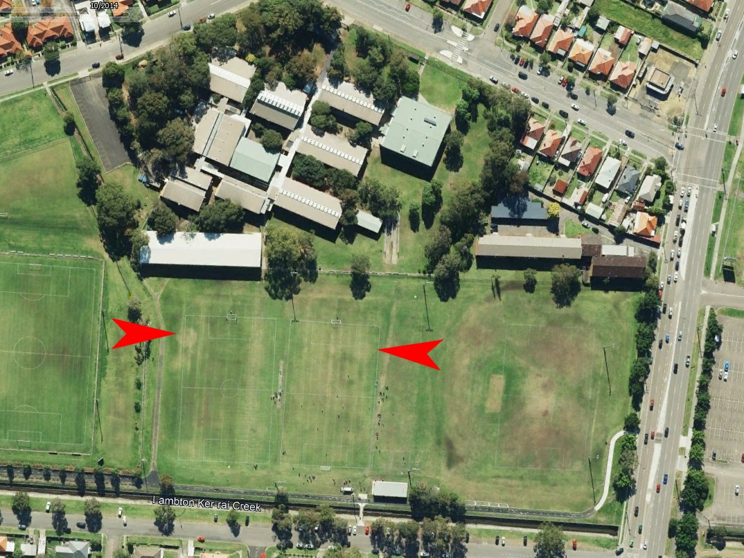
I was reading a newspaper article today about a public meeting protesting the impending loss of park land at the location of Wallarah and Blackley Ovals in New Lambton. One contributor to the meeting said …
A park of considerable dimensions was required in their midst. There was every probability that the population would increase, which made it all the more necessary that they should have all the parks they could get for recreation purposes.
Interestingly, this statement is not from 2024/2025 when the NSW State Government (in collusion with Newcastle Council) want to hand over much needed sporting fields for the construction of a basketball stadium. No, this is from a public meeting 126 years ago on 15 May 1899. Attendees at the meeting were railing against the state government’s plan to sell into private ownership, at bargain basement prices, large swathes of publicly owned land previously promised for a district park.
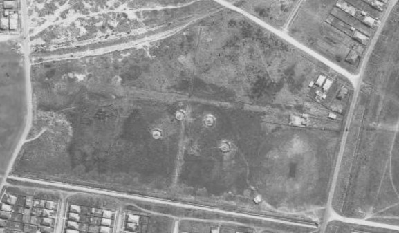
Fortunately for us now, the community back then kicked up such a fuss that within a couple of months the government revoked their plans for the sell off. The image below shows an old parish map that has the Homestead Selection Area 585 outlined in red. I have overlaid this into Google Earth then shaded in green the areas that are still green space or used for public recreation today. This amounts to 35 hectares of land that we would not have now if the residents of 1899 had not been vigilant, and actively protested the government’s intentions to flog off public land to the public’s detriment.
The old battle is with us anew.
Historical parish map showing the 1899 Homestead Selection Area 585 outlined in red, with areas still used for public recreation today shaded in green. Parish map from Historical Land Records Viewer.
On 13 December 1920 the “YY Aerated Water Company” was registered in Newcastle for the purpose of acquiring the business of Healey Brothers, a manufacturer of aerated water and cordials in Wickham. The name of the company was inspired by the daughter of one of the company directors, who on her recent honeymoon in New Zealand learned of the Maori word “wai-wai”, meaning “running water”.
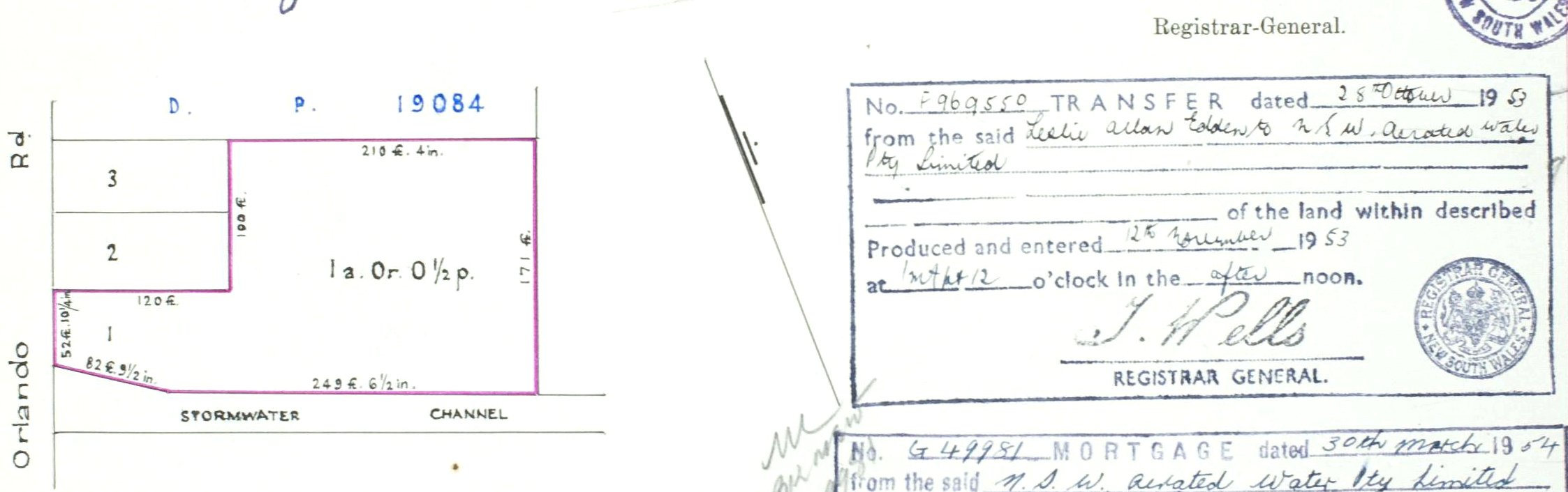
In 1937 the company opened a new modern factory in Wickham, with electrically driven machinery. With continued success in the following decades, in 1958 Newcastle City Council approved the company’s application to construct a larger factory in Verulam Road Lambton, at a cost of £25,000.
YY operated in a time when glass bottles were valuable. When you bought a soft drink you purchased the contents but not the container, which had a label reminding that “This bottle is not sold and always remains the property of YY Aerated Water Co.” Consumers received a small deposit refund when returning bottles, which were taken back to the factory to be washed and re-used. In 1965 YY installed a new £15,000 “Bellock” automatic bottle washer in their Lambton factory.
In the 1970s the production of soft drinks came to be dominated by a few multi-national corporations, and smaller operations like YY struggled to compete. After trading at a loss for several years, on 30 August 1983 YY ceased production at Lambton with the loss of 12 jobs. The company closed after 63 years of operation.
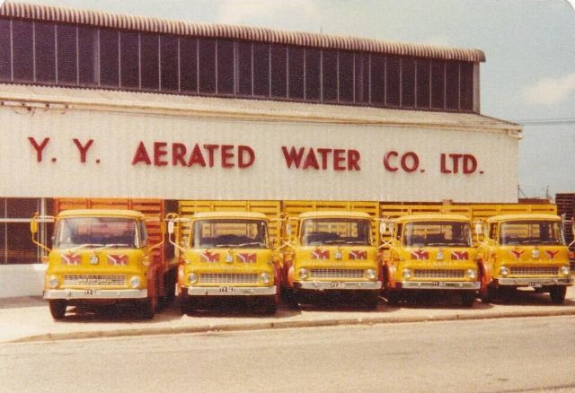
Just a week later another small soft drink factory in Lambton announced its closure, with the loss of 15 jobs. The Schweppes facility had been operating in Orlando Road since 1954, but the company decided to cease local production to concentrate manufacturing in Sydney instead. YY may have left Lambton over 40 years ago, but their fleet of brightly coloured trucks and catchy slogan “First for Thirst” will still be a fond memory for many a Novocastrian.
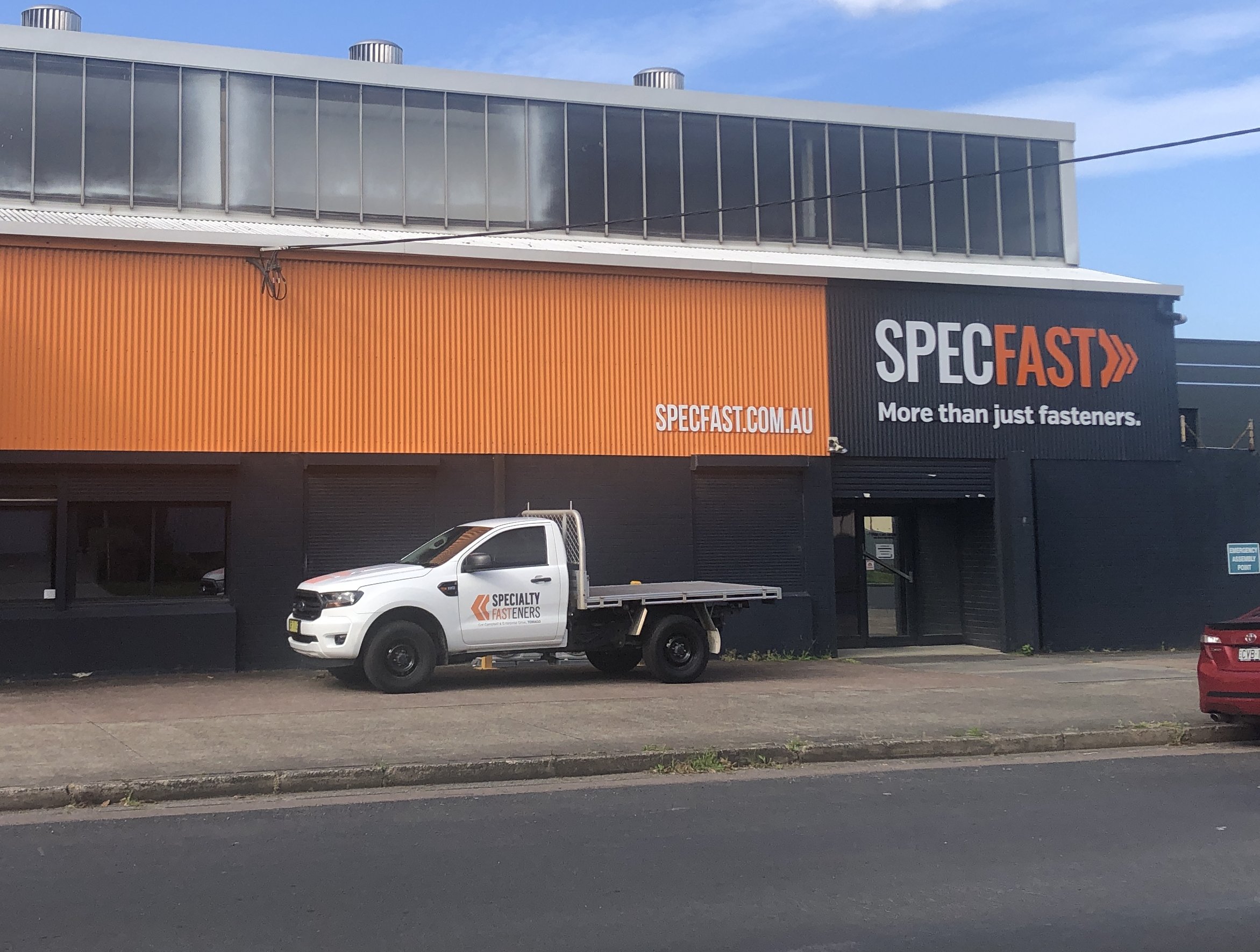
The YY factory in Verulam Road, Lambton. Photo from Lost Newcastle Facebook group.The former YY factory building still stands in Lambton today.
The article above was first published in the November 2024 edition of The Local.
Additional Information
In the 1950s, two different cordial manufacturing companies opened factories in Lambton – the YY Aerated Water Co, and the NSW Aerated Water Company. Because of the similarity of name, company mergers and acquisitions, the proximity of their factories in Lambton, the fact that they both had moved from Wickham, and that they both closed in 1983, the two companies are easily confused. To make sense of them the table below shows a timeline summary with a separate column for each company.
Year
YY Aerated Water Co
NSW Aerated Water Co / Schweppes
1876
Auguste Ferriff moves from Murrurundi to Newcastle to produce aerated waters at premises in Darby St. NMH 28/08/1876, NMH 17/11/1876
1877
George E Redman, purchases equipment from Ferriff, who has ceased manufacturing. Redman commences manufacturing in Newcomen Street. NMH 02/03/1877
1891
First mention of Healey Bros, with cordial factory in Hamilton. NMH 21/07/1891
1896
Formation of NSW Aerated Water and Confectionery company, by the amalgamation of several existing companies: Coleman Bros, G Redman, Rowland Bros. NMH 23/12/1896
1900
Healey Bros cordial factory now in Wickham. NMH 10/03/1900
1920
YY Aerated Water Company formed and acquires Healey Brothers cordial manufacturer. DCNASL 28/12/1920
1937
New factory in Wickham with electrically driven machinery. NS 13/09/1937
Application to Newcastle Council to build new factory in Lambton. NMH 20/08/1958
1959
Purchase of land in Verulam Road Lambton for new factory. Vol-Fol 4758-152
1965
New automatic bottle washer. NS 15/11/1965
1967
NSW Aerated Water Co acquired by Schweppes Australia. NMH 10/11/1967
1983
Factory closed. NH 31/08/1983
Factory closed. NH 08/09/1983
YY Aerated Water Co
Purchase of land in Verulam Road Lambton, 17 January 1959.Vol-Fol 4758-152.
NSW Aerated Water Co/Schweppes
Purchase of land in Orlando Rd Lambton, 28 October 1953. Vol-Fol 6014-246.The Schweppes office and factory in Orlando Road Lambton, 1983.The former Schweppes soft drink factory building in 2024. The brick office building in front of the arched factory was demolished sometime between 1987 and 1993.
Firstly, the Scoping Report has a section on Community Engagement, that has a list of stakeholders that Newcastle Basketball has “undertaken consultation with to inform the project planning.” Conspicuously missing from this list are the two groups that will be most negatively impacted by the project.
The sporting groups who currently use the ovals.
The local residents who will have to suffer the traffic and parking chaos the development will cause.
I am at a loss to decide whether these omissions are due to incompetence, error, conflict avoidance, or deliberate action to keep the community in the dark.
List of community consultation engagements, from page 19 of the Scoping Report.
The second item that caught my eye, was in the “Heritage NSW Advice on SEARs” document, which states that “the site does not contain any known historical archeological relics.” During World War 2, the site of Wallarah Oval contained four gun emplacements, as shown in the 1944 aerial photograph below.
As recently as 2014, aerial photographs show parch marks that hint that some remnant of these gun emplacements may still be under the surface. The extent and significance of these remains is uncertain.
Parch marks in a 2014 aerial photo show hints of the two southern gun emplacements. Google Earth.
Update, November 2024: After the initial writing of this blog post, additional documents were made available on the project portal, including “Appendix HH – Historical Archaeological Assessment” which does include details of the WW2 gun emplacements, which apparently were dummy guns.