
We tend to think of street names as unchanging. But curiously in New Lambton, there was a time when the streets in half the town got renamed.
After the coal mine opened in 1868, the streets of New Lambton went un-named for the next 20 years. In the south, land was owned by the colliery, more interested in digging coal than developing a town. In the north was the Commonage, government land reserved for cattle pasturage, but on which many miners settled anyway.
Three factors then contributed to a rapid change in the streets. Firstly, with the passing of legislation in 1889, occupants of the Commonage began buying the land they lived on. Secondly, as coal production declined, mine owner Alexander Brown transitioned to selling land for residential development. Thirdly, New Lambton Council formed in 1889, and with the power to levy rates on landowners began to make and improve the streets.
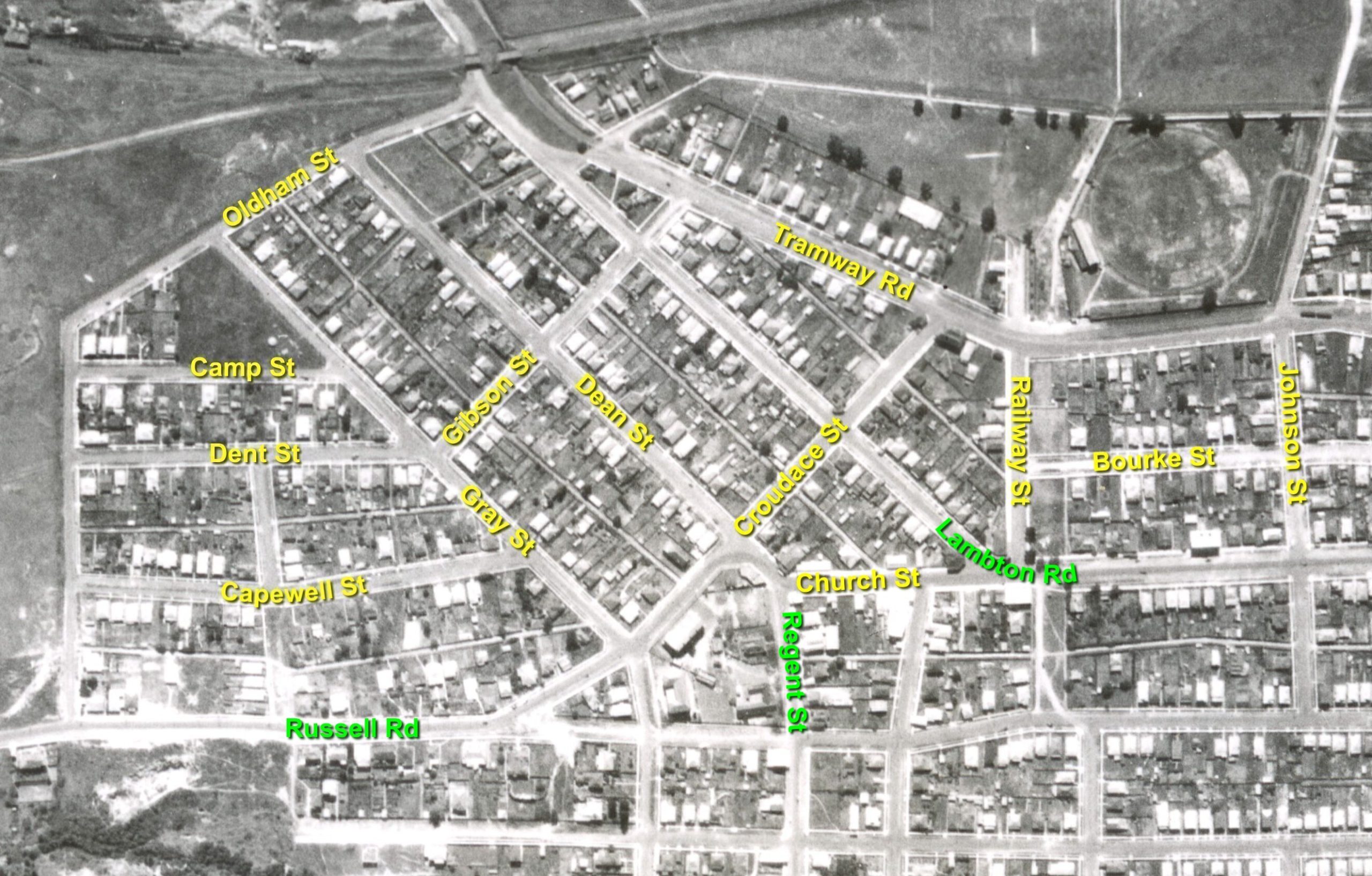
South of Russell Road, the streets appear to have been named by Brown’s “New Lambton Land & Coal Company.” North of Russell Road, streets were named by the new council, mostly after aldermen and employees. But in 1891 the council was dismayed to learn that the Lands Department in Sydney had drawn up a new plan with new street names. The council objected to the expense and inconvenience of having to update their records. At an 1892 council meeting, the clerk reported “having met with the Under-Secretary for Lands, on the subject of the alteration of names of Commonage streets, when it was found that the matter had been sadly bungled by the department, and could not be remedied now, and that the council must adopt the names as they appeared on the departmental plans.” Probably the only maps marked with the 1889-1892 street names were destroyed when the New Lambton council chambers burned down in 1931. However, reports from early council meetings contain enough information to match them to the department’s ‘bungled’ street names we know today.
The article above was first published in the June 2023 edition of The Local.
Additional Information
I have not seen any maps that show the 1889-1892 street names, and as mentioned in the article it is probable that all such maps were destroyed when New Lambton Council Chambers burned to the ground on 16 April 1931. Identifying which streets had which names is a matter of trawling through all mentions of the street name in contemporary newspaper reports in Trove.
- Some streets can be matched by reference to buildings or infrastructure. e.g. Church St, Tramway Rd
- Some streets are clearly identified when named by the council e.g. “That the street commencing at the road near the Primitive Methodist Church, bearing north west to the street following the Lambton Company’s fence be called Dean street.” NMH 16 August 1889
- Some streets can only be identified by a process of logical reasoning. e.g. the council resolution from 15 July 1891 “that Capewell-street be formed, from Gray street to Baker-street” tells us how these streets intersect. With enough references like this, the map can eventually be reconstructed.
A summary of the references to the old street names can be viewed in this spreadsheet. Cells with a yellow background show the first time a street name is referenced. The spreadsheet shows that the transition from the 1889-1892 names to the current names mostly happened in a three month period from July 1892 to October 1892. This lines up with the August 1892 report of the edict from the Under-Secretary of Land that the council must adopt the new names.

Of the 13 old street names annotated in the map accompanying this article, the probable inspiration for the name can be reasonably guessed for most of them.
| Street | Probable source of name |
| Bourke St | Thomas Bourke, valuer for New Lambton Council, 1890 |
| Camp St | ? |
| Capewell St | William Capewell, New Lambton alderman 1890-1892. |
| Church St | The Primitive Methodist Church and Lay Methodist Church were located on opposite sides of this street. |
| Croudace St | Thomas Croudace, New Lambton alderman 1889-1894. |
| Dean St | John Dean, New Lambton alderman 1889-1891. |
| Dent St | William Dent, auditor for New Lambton Council. |
| Gibson St | Samuel Gibson, New Lambton alderman 1889. |
| Gray St | Michael Gray, New Lambton alderman 1889-1890. |
| Johnson St | William Johnson, New Lambton alderman 1889-1892. |
| Oldham St | Joseph William Oldham, New Lambton alderman 1889-1890, works foreman 1891-1893. |
| Railway St | Adjacent to New Lambton colliery railway. |
| Tramway Rd | Newcastle to Wallsend tramway ran along this road. |
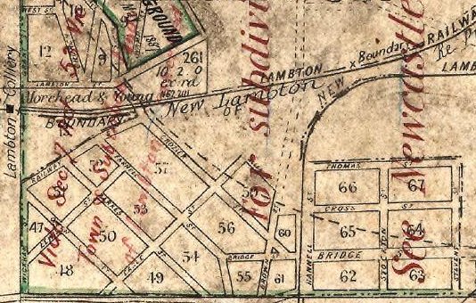
To add to the confusion of street names in New Lambton, the Historical Records Land Viewer site has a parish map from 1884 with a yet another set of names for the streets north of Russell Rd. The street names listed on this map are
- Railway St
- Lewis St
- Cable (?) St
- Crozier St
- Parnell St
- Parkes St
- Owen St?
- Bridge St
- Thomas St
- Cross St
- Hannell St
- Stockton St
- Stevens St
- Brown St
Newspaper articles
| Article Date Event Date | Notes |
|---|---|
| 18 Jul 1891 | "The Government had altered the names of the streets upon the new plan, and he recommended that they be asked to reconsider the question, as it would necessitate the council's books and plans all being altered." |