Often the artefacts of local history are plainly seen in old buildings or monuments around us, but sometimes history lies unnoticed at our feet. A few months ago, in the back streets of New Lambton, I spotted some old stones in the kerb. What at first appeared to be foundations for a corner shop veranda, turned out to be much more significant – rare examples of the 1888 Commonage street alignment stones.
The Commonage was reserved by the government in 1850 for the purpose of pasturing stock before shipping from the port of Newcastle. It consisted of 1600 acres stretching from Waratah to Adamstown, from Lambton to Hamilton. With the development of nearby collieries many miners erected homes on the Commonage even though it was Crown land. After decades of debate and confusion the government decided to pass legislation to allow people to purchase the land they were occupying.
Before land could be sold however, an accurate survey was needed to mark the alignment of streets and property boundaries. A municipal conference in February 1888 agreed “to use stone blocks for alignment marks instead of wooden posts, on account of the damage done to posts by white ants.” The survey work budgeted for 1400 stones to be placed at street corners, with the colonial government and local councils sharing the cost. Each stone protruded a foot above the ground, was 9 inches square, and had a small hole in the centre to position a surveyor’s pole. Over time most of the stones have been removed due to kerb upgrades or replaced with modern survey marks, and only 49 stones remain today. These are significant relics of an important turning point in Newcastle’s history, when a large tract of land close to the city was opened for private ownership and development. The Broadmeadow Place Strategy endorsed by Newcastle Council in 2025 aims to establish 20,000 new homes, mostly within the area marked out with alignment stones in 1888.
The 1600 acres of the Commonage (Newcastle Pasturage Reserve) where the streets were surveyed and aligned in 1888.A few of the remaining Commonage alignment stones.
The article above was first published in the November 2025 edition of The Local.
Additional Information
I first encountered the alignment stones when walking down in New Lambton in July 2025, and noticed two stones on the corner of Wickham Road and Gwydir Road.
Stones on the corner of Wickham Road and Gwydir Road, New Lambton. July 2025.
My first impression was that they were the foundation stones for a street veranda of a corner store, as they looked similar to the veranda stones of the Lambton Cooperative Store. However my research drew a blank on there ever being a store at that location. The nature of these stones remained a mystery until some weeks later, when perusing reports of Lambton Council meetings I stumbled upon the following …
From the Department of Lands, respecting the payment of half cost of the alignment of the commonage. Alderman DENT moved, “That the letter be received and department informed that Council prefer stone alignment marks to wood, and are willing to pay half cost of same when the survey of the commonage could be utilised.”
Researching street alignment stones led me to an interesting paper by Fred de Belin presented to the Association of Public Authority Surveyors Conference in 2014 on “The Big Stone Alignment Posts of Ryde”. The paper contained an excerpt of an old map of Ryde that showed the position of some stones, which raised the question of whether old maps of Newcastle also had maps that showed alignment stones?
The University of Newcastle Living Histories site has a collection of old Water Board maps, and checking the map for New Lambton showed that the stones I had found in Wickham Road, were indeed marked with a dot annotated “A.S.”
In a custom Google Map I added a place-mark at each location where the water board maps had indicated an alignment stone in the Commonage area. Over the course of six weeks I walked the streets and verified where alignment stones still remained. Of the 958 alignment stones marked on the water board maps, I found only 49 remain – a survival rate of 5%.
In the map below, the stone locations are split into three separate layers …
Extant (green) – The stone still exists in place.
Remnant (yellow) – There is some evidence of where the stone once was, or there is a modern survey mark in its place.
Missing (red) – The stone has been removed or is not visible.
The numbering of the stone place-marks is in the form “SheetNumber-StoneNumber”. For example “211-14” is the 14th stone marked on sheet 211 of the water board maps.
It is not clear exactly how many alignment stones were placed in the Commonage originally. At a municipal conference in February 1888, a letter tabled from the Lands Department stated that …
… alignment posts should be put in their proper position at an estimated cost of 15s per post, equal to £1050 for the whole subdivision.
This costing implies that up to 1400 alignment points were planned. The fact that the water board maps have only 958 stones marked is probably due to some of the original 1888 stones having been removed by the time the maps were last updated in the 1910s.
The surveying and placement of the stones in the commonage in 1888 was not without incident. Ralph Snowball, who lived in Clarence Road New Lambton, wrote to the newspaper complaining of the surveyors’ work.
I wish, through the columns of your valuable journal, to draw attention to the manner in which a party of surveyors are executing their work on the New Lambton Commonage. The parties who previously surveyed went though the whole of the work in this particular district and unduly interfered with no fence, trees, etc. But it seems in the majority of instances that I have heard, and my own in particular, that surveyors must go straight through gardens and not have to enter by the usual mode, namely, by the gate, but take their feet or an axe and knock down palings, and leave them off when they go away for goats and pigs to have a parade, as they have done on three occasions at my place. On the 21st, when I arrived home at 7 p.m., I found a valuable Californian pepper tree lopped and mutilated on one side in a disgraceful manner, and, as I keep the branches clear on this of the roof of the verandah owing to wind blowing them, and so making a noise on the iron roof, and the height of the surveyor’s tripod, with theodolite, being not more than 5 feet 6 inches, or 6 feet when set, and also being set within 15 or 20 feet from said tree-I cannot see any reason why it had to be cut nearly to the top of the tree, which is 20 feet or more in height. It was not previously in the road of other surveyors. There is also the annoyance caused by their being two or three hours around close to the house talking, &c., and my wife lying very ill with typhoid fever. Had I been at home I should certainly have tried to get them to act in a more manly way, and leave the fences, &c., as they found them, especially when no one belonging to the house was there to replace the palings, &c.
Lambton Council in a meeting in March 1888 also complained about the placement of stones.
The report of March 20 drew attention to the placing of stone alignment posts on the Commonage, some of them far into the macadamised roadway, and as they were placed a foot above the surface they ran the risk of being smashed. One of them was smashed on Saturday by a three-horse dray colliding with it. He suggested that a yard of broken metal be placed around the stones wherever so exposed.
Newcastle Morning Herald and Miners’ Advocate, 22 March 1888.
The Mayor [of Adamstown] stated that the alignment posts had been placed in position by the surveyor. He expressed his displeasure at the way a number of the street ends had been left.
Quite a few alignment stones still exist in Adamstown, south of Brunker Road.
A street alignment stone in Victoria Street, Adamstown.
New Lambton Council was incorporated on 9 January 1889, and subsequently set about getting their streets surveyed and aligned. There is a mention in September 1890 of “alignment posts” (presumably wooden) and then a mention of “alignment stones” in December 1892. There are still a few alignment stones in the streets of New Lambton, south of Russell Road.
A street alignment stone in Evescourt Road, New Lambton.
Waratah Council was incorporated on 23 February 1871 and had street alignment posts in place well before the Commonage was surveyed in 1888. Water board map Sheet 208 shows that survey marks in Waratah streets were labelled with “A.P.”, presumably meaning “Alignment Post”.
Alignment posts marked at the corner of High and Bridge Streets, Waratah.Alignment posts at the corner of High and Bridge Streets, Waratah, c. 1885-1888. Photo by Ralph Snowball. University of Newcastle, Living Histories.
Letter to Lambton Council from the Department of Lands, respecting the payment of half cost of the alignment of the commonage. Alderman DENT moved, "That the letter be received and department informed that Council prefer stone alignment marks to wood, and are willing to pay half cost of same when the survey of the commonage could be utilised."
"Surveyors are now busy at work on the commonages cutting it up into suitable allotments, with a probable view to early disposal. If the terms of sale are fixed at reasonable rates and present holders have preferential rights accorded them, then the satisfactory settlement of a long-standing trouble will be hailed with delight."
Municipal conference: "It is proposed that as the subdivision progresses, alignment posts should be put in their proper position at an estimated cost of 15s per post, equal to £1050 for the whole subdivision." (This costing implies that there were 1400 alignment posts. ) "The Councils interested recommend to the Minister for Lands the advisability, while aligning the streets of the Commonage to use stone blocks for alignment marks instead of wooden posts, on account of the damage done to the posts by the white ants."
Thomas Frith, candidate for Adamstown council elections "referred to the alignment of the streets on the Commonage, and said that if the Government had the power to sell the Common, they should pay for the alignment, and let the rates derived from the property go towards improving the streets of the Commonage."
"The work of surveying the Commonage previous to its disposal to the present occupants is proceeding. The surveyors have, in many instances, laid the streets out so that they take the lines as at present occupied by the houses, and which, if carried out, will necessitate the removal of the structures."
"A deputation, representing a conference of delegates from Adamstown, Hamilton, Lambton, and Waratah Municipal Councils, waited on the Minister for Lands in connection with the alignment of streets." The minister "would agree to the erection of stone pillars instead of wooden posts.”
Waratah Council: Letter "from the Lands Department, stating that the district surveyor has been authorised to obtain about 350 alignment posts (stating dimensions), price not to exceed 3s each, for the alignment of streets in the sub-division of the Newcastle Pasturage Reserve. Stone could be used instead of posts, if Council desired."
Adamstown Council meeting: "The clerk stated that he had been informed by one of the surveyors that he had been instructed to survey Adamstown along with the commonage."
Adamstown Council: “The Mayor reported having waited upon Mr. Surveyor Halworth re alignment marks, and submitted two designs for the consideration of the aldermen. After a deal of talk it was resolved, on the motion of Alderman Weir, that the alignment marks be stone, one foot high.”
Adamstown council: "The MAYOR stated that the alignment posts had been placed in position by the surveyor. He expressed his displeasure at the way a number of the street ends had been left."
East Lambton Progress Association: "It was also decided to write to Newcastle Council asking that the alignment stones at the corner of Karoola and Durham Roads be removed and not placed back on the footpath as suggested by the council."
This list covers hotels that were located in the area of New Lambton Municipal Council (1889-1938), shown by the white border in the image below. The current suburb of New Lambton is shaded in yellow. Note that the northernmost tip of the New Lambton municipality included a small part of present day Broadmeadow, which is why the Sunnyside Hotel is included in this page of New Lambton hotels.
Area of New Lambton Municipality (1889-1938) bordered in white, with present day suburb of New Lambton shaded with yellow.
The map below shows the location of Lambton Hotels. The four hotels that are still operating are shown in green, historical hotels are shown in red.
Timeline of New Lambton Hotels.
In documenting the history of hotels it is important to understand the roles of owners, lessees and licensees. The hotel owner is the person (or company) that owns the land and buildings upon the land. The owner may then lease the buildings to another person (or company) for the purpose of running a business such as a hotel. The hotel licensee is the person who is granted a liquor license by the government and is responsible for adhering to the liquor regulations. Sometimes the owner and licensee are the same person, but sometimes the owner, lessee and licensee are three different entities. For example, in 1878 for the New Lambton Hotel, the land was owned by the New Lambton Company, leased to Joseph Chinchen, and the hotel licensee was Enoch Davies.
The history of hotels can also be confusing in that the same hotel can have different names over time. For example, the Kotara Hotel was renamed to the Blackbutt Hotel in 1978. Sometimes a hotel name and license can be transferred to a different geographical location. For example, the Sportsman’s Arms Hotel first opened on Regent Street in 1870, but then moved to Hobart Road in 1903.
A further complication is the variant spellings of the licensee names. Where there are multiple spellings of a name and the correct spelling is uncertain, I have included variant spellings in square brackets. e.g. “Damerell [Damerill]”. Note that in the lists of licensees I have only included names up to about 1970, as online information about licensees after this date becomes sparse.
In the list below I have an entry for each hotel operating at a specific location. The hotels appear in order of the year they were first opened.
New Lambton Hotel (1869-1879)
The first hotel in New Lambton was the somewhat unimaginatively named “New Lambton Hotel”. It was erected on the south-west corner of Russell Rd and Regent St by Mr Hubbard of Hunter St Newcastle.
On our way home from the foot races, at Lambton, on Saturday last, we had an opportunity of paying a visit to the New Lambton Hotel, recently erected by Mr. Hubbard, of Hunter-Street. The building in question is certainly an excellent one, and, in every way, well adapted to the requirements of the place. The expeditious manner in which this hotel was put up is worthy, of notice. Less than four months ago, from the present time, the ground on which it stands was a wild, uncleared bush ; and the hotel has been open for nearly a month, so that, as a matter of fact, the hotel was only three months in course of erection. Of course this would be nothing out of the way if the site had been an accessible one — which it was not — the road to New Lambton being about as bad a one as there is in the whole district, and that is saying a good deal. The building is a two-story one, and appears to be well and faithfully built. It is nicely painted inside and out, and is really a very snug and comfortable place. The bar is commodious and airy, and in regard to attractiveness is not surpassed by any establishment in the city of Newcastle. On the upper floor of the hotel there is a large room, well adapted for public meetings and entertainments, and at the rear of the premises are stables to accommodate an almost unlimited number of horses. Altogether, the New Lambton Hotel is one of the very best hotels in any of the colliery townships.
Henry Lott, the first licensee of the hotel, was granted a publican’s licence in July 1869. His tenure at the hotel did not last long, only 9 months later in March 1870, the lessees (Hubbard and Chinchen) advertised for sale, the “license, stock, and furniture of the New Lambton Hotel.”
In May 1870 John Gordon announced in a large advertisement that he had taken on the New Lambton Hotel. His tenure was similarly short-lived and by March 1871 Hubbard and Chinchen were once again advertising the hotel for letting.
David Lewis was issued a publican’s licence commencing on 1 July 1871, followed by George Lowe who held the licence from 1 July 1874. In May 1875 George Lowe advertised “a sale by auction for household furniture and effects” at the New Lambton Hotel.
Thomas Hardy was issued the publican’s licence from 1 July 1875. In December 1876 the hotel had a narrow escape from being burned down, when a hanging kerosene lamp, without any apparent cause, suddenly exploded and splashed burning oil on the floor. Only the quick action of Thomas Hardy’s daughter in smothering the flames with a blanket prevented a serious conflagration.
In April 1877 the newspaper reported that the hotel was “about to change hands from Mr T Hardy to Mr Enoch Davies”. At a Police Court hearing in June 1880 “the license of the New Lambton Hotel, New Lambton, was cancelled, as the proprietor, Mr. Enoch Davis, was proved to have abandoned his licensed house.”
There is a final reference to the hotel on 15 October 1880, with an advertisement noting that “Mr T M Dalveen will address the electors … at the New Lambton Hotel”. As there is no evidence of any licensees after Enoch Davies cancellation, I can only assume that this is a reference to the hotel building, not the hotel as a licensed premises.
An article in September 1892 states that after the hotel was no longer licenced, the building was “used as a store and temperance hall.” Mentions of a Temperance Hall in New Lambton start appearing in Trove from September 1880, just a few months after the licence was removed.
There are no known photographs of the original hotel and Temperance Hall building, and the date of demolition is uncertain. The brick building that now occupies the site appears to be 1920s era.
Site of the New Lambton Hotel (1869-1880) in March 2025,
Location
An 1877 map relating to the proposed site for New Lambton public school shows the New Lambton Hotel on the south-west corner of Russell Rd and Regent St.
Map reproduced from the New Lambton Public School (1880-1980) Centenary booklet.
The following information, also supports this location.
16 September 1869 article says it was “within a few yards” of Lunn’s Hand of Friendship Hotel south-east corner of Russell Rd and Regent St)
16 April 1878 advertisement for lease of New Lambton Hotel, applications to J Chinchen. An 1886 New Lambton Subdivision map shows that Lots 5 and 6 were leased to “Chinchin”, and Land Title Vol-Fol 1048-80 shows Lot 5 of Sec C passed into Ellen Chinchen’s ownership in 1892.
21 April 1951 article mentions “Lathlean’s Temperance Hall, a building on the corner of Russell and Regent Streets that had been a hotel.” Land Title record Vol-Fol 1048-80 shows Lot 5 of Sec C was owned by Richard Lathlean from 1892 to 1907.
1886 subdivision map showing Chinchin’s [sic] lease in Section C and Lunn’s lease in Section D.
The Hand of Friendship Hotel was opened on 18 September 1869, its first publican Benjamin Lunn pledging in an advertisement the sale of “none but the very best wines, spirits, ales etc.” The premises also offered “abundant accommodation for the requirements of a colliery township.“
Advertisement for the opening of the Hand of Friendship Hotel. Newcastle Chronicle, 18 September 1869.
It was just the second hotel to open in New Lambton. Benjamin Lunn remained the publican until his death in 1878 when the hotel passed to his wife Jane, and later to their son James in 1884.
In November 1894, a stable in the course of erection at the hotel collapsed in a strong wind. Three children were injured, including the six year old daughter of the publican, George Masters, who had her leg badly fractured below the knee. Ralph Snowball photographed the hotel in September 1895, and the group standing at the door is almost certainly the publican of the day, George Masters, with his wife and two daughters. It is probable that the little girl on the right is the daughter who was injured in the accident the previous year.
The name of the publican “G. Masters” can be partially seen in a sign above the door, behind the lamp.
Snowball photographed the hotel again in 1903, with a larger group of people out the front.
Hand of Friendship Hotel, 2nd May 1903. Part of the Centenary Hall can be seen behind the hotel, at the left side of the photo. Photo by Ralph Snowball. University of Newcastle, Living Histories.
The diagonal writing in the three panels below the name says:
Licensed to retail | Fermented l(iquors) | Spirituous liquors
The publican at this time was Phillip James Byrne, having acquired the license from Edmund Butterworth three months earlier in February 1903. Note in the sign above the door there is a faint H at the end, which is probably the remnants of the name of the previous licensee.
In June 1903, just a month after Snowball’s photograph was taken, the application of Phillip James Byrne for a renewal of the license was objected to on on the grounds that “the accommodation was inadequate, and the place in an insanitary condition.” Despite the objection the renewal was granted for another year.
In 1905, with further deterioration, the police opposed the renewal of the hotel’s licence “on the ground that the building was in bad condition, owing to the white ants.” It survived that objection, but only for another year. Plans to demolish the building and erect a new hotel came to nothing, and in 1906 John Canning, the last publican to stand behind the bar of the Hand of Friendship Hotel, relinquished his licence.
The building stood idle for some time before it was sold, when it gained a new life as a second-hand goods shop. The weathering of the years however was relentless. In 1933 the building was finally demolished.
Demolition of the former Hand Of Friendship Hotel building in 1933.The site of the former Hand of Friendship Hotel, corner of Russell Rd and Regent St in New Lambton. March 2025.
Location
An 1877 map relating to the proposed site for New Lambton public school shows the Hand of Friendship Hotel on the south-east corner of Russell Rd and Regent St.
Map reproduced from the New Lambton Public School (1880-1980) Centenary booklet.A 1917 Water Board map shows the former Hand of Friendship Hotel building. University of Newcastle, Living Histories.Site of the Hand of Friendship Hotel and Centenary Hall, New Lambton.
Centenary Hall
In 1906 the hotel ceased to trade, and in January 1907, the owners of the building, Tooth and Co., put the property up for sale. The sale included the land, hotel building, and the Centenary Hall adjacent to the hotel and fronting Russell Rd. The land was described as having frontage of 133ft 4in to Russell St, and 98ft 3in to Regent St.
The following is a list of licensees as gleaned from various mentions in newspaper articles over the years. Some of the dates are known with certainty, as there is a report of the license being transferred from one person to another. For some licensees I have had to make an informed estimate based on the first and last reported association of the licensee with the hotel.
George Bertram Bowser (October 1906 to November 1906)
The 1933 article on the demolition of the building states that “Ben Bradley (afterwards an alderman in the New Lambton Council)” was also a licensee, but I can find no independent evidence for this. Benjamin Bradley did have a publican’s license at one stage, but it was for the Lake Macquarie Hotel in Teralba.
The article also states that Jack Canning “was the last to stand behind the bar of the old hotel”. Although this is true, he wasn’t the last licensee. George Bertram Bowser was the final licensee, for just under a month in October/November 1906. The report on the cancellation of his licence in November 1906 however, makes it clear that the building remained unoccupied during his short tenure as publican.
A general article describing the beginnings of New Lambton, that notes that the Hand of Friendship Hotel is the second hotel in the township. "Both these houses afford abundant accommodation for the requirements of a colliery township."
Reference in a court hearing to "James Lunn, hotelkeeper, at New Lambton". Although the hotel is not named, it is presumed that it the Hand of Friendship hotel.
The roof of a stable in the course of erection at the Hand of Friendship Hotel is blown off by a strong gust of wind. The building then collapsed and three children are injured, including the six year old daughter of the publican, George Masters, who had her leg badly fractured below the knee.
Advertisement. "FREE Public Dance, Monday Night, Butterworth's Centenary. Hall, New Lambton. Noble and Gaggetta, Musicians." The Centenary Hall was part of the Hand of Friendship Hotel site.
"The application of Phillip James Byrne for a renewal of the license of the Hand of Friendship Hotel, New Lambton, was objected to on a report, furnished by Sergeant G. Salter, to the effect that the accommodation was inadequate, and the place in an insanitary condition."
"John Canning, Hand of Friendship Hotel, New Lambton, applied for renewal of license. The police opposed the application on the ground that the building was in a bad condition, owing to the white ants. Mr. T. A. Braye (Messrs. Braye and Cohen) appeared for the applicant and said that plans had been prepared for a new building, which would be erected. Temporary improvements would also be made. Michael Joseph Moroney, representing the owners, Tooth and Co., confirmed this statement, and the renewal was granted."
Plans to build a new hotel on the site of the Hand of Friendship Hotel … "the firm of Tooth and Co. contemplate erecting a large hotel on the present site of their hotel property, situated at the corner of Regent-street and Russell-road."
LICENSING COURT. The following transfers were approved :- From John Canning to George Bertram Bowser, Hand of Friendship Hotel, New Lambton, and from Thomas Mclntosh to John Canning, Sportsman's Arms, New Lambton.
"In the matter of the Hand of Friendship Hotel, New Lambton, Sub-Inspector Goulder applied for cancellation of the license. The hotel changed hands on October 11, and since that date had remained unoccupied. The license, which was held by W. Bowser, was formally cancelled."
Report on the demolition of the Hand of Friendship Hotel building.
Sportsman’s Arms Hotel (1) (1870-1903)
In a 16 September1869 article on the rapid progress of New Lambton, the Newcastle Chronicle noted there were two hotels already and that “a third public-house is in course of erection, and the proprietor, Mr.Jones [sic], expects a license for it shortly after it is finished.” Just a few months later, on 22 January 1870, Nicholas Johns announced by way of advertisement the opening of the Sportsman’s Arms hotel.
The hotel was located on the north-west corner of Regent St and Portland Pl.
Portion of 1886 subdivision map showing Lot 6 of Section H, location of Sportsman’s Arms Hotel, leased to Nicholas Johns. State Library of NSW.
In 1895, John Thomas purchased from the New Lambton Land and Coal Company, lots 6 and 7 of Section H, where the hotel building was located. Subsequently on 6 May 1899, Marshalls Paddington Brewery Limited purchased the hotel land and building.
Purchase of Sportsman’s Arms Hotel by Marshalls Paddington Brewery Limited, 6 May 1899. Vol-Fol 1172-136
Three years later in July 1902, Marshall’s Brewery commenced plans to construct a new hotel building in Hobart Rd, with the intention of transferring the license of the Sportsman’s Arms to the new premises and closing the original hotel in Regent St. The transfer of the licence to the new location occurred a year later in July 1903. William Thompson, the last licensee at the old location, continued on as licensee at the new premises.
The old Sportsman’s Arms Hotel in Regent-street, which is one of the oldest buildings in the municipality, and in the early days was considered to be among the best of its class, is now closed, the license having been transferred to the new building recently erected by the Marshall’s Brewery Company in Hobart-road.
Newcastle Morning Herald and Miners’ Advocate, 4 Jul 1903.
The old hotel building was occupied as a private dwelling for about two years, but after being vacant for several months a fire destroyed the building in June 1905. There are no known photographs of the original hotel building.
The land was then owned by a number of different people in the next 17 years, and then on 20 November 1922 the Methodist Church purchased the land to erect a church building
Purchase of land by Methodist Church on 20 November 1922. Vol-Fol 1172-136
The New Lambton Uniting Church occupies the site today.
New Lambton Uniting Church, March 2025. Site of the first Sportsman’s Arms Hotel.
Licensees
Nicholas Johns [Jones] (January 1870 to March 1871)
William Thompson (c. July 1902 to June 1903 at Regent St, then continued as licensee at new premises in Hobart Rd)
Sportsman’s Arms Hotel (2) (1903-1987)
On 26 March 1902, William Masefield Bostock advertised …
… that I desire to obtain and will at the next Quarterly Licensing Court to be holden at Newcastle on the Third Day of April Next apply for a Certificate authorising the issue of a Conditional Publican’s License for premises proposed to be erected and situated at the corner of Alma-road and Lambton-road, and to be known by the sign of “Sportsman’s Arms,” and containing eleven rooms, exclusive of those required for the use of the family.
Newcastle Morning Herald and Miners’ Advocate, 26 March 1902.
At the licensing court held on 14 April 1902, Bostock stated …
… that he was an agent for Marshall’s Brewery Company, who had an hotel known as the Sportsman’s Arms Hotel, New Lambton, and he proposed to remove the license of that house to that for which he was applying for a conditional license. He had a guarantee, which he produced, from his company to close the Sportsman’s Arms should the new license be grant ed. The site of the proposed hotel was at the intersection of Alma-road and Lambton-road, opposite Roberts’ store. He did not own the land, but had taken certain steps to procure it.
Newcastle Morning Herald and Miners’ Advocate, 15 April 1902.
After hearing arguments the Bench refused the application “on the ground that the requirements of the place did not justify a license.”
The refused license did not deter the applicants. Foregoing their plans for a hotel on the corner of Alma and Lambton Rd, Marshall’s Brewery purchased lot 1356 on the corner of Hobart and Rugby Roads from William Thompson, and at a hearing on 4 July 1902 resubmitted their application for a conditional license. The police lodged an objection “on the ground that the requirements of the place did not justify the issue of a license”, the bench deferred their decision to a later hearing. After visiting the New Lambton and inspecting the existing hotels, and the site of proposed new hotel, the licensing bench granted the conditional license on 15 July 1902.
In April 1903 the newspaper reported that …
A large brick hotel is now being erected for Mr. Thomson overlooking the reserve, close to the tram terminus. The roof which is of red tiles, is now completed, and the contractor, Mr. Viggers. is busy finishing the interior to the designs of Mr. Henderson, architect.
Newcastle Morning Herald and Miners’ Advocate, 17 April 1903.
The new hotel opened for business just a few months later in July 1903.
The old Sportsman’s Arms Hotel in Regent-street, which is one of the oldest buildings in the municipality, and in the early days was considered to be among the best of its class, is now closed, the license having been transferred to the new building recently erected by the Marshall’s Brewery Company in Hobart-road.
Newcastle Morning Herald and Miners’ Advocate, 4 July 1903
Lot 1356 of the Newcastle Pasturage Reserve was formally purchased by Marshalls Paddington Brewery Limited, on 10 October 1902. Vol-Fol 1422-132
Photos from the from the Sportsman’s Arms Hotel ‘yellow cards’ in the ANU Open Research Repository shows that the exterior of the hotel remained largely unchanged during its lifetime.
The Wests Leagues Club purchased the Sportsman’s Arms hotel in 1987 and demolished it to enable an extension of their club premises.
The site of the former Sportsman’s Arms Hotel, corner of Hobart Rd and Rugby in New Lambton. March 2025.
Commonwealth Hall
William Thompson, on the same day that he had purchased the land for the new Sportsman’s Arms Hotel, also bought another block of land on Hobart Rd. (Lot 1349,Vol-Fol 1750-42.) In 1903 Thompson erected a hall on this land, naming it the Commonwealth Hall, which was formally opened at a Fire Brigade social on 16 October 1903.
The Mayor (Alderman Errington), on behalf of the proprietors, declared the hall open. In doing so he explained that the building was to be known as the Commonwealth Hall. Alderman Errington referred to the rapid progress New Lambton was making, and said the building just completed, besides being an ornament, would be a valuable addition to the town.
Sportsman’s Arms Hotel and Commonwealth Hotel appear in a New Lambton panorama by Ralph Snowball. University of Newcastle, Living Histories.The name “Commonwealth Hall” can barely be discerned on the front of the building.A Newcastle Pasturage Reserve map overlaid into Google Earth, showing the location of the Commonwealth Hall on lot 1349.
In 1912 the licensee of the Belmont Hotel, John Sperring, purchased the hall and in July 1912 advertised that …
TENDERS are invited for taking down the Commonwealth Hall, situated at New Lambton, Removing, and Erecting at Belmont.
Newcastle Morning Herald and Miners’ Advocate, 6 July 1912.
A newspaper article in December 1913 spruiking the pleasures of Belmont noted that
The town possesses accommodation in the way of halls for entertainment, and within the past year Mr. Sperring, licensee of the Belmont Hotel, has erected a large hall adjoining the hotel grounds. The building is 70 feet long by 30 feet wide, and will seat comfortably about 500 persons. It has a large stage capable of mounting big acts. and the floor is well adapted for dancing. The building was previously the Commonwealth Hall at New Lambton, which Mr. Sperring purchased, and had re-erected, strengthened, and generally improved in its interior decorations. The hall is frequently used by moonlight excursion parties.
Note that Sperring’s Belmont Hotel is not the modern day Belmont Hotel in Hitchcock Avenue. There was an earlier Belmont Hotel on the west side of the Pacific Highway, opposite George Street. In the photograph below from the Lake Macquarie History site, the building to the left of the hotel is probably the re-erected Commonwealth Hall.
Mrs Catherine Anne Ruggeri (April 1950 to November 1957)
William Henry Murphy (November 1957 to July 1959)
William Smoker Boyling (July 1959 to April 1963)
Horace William Box (April 1963 to March 1965)
William Edward Compton (March 1965 to December 1978)
Roy Raymond Beverly (December 1978 to ????)
Nil Desperandum Hotel / Duckenfield Hotel (1876-1880)
The Nil Desperandum was New Lambton’s shortest-lived hotel, operating for just four years from July 1876 to June 1880. There are no known photographs of the hotel. The first mention of the hotel in the newspaper was a short notice on 15 July 1876 advising that …
Mr. Edgar Ashley [sic] has opened his new hotel under the name of Nil Desperandum.
Newcastle Morning Herald and Miners’ Advocate, 15 July 1876.
and on the same day an advertisement seeking a servant.
WANTED, a Female General Servant, one accustomed to a Public House. Apply Mrs. E. ASHBY, Nil Desperandum Hotel, New Lambton
Newcastle Morning Herald and Miners’ Advocate, 15 July 1876.
The Government Gazette of publican licenses for the year commencing 1 July 1876 lists Edgar William Ashby as the licensee of the Nil Desperandum Hotel, Griffen-street, New Lambton. Griffen Street (or more correctly Griffin) was the original name for what later became Victoria Street. The hotel was located on the south-west corner of Victoria and Cromwell Streets, on land leased by Thomas Sneddon (sometimes spelled Sneddan) from the New Lambton Coal Company.
1886 New Lambton subdivision map, showing Sneddan’s Lease on Griffin Street (Lots 1-4, Section G). State Library of NSW.
In 1878 Edgar Ashby constructed a music hall on land adjoining the hotel, and formally opened the hall on 21 May 1878.
Mr. Ashby, landlord of the Nil Desperandum, has, at a considerable cost, erected a fine hall adjoining his hotel. The building is 36 feet by 24 feet, and is to be fitted up for all kinds of public entertainments and meetings. This is a want which has long been felt by the people of New Lambton, and especially the miners, who have never had a proper place to meet in. The hall is to be opened on Tuesday, the 21st inst., by a grand ball and supper.
Newcastle Morning Herald and Miners’ Advocate, 14 May 1878.
We are left to wonder about the details, but something was awry in the Ashby family. Edgar Ashby place the following advertisement in July 1879.
I EDGAR ASHBY, of New Lambton, will not be responsible for any debts contracted by my wife, JANE ASHBY, from this date.
Newcastle Morning Herald and Miners’ Advocate, 25 July 1879.
The following month the license of the hotel changed hands, with an advertisement on 21 August 1879 announcing that …
HENRY DOHERTY, (LATE OF THE RACE HORSE INN, LAMBTON), HAVING TAKEN THE NIL DESPERANDUM HOTEL, New Lambton, hopes, by keeping the BEST BRANDS of Wines, Spirits, and Ales, to merit a fair share of the public patronage.
Newcastle Morning Herald and Miners’ Advocate, 21 August 1879.
The new licensee also took over the operation of the adjoining hall, and there a few references to “Doherty’s Hall” in 1878 and 1879. On 11 June 1880, Henry Doherty advertised for sale “the Lease, License, Furniture, and Stock” of his hotel in New Lambton. There appears to have been no takers on this offer from the licensee (Henry Doherty), and 17 days later the lessee (Thomas Snedden) was advertising the hotel for rent.
TO LET, the Nil Desperandum Hotel, New Lambton, with Concert Hall, and every convenience. Rent moderate. Apply to THOMAS SNEDDEN, Storekeeper, New Lambton.
Newcastle Morning Herald and Miners’ Advocate, 28 June 1880.
This advertisement also seems to have been met with a stony silence, for there is no further mention of the hotel as a going concern. The hotel building was demolished in 1937 and the music hall demolished in 1949.
In Cromwell-street, New Lambton Mr. S. Bagnall spent the week completing the demolition of a building. Casual passers-by might have thought it was just a garage that had served its. day, but old stagers knew it was more than that. It was one of the district’s oldest private halls. There was scarcely room to swing a hip, if you gauged by modern standards, for the wooden hall was only 40 by 26 feet. The hall was part of the Nil Desperandum Inn, which stood on the corner of Cromwell and Victoria Streets. It was run by the innkeeper, Mr. Tom Sneddon, sen., a native of Dalkeith, Scotland.
At the back of both buildings the innkeeper planted a small forest of camellia trees. About 100 trees remain, 70 to 80 years old, still blossoming and supplying city florists.
Somewhere along the years the inn was closed and became a private residence for Mr. and Mrs. Sneddon and their children-two boys and two girls. The bar was partitioned off and let as a doctor’s surgery. The dance hall was also closed. It was used to store the odds and ends that in houses with attics are usually hidden in the ceilings. In 1937 the inn was demolished, but the hall remained. Soon, all that will remain of the Nil Desperandum and its hall will be the camellia forest and the inn’s 20ft. well.
Newcastle Morning Herald and Miners’ Advocate, 1 October 1949.
1917 Water Board map showing the former Nil Desperandum hotel building (yellow) and the music hall (green). Composite of maps 246 and 247, University of Newcastle, Living Histories.
A 1938 aerial photo of New Lambton shows an empty space on the corner where the hotel building was demolished the year before. The hall and the camellia garden at the rear is still visible.
The site of the former Nil Desperandum Hotel, corner of Victoria and Cromwell St in New Lambton. March 2025.
Duckenfield Hotel
Between 1877 and 1880 there are a handful of references to a “Duckenfield Hotel” in New Lambton. While there is no definitive proof, the available evidence strongly suggests that this was the Nil Desperandum hotel trading with a different name.
All the references to the Duckenfield Hotel (1877 to 1880) are in the same range of years for the Nil Desperandum Hotel (1876 to 1880)
There are no references where both hotels are mentioned together, which would conclusively prove they were different hotels. Crucially, the Government Gazette licensee lists in this period only ever contain one of the two names, and always on the same street, with the same licensee.
1876 – Edgar William Ashby, Nil Desperandum, Griffen St
1877 – Edgar William Ashby, Duckenfield, Griffen St
1878 – Edgar William Ashby, Duckenfield, Griffin St
1879 – Edgar William Ashby, Duckenfield, Griffin St
In August 1879 Henry Doherty advertised his taking over of the Nil Desperandum Hotel, but just four months later in December 1879 there is a reference to “Doherty’s Duckenfield Hotel”.
In June 1880 there are two references to a hotel in New Lambton being up for lease – Doherty’s Duckenfield Hotel on 11 June 1880, and the Nil Desperandum Hotel on 28 June 1880. Neither hotel is heard of again. It seems highly unlikely that two different hotels on the same street would disappear from the records in the same month.
The Duke of Wellington hotel was first introduced to the public in a brief article of New Lambton news on 15 July 1876 that mentions that …
… another [new hotel] will shortly be opened by Mr. D.Jones.
The Government Gazette of publicans’ licenses issued for the year commencing 1 July 1876 has an entry for “David Jones, Duke of Wellington Hotel, Horsefield-street, New Lambton.” Horsfield Street was the original name for Regent Street, and the hotel was located at its present site on the corner of Regent Street and Portland Place, on Lot 6 of Section 6, which was leased by the New Lambton Coal Company to Abraham Butterworth. Abraham Butterworth was the second licensee of the hotel, for a brief period from April 1878 to February 1879.
The first photograph of the Duke of Wellington Hotel dates from the time of the eighth licensee, Joseph Garratt (1887 to 1895). The photo shows a very basic weatherboard building, as were all the early New Lambton hotels. This was because up until about 1886 the New Lambton Coal Company did not sell any of their land for housing or businesses, but only provided 14 year leases. Naturally, residents and businessmen were reluctant to build any substantial structures on land they did not own or control in the long term. As a consequence, in contrast to neighbouring Lambton, no substantial building in New Lambton from the 19th century has survived to the present day.
After the New Lambton Coal Company started selling land, Abraham Butterworth purchased the Duke of Wellington building and land in 1891. (Vol-Fol 1006-20)
In 1898 George Burt made improvements and additions to the hotel.
Among the number of new buildings lately erected in this municipality are the improvements and additions made at Burt’s Duke of Wellington Hotel. Particular attention has been given to make the alterations roomy, with plenty of ventilation, and a good height, the bar and parlours being very noticeable in this respect. A staircase 3ft wide leads to the hall, 16 x 32, which is intended for a lodge or supper room.
Newcastle Morning Herald and Miners’ Advocate, 6 June 1898.
In 1919 Abraham Butterworth sold the property to the Castlemaine Brewery and Wood Brothers. (Vol-Fol 1006-20, p2). In August 1921, at a Licensing Court hearing …
Permission was given to Paul Turnbull, licensee of the Duke of Wellington Hotel, New Lambton, to erect a new brick building.
The fittings, fixtures and timbers of the old hotel building were put up for auction on Saturday 10 September 1921. Strangely for such a major project, the newspaper contains no reports on the demolition of the old building, or the construction and re-opening of the new building. A photo from 1924 shows the building with clean sharp brickwork and the year “A.D. 1921” prominently displayed on the corner facade.
In September 1954, Pitt & Pitt architects called for “tenders for extensive alterations and additions, to Duke of Wellington Hotel for Tooth & Co.” Presumably these were the alterations that ‘modernised’ the exterior, and arguably denuded the building of its 1920s architectural charm.
The Sunnyside Tavern is located in Broadmeadow Rd, Broadmeadow. I have included it in this page of New Lambton Hotels, as this location fell within the borders of the New Lambton Municipal Council which operated from 1889 to 1938.
Specifying the location of the Sunnyside has always been problematic, as the names and boundaries of suburbs in this area have changed over time. Here are some examples of the different locality names the hotel has been placed in over the years …
This map of modern suburb boundaries shows that here are four other suburbs within 350 metres of the Sunnyside Tavern in Broadmeadow: Waratah, Georgetown, Hamilton North, and New Lambton.
On 17 June 1884, Michael Fenwick of Waratah, gave notice in an advertisement of his intention to apply at the next Licensing Court for …
… the issue of a Publican’s License for premises situated at Broad Meadows Road, between Waratah and Hamilton, and to be known by the sign of “Sunnyside Inn,” containing six rooms, exclusive of those required for the use of the family.
Newcastle Morning Herald and Miners’ Advocate, 17 June 1884.
Four months later another advertisement announced …
SUNNYSIDE INN, BROAD MEADOW. MICHAEL FENWICK desires to intimate to his many friends and the public that he has OPENED the above NEW INN, and is now prepared to accommodate all who may favour him with a call.
The establishment was equally referred to as the “Sunnyside Inn” and “Sunnyside Hotel” in its first 30 years. There are no known photographs of the first hotel building. In 1903 Joseph Heslop became licensee, and progressed plans for significant renovations to the hotel building.
Tenders are due on Saturday for important extensions to the Sunnyside Hotel, Broadmeadow-road, near Georgetown. It is proposed to add a floor space above at this hotel and have a colonnade. This work will involve an outlay of £500 or £600.
Newcastle Morning Herald and Miners’ Advocate, 2 July 1904.
By October the renovations were well underway.
The Sunnyside Hotel has been pulled down all but four rooms, and a brick two-storey addition erected of twelve rooms, with a colonnade in the centre and balconies on each side. The stable buildings are also to be made in keeping with the hotel, and when all is completed (by Messrs. Bates and Everett, the builders) this will be a well-appointed establishment.
Judging by the shiny corrugated iron roof and crisp paintwork, Ralph Snowball photographed the hotel building not long after the renovations were completed.
Around the time of Joseph Heslop’s tenure and the renovation in 1904, use of the name “Sunnyside Inn” declined, and afterwards it was principally referred to as the “Sunnyside Hotel”.
A 1909 Water Board map shows that an extension had been made at the northern end of the building. This was possibly the stables alluded to in the October 1904 report.
The Sunnyside Hotel is marked on a locality sketch on a 1919 real estate poster for a subdivision of 72 building sites in “Hamilton – Newtown”. University of Newcastle, Living Histories.
In March 1921 Tooth and Co purchased the hotel, and in July 1921“Percy George Phillips, licensee of the Sunnyside Hotel, was granted permission to make alterations and additions to his premises.” The alterations were in progress by December, and completed by April 1922 when the Newcastle Sun reported on the new hotel building.
Residents of the Newcastle district are agreeably surprised when passing through Georgetown at the view of the re-constructed Sunnyside Hotel. The old building which is true was a landmark of this locality, was entirely demolished, and in its stead has been erected a modern hotel of pleasing design. The new premises contain a commodious bar, two parlors, store room, office, public and private dining-rooms, kitchen, pantry and laundry, and the necessary lavatory; accommodation on the ground floor and on the first floor there are 14 bedrooms, sitting-room, two bathrooms, linen cupboards, and other conveniences. The outside walls are tiled up to height of the sill, and a suspended awning protects the front. The work was carried out by Mr. R. E. Waller, to the plans and under the supervision of Mr. W. L. Porter, architect, at a cost of approximately £1,500.
Ed Tonks on page 13 of his book “No Bar To Time” notes that the establishment was changed from a hotel license to a tavern license on 29 May 1978, and the name change to “The Sunnyside Tavern” probably occurred at that time also.
The Sunnyside Tavern, March 2025.
Licensees
Some details of licensees after 1919 are taken from the Sunnyside Hotel ‘yellow cards’ in the ANU Open Research Repository.
In 1898 Frederick George Roberts purchased land on the corner of Lambton and Tauranga Roads.
Portion 1324 was purchased by Frederick George Roberts of Waratah, hotelkeeper, on 18 November 1898. Vol-Fol 1021-213.
Map from land title Vol-Fol 1021-213, showing portion 1324, the site of F G Roberts store and then the General Roberts Hotel. Note the New Lambton colliery railway running north to south, under a bridge on Lambton Road.
After purchasing the land, Roberts built a weatherboard store, selling groceries, draperies, ironware and clothing.
Roof damage to F G Roberts store in New Lambton due to cyclonic wind storm on Tuesday 7 November 1899. Photo by Ralph Snowball. Australian Town and Country Journal, 18 November 1899.F G Roberts Store, Lambton Rd, New Lambton, NSW, [1902]. Photo by Ralph Snowball. University of Newcastle, Living Histories.
In July 1902 Roberts applied for a publican’s license to open a hotel on the site of his store. Despite police objections the licensing court granted the application, in part swayed by Roberts’ plans to erect a substantial brick hotel, in contrast to the other hotels nearby that were described at the time as “a very disappointing lot indeed”.
By September 1902, the store was demolished, and the builder William Knight was constructing a new brick hotel designed by the notable local architect Ernest George Yeomans. On 18 April 1903 Roberts announced by advertisement that his “new hotel will be opened for business today, containing 20 spacious and well ventilated rooms.” He named it the General Roberts Hotel, after Frederick Sleigh Roberts, recently commander of the British forces in the Second Boer War.
Advertisement of the opening of the General Roberts Hotel. Newcastle Morning Herald and Miners’ Advocate, 18 April 1903.
At the corner of the main road and Tauranga-street another brick hotel of 18 rooms, to be known as “The General Roberts,” has just been completed. This is built with red, pressed, tuck-pointed fronts and ornamental parapets. The fronts have those useful adjuncts, spacious colonnades. The building is tastefully finished both inside and out, and standing on a prominent site is a landmark in the municipality. Formerly on this site stood Mr. Roberts’ w.b. store, which has been demolished to make place for this hotel. The architect was Mr. E. G. Yeomans. and the builder Mr. W. Knight.
Newcastle Morning Herald and Miners’ Advocate, 17 April 1903.
Within six months of opening the hotel, F G Roberts was looking to sell the hotel business, but retain ownership of the land and buildings.
Advertisement of the sale of the General Roberts Hotel business. Newcastle Morning Herald and Miners’ Advocate, 23 October 1903.
Phillip Byrne became licensee in April 1904, and Ralph Snowball photographed the hotel soon afterwards in July 1904. Looking west along Lambton Rd and Alma Rd, the photo shows the General Roberts Hotel on the right, and beside it the remnants of a cutting where the New Lambton colliery railway once ran.
"I FREDERICK GEORGE ROBERTS give notice that I desire at the next Quarterly Licensing Court, to apply for a CONDITIONAL PUBLICAN'S LICENSE for Premises situate at New Lambton already erected at the corner of Lambton-road, but requiring additions and alterations to make them suitable to be licensed. These premises, if a license be granted, are to be known as the GENERAL ROBERTS HOTEL, and will contain when completed, eight rooms exclusive of those required for the use of my family."
"At the Licensing Court to-day an application was made by Frederick George Roberts for a conditional publican's license for premises situated on the main Newcastle Cardiff road at New Lambton, proposed to be used as an hotel." Decision reserved pending the hearing of two other applications for hotels in the vicinity.
"At Newcastle Licensing Court, Frederick George Roberts applied for a publican's conditional license for premises to be erected on the Lambton-road, New Lambton … Ernest George Yeomans. architect, deposed that he prepared the plans before the court. The house would have brick walls."
"Frederick George Roberts applied for a conditional publican's license for premises to be erected at New Lambton." The Bench had inspected the current hotels "and found them a very disappointing lot indeed, and the existing accommodation was not sufficient." Application of F G Roberts was granted.
"The work of excavating for the foundations of the new hotel which is to be built at the corner of Taurangua and Lambton roads, is well forward. The building, which is to be commodious and substantial,
will, it is estimated, cost between £1600 and £1700. Mr. William Knight is the contractor and Mr. Yeomans the architect."
"Frederick G. Roberts applied for a certificate for a publican's license for premises at New Lambton, to be known as the General Roberts Hotel. The application was granted."
Phillip James Byrnes applies for the renewal of his licensee for the Hand of Friendship Hotel. The renewal is objected to due to unsanitary premises and inadequate accommodation. By April 1904 Byrnes is licensee of the General Roberts Hotel.
"TO Hotelkeepers and Brewers.- For Sale by tender, Free House, Lease, License, Furniture, and Goodwill. Tenders to close 12th Nov.; 1903. -Apply F. G. ROBERTS, Proprietor, New Lambton."
"NOTICE.-Having taken over the license of the General Roberts' Hotel, New Lambton, where I hope to see all my old friends and acquaintances. JOHN KEIM, Late of Tighe's Hill."
"Considerable damage was done yesterday to the balcony of the General Roberts Hotel at the corner of
Lambton and Taranga Roads, New Lambton. A coal-laden lorry knocked out two of the posts on the gutter
alignment and the balcony flooring sagged."
Applications for the demolition and rebuilding of 12 hotels, including the General Roberts Hotel in New Lambton.
Blackbutt Hotel (1956 to present)
Between April and October 1950, James William Hall, hotel proprietor of Wickham, purchased Lots 42-45 on the corner of Orchardtown Rd and Carnley Ave in New Lambton.
In October 1950, at the Newcastle Licensing Court …
… Alexander Jones, licensee of the Holmesville Hotel, [applied] for the transfer of the licence to a hotel to be built at the corner of Orchardtown-road and Carnley avenue, New Lambton.
Arguments for and against the transfer were presented, and the hearing concluded with the chairman saying that “the evidence would be considered before the Bench gave its decision in Sydney.” The application was evidently unsuccessful, for no more was heard of it.
The following year, in July 151, Margaret Christina Delaney made application for the transfer of the licence of the Royal Standard Hotel in Adamstown …
… to proposed premises at the corner of Orchardtown road and Carnley-avcnue, Kotara … It was stated that the proposed new hotel would be of two floors. On the ground floor there would be a public bar and saloon bar, large lounge and beer garden. Upstairs, there would be eight single bedrooms and four double bedrooms, with accommodation for the staff. The building would have a tiled front with faced red brick. There would be a frontage of 137 feet to Carnley-avenue and 139 feet to Orchardtown-road.
Newcastle Morning Herald and Miners’ Advocate, 11 July 1951.
Ed Tonks on page 74 of his book “No Bar To Time” notes that “conditional approval to transfer the licence was granted on 2 August 1951”. Despite the approval, construction of the new hotel did not commence for a number of years. A 1954 aerial photograph shows an empty block on the corner of Carnley Ave and Orchardtown Rd.
A 1954 aerial photograph shows the empty block awaiting construction of the Kotara Hotel. The portion of Carnley Ave west of Orchardtown Rd has not yet been constructed. NSW Historical Aerial Imagery
Card 1 of the Blackbutt Hotel ‘yellow cards’ in the ANU Open Research Repository indicates that “Final order for removal of license from Royal Standard Hotel granted 21.12.56” and that the new Kotara Hotel commenced trading in June 1957.
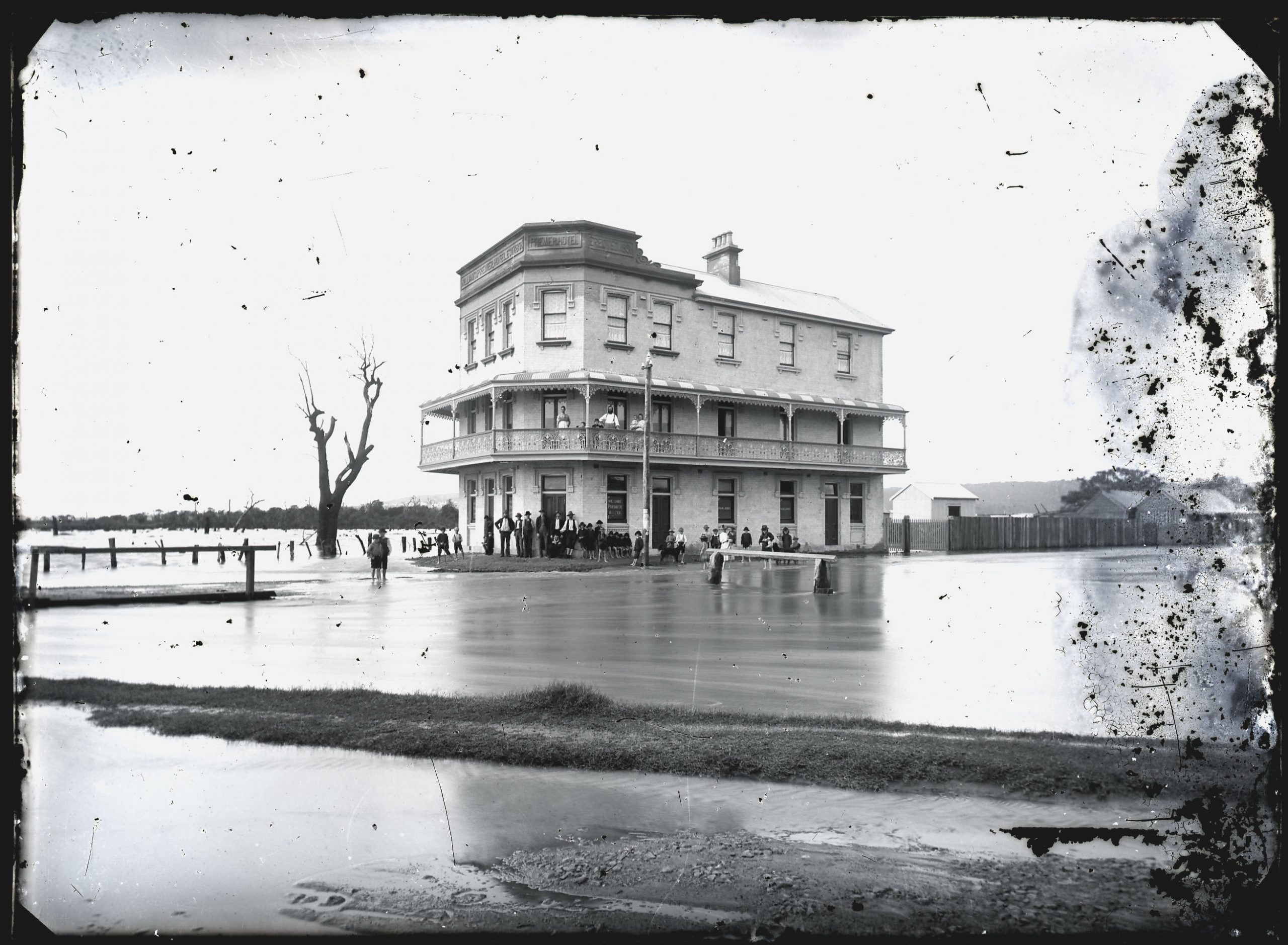
William Herbert was a pioneer of the cinema scene in Newcastle. Born in the United States, he moved to Newcastle in 1907 and began showing the new ‘moving pictures’ at various locations in Newcastle. In October 1910 Herbert announced plans to screen films in the open air at the Hamilton Rugby League ground on the north side of Belford St. The first night was a disaster. “Owing to the boisterous nature of the weather the moving pictures could not be held as the screen was blown down in the afternoon.”
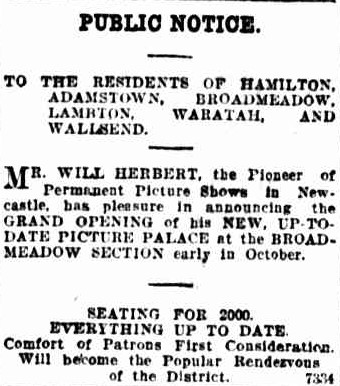
Despite the initial setback, Herbert persevered and regularly screened movies at the ground until 1912 when he opened a permanent theatre at the Nineways Broadmeadow. Seating 2000 people, the grandiosely named “No. 1 Picture Palace” was a basic structure with asphalt floor and canvas roof.
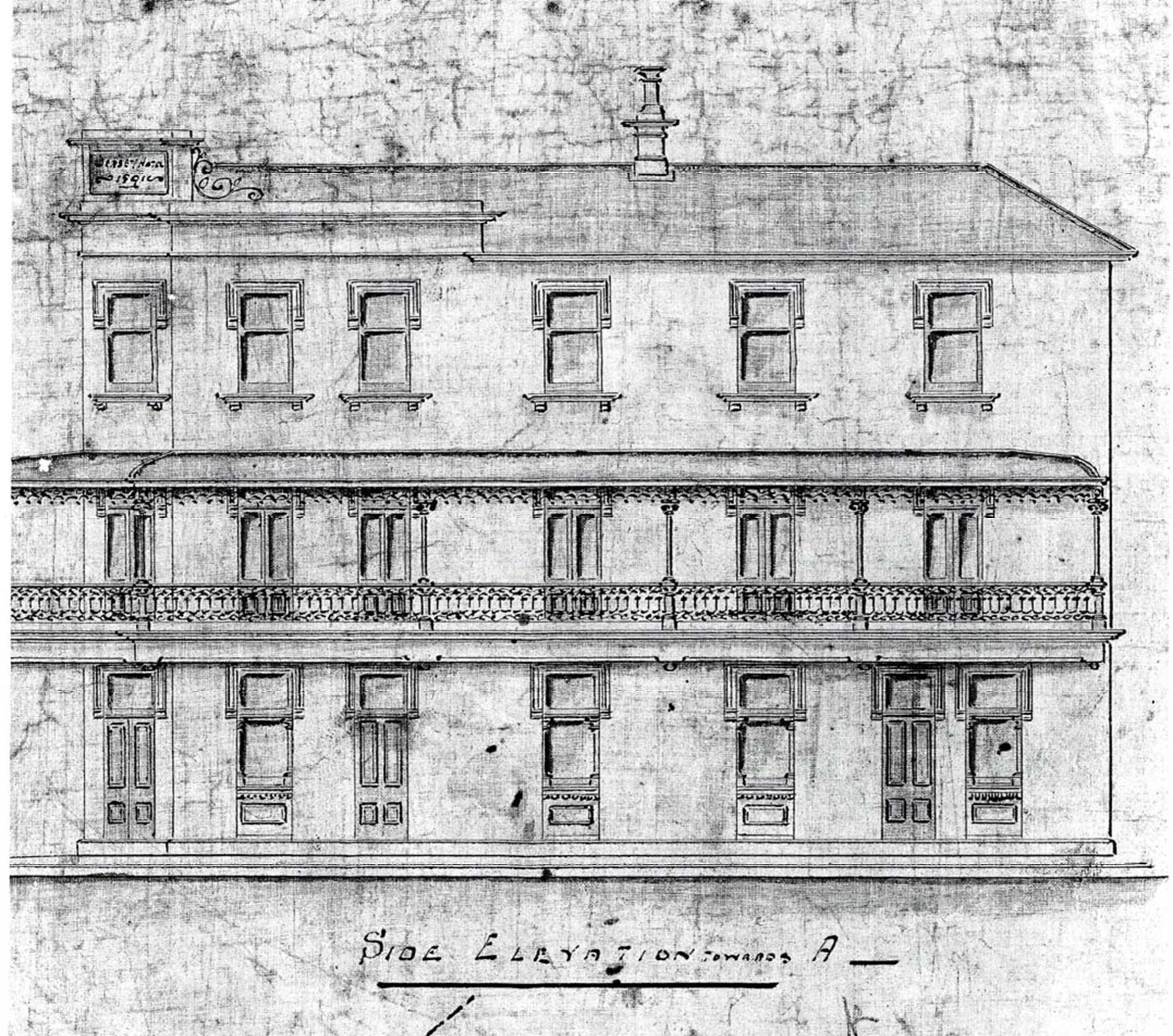
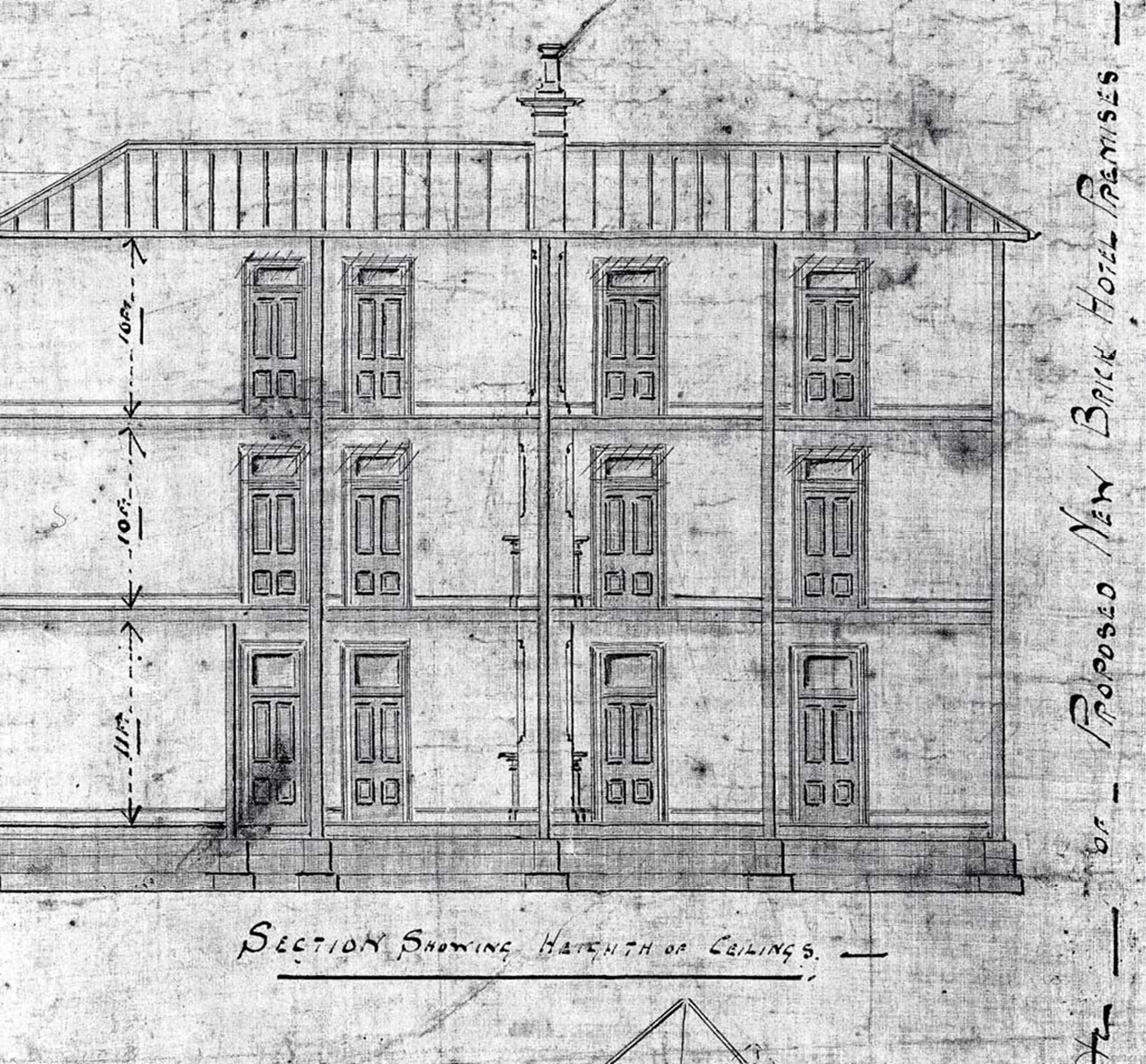
During 1923 and 1924, Herbert ingeniously managed the complete reconstruction of the building “without temporarily shutting down the theatre or seriously inconveniencing his patrons.” Corrugated iron walls were removed gradually and replaced with brick, steel girders installed, and the canvas roof replaced over a three-week period. “There were times when parts of the theatre had two coverings, but at every screening the audience was protected from the weather.”
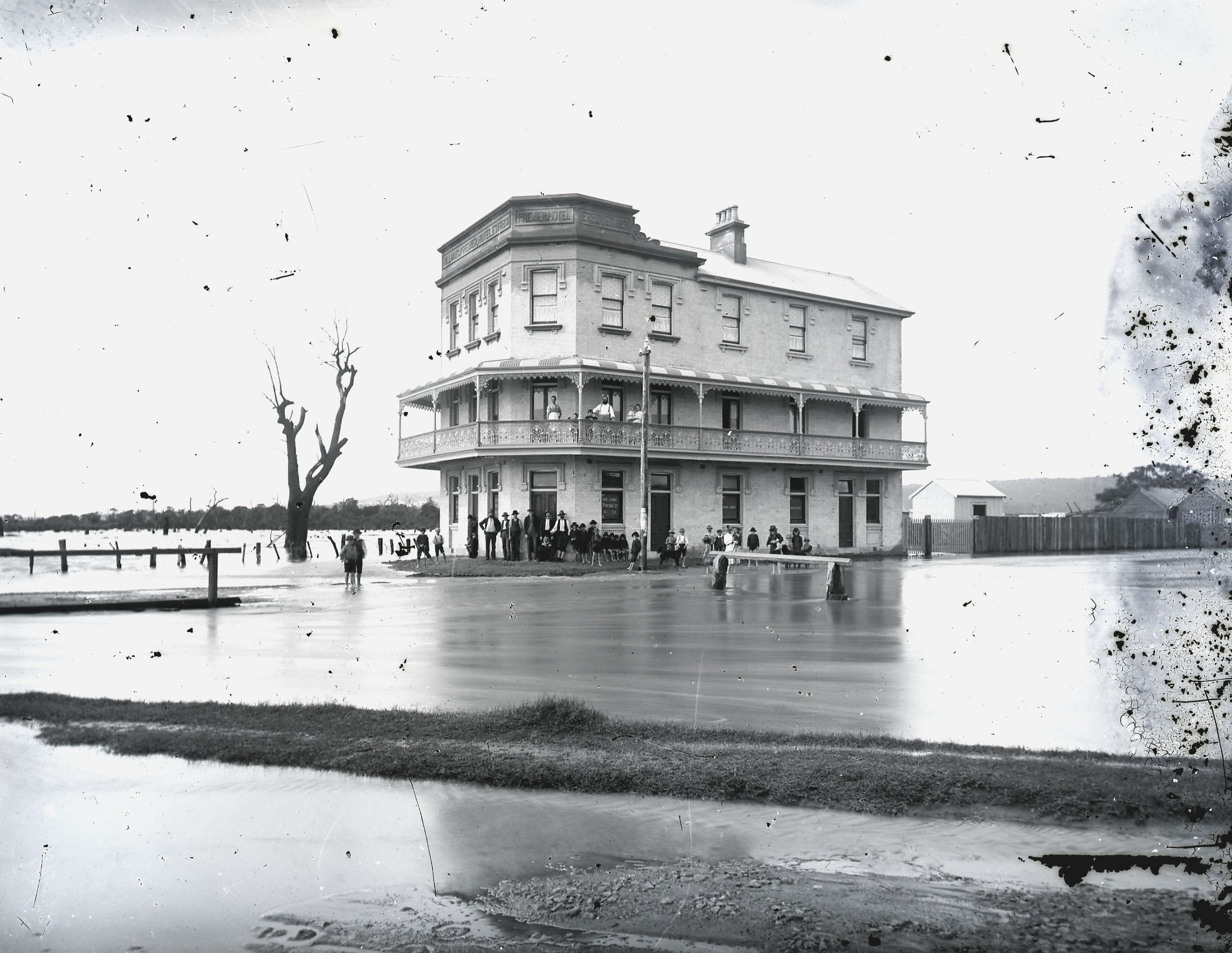
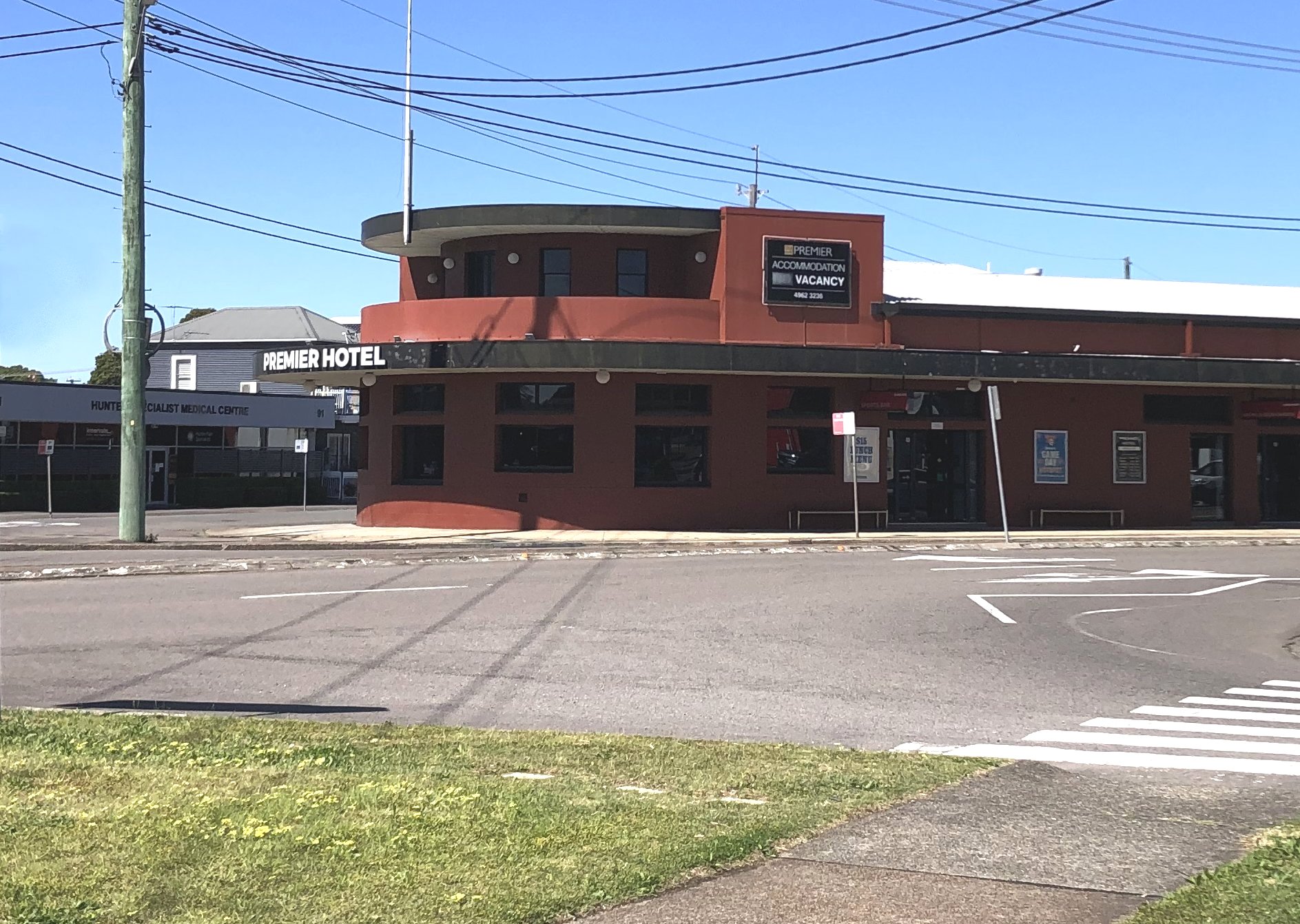
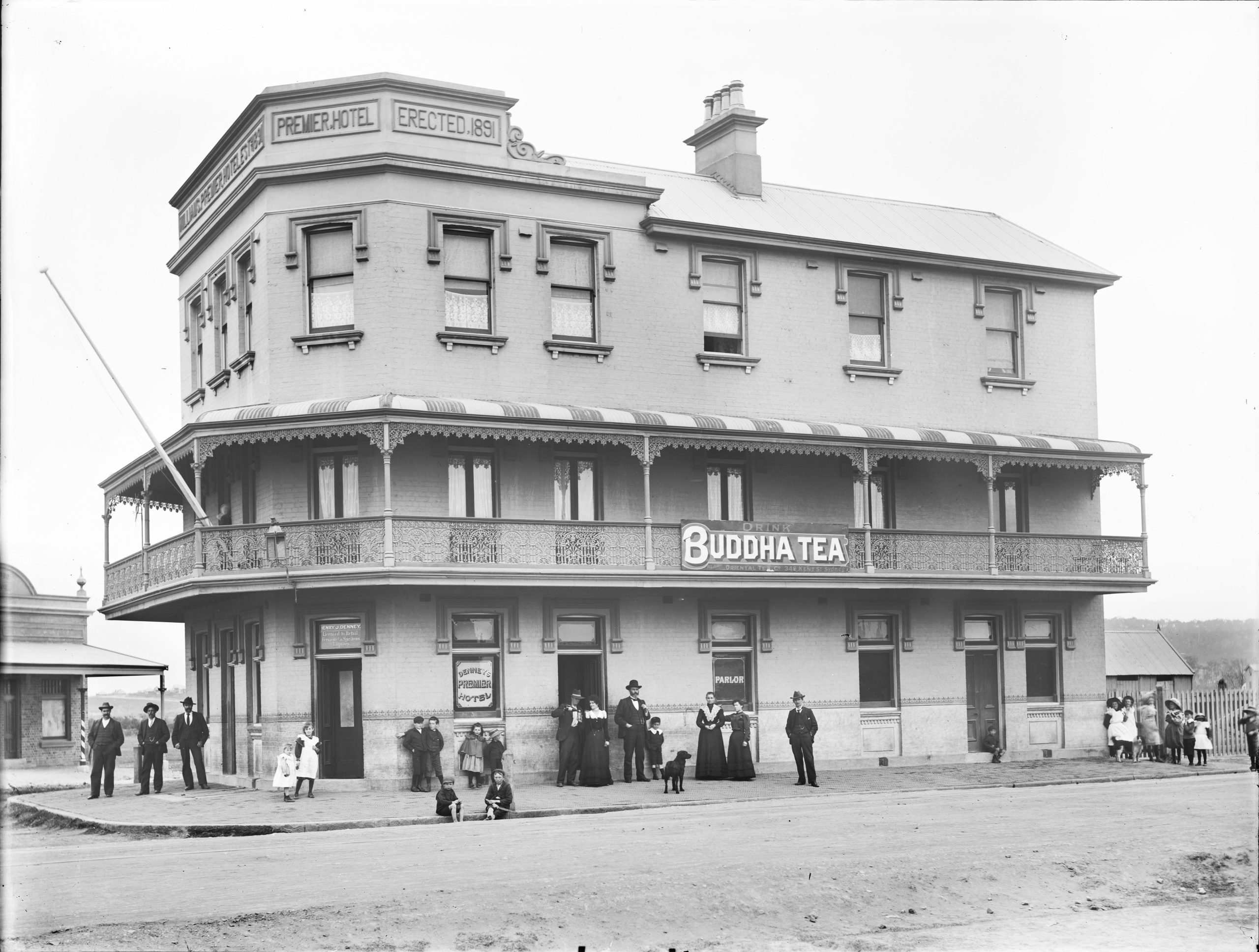
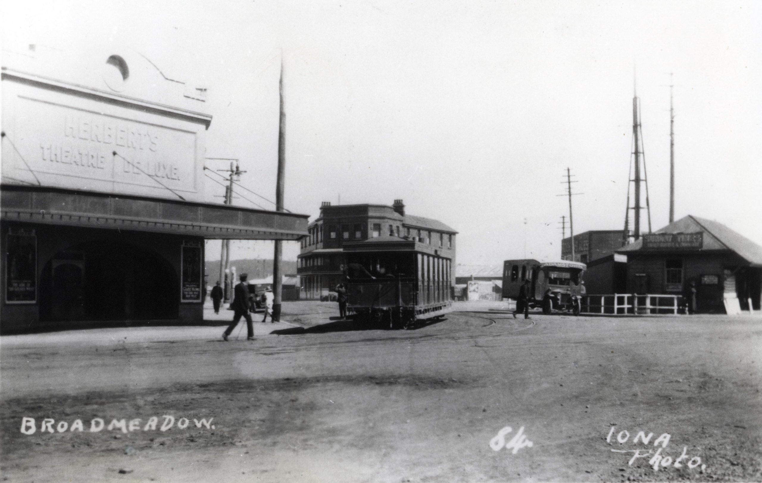
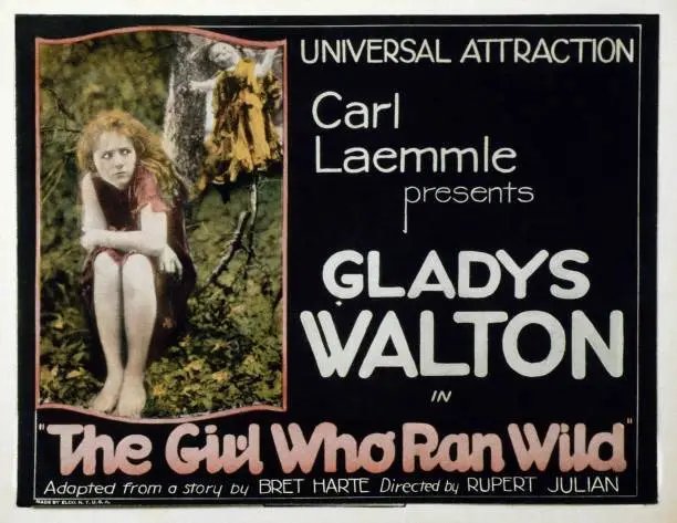
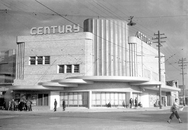
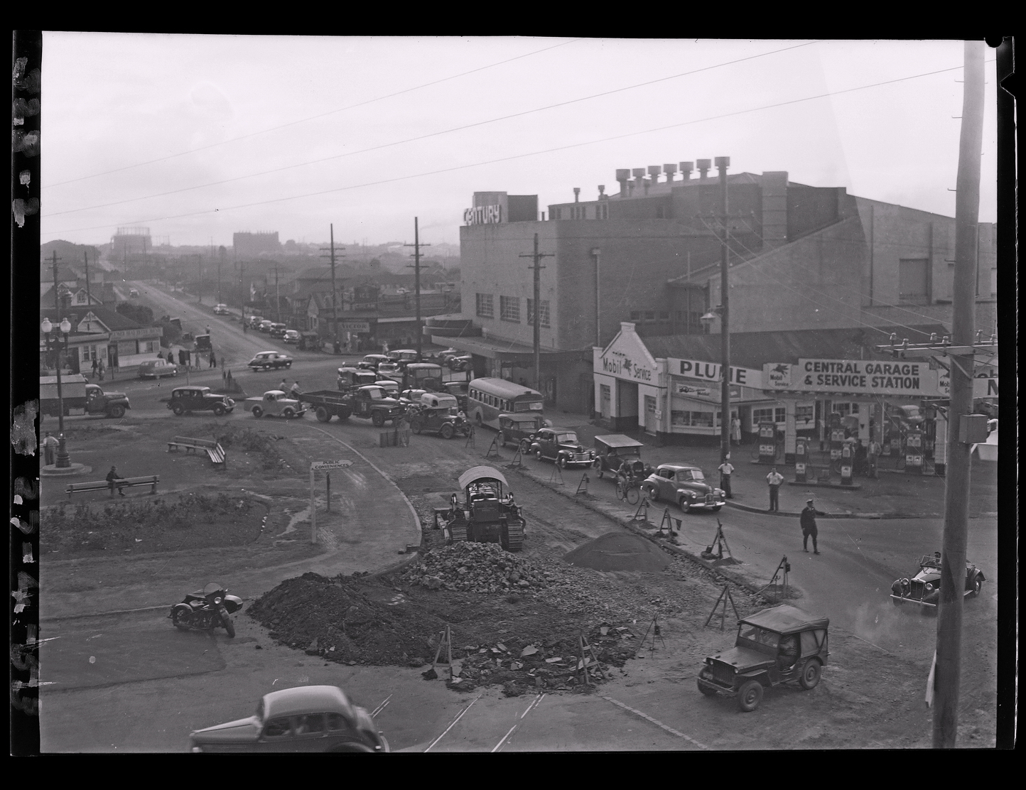
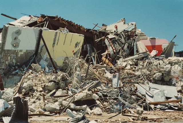
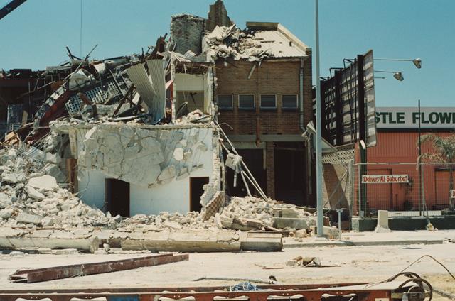
A photograph of the new “Herbert’s Theatre De Luxe” can be dated by close inspection of the poster on the right-hand side. It advertises Gladys Walton in the silent film “The Girl Who Ran Wild” that screened in September 1923. Herbert sold the theatre in 1933 and in 1941 the new owners announced plans for its demolition and erection of a new building. At a cost of £40,000 and a seating capacity of 1600, the new “Century Theatre” opened in April 1942 and had its final screening in September 1973. The building lay derelict for a while and was then variously used as a truck repair workshop, gaming arcade, and finally as a church. Badly damaged in the 1989 earthquake the Century Theatre was demolished soon afterwards.
According to a 1918 biographical article, Will Herbert was born in the town of Manchester, New Hampshire in the USA. Confusingly, an obituary in 1947 states that he “was born in New Hampshire, England, and was taken to America at the age of three” while another obituary states that he “was born in Lancashire”.
The kind of person he was is perhaps best illustrated in that he was an actual example of the cliche of running away from home to join the circus …
Mr. Herbert seems to have had a penchant for travelling, for at 16 – without his parents’ consent – he attached himself to Forepaw’s Circus, which at the time was second only in size and importance to the great Barnum and Bailey’s Circus.
Newcastle Morning Herald and Miners’ Advocate, 5 April 1918.
After touring with the circus for a couple of seasons, Herbert started a bakery business in Boston, bought into a French cafe in New York, went to San Francisco and became chief steward on a steam ship trading with the eastern Pacific. He then served as a commissariat officer on the troopship Naomi in the war between the United States and Spain, and then subsequently on a trans-Atlantic liner the General Grant, sent to the Philippines to quell an uprising.
It was while in the Philippines that Mr. Herbert conceived the idea of taking up motion pictures.
Newcastle Morning Herald and Miners’ Advocate, 5 April 1918
In 1905, Will Herbert was part of a syndicate that secured the rights to film and screen the Lightweight Championship boxing match between Jimmy Britt and Oscar “Battling’ Nelson, held at San Francisco on 9 September 1905.
Britt-Nelson boxing match in San Francisco, 9 September 1905. Library of Congress.
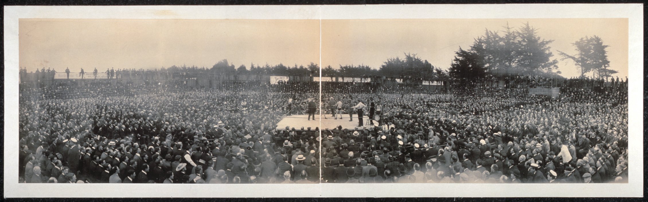
Soon afterwards, Herbert headed to Australia to exhibit the film of the fight.
Mr. Herbert, of the syndicate which secured the moving pictures of the Britt-Nelson fight in America for the world’s light-weight championship, arrived from America by the Sierra for the purpose of exhibiting the pictures throughout Australasia. He will open the Queen’s-hall, Pitt-street, on Monday next for a season, and a holiday matinee will also be given. Popular prices will be charged. Over 18,000 people witnessed this contest, which was very exciting; and the film representing it is over a mile in length.
Over the next two years Herbert toured all parts of Australia and New Zealand, showing the film in rented halls and theatres. He made at least two visits to Newcastle, in November 1905 and again in February 1906.
Mr. Herbert said that on his first visit to Newcastle he had noticed the possibilities for the establishment of permanent pictures.
Newcastle Morning Herald and Miners’ Advocate, 5 April 1918
Herbert appears to have settled permanently in Newcastle sometime in late 1907 or early 1908. By February 1908 he is mentioned as the manager of “Kings American Picturescope”, screening films at the Victoria Theatre in Perkins Street. He then rented the “Central Hall” in May 1908 for a period of 18 weeks, and also screened films at the Newcastle Sports Ground.
Hamilton Rugby League Ground
Will Herbert first screened moving pictures in the Broadmeadow area in the open air at the Hamilton Rugby League Football Ground. The first scheduled show on 22 October 1910 was cancelled due to inclement weather, however within a few weeks the paper reported …
The fine picture entertainment given by Mr. Will Herbert at the Rugby League Ground, Hamilton, is apparently growing rapidly in popularity, judging from the increasingly large audiences. Last night the new programme was witnessed by a very large attendance.
Excerpt of an 1884 map of Newcastle, showing the location of the Hamilton Rugby League Ground between Tudor and Belford Streets. University of Newcastle, Living Histories.A Google Earth image showing the approximate location of the Hamilton Rugby League Football Ground. The location of Herbert’s Theatre De Luxe is outlined in red.
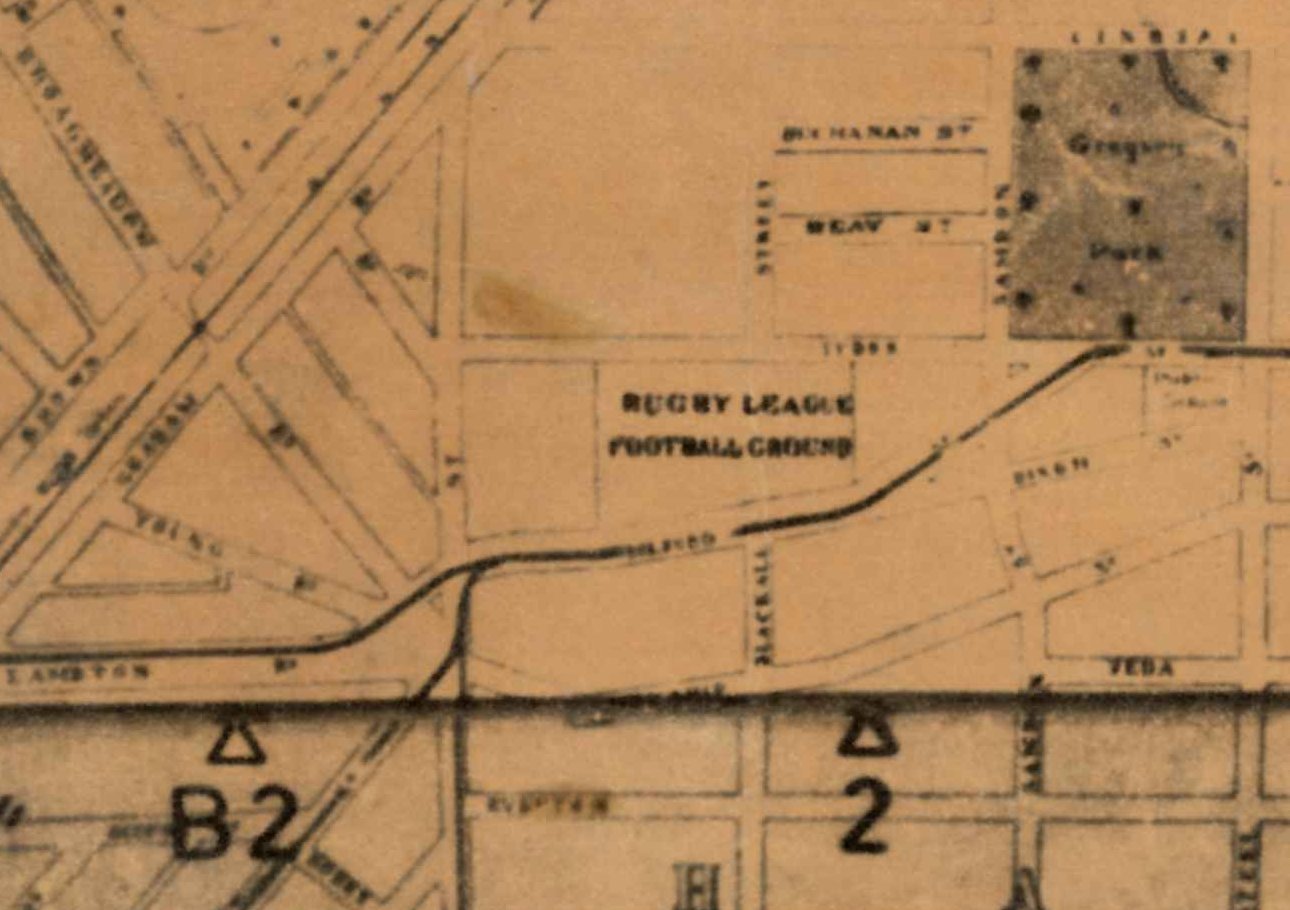
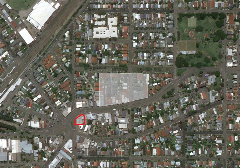
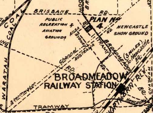
Will Herbert continued to regularly screen pictures at the ground until the final screening on Saturday 4 May 1912. The land occupied by the Rugby League Ground was later subdivided into 41 lots by the A. A. Company and sold in April 1918.
No. 1 Picture Palace
In August 1912, Will Herbert announced in a public advertisement his intention to open an “up-to-date Picture Palace” in Broadmeadow, capable of seating 2000 persons.
Herbert’s “No. 1 Picture Palace” at Broadmeadow opened on Saturday 2 November 1912, screening “Sweet Nell of Old Drury” starring Miss Nellie Stewart. A report on the opening noted that …
The attendance numbered just on 2000, and many were unable to gain admission. Extra seats were brought in, but these were not sufficient to accommodate those anxious to get in. The structure is a very commodious one, and commands an excellent position at the junction of the tram lines. The building measures 187ft by 85ft, and is admirably adapted for picture entertainment. The exterior was brilliantly illuminated for the opening performance. Three large stars and a Maltese cross formed of different coloured electric lights gave the outside a most picturesque appearance. The vestibule is attractively laid out, and the whole of the floor space of the building will shortly be asphalted. Patent spring back chairs are to be used for the higher-priced seats. The chairs already in use are very comfortable, and in every other respect patrons are well catered for.
Newcastle Morning Herald and Miners’ Advocate, 4 November 1912
By May 1913 further improvements to the theatre had been completed.
Herbert’s Picture Palace at Broadmeadow has now been completely roofed in with waterproof canvas, which will render it cosy and warm for the winter months.
Newcastle Morning Herald and Miners’ Advocate, 6 May 1913
Herbert’s Theatre De Luxe
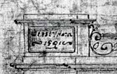
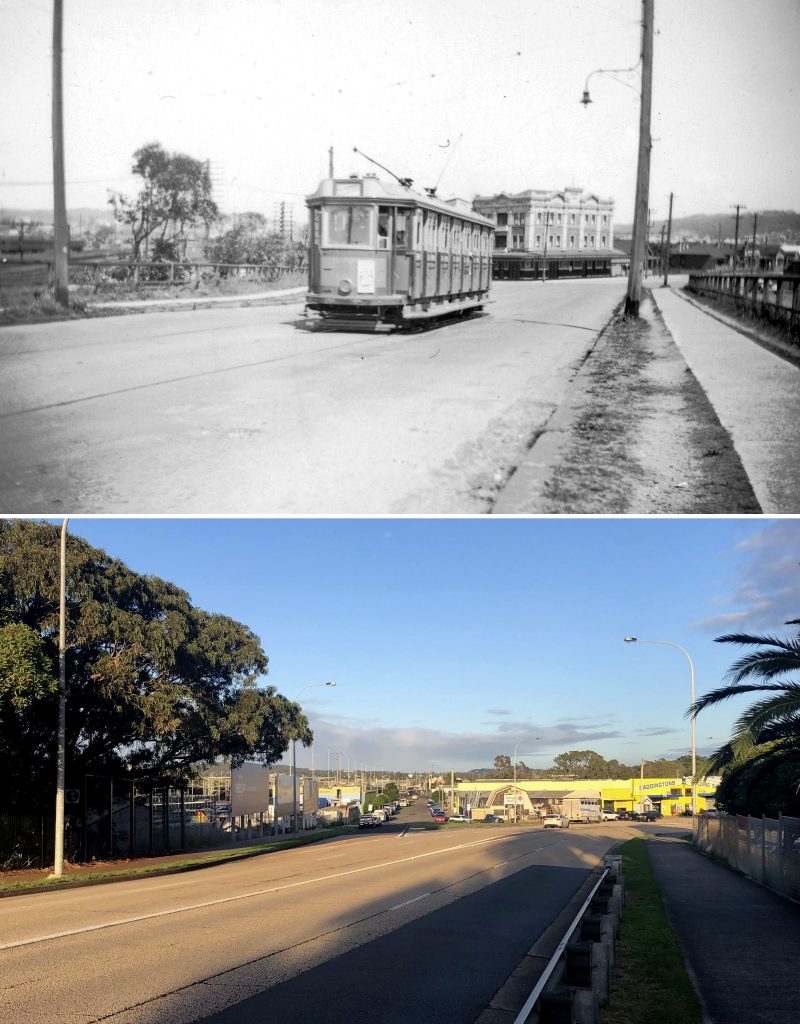
Originally the photograph of Herbert’s Theatre De Luxe was loaded into the Living Histories site with no attributed date. Noting from the article of June 1924 that the construction/renovation of the theatre was “spread over fourteen months”, and also noting from the photo that the tramline to Adamstown up Brunker Road is not yet electrified (which was completed in January 1925), indicates that the photo was taken sometime in 1923 or 1924.
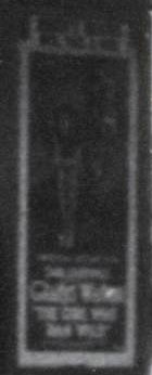
Getting a more exact date on the photo relies on identifying the movie being exhibited at the time of the photo, by carefully examining the poster on the right hand side of the entrance.
Taking a snip of the photo and enhancing the contrast, you can just make out the name “Gladys Walton” and the name of the film as “The Girl Who Ran Wild”. Additionally, a faint outline of a seated girl can be made out that matches the profile of the movie poster below.
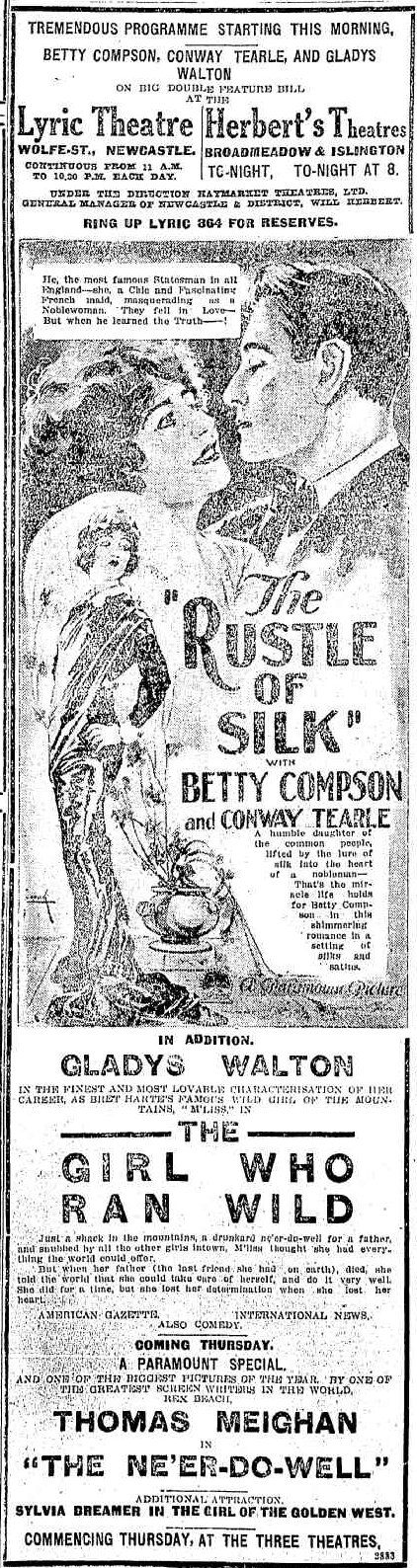
Searching newspaper advertisements in 1923 and 1924 reveals that the film was screening at Herbert’s Broadmeadow Theatre in the week beginning Monday 17 September 1923.
Advertisement for screening of “The Girl Who Ran Wild” at Herbert’s Theatre, Broadmeadow. Newcastle Morning Herald and Miners’ Advocate, 17 September 1923.
According to Cork and Tod’s book “Front Stalls or Back?”, Herbert divested control of his theatres to Newcastle Theatres Pty Ltd in 1933. Herbert retired in 1935 and visited the United States. A year later in January 1936 the directors of the Newcastle Theatres induced Herbert to take on the supervision of their theatres, including the De Luxe at Broadmeadow, Roxy at Hamilton, and Regent at Islington.
William Herbert retired again in 1941, and died on 11 November 1947 in Hamilton, at the age of 80.
Century Theatre
A start will be made on Monday on the new modern theatre at Broadmeadow. With equipment and furnishings the expenditure will exceed £30,000. The contract is the biggest announced in northern New South Wales this year. The building will occupy a splendid central site, with frontages to Chatham road and the Pacific Highway. To enable operations to proceed, it will be necessary to demolish the present theatre and other buildings erected by Mr. W. Herbert, founder of Herbert’s Theatres, 25 years ago.
Newcastle Morning Herald and Miners’ Advocate, 19 April 1941
The new Century Theatre opened on Friday 17 April 1942 with a screening of the Technicolor film “Aloma of the South Seas” starring Dorothy Lamour.
The Century Theatre, erected on the site of Herbert’s theatre in Broadmeadow, opened in April 1942. Photo from Cinema Treasures.Alterations to to roads at Nineways, Broadmeadow, with the Century Theatre in the background. 27 April 1953. Photo by Len Webber. Newcastle Libraries Online Collection 515 000075The Century Theatre, Broadmeadow, in the process of demolition after damage from the 1989 earthquake. Photo by Ron Morrison. Newcastle Libraries Online Collection 004 001134The severely damaged Century Theatre, Broadmeadow, being demolished. Photo by Ron Morrison. Newcastle Libraries Online Collection 004 001135
"Mr. Herbert, of the syndicate which secured the moving pictures of the Britt-Nelson fight in America for the world's light-weight championship, arrived from America by the Sierra for the purpose of exhibiting the pictures throughout Australasia."
"At the King's Hall on Saturday evening, Mr. Will Herbert introduced to Newcastle the celebrated motion pictures of the Britt-Nelson contest for the lightweight boxing championship of the world."
"The attendances at the Picturescope Palace, Newcomen-street, during the week, have been well up to the average, and Mr. Herbert, the manager, expresses himself well satisfied with the support that has so far been accorded his efforts to establish a permanent picture show in Newcastle."
"Mr. Will Herbert, formerly of the Picturescope Palace, Newcastle, announces that the first of a series of a continentals will be given under his direction at the Rugby League Ground, Hamilton, this evening."
"Owing to the boisterous nature of the weather on Saturday, the continental and moving pictures, promoted by Mr. Will Herbert, on the League Football Ground, at Hamilton, could not be held. The
screen was blown down in the afternoon, and at night there was no attendance of the public."
"The fine picture entertainment given by Mr. Will Herbert at the Rugby League Ground, Hamilton, is apparently growing rapidly in popularity, judging from the increasingly large audiences."
Herbert's Picture Palace at Broadmeadow has now been completely roofed in with waterproof canvas, which will render it cosy and warm for the winter months.
"The Girl Who Ran Wild, the Universal attraction starring Gladys Walton, which will be screened at the Lyric and Herbert's Theatres, Broadmeadow and Islington, on Monday next, is the latest and most appealing screen version of Bret Hart's story M'liss."
At the Lyric and Herbert's Pictures to-day there will be shown for the last time the Paramount special entitled "The Rustle of Silk," with Betty Compson in the lead. Gladys Walton is also seen in "The Girl who Ran Wild."
Long article detailing "the conversion of Herbert's Broadmeadow Theatre from an unprepossesssing building to one of the most modern picture exhibition houses in Australia."
"At the request of the Directors of Newcastle Theatres Ltd., Mr. William Herbert has resumed the supervision of the circuit embracing the De Luxe (Broadmeadow), Roxy (Hamilton), and Regent (Islington), Theatres."
"A start will be made on Monday on the new modern theatre at Broadmeadow. With equipment and furnishings the expenditure will exceed £30,000. To enable operations to proceed, it will be necessary to demolish the present theatre and other buildings erected by Mr. W. Herbert, founder of Herbert's Theatres, 25 years ago. "
"Another fine addition to the architectural grandeur
of the Newcastle district is the new Century Theatre at
Broadmeadow. Erected at a cost of over £40,000, and
with a seating accommodation of over 1600, the theatre
will-be opened officially on Friday night, at 7.45 o'clock"
In March 1891, Thomas Williams purchased land near Broadmeadow station, and submitted an application for a a conditional publican’s licence “for premises proposed to be erected at the intersection of the Adamstown and Newcastle-Wallsend roads to be known by the sign of the Jersey Hotel.” Williams engaged James Henderson, the eminent architect of the ornate Victoria Theatre in Perkins Street Newcastle, to design a three storey, 15-room brick hotel.
With the building completed in early 1892 and after a change of mind on the name, Williams applied for the publican’s license he needed for his Premier Hotel to commence trading. On Thursday 17 March 1892 the Licensing Bench approved his application, but instead of downing drinks in celebration, Williams found his hotel in the drink due to inundation. That very night the heavens opened and Newcastle was drenched with torrential rain, with flooding reported at Wallsend, Waratah, Lambton, and New Lambton. At Broadmeadow “the flat between Adamstown and New Lambton and down to Lambton-road was one sheet of water on Friday morning.” Ralph Snowball photographed the newly licensed hotel, an island of refuge in an expanse of water.
The deluge had tragic consequences when “an elderly man named Edward Atkinson fell into a waterhole while looking for cows in a paddock near Adamstown and was drowned.” Once again, citizens called on the government to get on with its long-promised drainage scheme for the area. The main stormwater drain through the Broadmeadow flats was completed in 1895, but the area around the Premier Hotel continued to be impacted by flooding until the completion of the Adamstown branch of the drain in 1899. In 1939 the hotel was rebuilt as an attractive two storey structure in the art deco style. Having survived a natural disaster in 1892, the hotel suffered damage in the 1989 earthquake and was repaired as a smaller, simpler building. Plans for a $34 million redevelopment of the site are now before Newcastle Council, for a nine-storey apartment building with ground floor pub.
Details from Land title Vol-Fol 1021-71, showing purchase of portion 2101 of the Newcastle Pasturage Reserve by Thomas Williams on 11 March 1891.
Pages 227-229 of “Early Architects of the Hunter Region” by Les Reedman shows three drawings by James Henderson of “New brick hotel, Newcastle Pasturage Reserve, near Broadmeadow Station, 1891”. The inscription on the top of the facade shows the originally proposed name of “Jersey Hotel”.
Premier Hotel, Broadmeadow, 18 March 1892 – looking westwards along Denison St. Photo by Ralph Snowball. University of Newcastle, Living Histories.Denison St Hamilton, August 2023. (The present day Premier Hotel is hidden behind the building with the blue awnings at the end of the street.)Premier Hotel, Broadmeadow, 13 September 1902. Photo by Ralph Snowball. Newcastle Libraries Online Collection 001 001055Nineways, Broadmeadow, with Premier Hotel in the background, September 1923. University of Newcastle, Living Histories.Premier Hotel, Broadmeadow, 1959. Newcastle Libraries Online Collection 460 000055The Nineways, Broadmeadow, NSW, Australia [c.1960’s]. University of Newcastle, Living Histories.
2023 Development Application
In a curious coincidence, just a week after I had completed writing this article for “The Local”, news emerged that the owners of the Premier Hotel have submitted a Development Application (DA2023/00886) to Newcastle Council for a $34 million development to demolish the existing structure and erect an nine-story building with hotel on the lower floors, and 48 apartment units on the upper floors.
Proposed re-development of the Premier Hotel at the intersection of Brunker Road and Chatham Street. Image from the architectural plans for DA2023/00886.
Update 20 Feb 2024: The Hunter Central Coast Regional Planning Panel has rejected the proposed development, stating that “The proposed development does not respond to its current context and is out of scale with surrounding development.”
"I, THOMAS WILLIAMS, of Carrington,
Landholder, do hereby give notice that
I desire to obtain, and will, at the next
Quarterly Licensing Court, to be holden at
Newcastle on the ninth day of April next,
apply for a Certificate, authorising the issue
of a Conditional Publican's License, for pre
mises proposed to be erected at the Junction
of the Adamstown-road with the Newcastle-
Wallsend-road, to be known by the sign of
"Jersey Hotel," and to contain fifteen
rooms, exclusive of those required for the
use of the family."
Licensing court … "Thos. Williams applied for a conditional publican's license for premises
proposed to be erected at the intersection of the Adamstown and Newcastle-Wallsend roads to be known by the sign of the Jersey Hotel." Despite objections from the police "the Bench said the plans showed
that the house would be a good one; and, as there was nothing against the character of Mr. Williams, the application was granted."
James Henderson, architect, tenders invited for “the Erection and Completion of extensive BRICK HOTEL PREMISES at Adamstown, near Broadmeadow Railway Station, for Mr. Williams.” Tenders close 20 June.
"The Premier Hotel, the property of Mr. T. Williams, situated at the intersection of Adamstown. Lambton, and Waratah roads, is near completion.” [This is the first mention of “Premier Hotel” in the newspapers.]
At "he Licensing Bench yesterday … an application for a license for new premises situated at the junction of the Adamstown and Wallsend roads was also granted."
"Waratah. The heavy rain which fell during Thursday night again caused a considerable overflow in the streets, and particularly in the vicinity of the station."
"New Lambton. THE HEAVY RAIN. The heavy rain, which fell during Thursday night, flooded the properties on the Lambton Road, adjoining the tramline. The large drains overflowed, and across both the road and the tramline was one sheet of water. Some of the residents had to leave their houses to take care of themselves, and seek shelter in the tramwaiting shed at the Raspberry Gully line crossing."
"Plattsburg. STORM WATERS. The exceptional downpour of rain early on Friday morning very soon flooded all the low-lying land, and the result was that the residents of Nelson-street, from John-street to the bridge, were again flooded. On this occasion the water rose some 9in higher than the former floods."
"Lambton. During Thursday night the heavy rains caused a good deal of damage to the streets of the municipality by washing gravel and other road material away. Pearson and Howe streets were flooded, but fortunately not high enough to enter the houses. A thorough system of drainage at the lower end of the district from New Lambton downwards, through Hamilton, is necessary to prevent these periodical floods, as the water then would have an opportunity of free access to the main channels to the sea. But at present it is a source of trouble and expense to the whole of these municipalities, and the sooner the proposed scheme of the Hamilton, New Lambton, and other councils is carried out the better for everybody concerned."
"It was reported yesterday morning that an elderly resident named Edward Atkinson was missing, and supposed to be drowned in Yates' paddock, between Adamstown and New Lambton … which proved to be correct, for after some time the body was brought to the surface, at about 10.30 am. The deceased was 72 years of age."
"In common with other parts of the district the rain has done a deal of damage to the roads in the municipality. The low lands have suffered considerably. The flat between Adamstown and New Lambton and down to Lambton-road was one sheet of water on Friday morning. Numerous dwellings were flooded. People who have lived on the Lambton-road for 17 years say that they never knew the water to be so high as it was on Friday. The proposed high drain will be a blessing to the district, and till it is completed the low lands between Adamstown, New Lambton, and Broadmeadow will continue to be under water in wet weather."
"One of the finest pieces of work done in this district is the much-spoken-of Commonage
drain. The other day we visited the work and were greatly surprised at the proportions of the huge drain. In fact it is— or will be in rainy seasons — a regular canal. It begins half way between New Lambton and Hamilton, and runs in a fairly straight line towards a creek flowing into the Hunter. The drain will easily carry off the storm waters from the large area of country comprising the Commonage."
"BROADMEADOW. Last night at 9 o'clock the flood waters were over Brunker-road, and people from Adamstown who wished to got to the tram were forced to wade through a foot deep of water on the road. A large number of dwellings in the locality, including the Premier Hotel, were surrounded by water."
"The construction of the Adamstown branch of the Commonage drainage work has been delayed while the culvert under the Government railway was in course of construction. With the exception of a small portion near the railway culvert, the drain is completed to near the Adamstown-New Lambton road."
"The Adamstown branch of the Commonage drain has stopped within a few chains of the Adamstown-New Lambton road near the railway station. The cause of the drain stopping at that point is in consequence of it being found necessary to carry it through private property, and as the authorities have not come to terms with the Waratah Company and other property holders work is suspended and the municipality suffers."
Report on how the flooding in the Broadmead area was not as bad as former times “which is directly due to the Adamstown branch of the Commonage drainage works being opened cross the Lambton-road, and the Adamstown water thus being given straight course to the main drain.”
"Mr. M. S. Love, Acting S.M., yesterday granted Thomas Williams permission to transfer his license of the Premier Hotel, Broadmeadow, to Henry Joseph Denney."
"The Premier Hotel at Broadmeadow,
is to be demolished. On the site will be
erected a modern hotel, in two storeys,
the cost of which will be £20,000.
The architect is Mr. C. Ruwald, of
Sydney."
"To-morrow an official opening ceremony will be held at noon at the Premier Hotel at Broadmeadow to mark the completion of a most attractive and modernly designed addition to the hotels of the district.
The new building has a frontage to two main roads and a striking architectural treatment coupled with most up-to-date interior facilities and furnishings provide an outstanding example of a modern trend in hotel design"
Broadmeadow has been in the news recently, with the Department of Planning and Environment releasing their “Hunter Regional Plan 2041”. The document flags Broadmeadow as a “regionally significant growth area” and promises to make it “a destination of choice for entertainment, housing, recreation and discovery.”
This is not the first time the area has been subject to great change, as the photos this month demonstrate. A 2016 aerial photo shows the area bounded by Griffith Rd, Turton Rd, Broadmeadow Rd and the stormwater drain, filled with sporting grounds, trotting track, entertainment facilities, commercial and residential buildings. In contrast, seven decades years earlier it was an empty paddock, the site of District Park Aerodrome.
Originally a swampy lowland, the completion of a large concrete stormwater channel in 1899 allowed the surrounding area to be developed for recreation. The government reserved a portion for aviation purposes in 1923 and in 1928 the Newcastle Aero Club formed and began using the aerodrome. However, the combination of increasing aircraft movements and residential development posed a very real danger to the public.
On 20 January 1953, 70 years ago this month, newly qualified solo pilot Alan Kerle was practicing landings in an aero club Tiger Moth. As he landed, the plane bounced, was caught by a cross wind and carried across Turton-road where it brushed a rooftop, plunged into the back yard of Cedric Jenkins and burst into flames. Just minutes beforehand four children had been playing in the yard. Despite the damage the pilot walked away uninjured. Between 1931 and 1954 the newspapers reported 13 plane crashes at or near the aerodrome. The suitability of the site was increasingly questioned. In 1961 the Department of Civil Aviation gave notice to the Aero Club to vacate the Broadmeadow airfield, and they soon relocated to Rutherford. The government’s grand plans for aviation in District Park had proved unworkable. Let’s hope their grand plans for Broadmeadow in 2041 prove to be of long-lasting value.
District Park aerodrome, 1954. The site of the 20 January 1953 Tiger Moth crash is circled in red. NSW Historical ImageryThe same area of Broadmeadow in 2016. NSW Historical ImageryExcerpt from page 105 of the “Hunter Regional Plan 2041”, stating some of the state government’s plans for “Hunter Park” in Broadmeadow.
The article above was first published in the January 2023 edition of The Local.
Broadmeadow Aerodrome
Further information about the history of the Broadmeadow Aerodrome can be found in my August 2019 article on the crash of a C47 aircraft in 1944.
Grouped about the Aero Club, ‘planes at District Park this afternoon, parties of school children have the theory of aviation explained to them. The inspection was part of the club’s programme this week to mark its tenth anniversary. The Newcastle Sun 12 October 1938.
Wreckage of the Tiger Moth that crashed near Broadmeadow Aerodrome on 20 January 1956. The Daily Telegraph.
The wreckage of a Tiger Moth aircraft which crashed into the backyard of a home at Newcastle on 20 Juanuary 1953. The Sydney Morning Herald.
The scene in the backyard of a house in Turton road, New Lambton, after an Aero Club plane had crashed last evening. The fowlyard of the home in the foreground, with the plane lying across the back garden. Newcastle Morning Herald and Miners’ Advocate.
Other Broadmeadow aeorodrome crashes
The following table summarises airplane accidents that occurred at or near the Broadmeadow (District Park) aerodrome that were reported in the newspapers. This is not a comprehensive list of all incidents that occurred. For example, the report on 12 August 1944 notes that the stormwater drain has caused “7 crashes in 2 years”, however only two of those crashed seem to have been reported in the papers.
The plane fell into a spin at an altitude of 2000 feet and crashed into a paddock adjoining the aerodrome. Pilot (E Buck) and passenger (G Lynch) uninjured.
The propeller caught in street lighting wires while the machine was making a forced landing. The pilot, Captain H. S. Preston, was uninjured, but the machine was severely damaged.
Two accidents in 2 days! Damage to the undercarriage in 26/9/1935, and then the following day “the ‘plane struck some rough ground at the south-eastern end and pitched forward on to its nose. The fuselage, undercarriage, and propeller were damaged, and Mr. Hall received lacerations to an ankle.”
Forced down with engine trouble. Crashed in Lindsay Street Hamilton after hitting an electric light pole. Pilot Frank Cook pulled unconscious from the wreckage, and treated at hospital for abrasions and contusions to the face, lacerations, slight concussion, and shock.
Engine trouble, with white smoke issuing from the Beaufort bomber. The plane made a right hand turn, to land at Broadmeadow aerodrome, hit some trees in District Park and immediately burst into flames. The plane then hit the side of a deep stormwater drain, skidded on to the tramline, and came to rest in Lambton-road, Broadmeadow. Flight Sergeant William Milton Trengove, 34, navigator, of Spalding, South Australia, died later in Newcastle Hospital.
A U.S. Army transport plane, making a forced landing in a storm at Newcastle, crashed into a stormwater channel at Broadmeadow aerodrome. In the past 10 months two other planes have crashed into the stormwater drain while trying to land at Broadmeadow. Two U.S. airmen were injured in the crash. The pilot suffered a broken nose and abrasions, and the radio operator head injuries.
A Wackett trainer belonging to the Newcastle Aero Club, took off from the Broadmeadow aerodrome.The engine cut out at 150 to 200 feet, and the pilot brought it down in a paddock, narrowly missing two people walking along a track. The pilot (Dick Gilford, 22, of Carrington Parade, New Lambton), and passenger (Mr. A. Gilford) were uninjured.
After engine failure, the pilot Jack Stone crash landed the Wackett trainer on rough, undulating ground off Turton-road near District Park aerodrome. The plane was damaged, but the pilot was uninjured.
Two men scrambled unhurt from the cockpit of a Ryan monoplane which crashed on a narrow vacant allotment near Broadmeadow aerodrome. They are Louis Plumstead of Beresfield, an instructor employed at the Newcastle Aero Club, and his pupil, Victor Boyce, of Maitland.
A Tiger Moth plane partly unroofed a house, crashed into a fence, and burst into flames. The pilot, Alan Roger Kerle, 24, of Boyce Street, Taree. climbed from the wreckage unhurt.
The undercarriage of the aircraft collapsed when the plane was landing. The plane slewed wildly across the runway and its port wings ploughed into the ground.
Mr. E. Buck's "Sky Hawk," a De Havilland Moth 'plane, at District Park, yesterday with one passenger
aboard (Mr. G. Lynch, of Waratah) fell into a spin at an altitude of 2000 feet and crashed into a paddock adjoining the aerodrome."
"Newcastle Aero Club's new Tiger Moth biplane, the Halcyon, crashed at District Park late yesterday afternoon. The pilot, Captain H. S. Preston, was uninjured, but the machine was severely damaged."
"THE Westland-Widgeon 'plane, which was involved in a sensational crash at the District Park Aerodrome last evening, wrecking the undercarriage, figured in another accident this afternoon. AFTER repairs had been effected to the landing gear, the owner, Mr. Hall, made a preliminary flight prior to leaving for Sydney.
When returning to the 'drome, however, the 'plane struck some rough ground at the south-eastern
end and pitched forward on to its nose. The fuselage, undercarriage, and propeller were damaged, and Mr.
Hall received lacerations to an ankle."
"Five passengers in the airliner 'City of Grafton' had remarkable escapes this morning when a wheel collapsed after the big 'plane had landed at District Park aerodrome, throwing the 'plane on to its side."
"The discovery of four slashes in the fabric underneath the wing of an aeroplane shortly before it was due
to take off caused a stir at District Park Aerodrome this morning. Mr. Henry said that the incident illustrated the need for public hangars at all important aerodromes."
"The small high wing monoplane Sky Baby crashed in one of Newcastle's most thickly populated suburban thoroughfares, Lindsay-street, Hamilton, shortly after 5 p.m. to-day. The right wing struck an electric light pole and was torn off. The machine finished partly on the footpath."
Calls to improve Broadmeadow aerodrome … "The present aerodrome is entirely inadequate for the future
needs of a city the size of Newcastle,' said Mr. Cavalier, "Further, it is in its present size a danger to certain types of aircraft."
"A U.S. Army transport plane, making a forced landing in a storm at Newcastle yesterday, crashed into a stormwater channel at Broadmeadow aerodrome. Two U.S. airmen were injured."
"A pilot, with his father as passenger, crashed in an emergency landing at East Lambton today. Neither was injured. The pilot is Dick Gilford, 22, of Carrington Parade, New Lambton, the passenger is Mr. A. Gilford, of the same address. The plane, a Wackett trainer belonging to the Newcastle Aero Club, had taken off from the Broadmeadow aerodrome. The engine cut out at 150 to 200 feet, and the pilot brought it down in a
paddock, narrowly missing two people walking along a track."
"The pilot of a Wackett trainer plane escaped injury when he crash landed on rough, undulating ground off Turton-road near District Park aerodrome yesterday afternoon."
"Two men scrambled unhurt from the cockpit of a Ryan monoplane which crashed on a narrow vacant allotment near Broadmeadow aerodrome this afternoon. The engine cut out soon after the plane took off
from the aerodrome."
"When a Tiger Moth plane crashed today it partly unroofed a house, crashed into a fence, and burst into flames. The pilot climbed from the wreckage unhurt. As flames reached the petrol tank a bus driver
put them out with an extinguisher from his bus. The pilot of the plane is Alan Roger Kerle, 24, of Boyce Street, Taree. He is a student pilot of Newcastle Aero Club. The crash occurred as he was landing the plane on Newcastle aerodrome." (The Daily Telegraph)
"When a Tiger Moth aircraft crashed into the backyard of a home in Turton Road, Waratah, a suburb of Newcastle, shortly before 5.30 p.m. to-day it missed a woman and four children by four feet. The sole occupant, Alan Roger Kerle, 24, of Boyce-Street, Taree, was not injured." (The Sydney Morning Herald.)
"A Tiger Moth plane owned by Newcastle Aero Club crashed in the backyard of Mr. C. Jenkins's property in Turton road, New Lambton, late yesterday afternoon. The plane was extensively damaged but the pilot, Alan Roger Kerle, 24, of Taree, who had made his first solo flight on Sunday, climbed uninjured from the cockpit. A wing hits the edge of a fernery in a house adjoining and caught fire. The plane dropped on to its nose, pivoted, and then landed on its wheels." (Newcastle Morning Herald and Miners' Advocate.)
"A De Havilland Hornet bi-plane, crashed on landing at Broadmeadow about 5 p.m. today. Crew of the plane, Mr. J. Neal, of Tamworth (pilot) and Capt. R. Hall, of East. West Airlines (navigator) were uninjured in the crash. The undercarriage of the air craft collapsed when the plane was landing. The plane slewed wildly across the runway and its port wings ploughed into the ground."
The naming of coal mines is often ambiguous and confusing, especially when a locality name is used for a mine in a completely different region. Such is the case with the short lived Hartley Vale Colliery in Newcastle in the 19th century.
Today when we hear “Hartley Vale” we think of the Hartley Vale on the western side of the Blue Mountains, near Lithgow. A form of coal called kerosene shale was found in this location in 1865, and by 1874 the NSW Kerosene Shale and Oil Company had a substantial mining operation there. But 150km away in Newcastle there was another “Hartley Vale” colliery, with no connection to the Blue Mountains.
In 1862 the brothers James and Alexander Brown were operating a colliery at Minmi, west of Newcastle. In late 1862 they issued a prospectus for a new company, called the Melbourne and Newcastle Minmi Colliery Company, and by February 1863 had sold their mine to the newly floated company. Around the time they were divesting themselves of the Minmi colliery, the Browns acquired the coal lease on a 310 acre block of land in the Broadmeadow area adjacent to Hamilton. This new venture they named “The Hartley Vale Colliery” (sometimes spelled “Hartly Vale”) and commenced to develop it, including plans to build a rail line from the pit to the Great Northern Railway
THE HARTLY VALE COLLIERY. This new colliery which has been in the course of development for several months, having bared a good seam of coal and began to open it out, is now also about beginning the formation of a railway to connect the works with the Great Northern Line, to come in somewhere about the spot where the Waratah and Lambton junction is formed. This line has been surveyed and cleared, and in the course of a few days it is anticipated that the formation will be commenced.”
The Maitland Mercury and Hunter River General Advertiser, 13 August 1863.
By June 1864 the Browns had reportedly spent £12,000 developing the mine which was nearing completion.
The works at the Hartley Vale Colliery have proceeded so far as to be ready for coming into market, with the exception of the completion of a small portion of the branch line intended to form a junction with the Lambton. In consequence of a dispute between the two companies, the progress of this line has been retarded.
The Maitland Mercury and Hunter River General Advertiser, 25 October 1864.
The completion of the rail line from the Hartley Vale mine was prevented because of a dispute with a competitor, the Lambton colliery. To remedy this impasse the Browns petitioned the government to to pass an Act of Parliament to give them the right to construct their railway. The Bill was brought before the Parliament in October 1866, but ongoing disputes and opposition from competing interests meant that the bill was not passed until December 1867.
Having finally obtained the legal right to build their railway, it was of no consequence, for by this stage, after spending £18,000 the mine had already proved to be unprofitable.
No sooner was the Minmi Company floated (1863) than the Browns took up land at Hartley Vale, sunk their shaft, erected their winding gear, and other appliances ; but found the seam run out so shallow as to be unprofitable to work, so that was dismantled and abandoned, with a loss of £18,000.
Report on the death of Alexander Brown, Australian Town and Country Journal, 7 July 1877.
About the same time that the Hartley Vale Colliery railway Bill was passed in December 1867, the Browns acquired a new coal mining lease in the adjacent area of New Lambton, and within a few months were pushing ahead with the development of the New Lambton Colliery, including a branch rail line that was to use materials from the failed Hartley Vale venture.
The greater portion of the [New Lambton] line will be constructed with the material used in the formation of the old line to the Hartley Vale colliery, which turned out such a lamentable failure, and through which the Messrs. Brown lost such an enormous sum of money.
The location of the failed Hartley Vale colliery can be identified by the Hartley Vale Colliery Railway Bill and accompanying map. The Bill describes the railway as passing through …
“… fifty-four and three hundred and ten acres leased to the said James Brown and Alexander Brown and known as the Hartley Vale Colliery.”
The 54 acre block was the area eventually sold to Thomas Adam in 1869 to form Adamstown. The 310 acre block stretches from Adamstown to Broadmeadow, with the approximate location of C and D pits as shown in the Google Earth overlay below.
Location of C and D pits of the Hartley Vale colliery.
A passing remark in a parliamentary discussion about Reserves, indicates that the the Browns had acquired a mining leases in Newcastle by July 1863. "The Government, however, had leased portions of it [Newcastle Pasturage Reserve] to the Australian Agricultural Company, James & Alexander Brown, and the Waratah Coal Company."
"The Hartly Vale Colliery.-This new colliery which has been in the course of development for several
months, having bared a good seam of coal and began to open it out, is now also about beginning the formation of a railway to connect the works with the Great Northern Line, to come in somewhere about the spot where the Waratah and Lambton junction is formed."
"The Co-operative, Wallsend, the Hartley Vale, and the Australian Agricultural and Coal Company, are contemplating running onto" the Great Northern Line.
"I may mention that a rumour gains ground here that some desire is evinced by the Messrs. Brown
to connect the projects of the Co-operative Company and the Hartley Vale Colliery. On the Company's property it is said that £10 000 have been expended, and £12,000 on the Vale." [There is no evidence that this rumoured joint venture proceeded.]
"A report was in circulation a short time ago, that Messrs. J. A. Brown had some intention of working the seam of coal which exists on a property of theirs, called Hartley Vale, adjoining the Co-operative Company's pits."
"The works at the Hartley Vale Colliery have proceeded so far as to be ready far coming into market, with the exception of the completion of a small portion of the branch line intended to form a junction with the Lambton. In consequence of a dispute between the two companies, the progress of this line has been retarded, which, however, is now in a fair way of being completed in a few weeks."
"Towns have sprung up and forests have been cleared with surprising rapidity. A dozen years ago no one know of the Glebe, of Wallsend, Minmi, Lambton, or Hartley Vale … But notwithstanding all the improvements in the town, and all the facilities for trade, one cannot help feeling that there is a sort of lassitude about the movements of people-a sort of 'hanging on' appearance … Lambton and Waratah
doing only about quarter-time, and Wallsend, which is, perhaps, best off, not doing more than half its capabilities. Minmi, Tomago, Hartley Vale, and the Lake Macquarie pits doing nothing."
Partial opening of the Hartley Vale Railway. The descripton of the piece of line just opened suggests that it was the branch line from the Hartley Vale line that went eastwards to the Dog and Rat pit, and in 1868 to the New Lambton colliery.
"The greater portion of the [New Lambton Colliery] line will be constructed with the material used in the formation of the old line to the Hartly Vale colliery, which turned out such a lamentable failure, and
through which the Messrs. Brown lost such an enormous sum of money."
"NEW LAMBTON. The old Hartley Vale pit, which has been standing open for several years without any protection, is now being covered over by the employees of the Messrs. Brown."
In a report on Alexander Brown's death … "No sooner was the Minmi Company floated than the Browns took up land at Hartley Vale, sunk their shaft, erected their winding gear, and other appliances ; but found the seam run out so shallow as to be unprofitable to work, so that was dismantled and abandoned, with a loss of £18,000."
The 19th century saw the birth of a new mode of grocery retailing – the Cooperative Society movement. Begun in the UK and brought to Australia by immigrants, the core idea was for consumers to own, control and benefit from their local store. Membership was open to all through the purchase of shares, controlled through democratically elected officers and regular meetings, and profits returned to members as dividends.
However, in the 1890s a prolonged economic depression put the society under financial strain. With many miners out of work, trade fell dramatically. The working capital of the society slowly eroded with over-optimistic dividend payments in the face of declining profits, and members withdrawing from the cooperative. By April 1897 the financial position was untenable, and the society closed. Only the largest cooperative societies, with many members and multiple stores, survived the downturn.
Gittins and Eastham Store, Broadmeadow, September 1897. Photo by Ralph Snowball, University of Newcastle, Living Histories,The store was located at 3 Brunker Rd Broadmeadow, where the Premier Hotel carpark is today.
The article above was first published in the March 2021 edition of The Local.
Additional Information
The Broadmeadow Co-operative Society
The Broadmeadow Co-operative Society got off to a good start. After six months of operation, at their second quarterly meeting pm 31 October 1887, the secretary Mr W Roe presented a report and balance-sheet …
… which showed the society to be in a flourishing and prosperous condition, both with regard to members and financially. The shareholders number 69; paid-up shares, 104; unpaid-up shares, 22. The weekly takings at the store average over £50 per week. There is also a large number of non-members who purchase their goods at the store. The balance-sheet also showed that a large sum had been spent during the quarter in procuring a horse and cart and other necessaries required in the business; but despite this expense the society was enabled to declare a dividend of ten per cent. The report and balance-sheet were unanimously adopted, and the shareholders were very jubilant over the progressiveness of the society.
Location of Broadmeadow Co-operative Society Store. 10 Lambton Rd (April 1887 to April 1889) and 3 Brunker Rd (May 1889 to April 1897).
At the district Co-operative Conference held at Burwood on Saturday 13 July 1889, Mr R Gray, manager of the Pioneer Society at Burwood delivered a speech on “The rise and progress of cooperation in this district.” In the speech Mr Gray described the essence of the Co-operative movement as being …
“… that the profits of an undertaking do not go into the pocket of an employer, be that employer an individual, or several individuals united in partnership; but that they should be shared by the largest possible number of those who engage in the undertaking, either as consumers or workers. In our distributive co-operative societies the net profits on sales, after paying working expenses, interest on capital etc, go to the consumer.”
Mr Gray gave detailed statistics on each of the district societies, including the Broadmeadow Co-operative Society, which …
“… started business on April 17th, 1887, with 17 members, and a share capital of £14, and a loan of £50, making in all £94. They have paid away in dividends to members on their purchases alone, since they commenced, £1037 6s. Their share capital at the end of this quarter is £685 11s 10d, and the number of members on their books is 173. These facts speak for themselves. Then there is the fact of their having purchased the premises which they now occupy, their fixed stock account amounting to £200.”
The premises purchased by the society was on the Newcastle Pasturage Reserve (Commonage). The location can therefore be identified from the Land Court Sittings in July 1890, when people of the Commonage were finally able to apply for legal title to the land they were residing on. From the sitting of the court on 28 July 1890 …
“Portion 2102; applicants, the Broadmeadow Cooperative Society, Limited. The district surveyor reported that the land was valued at £103 4s, and he submitted that the applicants should prove ownership of the improvements. James Raine stated that he was president of the Broadmeadow Co-operative Society, Limited, and he appeared in support of an application made by John A. Davidson, the then secretary of the society, for portion 2102. The society owned the improvements on the portion, which consisted of a shop and outbuildings. The land had been purchased from Charles Heath, who had been in occupation prior to 1888, and the purchase was completed on the 25th May of that year. Witness claimed that the society had a perfect right under the Act to make application for the portion, as they had been in continued occupation since purchasing. Heath had not, to witness’s knowledge, made application for the land. After a short discussion, the board stated that they would adjourn the further consideration of the appraisement until they were dealing with other portions in the same vicinity. In the meantime, they would recommend that the application be accepted.”
Subsequently on 4 September 1890, the Land Court formally accepted the application of …
“Broadmeadow Co-operative Society, Limited, lot 2102, £163 4s”
The Co-operative’s store is just visible on the right hand side of Snowballs 1892 photograph of the Premier Hotel surrounded by floodwaters.
The Australian food history timeline website indicates that Farr’s of Newcastle may have been the first Australian supermarket. In 1957 the Chermside Drive-in Shopping Centre opened in Brisbane, including a supermarket that was soon afterwards bought by Woolworths. Coles then opened their first Australian supermarket in North Balwyn in Victoria in 1960.
By the early 1970s the big supermarket chains (Woolworths, Coles, Supa Value, Foodland, Franklins, FAL) had 50% share of the grocery retail market, and by 2020, the two major chains (Woolworths/Coles) had a 67% market share.
"A public meeting will be held at the junction of Adamstown and Broadmeadow Roads on MONDAY, 4th
inst., at 7 p.m. All in favour of establishing a Co-operative Society are requested to attend."
"The meeting advertised to be held on the Commonage for the establishment of a co-operative society was, on account of the wet weather, adjourned to Mr. Raine's residence, where a very successful meeting was held. About 21 persons enrolled themselves as members, and gave the newly-formed society the name of the Broadmeadow Co-operative Society. "
Meeting of the newly-formed Broadmeadow Co-operative Society … "A letter was read from a Mrs. Dickford, offering a four-roomed house, with outhouse and stable, facing the Lambton-road … it was
agreed to take the building from Wednesday next, which would allow ample time to commence business by next pay."
Broadmeadow Co-operative Society annual meeting. The co-operative now had 174 members and was in a good financial position, attributed to the fact that "the society has now premises of its own, which is a great saving in rent."
An essay on "The rise and progress of cooperation in this district" read by Mr. R. Gray, manager of the Pioneer Society, Burwood, at the Co-operative Conference. It has some good insights into the history and goals of the Co-operative movement, as well as detailed statistics on the current state of the Co-operative movement in Newcastle.
Commonage Allotments land court sitting, where the application by the Broadmeadow Co-operative Society for portion 2102 was considered. The application was adjourned, but with an intimation that it would be approved.
At the quarterly general meeting … "The report showed the number of members on the books to be 217" and "special attention was drawn to the bakery department, which is now in full working order."
Tensions at the Quarterly meeting of the Broadmeadow Co-operative Society regarding: withdrawal of members, lack of support from members, paying of dividends, bakery accounts.
Correspondence to Hamilton Council: "From Mr. A. Sharp, manager of the Broadmeadow Co-operative Store, complaining of the bad state of the road in front of the store, and asking council to effect the necessary repairs. It was resolved that the request be complied with."
"A special meeting of the Broadmeadow Co-operative Society will be held this evening for the purpose of considering the financial position of the society."
"The Assigned Estate Broadmeadow Co-operative Society. WE have This Day DISPOSED of the BOOK DEBTS of this Estate to Messrs. Gettins (sic) and Eastham, Grocers, Broadmeadow, whose receipt will be a sufficient discharge."
"Messrs. Gittens and Eastham, who have secured the property and business of the now defunct Broadmeadow Co-operative Society, have made good progress since they opened a branch store at Broadmeadow. The experience of the firm has been such that they have near completion a large brick building that is to be used for a store. The building adjoins the old store on the Brunker-road frontage, and is a splendid site from a business standpoint. Mr John Francis is managing the business on behalf of the firm."
"By the opening of the large branch store by Messrs Gittans (sic) and Eastham on the site of the old Co-operative Store the thoroughfare has been given a brighter aspect and the surroundings more enticing."
"PUBLIC NOTICE, TOM HUGHES WISHES to announce to the General Public of Broadmeadow and Surrounding Districts that he has Purchased the Business lately carried on by GITTENS & EASTHAM, at Broadmeadow."
"Mr. Robert Gittins, of Hannell-street, Wickham, the principal partner in the firm of Messrs. Gittins and
Eastham, died at an early hour this morning at Waratah Hospital. Mr. Gittins was 65 years of age, and a well
known and highly respected resident of Wickham for upwards of 30 years. His son is Alderman Reece Gittins, of the Wickham Council."
"PUBLIC NOTICES. GITTINS & EASTHAM. THE BUSINESS PREMISES of the above Firm at Wickham, Carrington, and Steel-street, Newcastle will be CLOSED ALL DAY TO-MORROW (WEDNESDAY), on account of the death of Mr. Robert Gittins"