Prior to Federation in 1901, each Australian state was responsible for its own military defence. In NSW, volunteer forces were formed and trained in various localities, and they held annual encampments where multiple units gathered for extended training and drills.
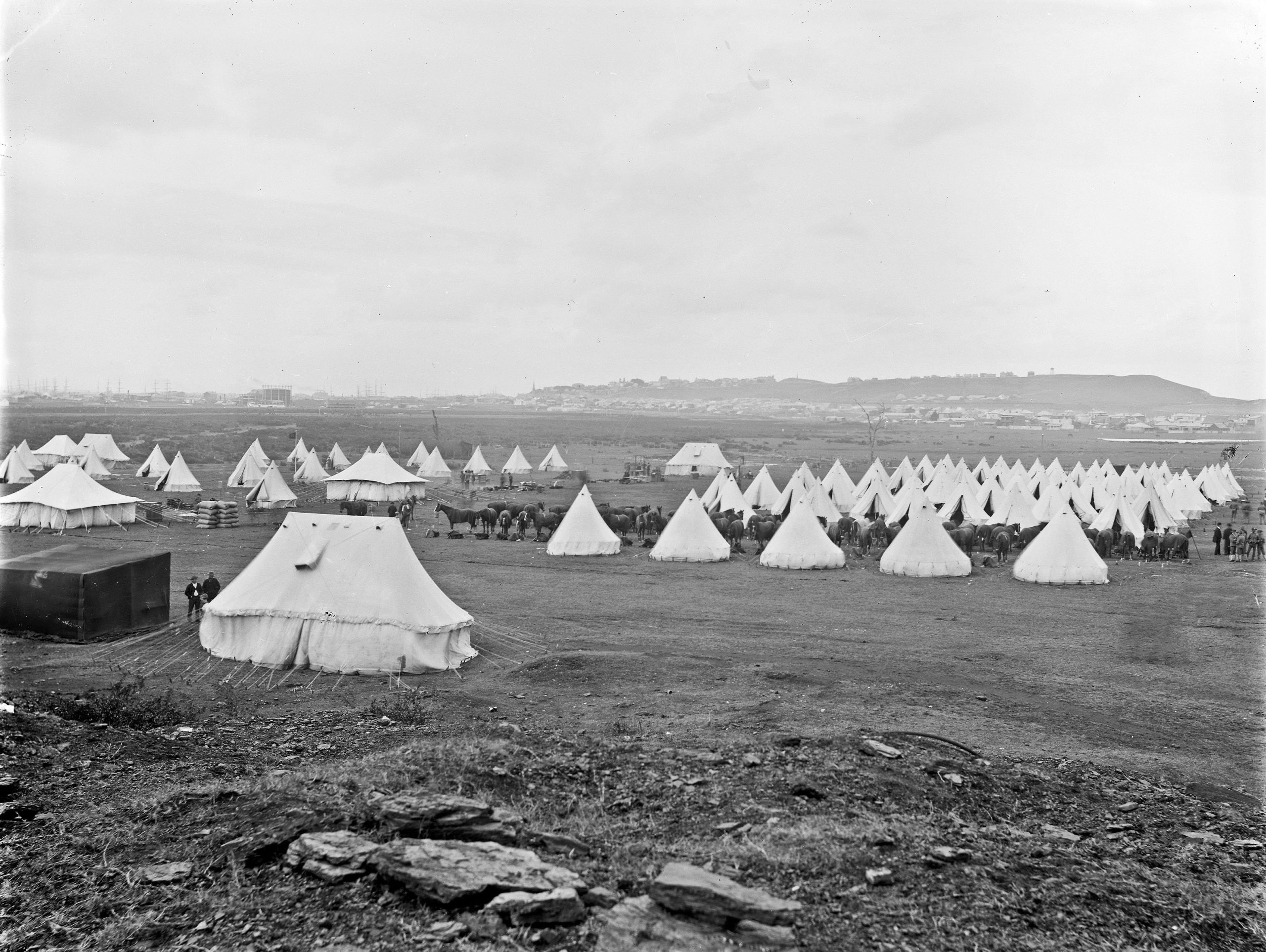
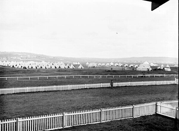
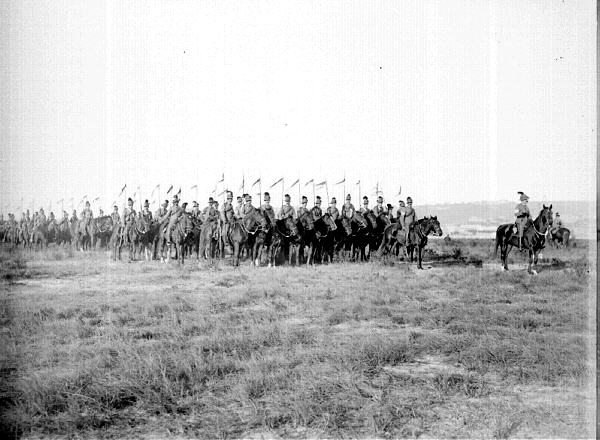
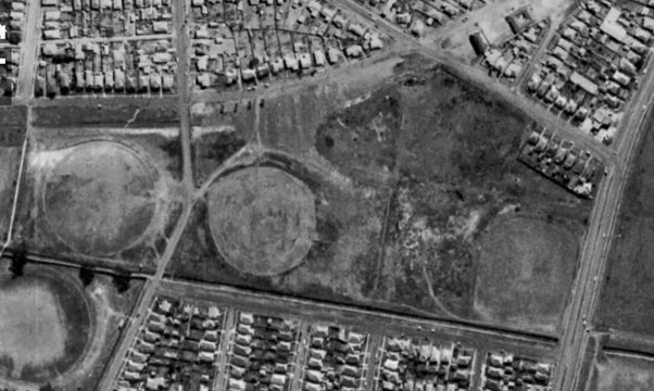
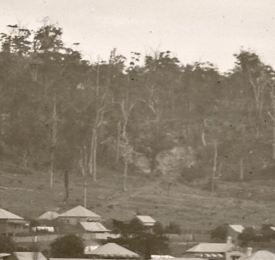
In 1897 a camp was held in the flat area of Hamilton South known as Blackburn’s Oval. This was located near the Merewether Hotel (now the Mary Ellen) operated by Edward Blackburn. Over 60 tents were erected to accommodate 550 men, comprising the 4th Infantry Regiment from Newcastle, a field artillery unit from Sydney, and the mounted No. 3 Lancers Squadron from Singleton and Maitland. The Newcastle Morning Herald and Miners’ Advocate reported that “the four days’ military encampment commenced on Friday night under most unfavourable weather auspices, a strong southerly gale, with pouring rain, rendering the condition of the men under canvas far from pleasant.”
Each day was filled with drills and parades, with the main exercise held on Monday. Woken at 3:30am, the troops formed up on the parade ground and were told of an ‘enemy’ force having landed at Belmont and heading to Newcastle. The infantry, cavalry and artillery proceeded to Charlestown and engaged in a 90-minute mock battle that repulsed the ‘invaders’ in time for breakfast at 8.30am.
Returning to camp and a few hours rest, the soldiers held another exercise in the afternoon. Upwards of 7000 spectators crowded onto the Glebe Hill and the spoil heap of the old Hamilton colliery to watch “the troops rushing to and fro, the cavalry galloping around, with the air thick with smoke as the big guns reverberated.”
The camp ended on Tuesday with general satisfaction at its success, apart from the departing troops’ complaints of “insufficient and commonplace” food rations. Newcastle continued to host annual military encampments in the vicinity, with the last held in September 1914. Blackburn’s Oval was used for sport up until 1923, after which the area was developed for housing.
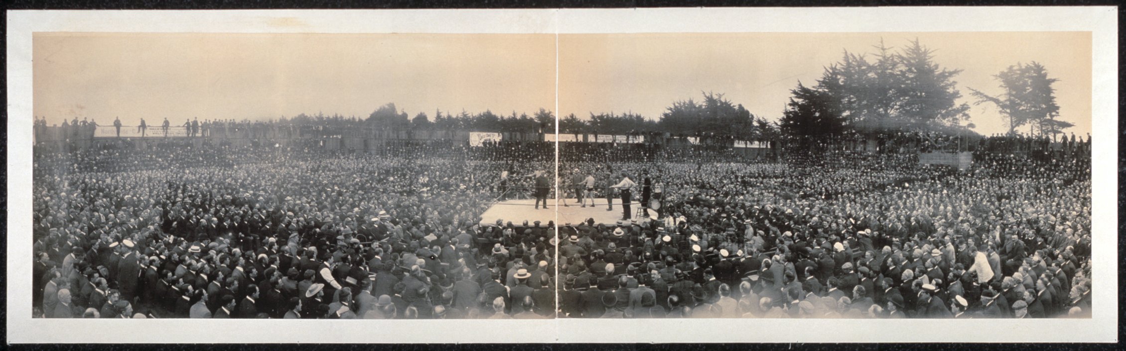
Army Camp Blackburn Oval, Hamilton South, NSW, 23 May 1897. Photo by Ralph Snowball. University of Newcastle, Living Histories.Pacific Highway, Hamilton South. Motorists now drive where the military once drilled.
The article above was first published in the May 2024 edition of The Local.
Additional Photos
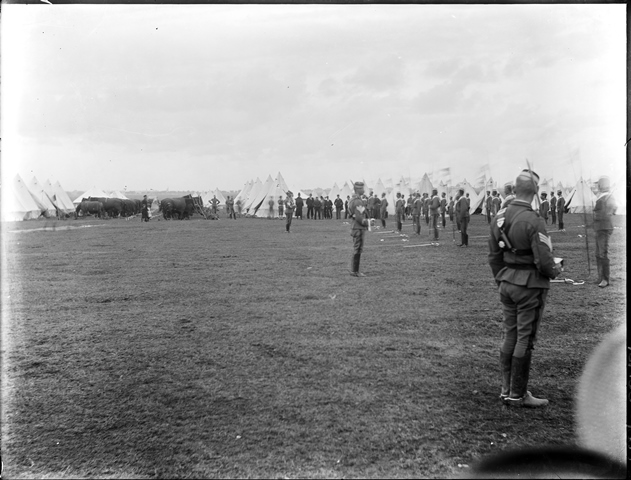
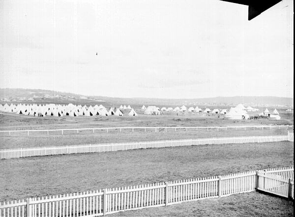
Newcastle Libraries Hunter Photobank has a number of photos of army encampments held in the inner city area. The photograph below is undated in their collection, but it is almost certainly the encampment of 1897.
Army camp (Blackburns Oval), May 1897. Photo by Ralph Snowball. Hunter Photobank, accession number 001 000171
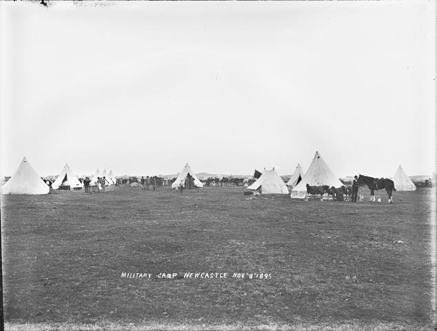
The collection has one photograph of an earlier encampment held in 1895 …
Military camp at Newcastle, 8 November 1895. Photo by Ralph Snowball. Hunter Photobank, accession number 001 001463
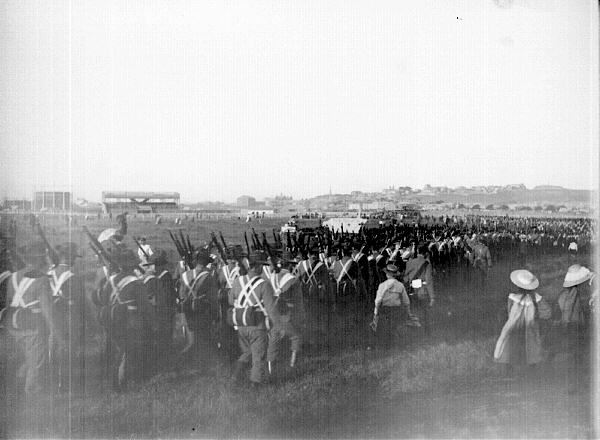
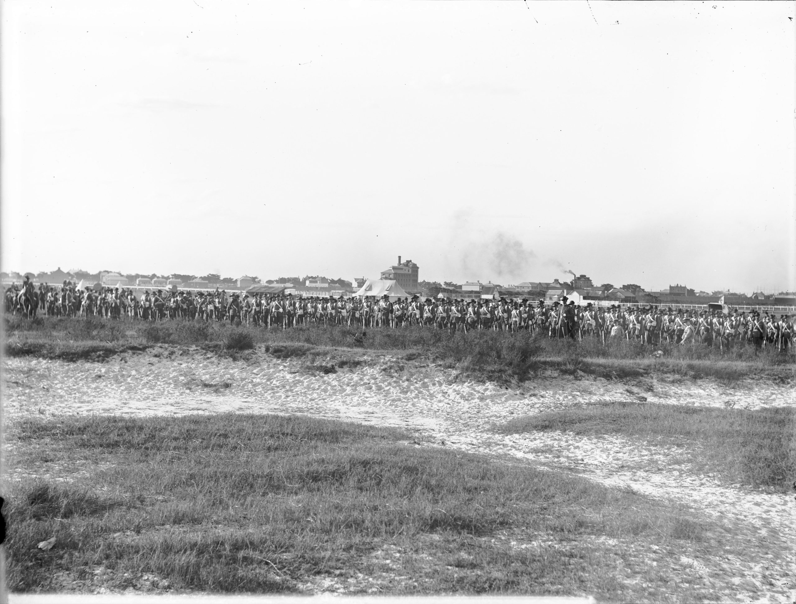
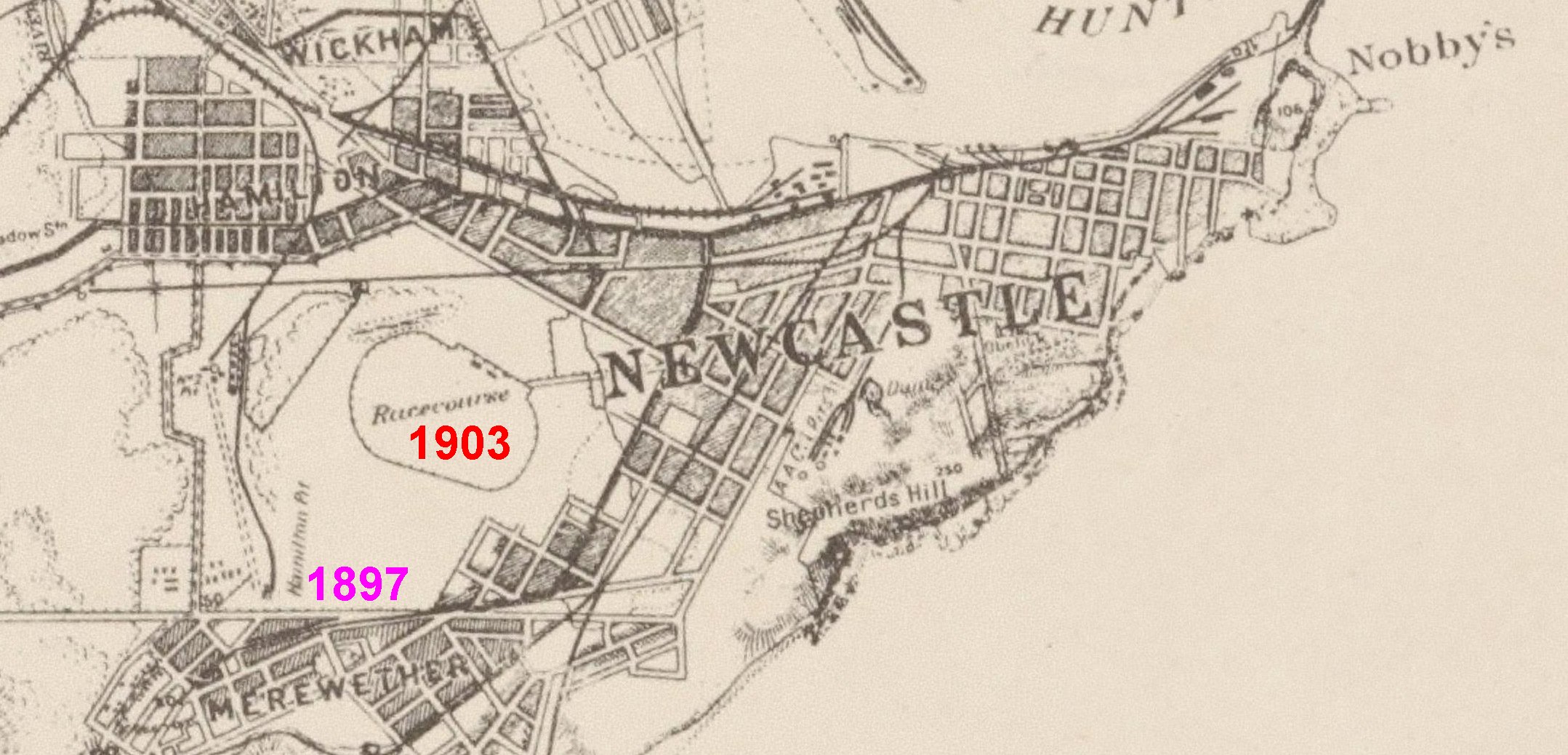
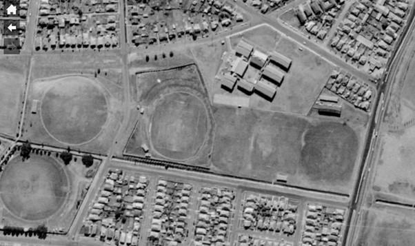
… and multiple photographs of the encampment held on the old racecourse in April 1903.
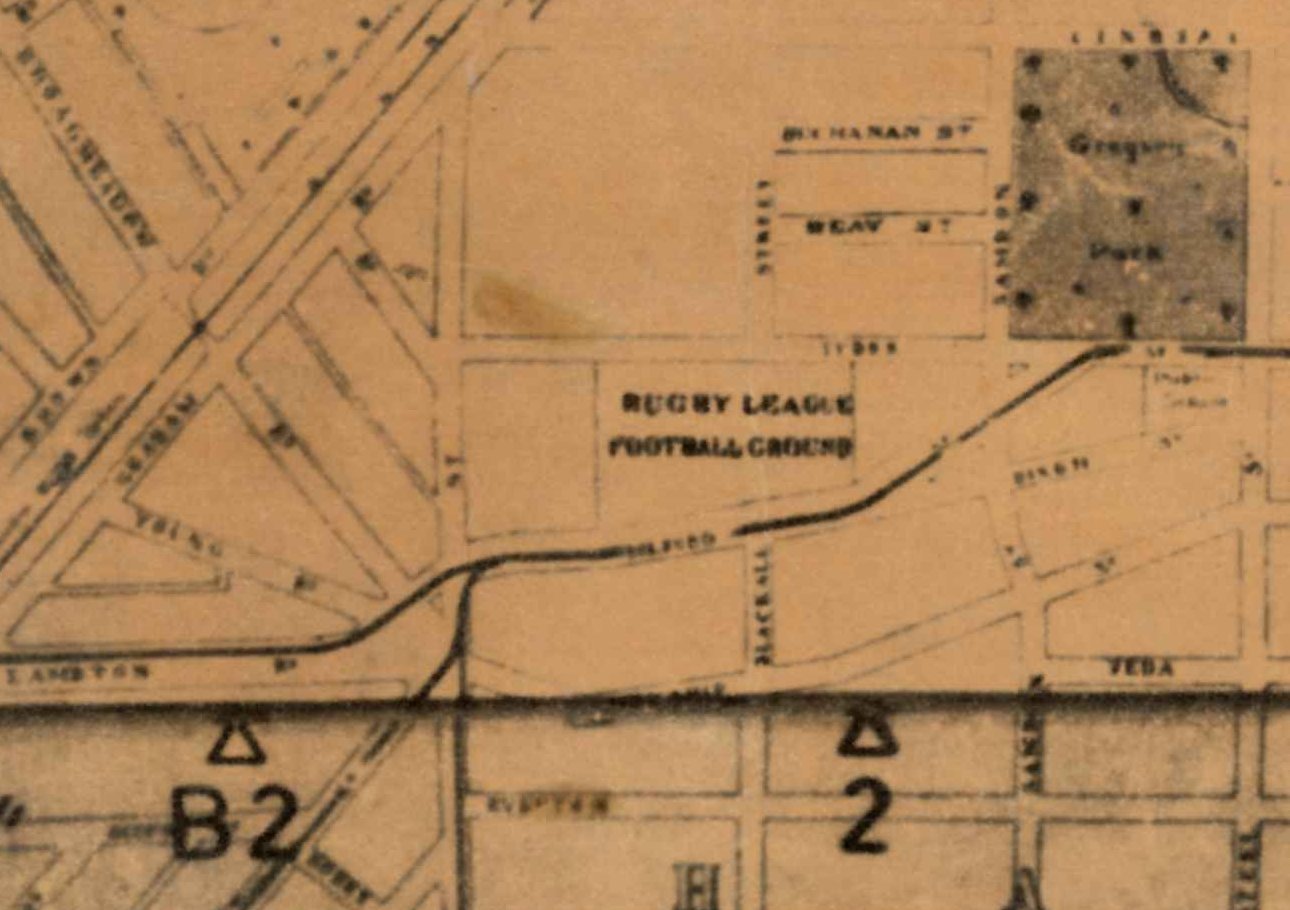
Army encampment at Old Racecourse, Newcastle, 13 April 1903. Photo by Ralph Snowball. Hunter Photobank, accession number 001 001618Army encampment at Old Racecourse, Newcastle, 13 April 1903. Photo by Ralph Snowball. Hunter Photobank, accession number 001 001620Troops at Old Racecourse, Newcastle, 14 April 1903. Photo by Ralph Snowball. Hunter Photobank, accession number 001 001619Troops at Old Racecourse, Newcastle, 14 April 1903. Photo by Ralph Snowball. Hunter Photobank, accession number 0001 001621.Lancers at Old Racecourse, Newcastle, 14 April 1903. Photo by Ralph Snowball. Hunter Photobank, accession number 001 001616Portion of Parrott’s 1893 map of Newcastle, annotated with the position of the 1897 encampment on Blackburns Oval adjacent to the Hamilton Pit, and the 1903 encampment on the old racecourse. National Library of Australia.
Blackburns Oval/Ground
The Lost Football Ground Newcastle website has a good summary of Blackburn’s Oval/Ground. Edward Blackburn became the licensee of the Merewether Hotel in August 1893, and continued until September 1907 when his licence was cancelled after receiving three convictions in three years. The first mention I can find in Trove to Blackburn’s Oval/Ground is 4 Apr 1900, and the last mention on 10 September 1923.
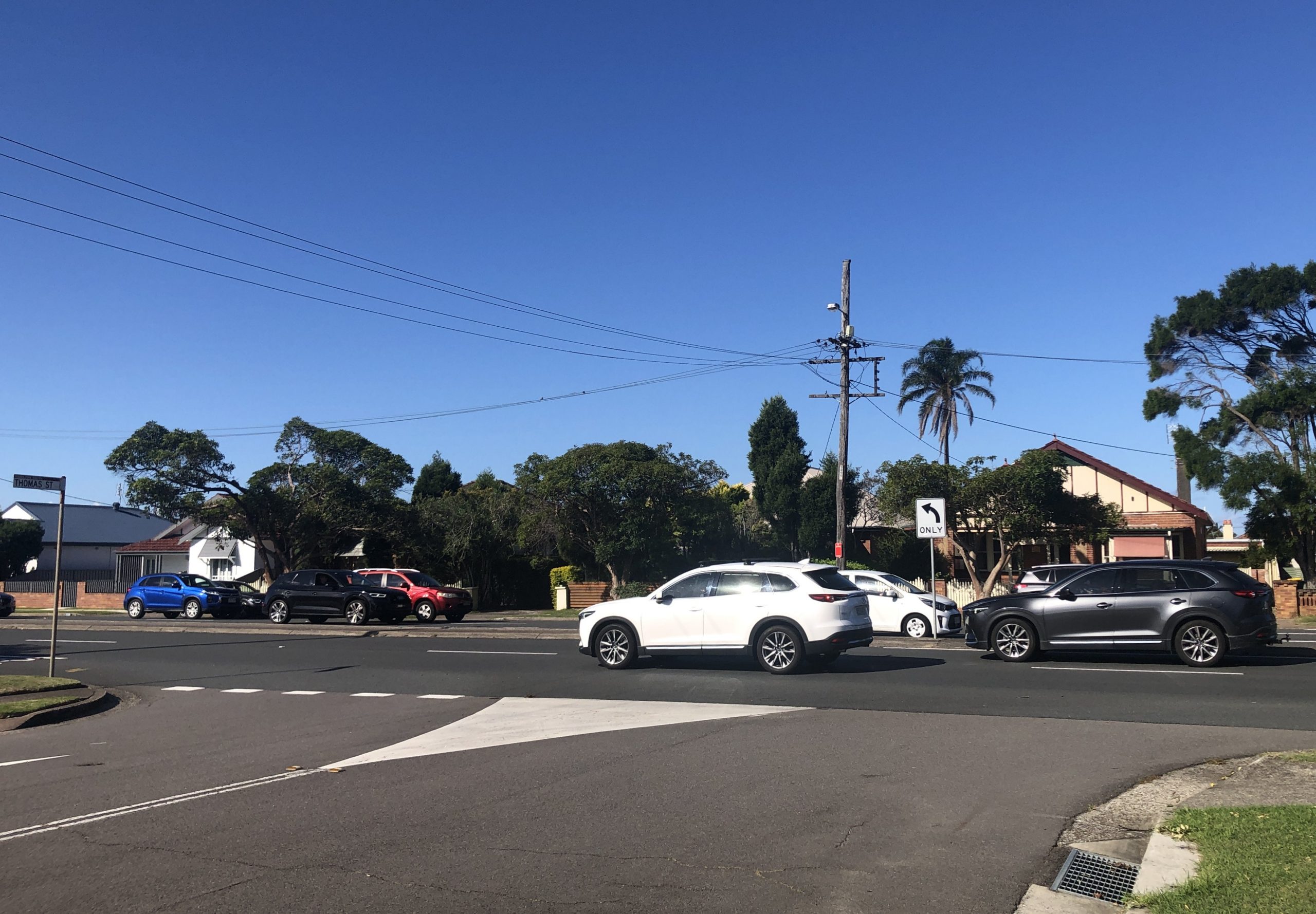
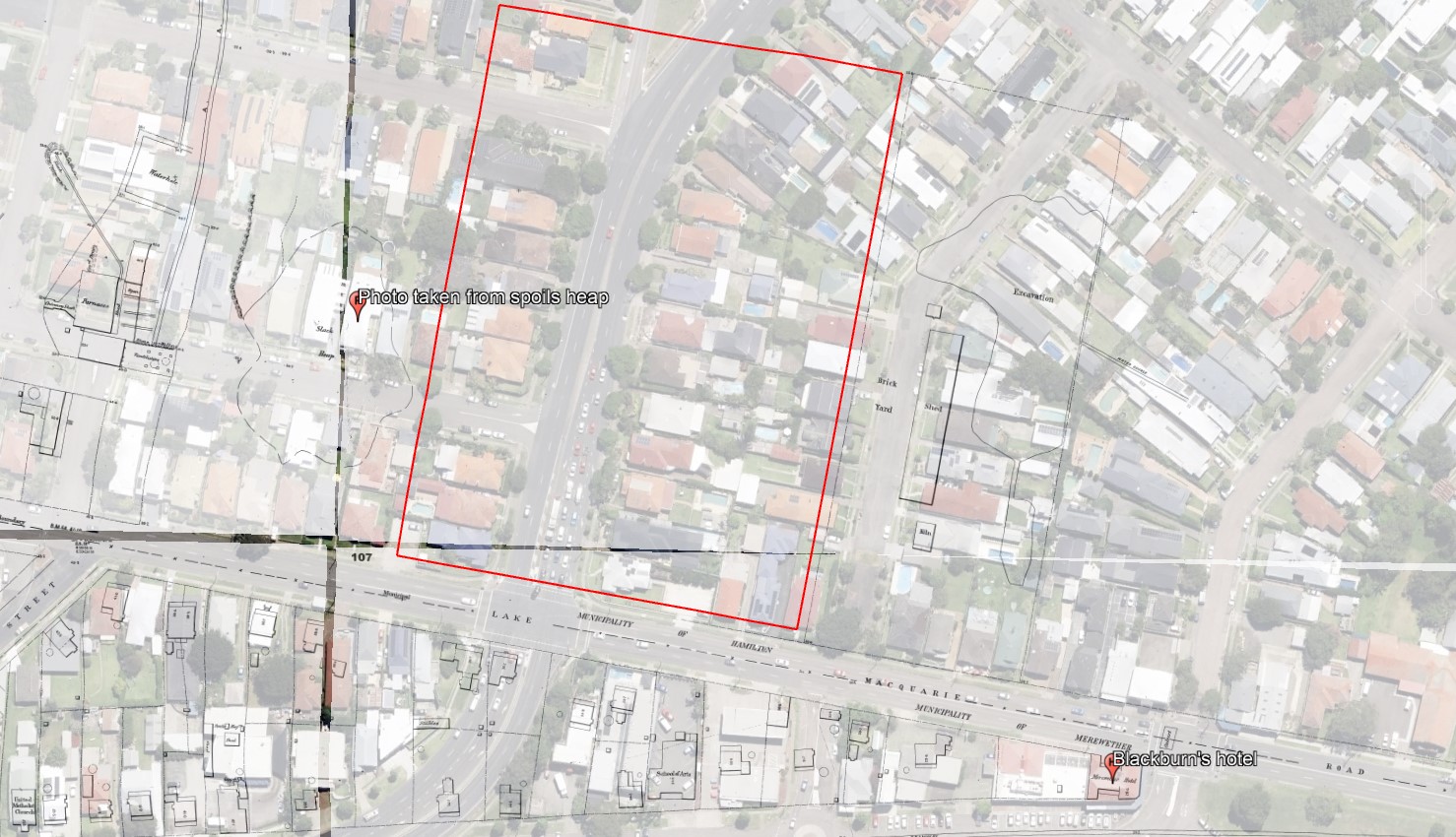
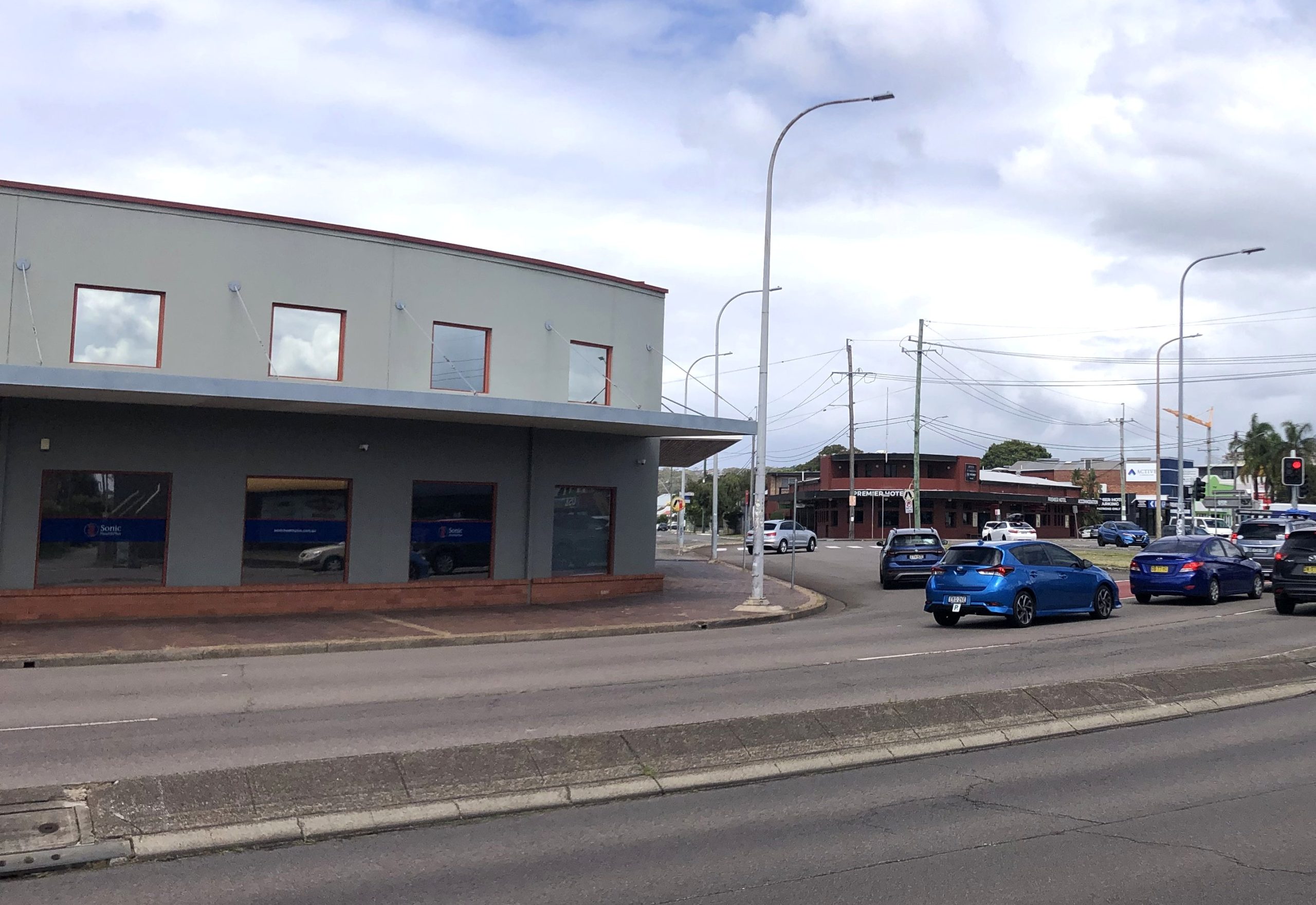
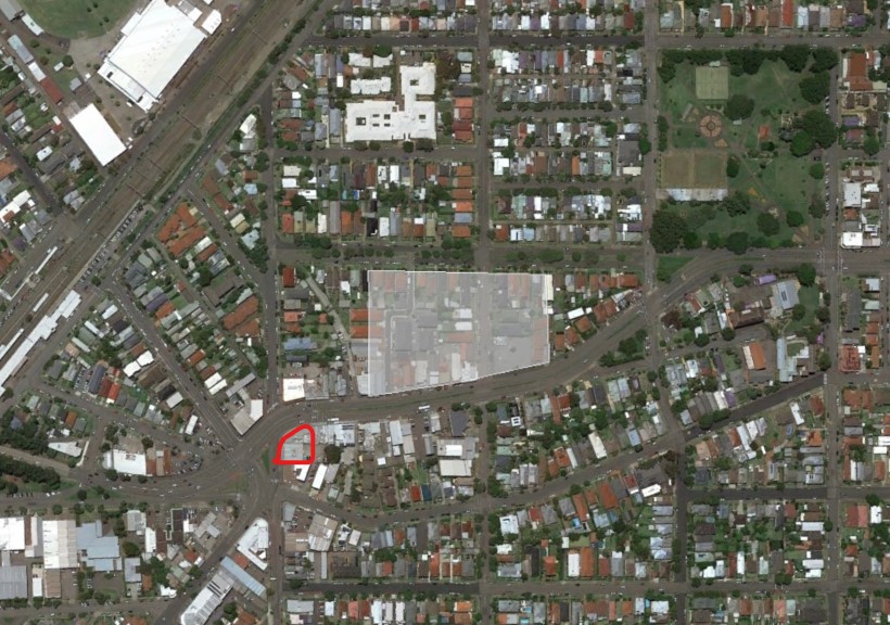
Overlaying old Water Board maps into Google Earth, we can see that the Hamilton Pit slack (spoils) heap from which Snowball’s photo was taken, was located in the vicinity of where Thomas St is today. Thus the army encampment was in the area where the Pacific Highway passes through today.
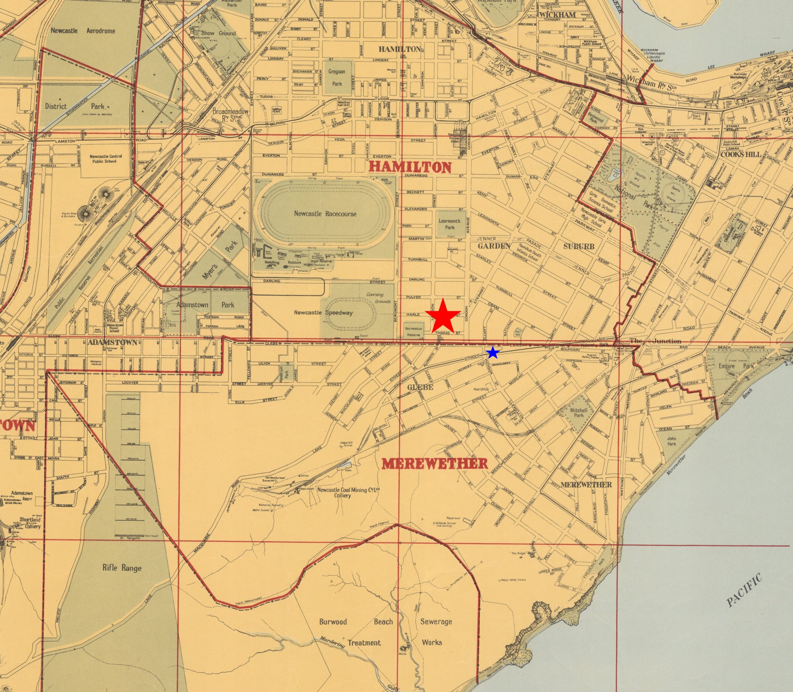
Note that reports of the army encampment of 1897 variously describe it as being in Hamilton or Merewether. Edward Blackburn’s hotel was located on Glebe Rd on the northern edge of the Merewether municipality. Thus across the road, the sporting ground known as Blackburn’s Oval was located in the Hamilton municipality.
Craigies map with the municipal districts of Newcastle (red borders) that shows Blackburn’s hotel (blue star) was in Merewether, while Blackburn’s Oval across the road (red star) was in Hamilton. National Library of Australia.
Appendix – Date of the Snowball photograph
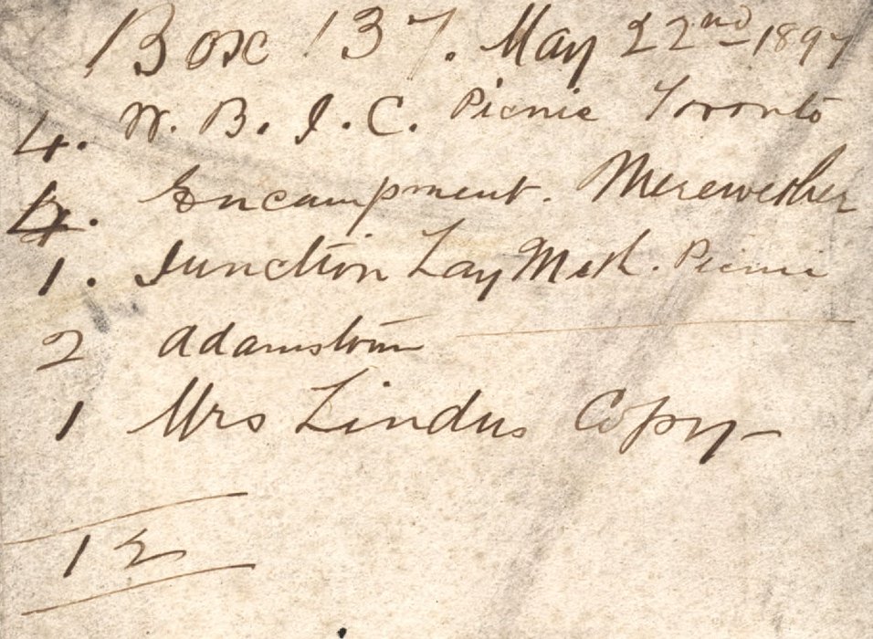
The Ralph Snowball photograph of the army encampment from the Living Histories site used in this article, originally had a date of 23 May 1899. After researching for this the article I am certain that the correct date is 23 May 1897, for the following reasons.
Searching Trove for information about army encampments in May 1899 reveals no results.
Searching Trove for information about army encampments in May 1897 reveals lots of articles, with details that align with the photograph – its location next to the spoil heap of the Hamilton Pit, the number of tents, the presence of infantry and cavalry.
The listing for Box 137 of Snowball’s glass plates that commences on 22 May 1897, shows four photographs taken of “Encampment, Merewether”.
Ralph Snowball Box 137 listing. Newcastle University, Living Histories.
I have subsequently corrected the date in the Living Histories site.
"On Thursday 38 men were inspected by Warrant-officer Thompson and passed into the ranks of the Singleton Half-Squadron of Lancers, which is now, therefore, duly formed."
"A communication was read from the officer commanding the 4th Infantry Regiment, asking in the event of an encampment for between 500 and 600 men being held at Merewether, on the 22nd to the 25th instant, if arrangements could be made for supplying water at a spot indicated on a plan which accompanied the letter. Under the circumstances it was decided to grant a free supply of water, and also lend a meter to check the consumption; but all the required pipes and connections would have to be supplied by the military authorities, and the work carried out at their expense by a licensed plumber."
"Captain Hilliard, the military staff officer for Newcastle, having completed the surveying in connection with the encampment for the No. 3 Squadron New South Wales Lancers and the 4th Infantry Regiment, to be held at Merewether on 22nd, 24th, and 26th inst., Captain Luscombe yesterday had a fatigue party at work putting up the tents. It is expected that the whole of the arrangements will be completed by to-morrow evening."
"In view of the contemplated encampment of the volunteer forces of the northern district, to be held during this and part of next week, the scene of operations, adjoining the A.A. Co.'s Hamilton pit, has undergone a complete transformation. Upwards of 60 tents have been erected, giving the place a very picturesque appearance."
"The officers and troops from Morpeth West Maitland, and East Maitland who are to take part in the military encampment arrived at Honeysuckle Point station by special train at 8.37 last evening, and marched off at once to Merewether to camp under canvas for the night, with the elements anything but favourable to camping out."
"The military encampment at Merewether commenced last night, and despite the unpropitious state of the weather it was expected that 550 men of all ranks would be under canvas. These consist of the A B D E and H Companies, who will be reinforced by two guns from A Battery Field Artillery, who will arrive here by special train today from Sydney. The Maitland and Singleton Lancers will arrive by train to-day to take part in the proceedings."
"The four days' military encampment at Merewether commenced on Friday night under most unfavourable weather auspices, a strong southerly gale, with pouring rain, rendering the condition of the men under canvas far from pleasant."
"The military encampment at Merewether attracted a large number of visitors yesterday. The particularly fine specimens of horseflesh to be seen in the Lancers' lines excited considerable admiration among the visitors.” At Fort Scratchley and Shepherd's Hill "there will be shot practice by the No. 6 Company at a target to be moored at sea. Residents in the neighbourhood are reminded to open their windows, to avoid them being broken by the force of the concussion."
"Those who considered that a military encampment would have no attraction for the general public must, after yesterday's experience, admit that they are very bad judges of the public taste. From an early hour in the morning, crowds began to gather at the Merewether camp, comprising men, women, and children of all ages and sizes, and, as the day wore on the numbers increased rapidly. After 2 o'clock, when the grand attack was commenced in the direction, of Hamilton, the Glebe Hill and the slack heap of the old Hamilton pit were literally black with people. There could not have been less than 7000 spectators, and though few, if any, really knew what was going on to cause the troops to be rushing to and fro and the cavalry to be galloping around the outskirts of the attack formations." "The air at one time was thick with smoke, and still the reports of the big guns reverberated."
"The encampment at Merewether was broken up yesterday afternoon, the whole of the troops, headed by the 4th Regiment Band, marching out shortly after half-past 4 o'clock, fairly tired out after their few days' continuous training."< /br>
"There would, however, need to be better commissariat arrangements. The rations allowed to the men during this camp have been insufficient … The meals, though wholesome, were of a common-place description, and those who required drinks - other than tea and water - had to pay for them. On the whole the camp was run with more than a due regard to economy, and it would not be out of place if an effort were made before next year to stretch the Government purse strings in this matter."
"The troops who have just come out of the encampment hope that arrangements will be made by which they shall get more liberal rations when they next go under canvas."
"All the paraphernalia used in connection with the late encampment was brought into the city yesterday and stored in the drill hall of the military buildings in Hunter street."
"An immediate, and strong protest should be made against the determination of the military authorities to abolish the Newcastle encampment, and to centre the large number of recruits from Newcastle and the northern district in Sydney."
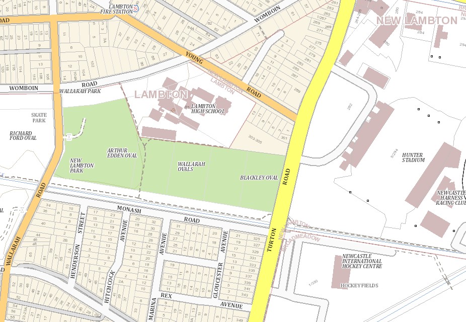
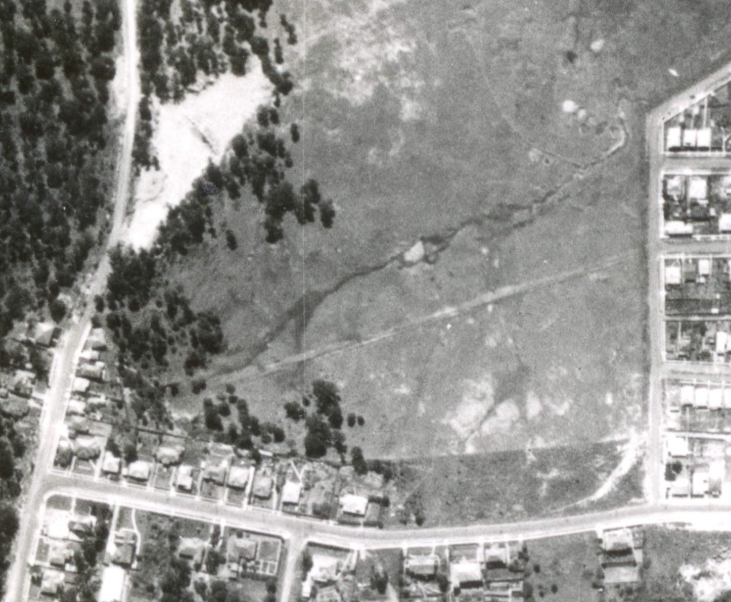
A reader of this blog recently asked me about the history of the land where Wallarah and Blackley Ovals are located in New Lambton on Turton Rd. This is of relevance because of the current proposal to build a new basketball stadium on the site, resulting in the loss of two sporting fields. While there appears to be overwhelming consensus that a new basketball stadium is needed for Newcastle, there are many who are opposed to the Turton Rd site. (For my own view, read on to the end of this article.)
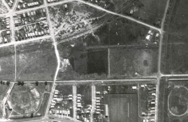
Wallarah and Blackley Ovals in New Lambton. SIX Maps
The area where the ovals are located was originally part of the Newcastle Pasturage Reserve, also known as the Commonage. As the name suggests, it was intended for the pasturing of livestock. Although many people illegally built houses on the commonage land, virtually no housing was built on low level ground near waterways, because of flooding. From 1889 the NSW government began to sell off Commonage land.
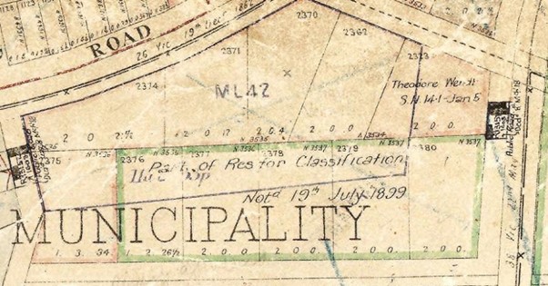
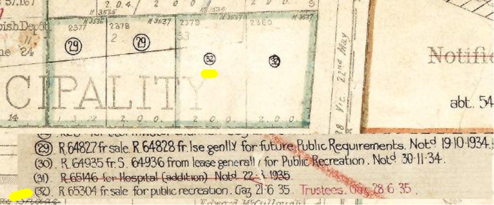
The government legally dedicated (gazetted) various bits of land for particular purposes at various times. The first reference I can find to the Blackley Oval land was in 1899, when on 26 Apr 1899 Homestead Selection Area 585 was gazetted. This consisted of multiple portions of land within the Newcastle Pasturage Reserve, including portions 2376 to 2380. But curiously just a few months later on 19 Jul 1899, Homestead Selection Area 585 was revoked, and the government retained ownership of the land.
Parish map showing revocation of Homestead selection area of portions 2376 to 2380 on 19 July 1899. Historical Land Records Viewer
Although sale of Commonage land into private hands had been happening since 1889, a 1910 map shows almost no houses alongside the waterway – but mainly parks and pastures. The area of Blackley/Wallarah ovals is marked with the symbol for “Pasture and Furze”.
In 1948, Newcastle Council approved the naming of “Blackley Oval” …
An application by Newcastle Police and Citizens’ Boys’ Club to have land at District Park known as Quinlan and Blackley Ovals (previously Nos. 9 and 10 ovals) vested in the club was granted by Greater Newcastle Council last night.
Newcastle Morning Herald and Miners’ Advocate, 17 March 1948.
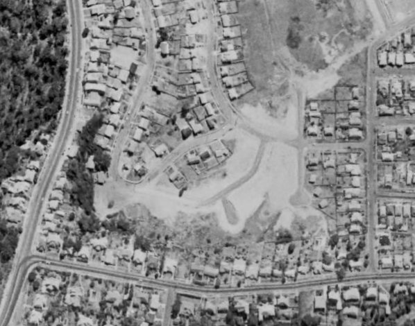
This snippet indicates that Blackley Oval originally had the unimaginative name of “No. 10 Oval”. Was the No. 9 oval (renamed to Quinlan oval) the field to the west of Blackley Oval? If so when and why was it renamed to Wallarah Oval? I suspect it was not, as a 1954 aerial photograph shows that the only field north of the drain is Blackley Oval.
The Geographical Names Board assigned the name “Wallarah Ovals” to the sporting reserve in December 1977.
My view on the proposed location
Like most people, I agree that a new basketball stadium is needed. But I strongly disagree with the currently proposed location on Turton Rd, for three main reasons.
Green space is precious. Once green space is lost to development, it is never regained. With global temperatures rising, if we are to have cities that are pleasant to live in we must be super vigilant and protective of green space.
The proposal benefits one sporting code at the expense of other sporting codes who currently use those fields. The proposal is a “rob Peter to pay Paul” scenario.
Parking and traffic in the area is already problematic when there is a big event on at Hunter Stadium. If the basketball stadium was built across the road, and both venues had an event at the same time the traffic situation would be a nightmare.
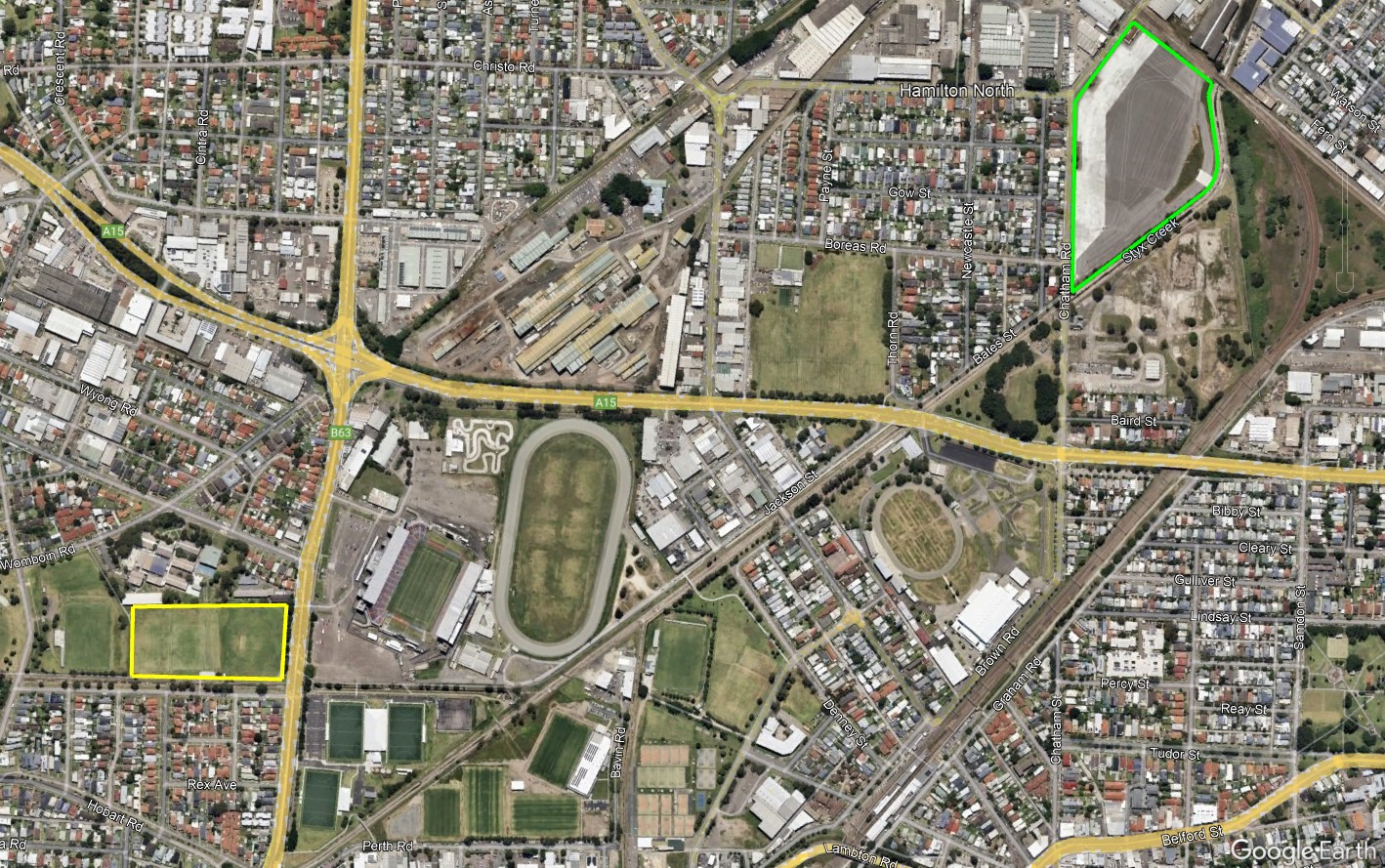
So if not Turton Rd, then where could a new basketball stadium be built? Looking at the map I wonder about the old gasworks site in Hamilton North. It’s close to the sporting/entertainment precinct at Broadmeadow, is close to public transport, does not take away green space, and has oodles of room for parking. There may be good reasons why this location is not practical (cost, availability, engineering limitations), but it would be worth considering.
Proposed site of new basketball stadium in Turton Rd. (Yellow outline). Possible location in Hamilton North? (Green outline). Google Earth.
Within a year of New Lambton beginning in 1868, residents had erected two church buildings, the Lay Methodists in Rugby Road and the Wesleyan Methodists in Victoria Street. Members of the Anglican Church however had no place to meet and had to travel to neighbouring Lambton to worship at St Johns church. This situation endured for many decades, although by 1918 the New Lambton Anglicans were at least catering for children by running a Sunday School in the Mechanics’ Institute hall.
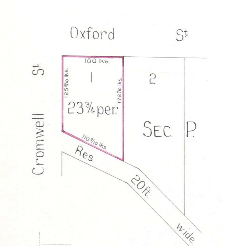
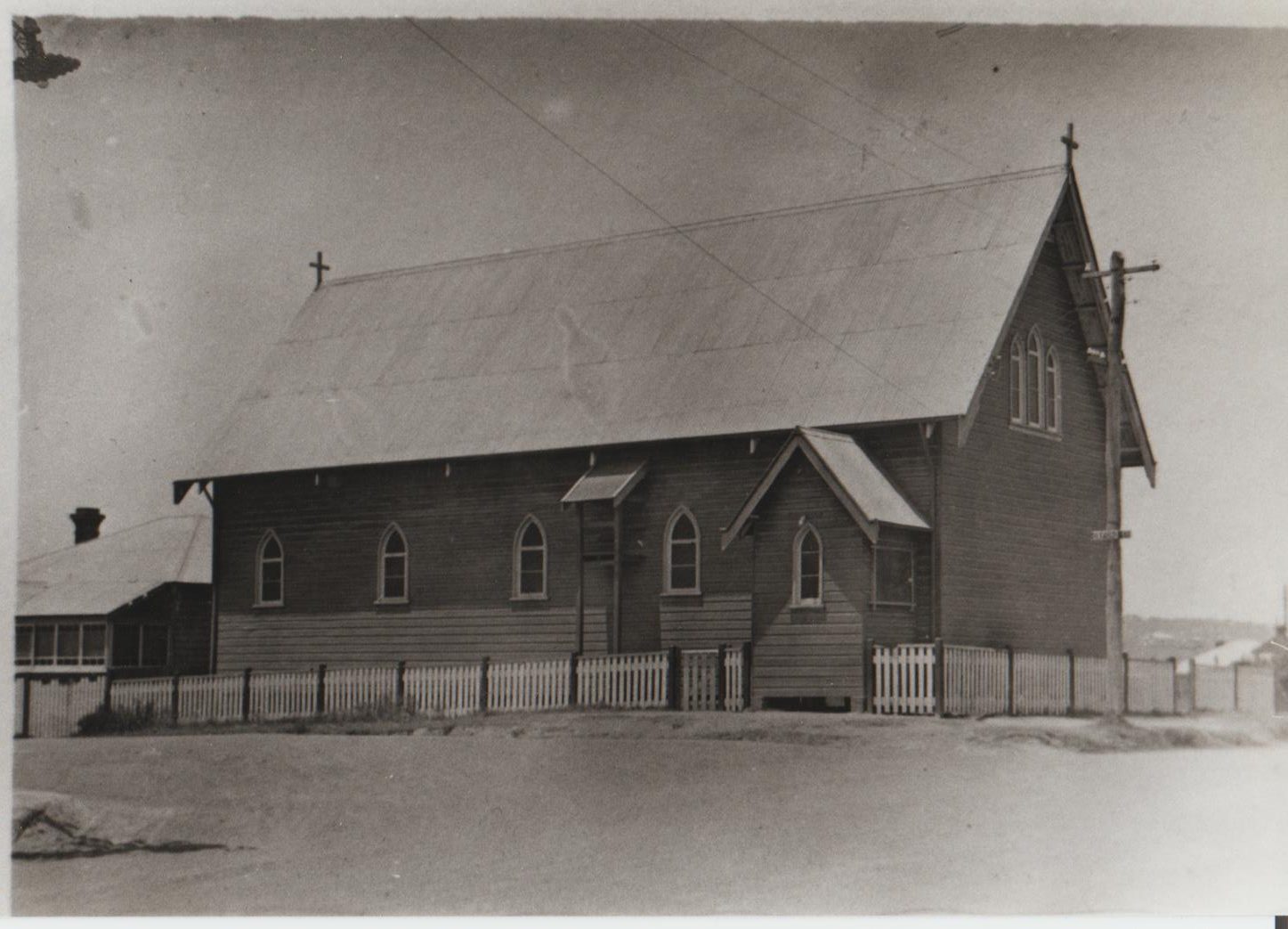
In 1924 the first Anglican Church building in New Lambton was erected on the corner of Cromwell and Oxford Streets. Costing £750, it was “of the Gothic architecture, constructed of rusticated weatherboard, 60 feet long by a width of 24 feet.”
At the dedication service on 26 April 1924, the bishop of Newcastle, Dr Reginald Stephen declared to those present that “it was going to be used for the worship of God, to pray for themselves and for others” and that “the building was intended to be a blessing to the whole neighbourhood.”
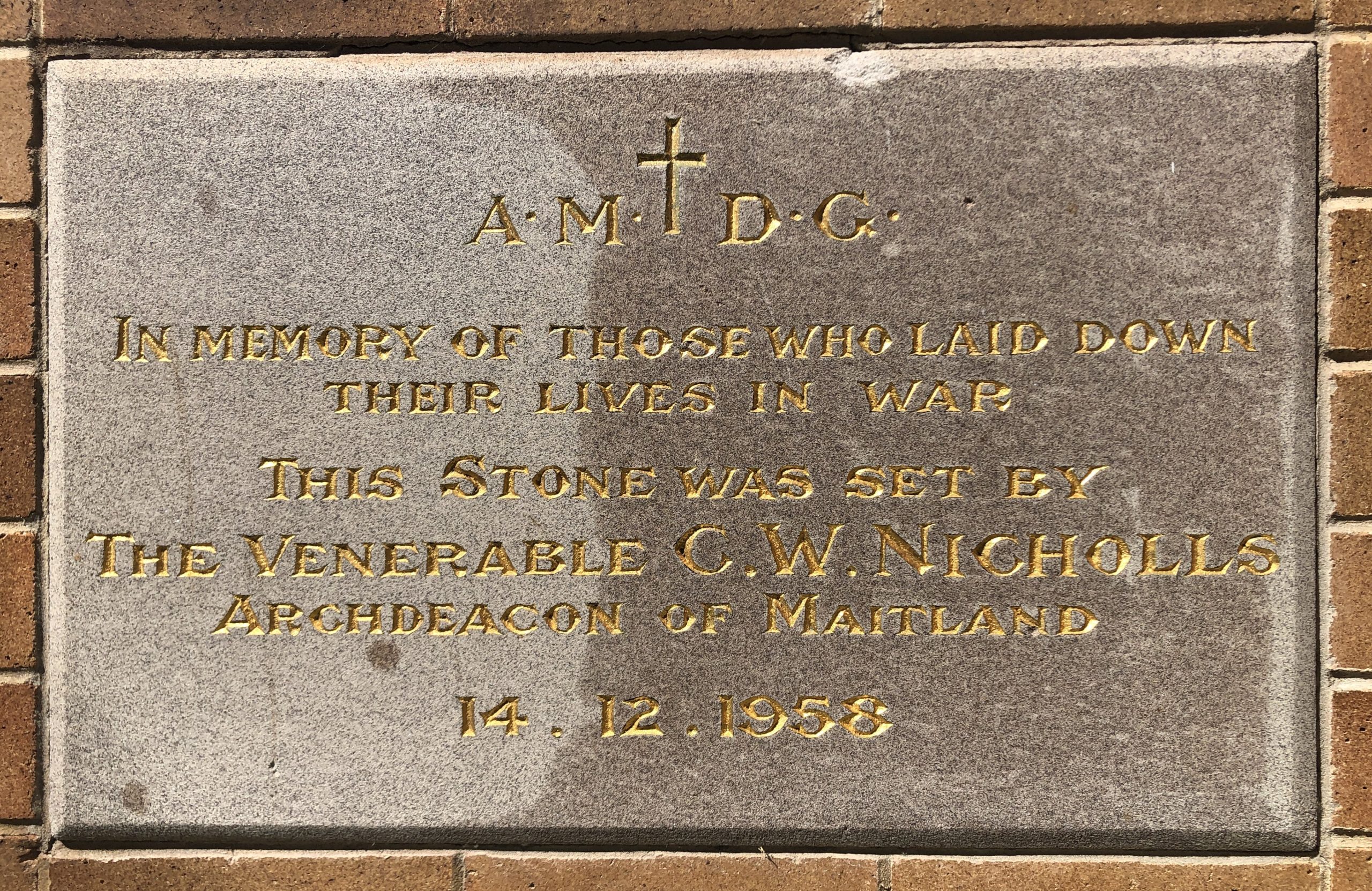
The new church, given the name All Saints, was still part of the Lambton parish. However, growth in the congregation meant that four years later in November 1928, New Lambton became a separate parish and appointed their first rector, the Reverend Hugh Linton.
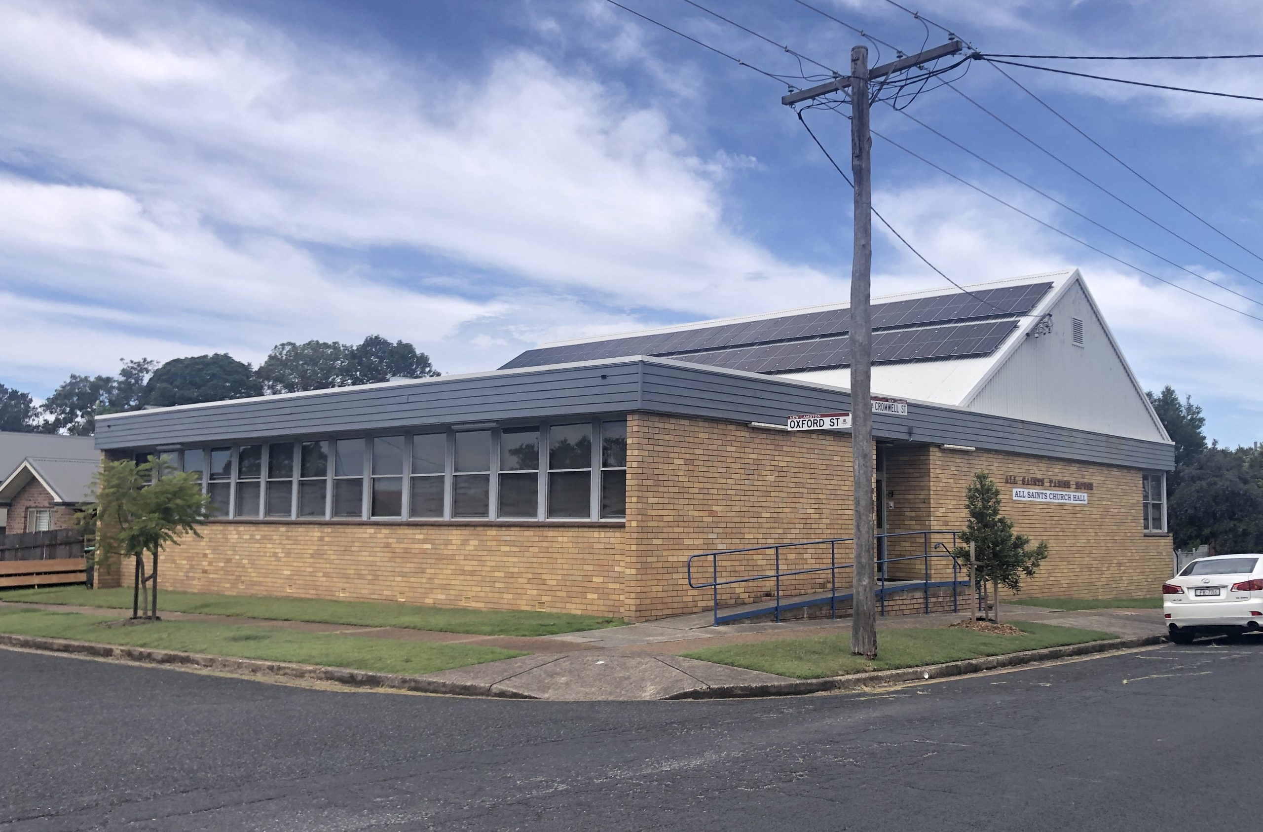
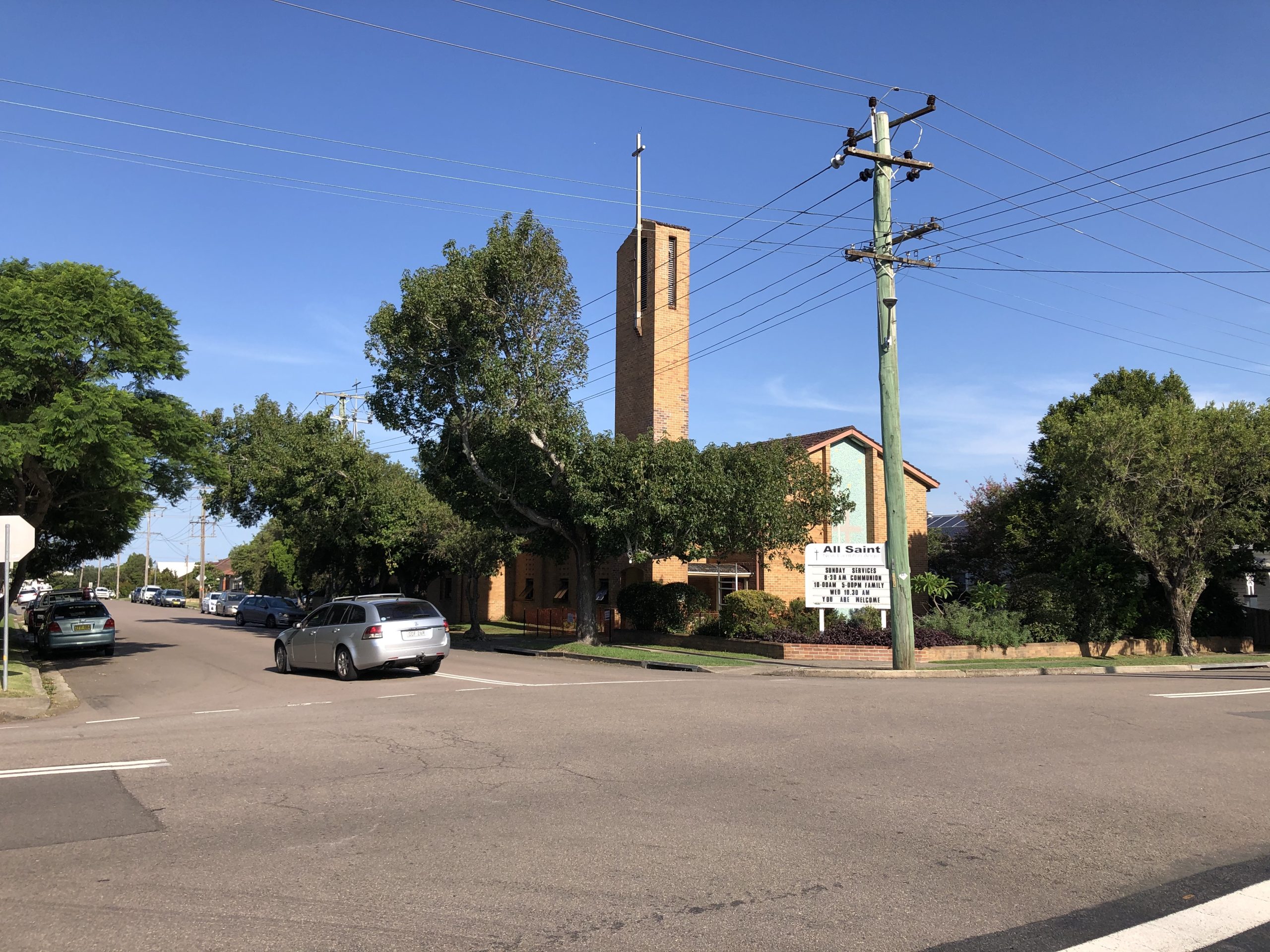
In 1958 the Anglicans purchased a large block of land on the corner of Regent Street and St James Road and erected a spacious brick building. The Newcastle Morning Herald reported that over 1000 people attended the opening service in September 1959. Around 1970, the original wooden church on Cromwell Street was demolished, and the current brick hall and parish office erected in its place. In 2024, one hundred years from opening their first church building, New Lambton Anglicans are undertaking major renovations and refurbishment of the Regent Street building, making it ready for the next hundred years of being a blessing to the neighbourhood.
The original All Saints New Lambton church building erected in 1924. Photo from the collection of Thomas Ernest Millington, via Lyn Millington.The All Saints church office and hall now occupies the site on the corner of Cromwell and Oxford Street.
The article above was first published in the April 2024 edition of The Local.
Additional Information
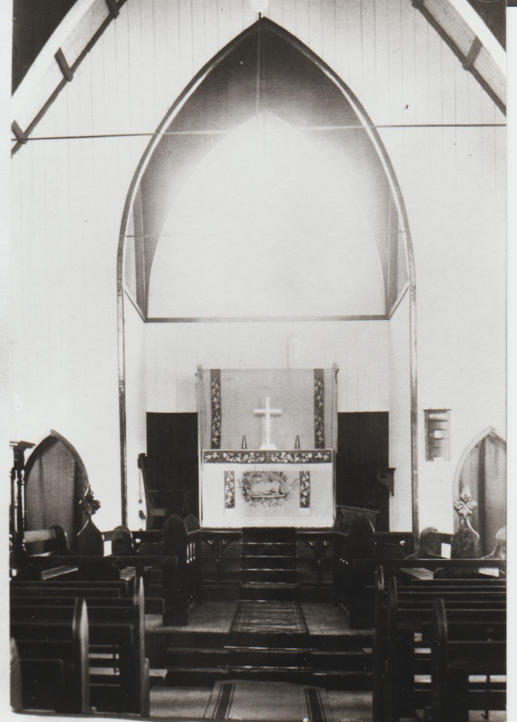
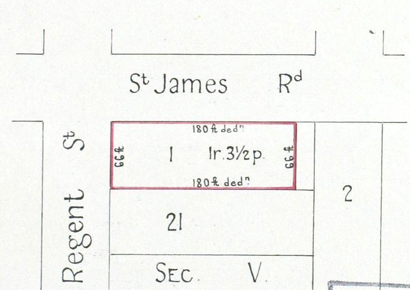
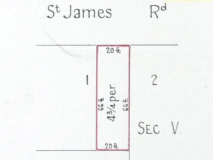
The Anglican Diocese of Newcastle purchased land at the corner of Cromwell and Oxford Streets on 25 August 1913. Vol-Fol 2397-69Interior of All Saints church building, New Lambton. Date unknown. Photo courtesy of Lyn Millington.The original wooden All Saints church building at New Lambton. The photo is undated but must be before 1937, as the parish hall to the right of the church has not yet been erected. Photo courtesy of Lyn Millington.The foundation stone of the first parish hall was laid on 24 October 1937. The stone was retained in the foyer of the new brick parish hall that was erected around 1970.Aerial photograph from 1938, showing the 1924 church (red), newly erected parish hall (green), and the block of land where the current church would be erected (yellow) completely vacant apart from one small shed. Living Histories, University of Newcastle.The Anglican Diocese of Newcastle purchased land at the corner of Regent St and St James Road in July 1958. Vol-Fol 3546-230A small 20 feet wide block of land that was originally part of Lot 1, Sec V, DP 1949 had previously been purchased in April 1958. Vol-Fol 3546-224The foundation stone of the new brick church building on the corner of Regent St and St James Rd was laid on 14 December 1958.
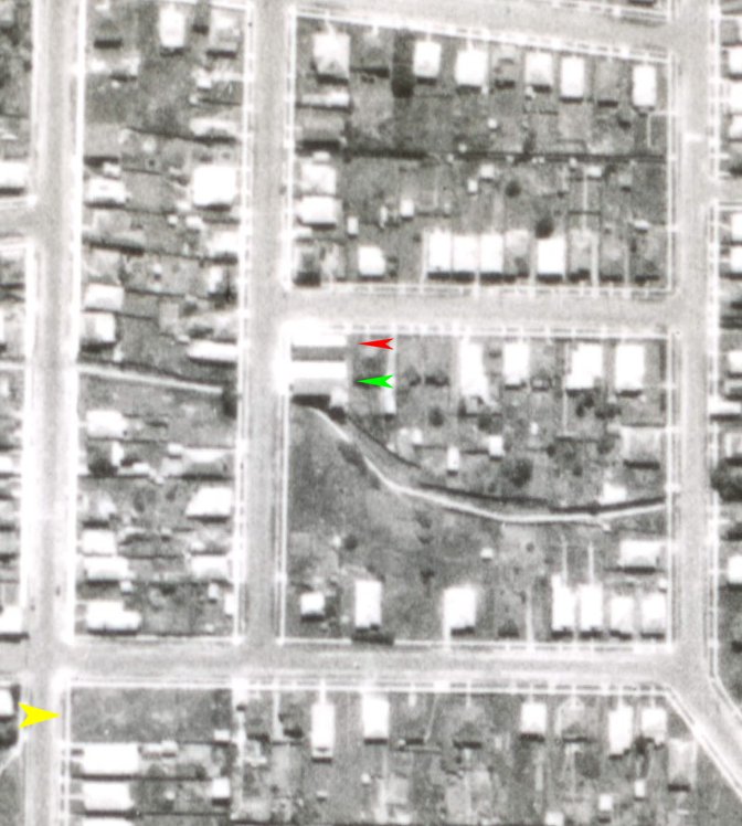
The exact dates when the original wooden church and parish hall was demolished, and new brick parish hall erected in its place is not known. Looking at aerial photographs at NSW Historical Imagery website shows that the demolition/erection occurred sometime between 1966 and 1974.
A 1966 aerial photo showing the original wooden church building (red) and parish hall (green).
A 1974 aerial photo showing the new brick parish hall of All Saints New Lambton.
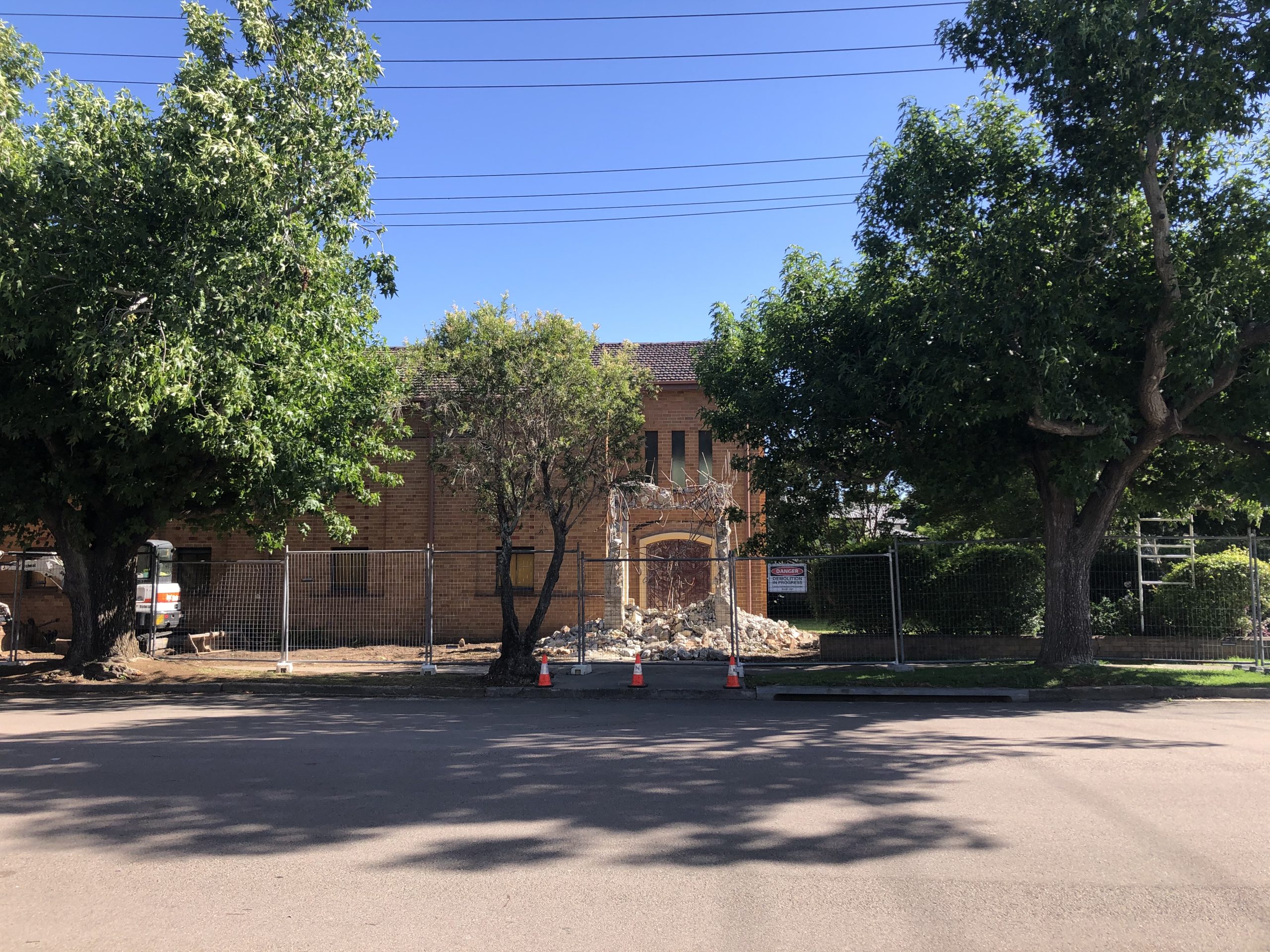
In 2020 major structural defects were discovered in the brick bell tower, posing a significant safety hazard.
All Saints Church, March 2020.
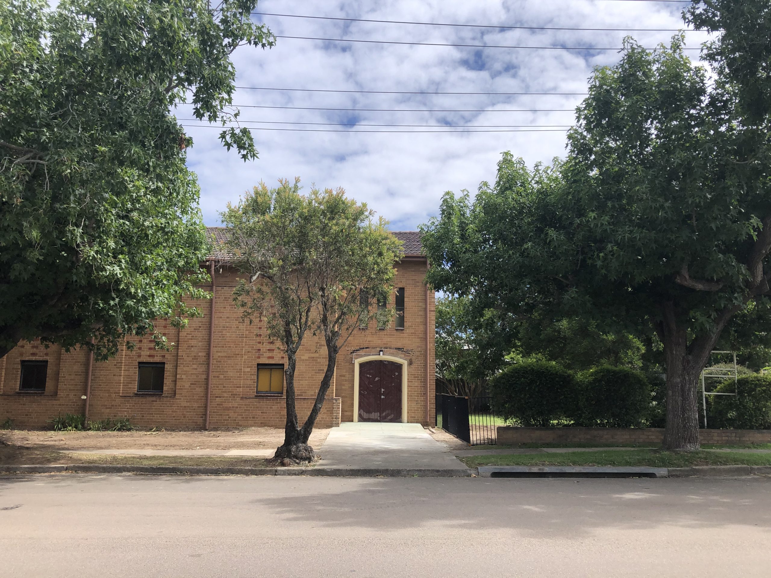
In December 2020 the bell tower was demolished.
The demolition of the bell tower in progress, 1 December 2020.Entrance to the church after the bell tower demolition. 12 December 2020.
The church that never was
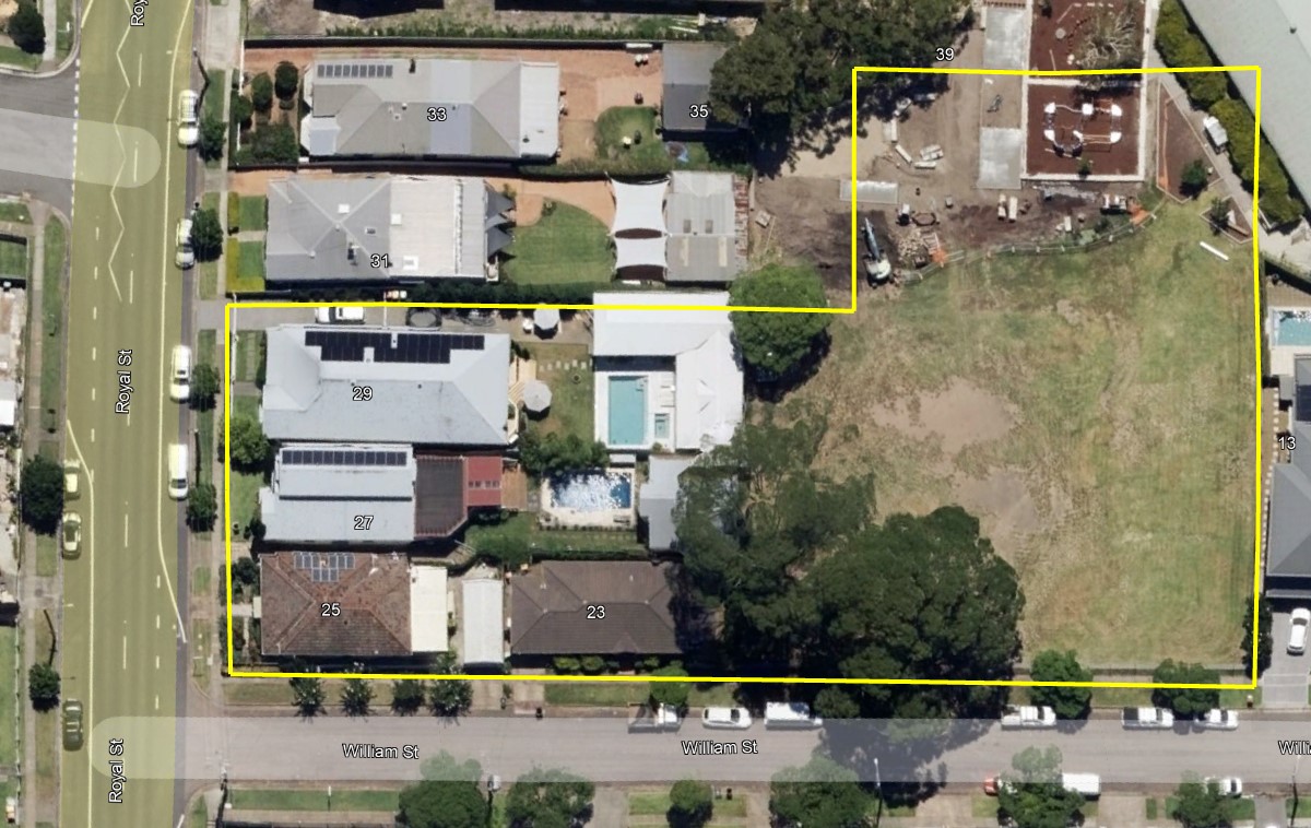
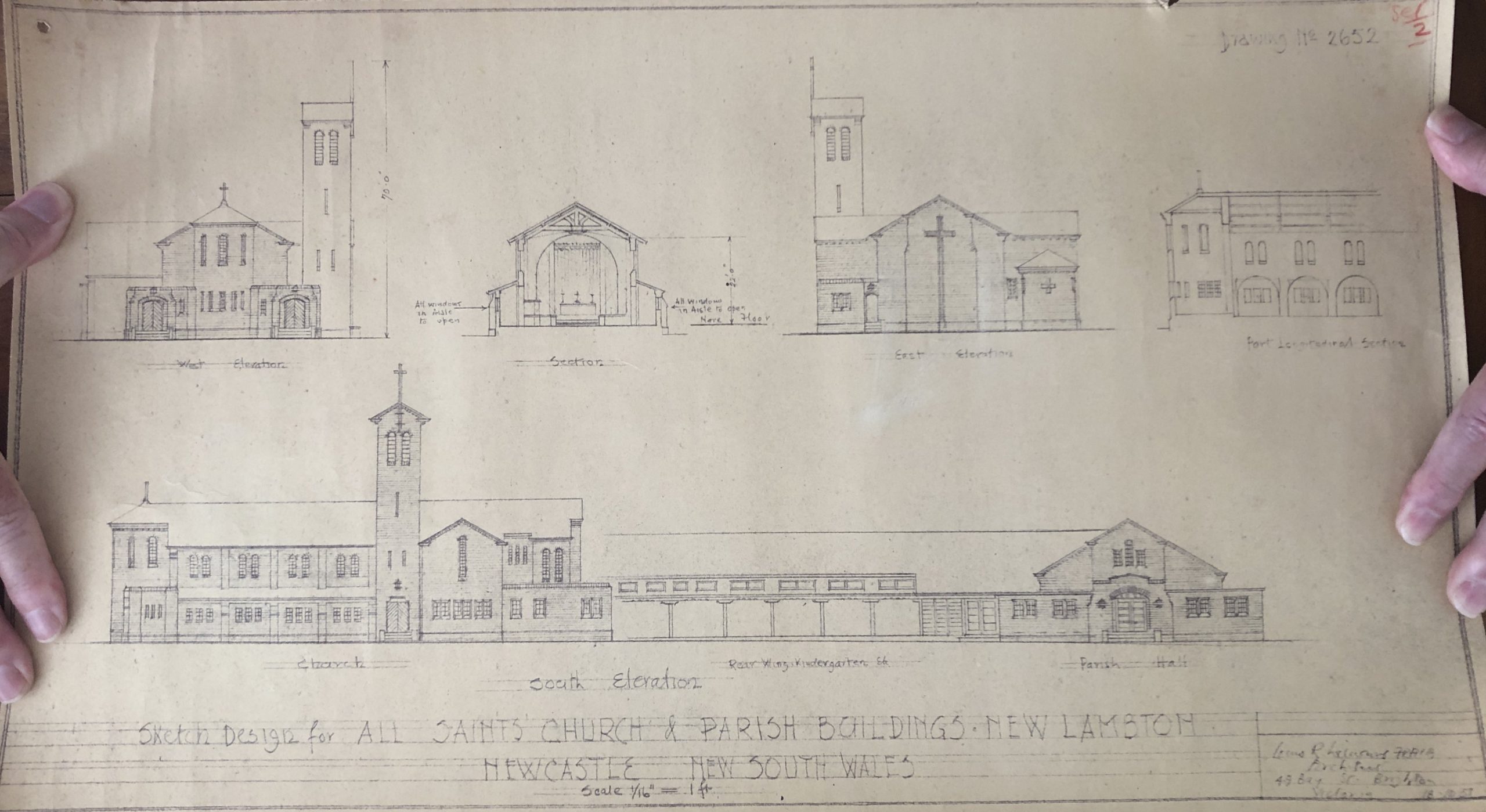
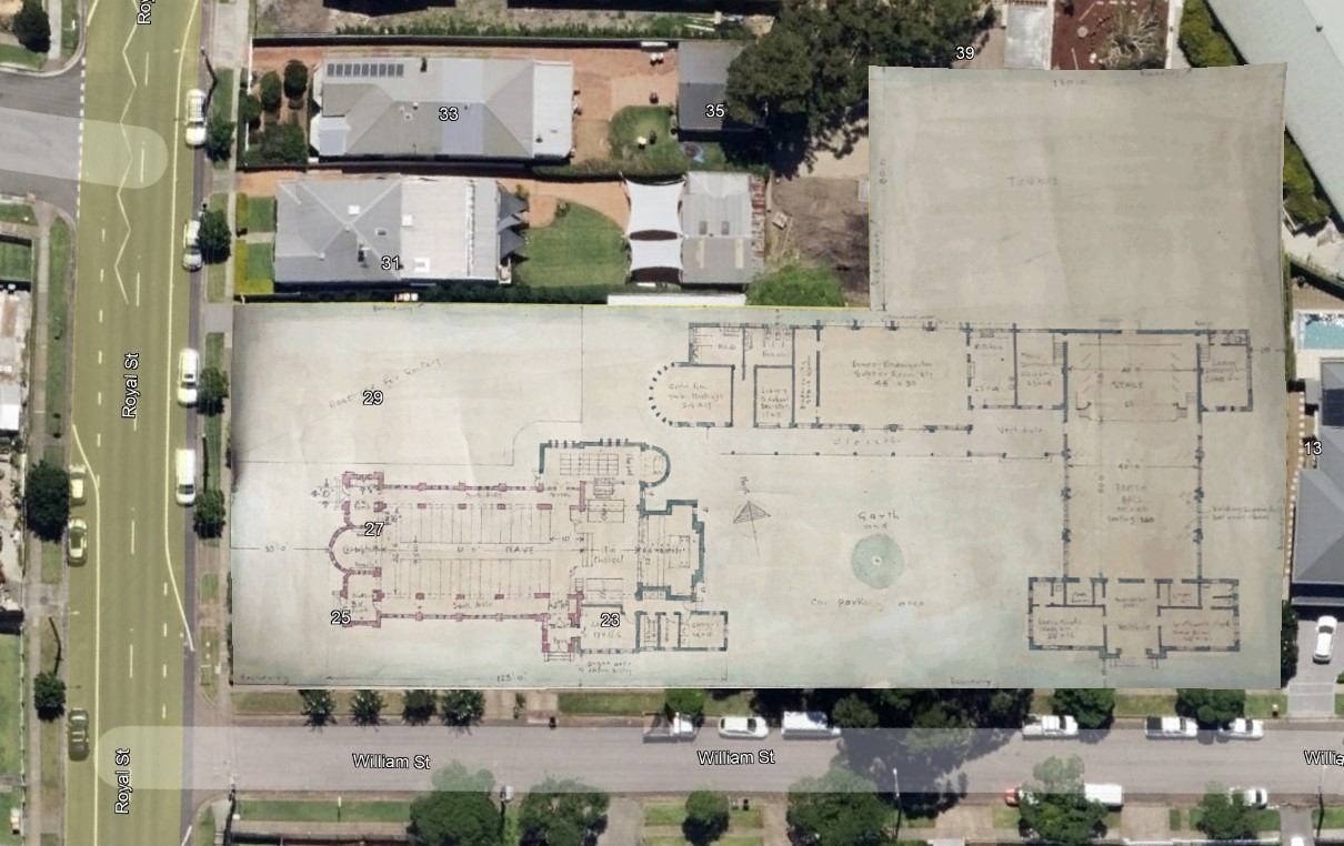
In the 1950s the parish of New Lambton made plans for a new church complex including a church, hall, offices, Sunday School rooms, and a rectory. In 1950 the diocese purchased an acre of land on the corner of Royal Street and William Street.
Purchase of land in 1950 for a church complex for All Saints. See Vol-Fol 1994-240 and 4081-173.
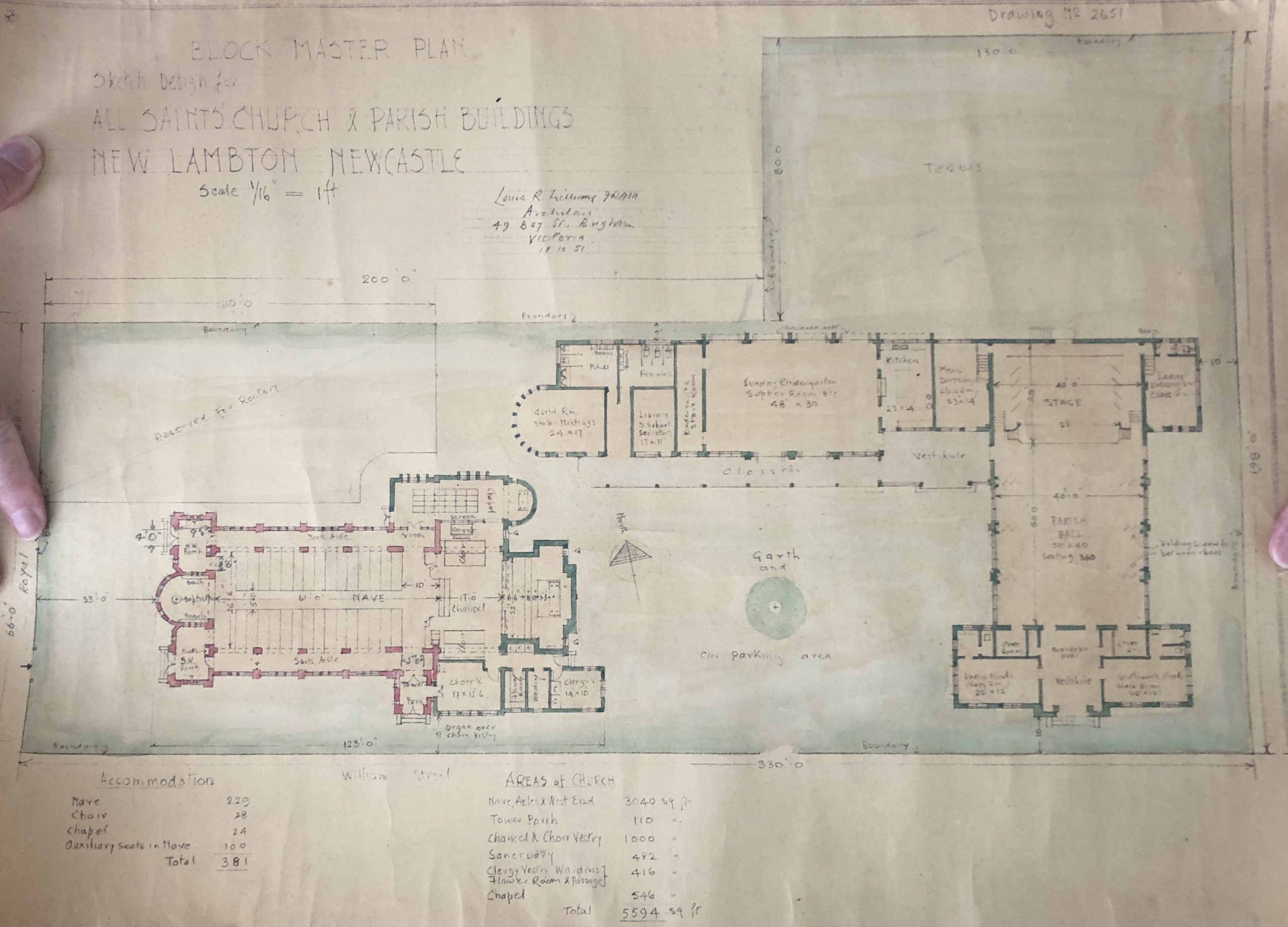
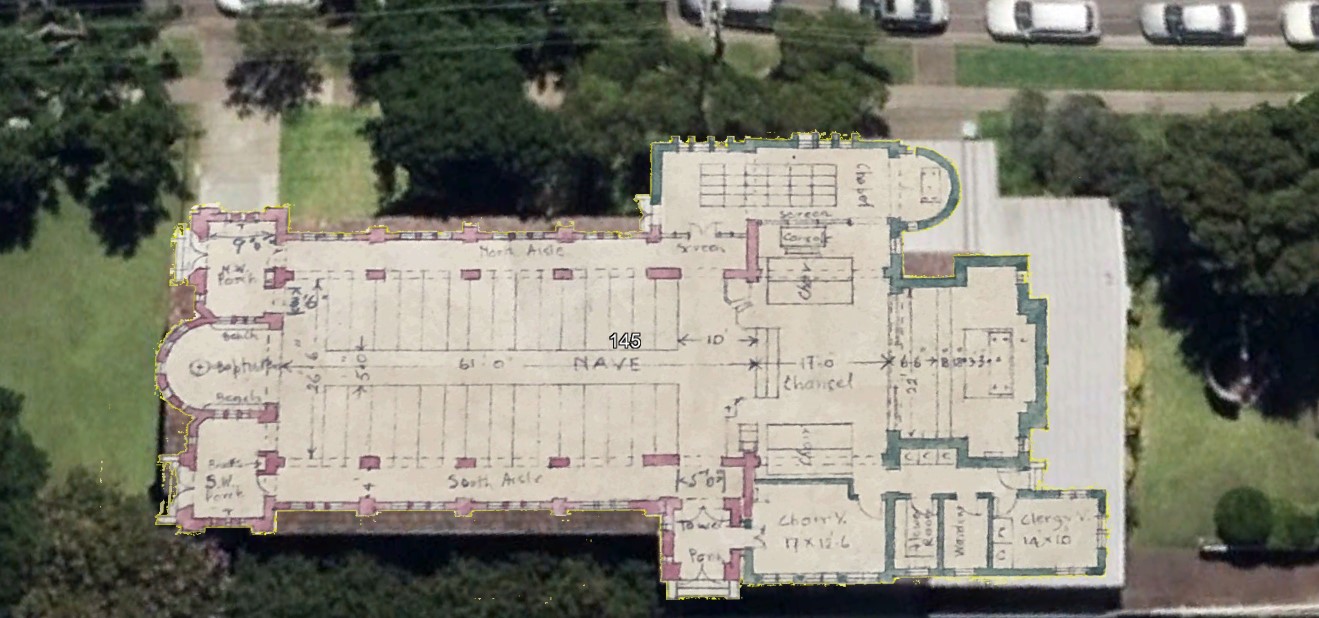
In 1951 plans were drawn up for two buildings on the land, with space leftover for a tennis court and a future rectory.
The 1951 church plans overlaid into Google Earth.
Overlaying the 1951 church plan over the building that was eventually constructed in Regent St, shows that the planned church was a very similar size and shape.
I have no information on why the plans for the Royal Place church was abandoned in favour of the 1959 building on Regent Street. Possibly cost was a factor. After the Regent St land was purchased in 1958, the Royal Place land was sold in 1959, some of it to the Catholic Diocese for expansion of St Therese’s Primary School.
"There has been some talk of building a place of worship in connection with the Church of England here ; but as that denomination is erecting a church at Old Lambton, and as the distance between that township and New Lambton is only about a mile, it is now supposed that one chapel will, for some time hence, at least, be sufficient for both places."
"The adherents of the Presbyterian Church hold their services in the mechanics' institute, while the Anglican Church use the same building for Sunday school purposes."
"The dedication of All Saints' Church of England at New Lambton by the Right Rev. Dr. R. Stephen, Bishop of Newcastle, on Saturday afternoon marked another advance step in the work of the Anglican Church In the Newcastle district. The service was conducted in the presence of a very large congregation. The new building has been erected at the corner of Cromwell and Oxford streets at a cost of £750. It is of the Gothic architecture, and is constructed of rusticated weatherboard. Its length is 60 feet by a width of 24 feet, the finish and furnishing being of a high class. The interest taken in the church is given evidence to by the large amount of voluntary labour in its construction, and in the making of the furniture, with the exception of the seats. Mr. Sowerby was the builder, and Mr. W. E. Lalley acted as clerk of works."
"The Anglican Parish of Lambton has grown so big during the last few years that it has been deemed advisable to divide it into two portions. When this can be conveniently arranged, All Saints will have a rector of its own, and will have to shoulder the financial responsibilities thus incurred."
"Special services will be held in the Church of England to-morrow, as advertised. New Lambton, which was part of the parish of Lambton, has been now formed into a separate district. "
"The parishioners of the new parish of All Saints' Church of England, New Lambton, held a social in the Institute Hall on Thursday night, when a welcome was extended to Rev. Mr. Linton, the newly-appointed rector."
Mr. Chapman said … " Many perhaps were pessimistic on breaking away from the Parish of St. Johns, Lambton, under the control of which all Saints' Church had been built. He, however, was optimistic in believing that as New Lambton was a growing suburb so would the cause of the Church of England grow to such an extent that additions would shortly be needed."
"At the New Lambton Mechanics' Institute on Saturday night, the parishioners of All Saints' Church, New Lambton, tendered a farewell social to Rev. Hugh Linton and Mrs. Linton."
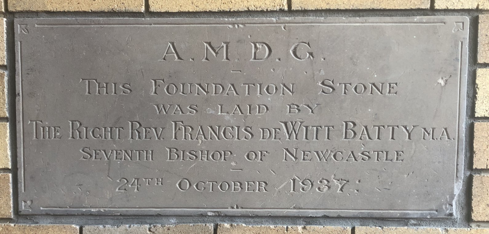
24 Oct 1937
Laying of the foundation stone of the new parish hall.
When Lambton Colliery began in 1863 a railway was built to haul coal to the harbour. Roads into Newcastle were in a very poor state and a trip to town was a major undertaking. An appealing alternative was to travel by train. For a few years the colliery allowed passengers in the guards’ van of their coal trains at a cost of 6 shillings per trip. Tiring of this arrangement, they doubled the price in 1866, then ceased the service in 1867.
In 1874 residents agitated for the return of a passenger train. Thomas Croudace, the manager of the Lambton colliery, gave permission for a trial run and on Saturday evening of 28 February 1874 more than 500 residents travelled from Lambton into Newcastle. Despite this success Croudace withdrew permission for subsequent services, leading to great confusion two Saturdays later when several hundred residents turned up to catch a train that never arrived.
With no co-operation from Lambton colliery, residents approached the Waratah colliery for permission to carry passengers on their rail line. The directors having granted the request, the first train ran on Monday 25 May 1874 for the public holiday celebrating Queen Victoria’s birthday. A regular service then commenced on 30 May 1874, operating on Saturdays only with pick-up and set-down at “Betty Bunn’s crossing”, where the Lambton-Waratah road crossed the railway.
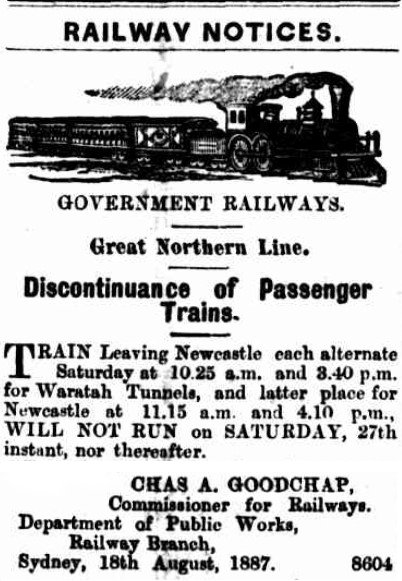
In August 1874 a fatal accident on the line put a halt to the passenger service. A sordid rumour began circulating that several storekeepers on the inquest jury had been unfairly critical of the rail authority’s safety procedures, with a view to having the train cancelled. Local traders opposed a service they saw taking shoppers and their money into the city and away from their own businesses. The passenger service eventually resumed in January 1875, but reduced to alternate Saturdays only. It operated for another 12 years, ceasing in 1887 when the tramline from Newcastle to Lambton opened.
Newcastle Morning Herald and Miners Advocate, 19 Aug 1887, advising discontinuance of passenger train services to Waratah Tunnels near Lambton.
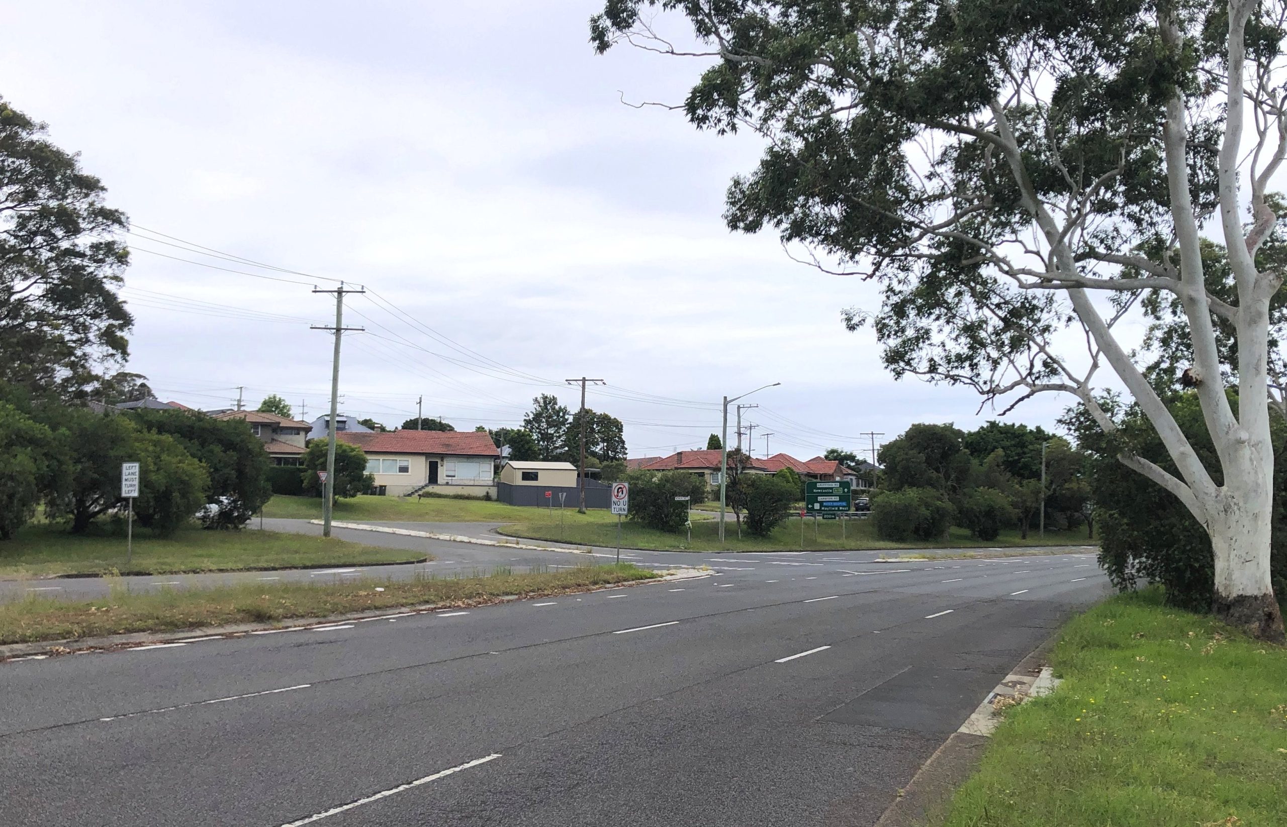
The location of “Betty Bunn’s Crossing”, at the intersection of Griffiths Rd and Acacia Ave, where the passenger train to Newcastle operated on the Waratah Tunnels rail line.
The article above was first published in the March 2024 edition of The Local.
Additional Information
Some of the content of this article was re-used from my November 2020 article “A Picnic Homecoming”, on the Lambton Public School outing to Toronto by train.
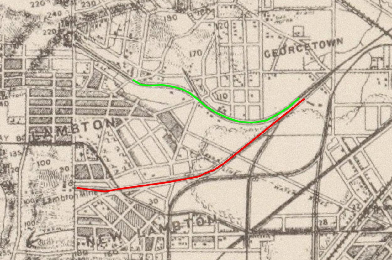
The colliery railway lines used for passenger services at Lambton: Lambton colliery (red), Waratah colliery (green). Parrott’s 1893 map, National Library of Australia.
"A very large public meeting was held at Stokers' Hall Lambton, on Thursday evening last, to consider the best steps to secure a Saturday night train, and also a daily train to and from Newcastle and Lambton. The manager of the Lambton pit had allowed the train to run once on Saturday night, and then withdrew it ; the object of the meeting was to devise a method of ensuring a train regularly. The Mavor of Lambton presided. It was ascertained that the Government were quite willing, and resolutions were passed, empowering the formation of a committee to wait upon the manager of the Waratah Coal Company, requesting him to allow passenger carriages to be placed on their line on the occasions above named."
"Great disappointment was felt at the non-arrival of the passenger train last Saturday evening. There were about 200 or 300 passengers waiting, who had to return to their homes annoyed. The blame is attributed to Mr. Croudace, for, I believe if he would consent to the train's running, the Government
would; and, the advantage the inhabitants would derive would be very great."
"The subcommittee appointed to conduct the application to the Waratah Coal Company, for a passenger train to be laid on, have received a reply from the directors, expressing their willingness to
grant the request … The sub-committee accordingly waited upon Mr. Higgs, the traffic manager, to
gain the required Government permission, and that gentleman has informed them that there were some arrangements pending respecting a train to be laid on by the Lambton Company, which had not yet been decided upon."
"I have been instructed to inform you that the directors of the Waratah Coal Company have no objection to the Government running, for the convenience of the inhabitants of the district, on Saturday nights and holidays passenger trains on the Waratah Coal Company's private line of railway,
from the junction with Great Northern Railway to the Company's new tunnel, at the same rate as it is
done on the Wallsend Coal Company's line, provided arrangements are made so as not to interfere with the Waratah Company's coal traffic, and that the Government construct at its own cost all sidings,
platforms, landing places, &c., which may be required for passenger traffic."
The following Monday, being a public holiday for Queen Victoria's birthday, "arrangements were made for the train to leave Bunn's crossing on Monday, 25th May at half-past 10 o'clock a.m."
First passenger train on the Waratah Company railway.
"The Railway Auditors laid on a train from Bunn's Crossing, on the Waratah Company's line, on Queen's Birthday, which was moderately patronised."
In the same week that passenger trains start running to Lambton on the Waratah Company line, promises are being made to run passenger trains on the Lambton colliery line … "The following arrangement was made, between Mr. Croudace, on behalf of the Lambton Company, and the Minister,
viz., that [Government] trains should be run ... that the Company give their line free and keep it clear of their own traffic ... The Government to take all other responsibility … this arrangement to come in force immediately after the holidays."
In spite of this arrangement being made, nothing came of it.
"Although the Minister for Works promised that a passenger train should be run to this town on the first Saturday after the holidays, no communication whatever has been received by the Traffic Manager on the subject. The arrangement made between the Minister for Works and Mr. Croudace was that four trains should be run, commencing on the first Saturday after Queen's Birthday."
"On Saturday, the first evening train for passengers ran from the Waratah Co.'s Tunnels to Newcastle, for the accommodation of a large population in that neighbourhood. The number of passengers by whom it was availed of, amply testified the necessity for the convenience. We take it for granted that the train will be continued, as otherwise the people of Grovestown and Lambton would have to give
up all idea of getting into Newcastle during the winter evenings, either by way of the Broad Meadow or Waratah, the former being a sheet of water, and the latter a perfect slough of mud."
Fatal accident on the Waratah Company railway, when the Saturday evening passenger train strikes Andrew Tunney, who while drunk was riding his horse along the railway.
After the death of Andrew Tunney on the railway line, the passenger service to Lambton is halted. A conspiracy theory arises that storekeepers on the inquest jury had a vested interest in stopping the passenger service in order to keep business in the town.
This year marks 120 years since George Henry Dawkins captured a remarkable snapshot of our locality in 1904. Dawkins was born in Lambton around 1874. His interest in photography is first noted in 1900 when he demonstrated lantern slide making to the recently formed but short-lived Newcastle Amateur Camera Club. A few years later he was instrumental in the formation of a new camera club and served as a committee member for many years.
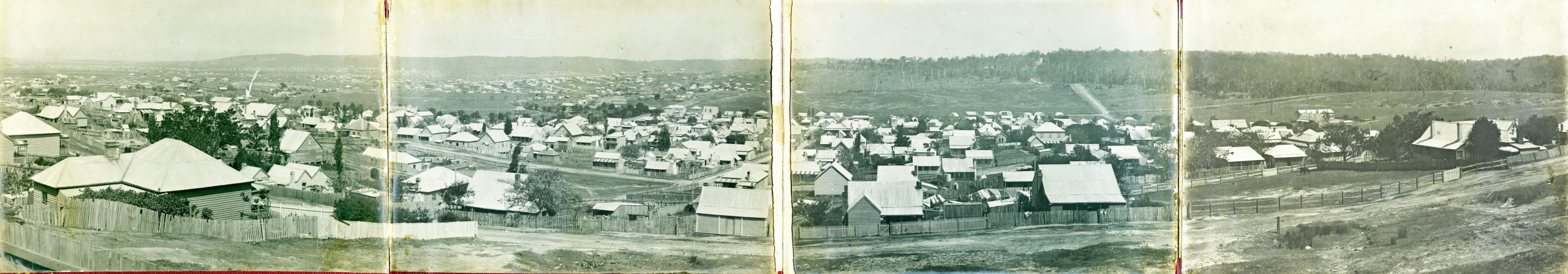
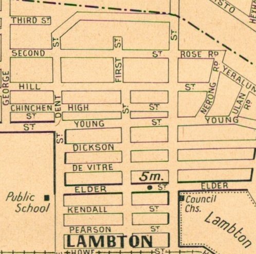
In 1904 Dawkins purchased a block of land on the heights above Lambton. From that property on the west side of First St (later renamed to Noble St) he photographed a four-frame panorama looking southwards. He then mounted the prints on foldout panels with an ornate burgundy coloured front cover with the title “A Peep at Old and New Lambton, NSW, from Lambton Heights.”
The panorama is striking in the detail it contains. We can observe prominent landmarks that remain to this day including the park rotunda, council building (now the library), Mechanics’ Institute building, and the stone church in Dickson St.
The photo also highlights how much has changed. Many of the houses in 1904 are basic wooden structures. While the Lambton mine pithead is hidden behind a hill, the colliery rail line and bridges can be seen running over Hobart Rd. In panels 3 and 4, we see large swathes of open land south of Howe St and wooded land on the hill, yet to be developed as it was mining company land.
While Dawkins’ paying job was as a printer, he also volunteered with many local organisations such as the Mechanics’ Institute, Bowling club, and the Wallsend hospital board. In 1907 he contributed photos to a Newcastle Tourist Guide, and during World War 1 he offered to take photos free of charge, of any men in Lambton enlisting as soldiers. George Dawkins died in Lambton in 1922 aged just 48, leaving us the legacy of a wonderfully fascinating panoramic peep into our past.
The article above was first published in the February 2024 edition of The Local.
Additional Information
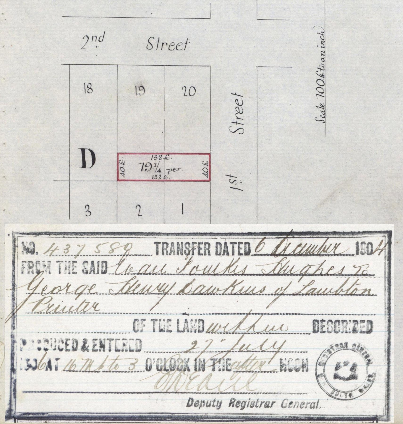
Purchase of land in 1st Street (Noble St) by George Henry Dawkins, printer, in December 1904. The panorama over Lambton was photographed from this property. Vol-Fol 890-235.
1939 Gregory’s map showing location of First Street (now Noble St) in Lambton.
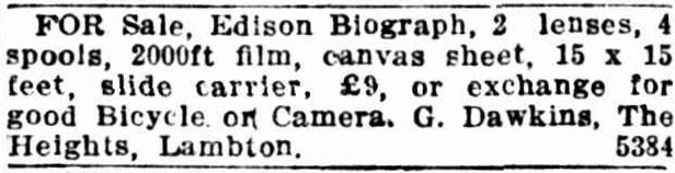
Photographic items for sale from George Dawkins. Newcastle Morning Herald and Miners’ Advocate, 15 June 1918.
The 1907 Tourist Guide
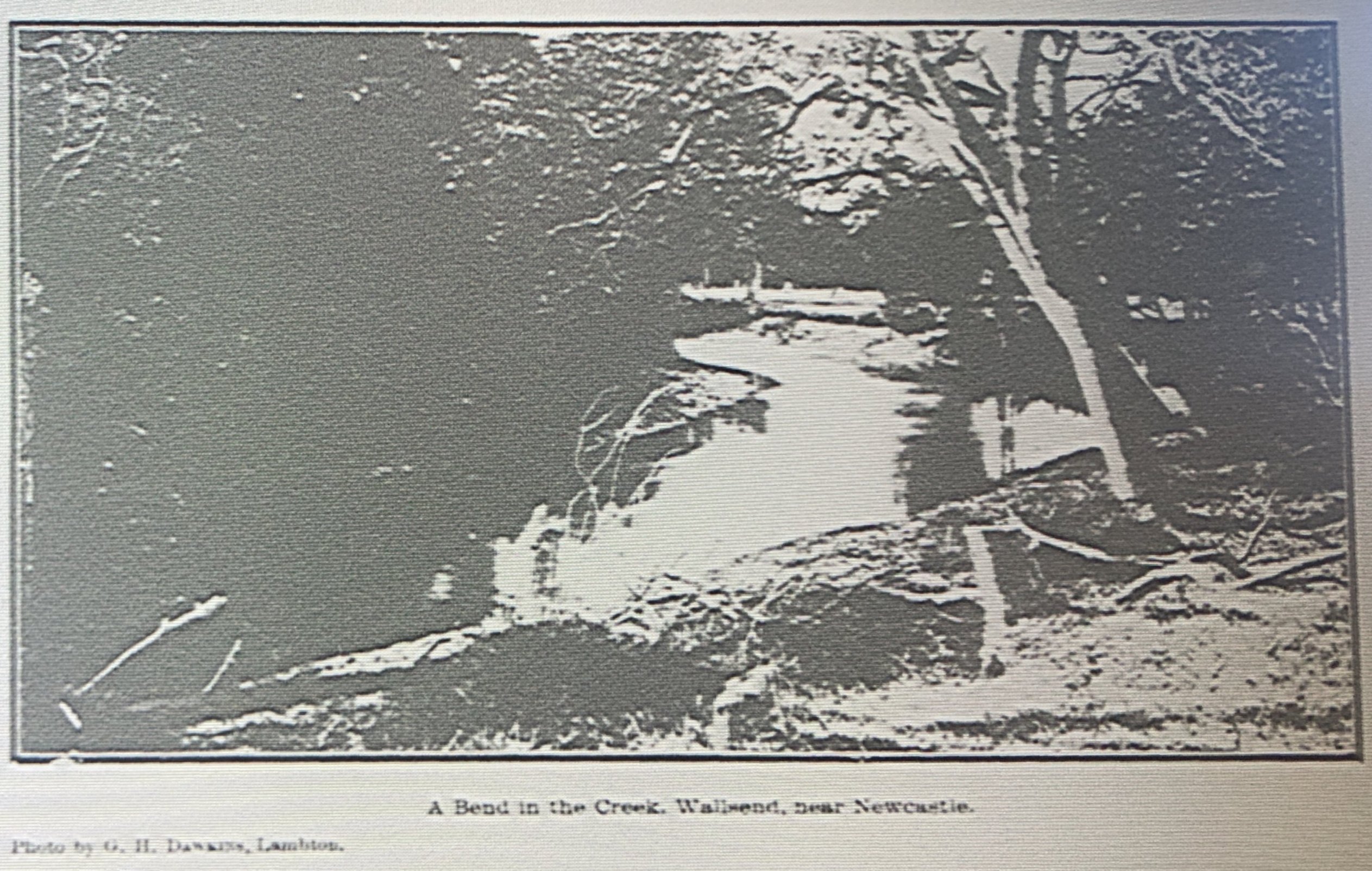
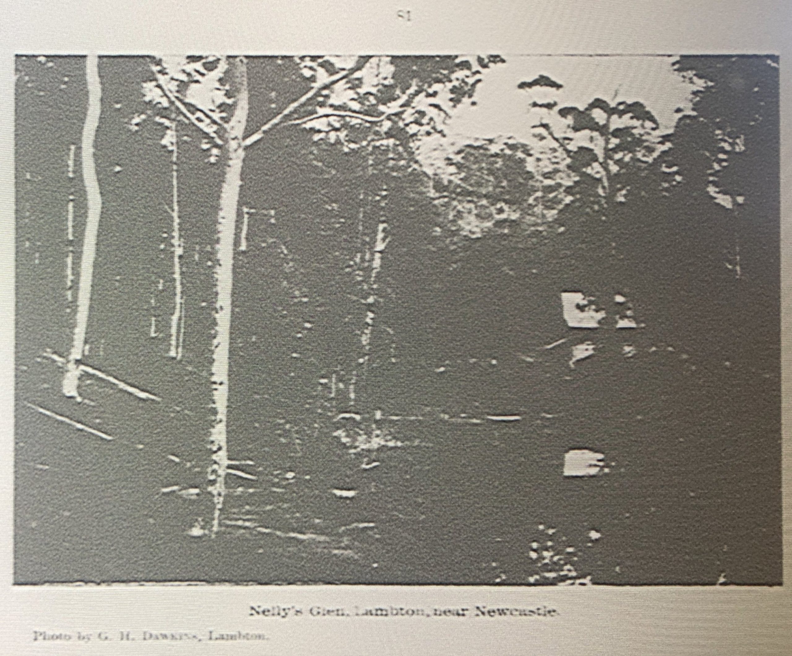
Dawkins contributed some photographs to a 1907 “Tourist’s Guide to Newcastle”. The National Library of Australia has a copy of this publication on microfiche (Bib ID 3542657), which I viewed during a visit to the Library in April 2024. Unfortunately the quality of the scanning/reproduction is poor and the photographs appear as little more than high contrast splodges of black and white. For what it’s worth, here are the photographs that Dawkins contributed. One minor note of interest is that the photograph of Nelly’s Glen on page 81 enabled me to identifier the creator of the image in the Newcastle University Living Histories site, which previously unattributed.
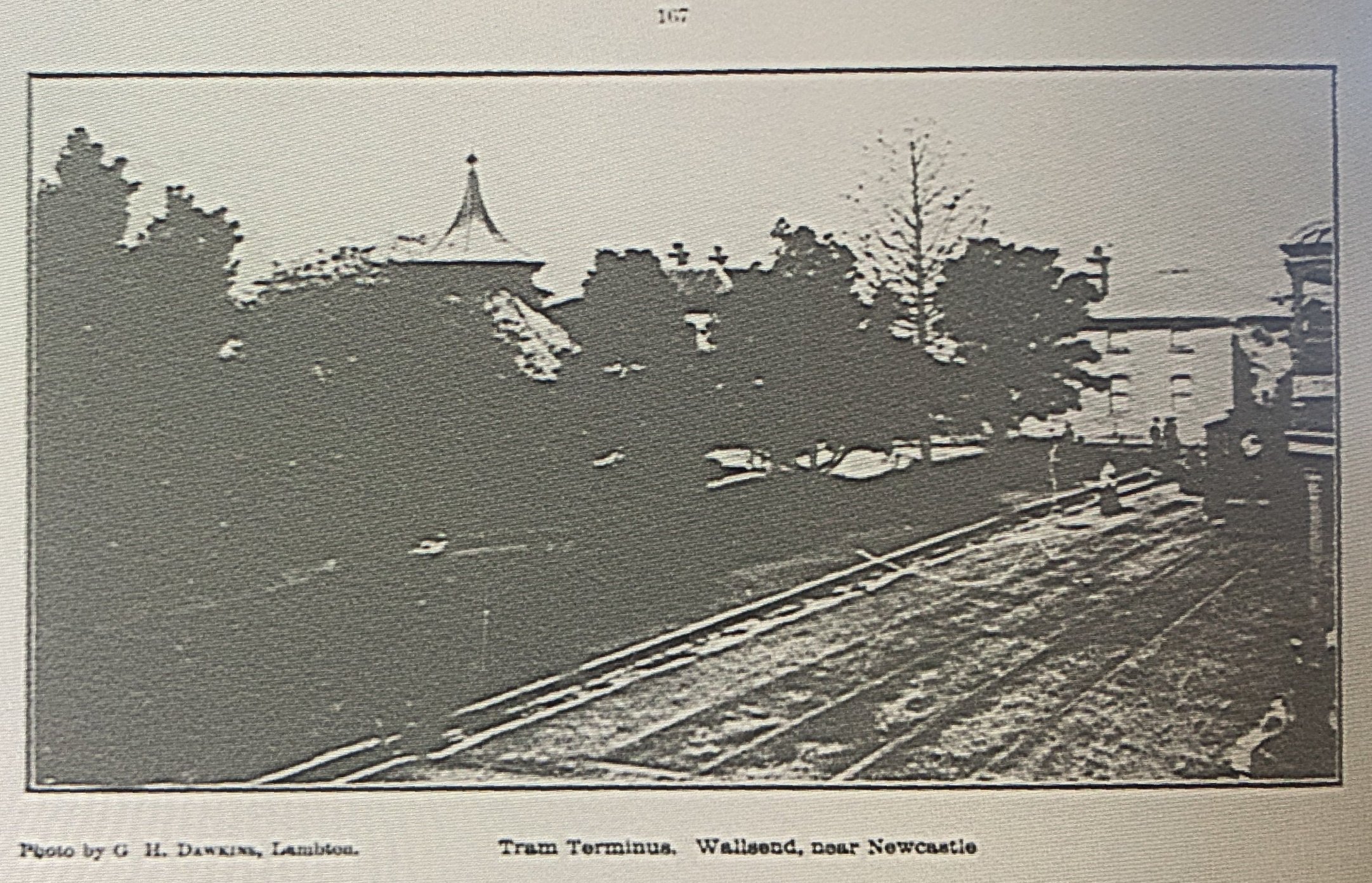
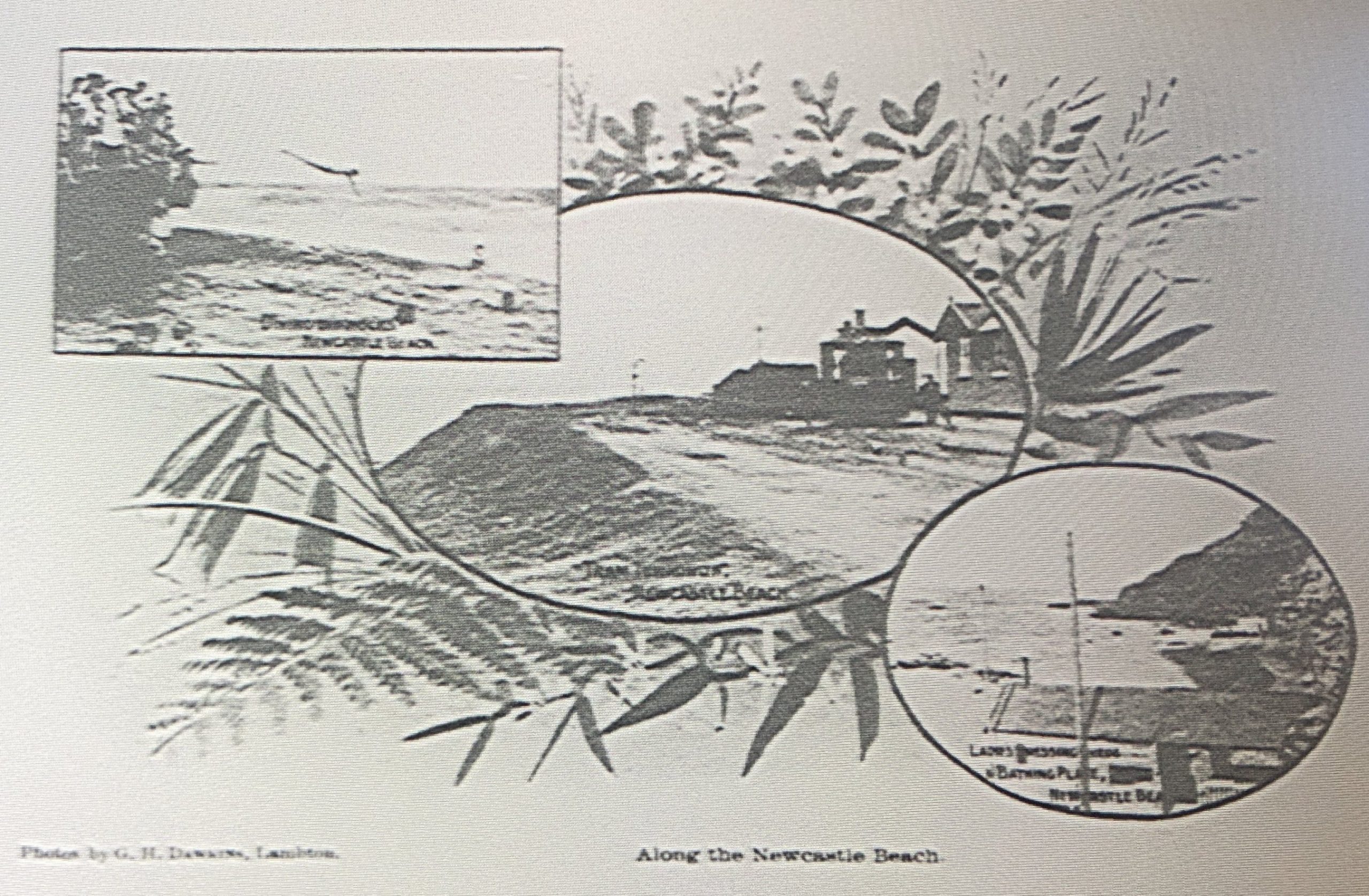
A Bend in the Creek. Wallsend, near Newcastle. (Page 75)Nelly’s Glen, Lambton, near Newcastle. (Page 81)Tram Terminus, Wallsend, near Newcastle. (Page 167)Along the Newcastle Beach. 1. Men’s Dressing Sheds. 2. Untitled. 3. Shelter Shed. 4. Shelter Shed. (Page 177)Along the Newcastle Beach. 1. ?. 2. Tram Terminus. 3. Ladies Dressing Shed & Bathing Place. (Page 181)
Page
PREFACE
5
NEWCASTLE
9
The Beaches
29
The Reserves
42
The Climate
48
Health of Newcastle and District
49
Newcastle from Without
49
Industries
53
Coal Mining
53
The Dyke
58
Other Industries
59
Churches
59
Literary, Scientific and Educational Institutions
63
Technical College
67
Schools
67
Municipal
70
Commercial
74
Military
74
Theatres etc
78
Musical and Kindred Societies
79
Debating Societies
79
Sports and Amusements
82
The Turf
90
Agricultural, H & I Association
92
Charitable Institutions
96
Public Buildings
100
Newspaper
105
Pleasant Bush Drives and Picnic Places
105
Accommodation for Visitors
112
Discovery of Newcastle
112
LAKE MACQUARIE
117
Toronto
117
Belmont
120
Swansea
120
Spiers’ [sic] Point
120
Warner’s Bay
120
Cockle Creek
121
PORT STEPHENS
121
Nelson’s Bay
121
Salt Ash
121
Anna Bay
121
Tea Gardens
121
Sawyer’s Point
121
Bulladelah [sic]
125
THE MAITLANDS
128
West Maitland
128
East Maitland
133
Maitland Coalfields
133
MORPETH
133
RAYMOND TERRACE
140
PATERSON
140
DUNGOG
144
STEAMER, COACH AND FERRY INFORMATION
151
TRAMWAY AND RAILWAY INFORMATION
165
RAILWAY TIMETABLES
168-178
OFFICERS OF NEWCASTLE & N.D. TOURIST ASSOCIATION
182
General Index to the 1907 Tourist Guide
Page
Newcastle from Railway Station
7
Holiday Time on Newcastle Beach
11
Tennis Court and Bowling Green
15
The Two “Redheads”
19
Nobby’s from Fort Scratchley
23
Surf Bathing
27
Newcastle Beach
31
Newcastle Beach from Tram Terminus
33
Shelter Sheds
37
James’ Retreat
41
The Rotunda
45
Entrance Gates, Upper Reserve
47
Lower Reserve
51
A Typical Newcastle Colliery
53
Shephard’s [sic] Hill
53
The Lagoon
57
Loading Coal at the Dyke
61
Ships Discharging Ballast
65
Technical College
67
Shipping at the Dyke
69
King’s Wharf
71
A Forest of Masts
73
A Bend in the Creek, Wallsend Creek
75
Newcastle Harbour
77
Nelly’s Glen, Lambton
81
The Tunnel, Merewether Beach
83
E. & A. Coy.’s Smelting Works
85
Newcastle from Upper Reserve
89
Soldiers’ Baths and Nobby’s
91
View of Newcastle showing Entrance to Harbour
93
Post Office
95
Newcastle Hospital
96
Newcastle from the Beach
99
Post Office
100
The Bogey Hole
103
Upper Reaches, Cockle Creek
107
Spier’s [sic] Point
111
Toronto
115
Newcastle Harbour
116
Belmont
119
Port Stephens from Inner Light
123
Salt Ash
127
Port Stephens, looking towards Middle Island
129
High Street, West Maitland
131
Pitnacree Bridge, East Maitland
135
Morpeth
139
Paterson
143
Movable Cranes, Inner Basin, Newcastle
147
Glimpses around Dungog
149
Toronto
155
Warner’s Bay
159
Newcastle School of Arts
163
Tram Terminus, Wallsend
167
Lake Macquarie
171
Along the Newcastle Beach
177
Along the Newcastle Beach
181
Index to Views (photographs) in the 1907 Tourist Guide
"A meeting of amateur photographers was held at Kettley's rooms, Hunter-street West, last night, when it was decided to form the Newcastle Amateur Camera Club."
"Newcastle Amateur Camera Club held their monthly meeting and had for their subject
Flashlight Photography. The members met at Lambton at 7.45 p.m., and proceeded to Lambton Colliery, where they were met by Mr. Noble, the underground manager, and his staff, who zealously looked after the
comfort of the visitors, and explained every thing of interest."
"... the guide to Newcastle and its neighbourhood has been issued by the Newcastle and District Tourist Association. The work, which comprises 180 pages, 8½, inches by 5½ inches, is copiously illustrated ... The photo-engravings are principally from negatives taken by Mr. Charleston, of Hunter-street, Mr. G. H. Dawkins, of Lambton, ..."
The half-yearly competition and exhibition of pictures in connection with the Newcastle and District Photographic Society - George Dawkins awarded second place in "Best enlargement" section.
"A concert, in aid of the Lambton Public School fund was held in the Coronation Hall … The coloured lights
for stage purposes was under the direction of Mr. G. H. Dawkins …"
"A meeting for the purpose of forming a branch of the Y.M.C.A. Snapshot From Home League was held at Mr. A. J. Plumridge's rooms on Thursday evening. Mr. G. Dawkins presided. The object of the league is to provide snapshot photographs of the homes and families of soldiers who have gone away into service, and give copies of these to the relatives for forwarding to soldiers at the front. It was decided to form a branch. Mr. G. Dawkins was appointed president."
"A meeting was held in Lambton council chambers to devise ways and means to erect a suitable memorial to those who had given their services in fighting for their country ... Mr. George Dawkins, a member of the Camera Club, had agreed to take photos, free of charge of any soldier enlisting …"
"Mr. George Dawkins died at his residence, First-street, on Saturday, after a lengthy illness. He was in
his 49th year, and was born in Lambton, where he resided the whole of his life. He was a printer by occupation."
When you’re in a time of technological change, it’s hard to know which innovations will last, and which will fade away. That’s a problem New Lambton council faced 100 years ago, when they moved to mechanised transport.
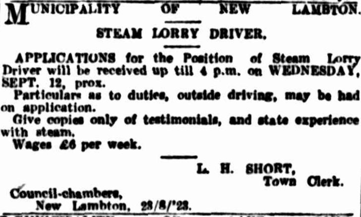
In August 1923 the council decided to sell their horses and drays and purchase a steam powered “Super Sentinel” lorry. Manufactured in Shrewsbury, England, the lorry was sent by ship to Sydney for final assembly. The council advertised for a driver, and with the economy still suffering a high rate of post-war unemployment, received 96 applications for the position.
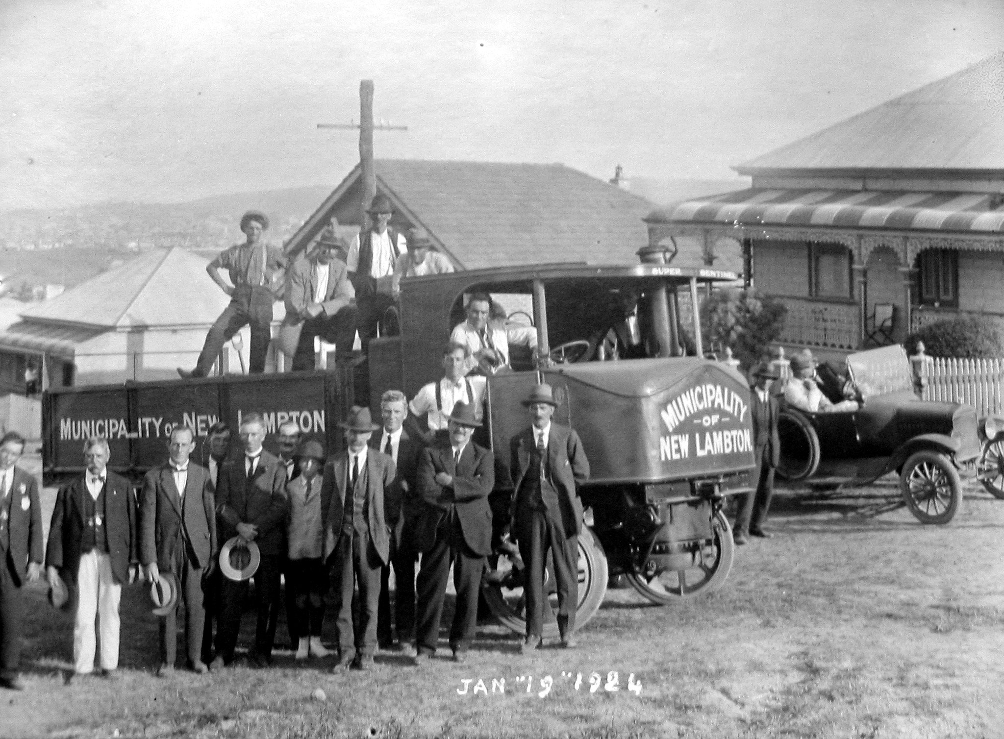
With the truck’s arrival early in the new year, council arranged a public demonstration on 19 January 1924. The Newcastle Morning Herald reported “The Super Sentinel steam lorry purchased by the council for £1400 was given a very successful trial on Saturday afternoon, in the presence of the aldermen of the municipality and several visiting aldermen. The machine was driven by Mr. C. J. Robinson, and the various steep grades were easily negotiated with a 6-ton load of gravel.”
Despite the glowing appraisal of this new technology, reality did not measure up to expectation. The following year breakdowns regularly kept the lorry out of action. At a fiery council meeting in October 1925, some blamed the driver for operating the truck inappropriately. With continuing breakdowns, a motion was tabled in March 1926 to dispose of the lorry. The motion was defeated, but soon afterwards council decided to supplement the troubled steam machine by purchasing a petrol lorry, the first of many more to come. The “Super Sentinel” continued to be used until the amalgamation of suburban councils into Greater Newcastle Council in 1938. In June 1941 Newcastle council briefly brought the steam lorry back into service to assist the effort to conserve petrol supplies during the war. When war-time rationing ended, the age of steam powered road transport was soon over, and petrol and diesel power has dominated to this day.
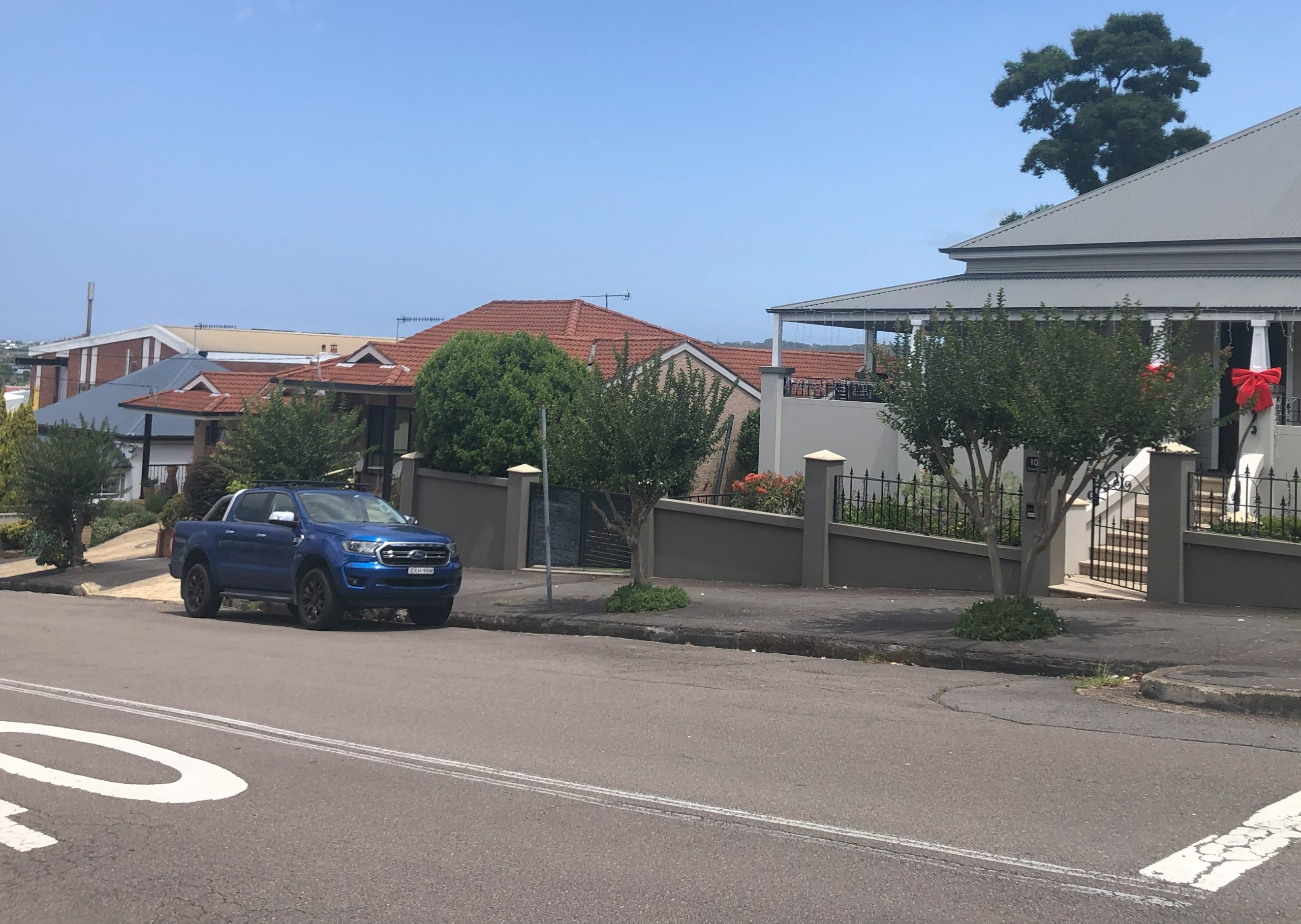
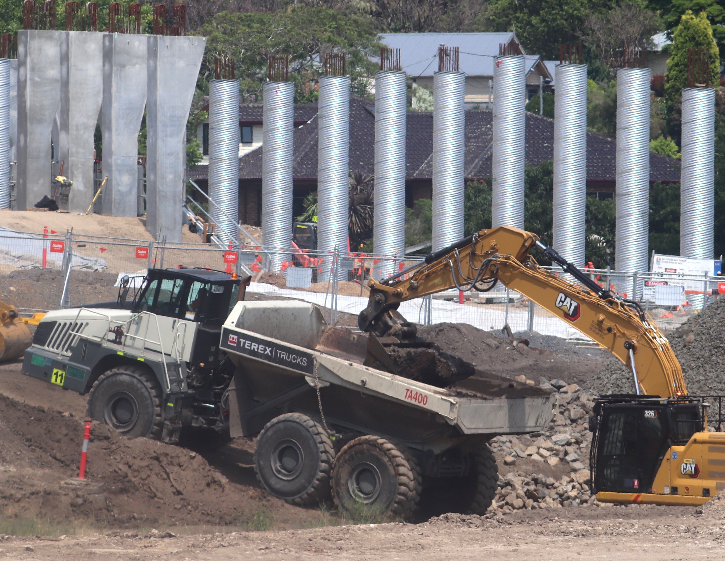
The “Super Sentinel” steam lorry with a capacity of 6 tons, on Russell Road New Lambton, 19 January 1924.The same location on Russell Road in 2023. Note that the bullnose verandah roof of the house on the right has been replaced at some time.A Terex TA400 diesel powered truck with a capacity of 38 tons, at the Rankin Park to Jesmond bypass construction site.
The article above was first published in the January 2024 edition of The Local.
Additional Information
Advertisement for driver for New Lambton’s steam lorry. Sydney Morning Herald, 25 August 1923.
In the article I wrote that the Super Sentinel was “manufactured in Shrewsbury, England” which seems to contradict a 17 October 1923 report on the imminent arrival of the “steam lorry which was ordered by the New Lambton Council from the makers in Scotland.” The apparent discrepancy is explained by the fact that the steam waggons were originally manufactured by the Allen and MacLellan company in Glasgow, Scotland, but with growing demand for their vehicles, in 1915 they opened a new factory in Shrewsbury, England, dedicated to the manufacture of steam powered vehicles.
Greg and Silvia Ray’s Photo Time Tunnel website has a couple of photographs of the Sentinel steam lorry from 1941, when Newcastle Council brought it back into service to assist with the conservation of petrol supplies during World War 2.
After many years of relying on contractors for the carting of material, New Lambton council "decided to purchase a horse and tip dray for general carting, and the Mayor, along with Alderman Mitchell and the council clerk, were appointed a sub-committee to purchase material for the erection of stables and sheds in the yard of the council chambers."
New Lambton Council - "At a special meeting held during the week, to consider the transport, it was decided to purchase a Sentinel steam lorry at cost of £1160, and the existing plant (horses and drays) be sold, and, further, that applications be called for driver under conditions fixed at a wage of £6 per week."
New Lambton Council meeting - "M. Whylie, asking council's opinion re applications to be called for driver for proposed Sentinel steam lorry. As driver of the present plant, he claimed preference to the position, if proficient, and able to pass necessary test. This he would be prepared to do at his own expense."
"Ninety-six applications were received for the position of driver for the steam lorry ... it was decided to hold a special meeting to finalise the position of driver on Monday night week."
"Alderman Cameron moved that as the motion in connection with the appointment of driver for steam lorry was for consideration of local applicants firstly, and seeing that Mr. Scowcroft was not a resident, the resolution passed at the special meeting of the council held on 24th September appointing him to the position, be rescinded, and that a fresh ballot be taken at the next ordinary meeting of the council. He contended that the method adopted was not fair, as it allowed a minority to exclude any applicant. The
motion was carried."
"The Super Sentinel steam lorry, which was ordered by the New Lambton Council from the makers in Scotland, at a cost of £140, is expected to arrive next month. The machine is fitted with a three way tipping waggon, allowing of the material to be deposited on either side or from the back. It will have a capacity of from five to six tons. The steam lorry will replace the council's present plant of three horses and three
drays, and it is anticipated will effect a material saving in time and expense."
"New Lambton Council has accepted a tender of £190 for the erection of a garage to house the council's Sentinel steam waggon. The Mayor (Alderman Brown) will supervise the erection of the building."
"W. Adams and Company, Limited, advised New Lambton Council that the Sentinel steam waggon would be delivered in the second week in January. The council decided that the driver be sent to Sydney for instruction on the waggon, and that the test of the machine be made from Greta-road to Evescourt-road, via Russell-road, then up Rugby-road to Brett-street and Carrington parade."
The Sentinel steam lorry which was ordered by New Lambton Council some time ago arrived at Sydney by the steamer Tairora on January 3, and it is being assembled. It is expected that the lorry will be handed over to the council on Saturday, January 19, when it will undergo a test, to which representatives of the various Newcastle district councils are being invited.
"We are advised by the local house of Wm. Adams and Co., Ltd., that the first super-Sentinel model to arrive in Newcastle will be delivered to the New Lambton Council on Saturday afternoon next, 19th, at 3 p.m., when official trials by the council will take place. After the official trials, the waggon will be on view at the park, where the fireman's gala is being held."
"The super Sentinel steam lorry purchased by the council for £1400 was given a very successful trial on Saturday afternoon, in the presence of the aldermen of the municipality and several visiting aldermen. The machine was driven by Mr. C. J. Robinson, and the various steep grades were easily negotiated with a steam pressure of 190lb, the machine being gauged to 230lb, and carried a 6 ton load of gravel. On reaching the highest point an exhibition of the machine's three-way trip was given. It ran very smoothly, silently on route of trial, and was driven to the sports, where the general criticism passed was more rates'." - Newcastle Morning Herald
" 'Jump on the waggon, boys, and we'll all have a ride.' This was the Mayor's injunction on Saturday to the aldermen and visitors who assembled to witness the trial of the new Super-Sentinel waggon purchased by
New Lambton Council. The test was a severe one, and fully demonstrated the capabilities of the 'super.' With a load of six tons of gravel (irrespective of the human contingent) the Sentinel climbed Russell road
and then backed down, demonstrating the brake control. Then it went along Regent street and up to Evescourt road, a test good enough for anything in New Lambton. Afterwards it proceeded to Rugby-road,
where the unloading facilities of the waggon were demonstrated. Either side may be tilted, also the back. All present were satisfied with the demonstration." - The Newcastle Sun
"New Lambton Council possesses a motor lorry. It is used for carrying road-making material about the
municipality; but it is out of action at present. This was tho subject of a long, and at times angry, discussion at last night's council meeting. The council must try to prevent the constant stoppages of the lorry for repairs, because these were a drain on the funds."
"At the beginning of 1924 the old system of carting by horse and dray was changed and mechanical transport by a steam waggon substituted. This has proved an economical method of traction, hauling quarry metal over a distance of three miles, and enabling a road to be completed at less cost than the metal could be purchased either at Broadmeadow or at Adamstown. Carrying out the same work under old conditions would have been prohibitive."
"A report on the lorry was placed before the council, and created considerable discussion. Alderman Brown gave a verbal report of his interview with Mr. Parsons, which substantiated the written document. It referred to several matters of repairs, which could have been done by the driver."
"The detailed report of an engineer on the lorry was then considered. The Mayor reported the synopsis of the whole question, and the resignation of the driver, with its subsequent withdrawal. The driver was given an opportunity of making a statement. The assistant driver was also given the opportunity of stating his case, in which he said that both drivers had been made scapegoats, which was an unfair proposition. No action was taken."
"New Lambton Council some time ago purchased a steam lorry for traction work on the streets. Great things were expected, but expectations have not been fulfilled. At last night’s meeting of the council Alderman Auckett tabled a motion to dispose of the lorry by tender.” Alderman Auckett: "The lorry has not been satisfactory to any one. It has cost a considerable sum for repairs, and as it has not given satisfaction we should get rid of it."
"In a report submitted to the council, the engineer (Mr. Williams) recommended that a light type of motor lorry, from two to two and a half tons, be purchased for street and gravel work, and that the present steam lorry be retained for a further period. During the winter months, the engineer stated, to carry on satisfactorily, the council would be compelled either to employ drays continually or purchase some lighter vehicle to carry gravel to places where the heavy steam lorry could not go."
"Why is the steam lorry not giving satisfactory work, and what is the cause? These questions were put to the
New Lambton engineer, Mr. Williams, at the local council meeting last night. In reply, the engineer said that the driver was the cause. He said he was old, and his nerves were not good, and he could not do the work. He recommended getting another driver to do the work for a month. The recommendation was adopted."
"The council has added to its road making plant by the purchase of a 2½ ton motor lorry. The council possesses a 6-ton steam lorry. The lighter machine has been acquired for maintenance work, and it will do away entirely with horses and drays."
New Lambton council "has the most modern and comprehensive plant of any municipal council in the district. The plant comprises four motor-lorries, a steam lorry, two steam rollers, a footpath roller, a road grader, four concrete mixers, and scores of subsidiary roadmaking tools."
"An old steam waggon which has been lying idle in Corlette-street depot for several years is to be brought back into service again by Greater Newcastle Council to haul metal and gravel. This is one step in the council's programme to assist the Government in conserving supplies of petrol."
“There are at present no streets that can lay any claim to the name – they are simply cart tracks and foot tracks and when one of these becomes too bad to travel on owners of vehicles simply go and pick out another.”
Newcastle Morning Herald and Miners’ Advocate, 29 March 1886.
Such was the state of roads in New Lambton in 1886 some 18 years after the town began. The need to improve the streets was a major impetus for formation of New Lambton council and was extensively discussed in their very first general meeting in March 1889. To turn rutted dirt tracks to solid roadways the council needed gravel, and as they owned no land, they sought assistance from the local collieries.
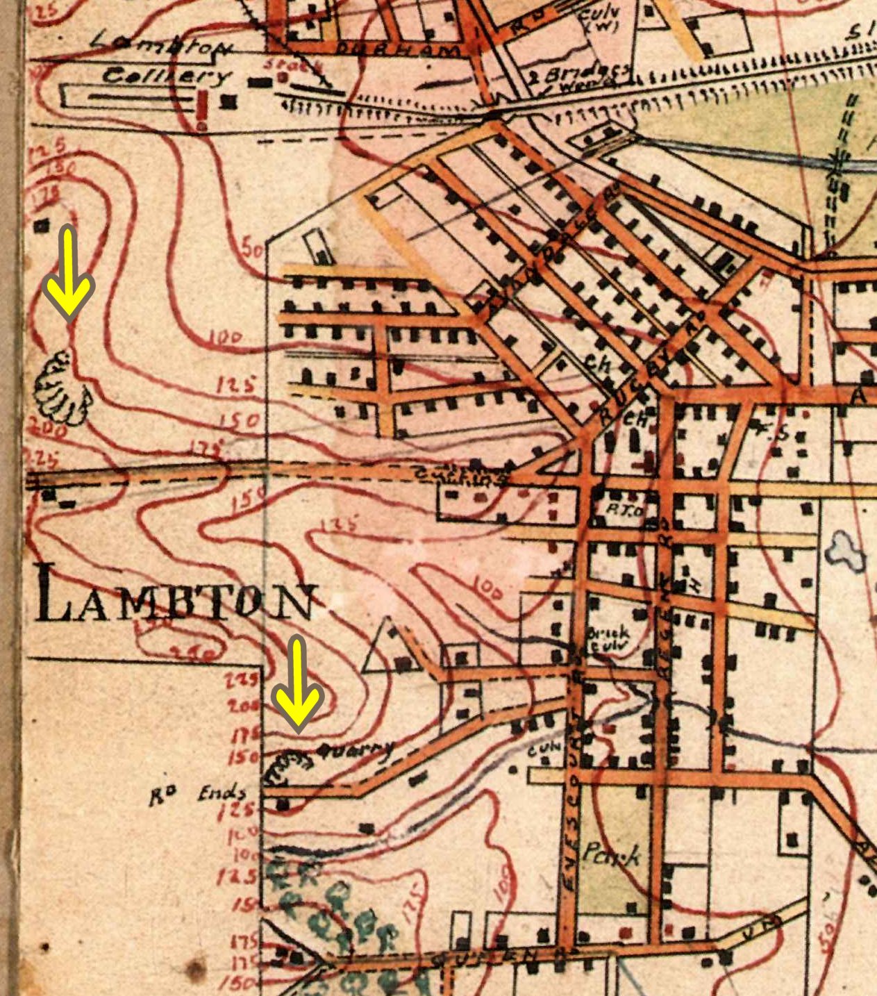
For the roads in the southern half of the town, the New Lambton Land and Coal Company allowed the council to obtain material from their quarry at the top of Addison Road. To transport the gravel down the hill, in 1890 the council constructed a 400-yard tramway down to Evescourt Road.
For the roads in the northern half of town, Thomas Croudace, manager of Lambton colliery and mayor of New Lambton, agreed in 1891 for the council to use the company’s quarry in the pit paddock hillside. As before, a tramway was constructed to get material down to the streets. Unsurprisingly, the combination of skips, rails, and a steep incline proved irresistible to local lads. In October 1891 a 13-year-old boy was severely injured when the skip he was riding down the hill left the rails.
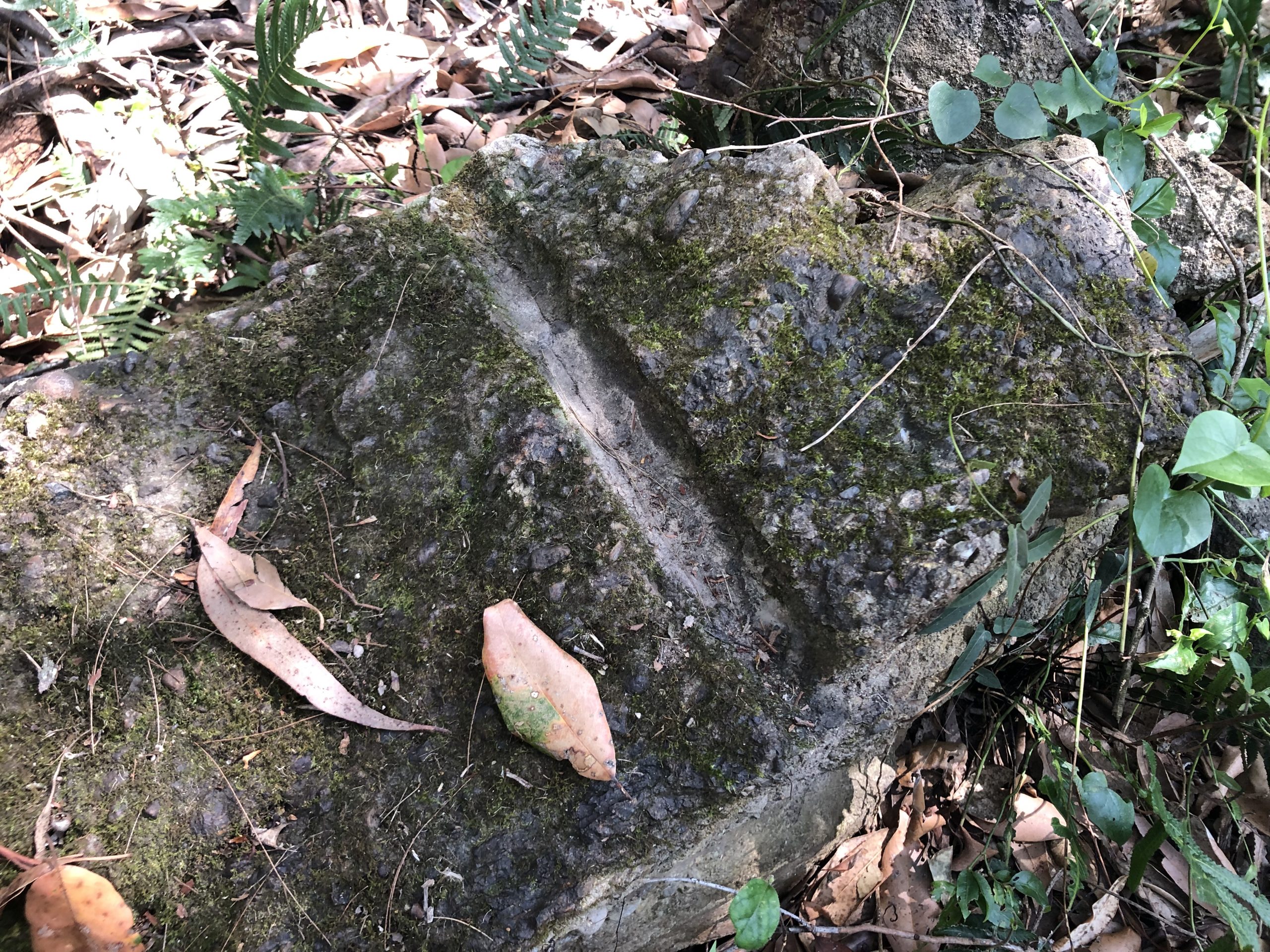
After the initial construction of roads, the council does not appear to have used the Lambton colliery quarry again. The company sold the land to developers in 1956 and the location of the former quarry is now hidden by housing. In Addison Road the council purchased the quarry in 1896 and continued using it until the 1920s. The land is vacant today, but still has a few reminders of its past use lying amongst the undergrowth.
A 1906 view over New Lambton, with the Lambton colliery quarry in the hillside above. Photo by Ralph Snowball. Newcastle University, Living Histories.The Lambton colliery quarry is now obscured by housing.At the top of Addison Road a drill hole in a fallen rock is a reminder of the site’s past use as a quarry..Portion of Barrett’s 1910 map showing the Lambton colliery quarry, and the New Lambton Council quarry at the top of Addison Road. Newcastle University, Living Histories.
The article above was first published in the December 2023 edition of The Local.
Additional Information
New Lambton colliery began operations in June 1868 and a township soon formed around it. The following year The Newcastle Chronicle reported on the progress of the town, including the state of the roads …
As yet no streets have been formed, and, with the exception of a kind of a main road, leading through the mostly inhabited part of the township, there is no other thoroughfare, and from the multiplicity of the stumps that are still visible, even in close proximity to the houses, perambulating the village in a dark night must be a difficult undertaking. It would be most advisable for the residents to take early steps for making one or two tolerably passable streets, for the lack of this convenience in any township is a serious drawback.
Despite this advice for better roads, seven years later the roads were still in need of much attention.
Bad roads are now the order of the day, and between Old and New Lambton they are in a very bad and almost impassable state, owing chiefly to the recent heavy rain.
The Maitland Mercury and Hunter River General Advertiser, 5 August 1876
Twelve years on, the lack of decent roads was a leading inspiration for the residents of New Lambton to press for the creation of a municipal council.
It is rumoured that an effort is to be made to have this town incorporated and proclaimed a municipality. There are at present no roads or streets other than the main road to Newcastle that can lay any claim to the name. They are simply cart tracks and foot tracks and when one of these becomes too bad to travel on owners of vehicles simply go and pick out another, which for a time suits them, and so on. If the place was incorporated, this state of things would soon become a thing of the past, because regular streets would be laid out, made, and maintained, and every traveller and resident would enjoy the benefit – a benefit which would far more than recoup the few shillings per year the inhabitants would pay in rates.
Newcastle Morning Herald and Miners’ Advocate, 29 March 1886.
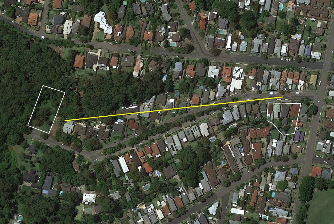
Addison Road Quarry
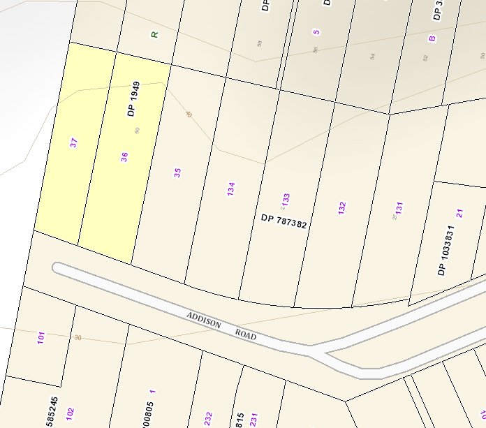
Within a year of the council being formed in 1889, the Improvement Committee was seeking permission from Alexander Brown (managing director of the New Lambton colliery) to use their quarry for road making materials. At the council meeting of 12 March 1890 the committee recommended …
That a deputation wait upon Mr. A. Brown to see what terms he would allow the council to open out quarries upon lots 36 and 37, near Mr. Hincks’ house; also to see upon what terms he would allow the council the use of 400yds of rails and sleepers. 2. That a tramway be laid from the proposed quarries down to near Mr. Hilton’s place, a distance of about 400yds; also that a tip and shoot be erected.
Newcastle Morning Herald and Miners’ Advocate, 14 March 1890.
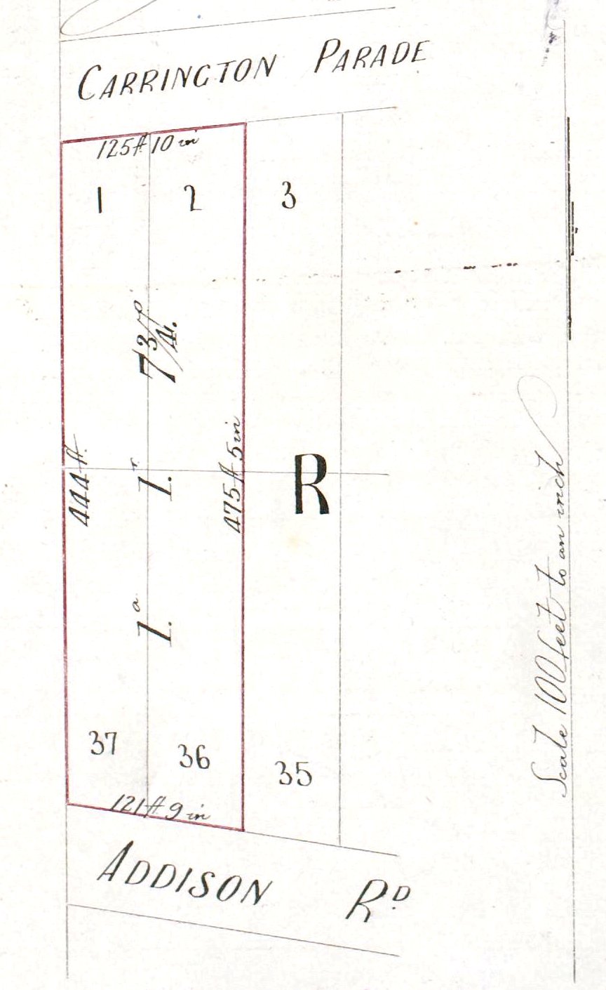
Lots 36 and 37, Section R, DP1949 – the location of the quarry referred to in the 12 March 1890 meeting of New Lambton council. SIX maps.
The 12 March 1890 meeting of New Lambton council refers to the quarry being “near Mr Hincks” house. Land title Vol-Fol 1468-110 shows that Richard Hincks’ property was at the top of Addison Rd, opposite the quarry. Sometimes the newspapers referred to the quarry as “Hincks quarry”, simply because it was near his house.
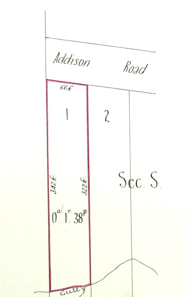
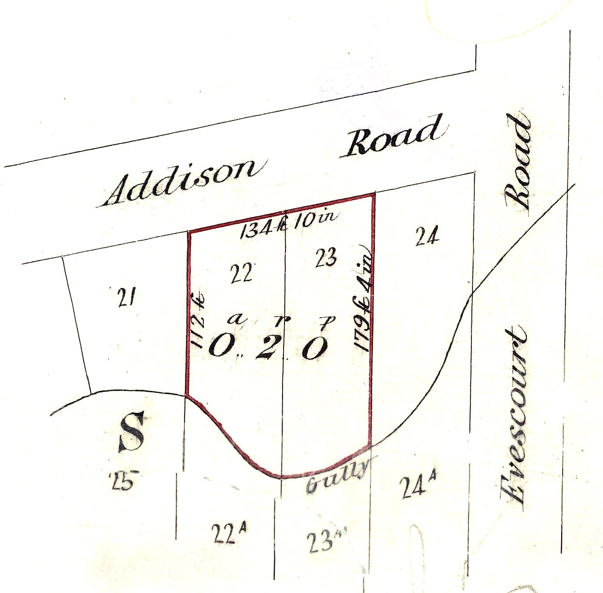
The improvement committee’s report recommended that a tramway be laid “down to near Mr. Hilton’s place, a distance of about 400yds”. Land title Vol-Fol 992-68 shows that Matthew Hilton owned lots 22 and 23 near the bottom of Addison Rd.
Matthew Hilton’s property, Addison Rd, New Lambton. Vol-Fol 992-68.
We have no information on the exact route of the tramway, but a straight line of 400 yards in length (shown in yellow below) matches the distance between the quarry and Hilton’s property.
The quarry (left) and Hilton’s property (right), with the distance between them being approximately 400 yards.
The council’s request to use the colliery’s quarry proved successful. The council meeting of 26 March 1890 reported …
From the Mayor and Alderman Gray, who had interviewed Mr. A. Brown, when that gentleman offered to allow the council to work the gravel quarry on lots 36 and 37 on the New Lambton estate at the rate of 4d per yard, and the use of rails and sleepers for a tramway free of charge
Newcastle Morning Herald and Miners’ Advocate, 28 March 1890.
Four tenders were received, resulting in the tender of Hinton & Co., being accepted for the sum of £23 18s 6d. The tender of Hinton and Co. was also accepted for the construction of a tramway hopper, for the sum of £79 18s.
Newcastle Morning Herald and Miners’ Advocate, 16 May 1890.
Hinton completed the tramway, but being more work than he anticipated he asked the council for extra payment. The curt response was that …
… the contractors to be informed of the previous decision of the council to the effect that they cannot feel justified in paying extras, as the work for which extras are claimed was provided for in the specifications.
Newcastle Morning Herald and Miners’ Advocate, 16 August 1890.
In February 1896 the council resolved to “negotiate with the New Lambton Company for the purchase of lots 36 and 37, section S, near Hinck’s, for a quarry” and also “to place the tramline in order.” The Company agree to sell the the two lots for £15 each, but after a further inspection of the site the Mayor reported that …
… he was of opinion that the council would act wisely in purchasing four allotments from the New Lambton Co., as it was clear the gravel extended with a much larger face in the two allotments through from the present quarry. Alderman Williams moved, “That £50 be offered to the company for the four lots.”
The sale of 4 lots of land totalling 1.2 acres was completed in September 1896.
Sale of land from “The New Lambton Land and Coal Company” to “The Borough of New Lambton”, September 1896. Vol-Fol 1203-130.
In October 1896, the newspaper reported that
A boy named Benjamin Taite met with a painful accident yesterday morning. He was walking along the rails of the Quarry line, and somehow or other slipped and fell on his arm, breaking both bones near the wrist.
It is not absolutely certain which “Quarry line” is referred to, but I strongly suspect that it is the Addison Road quarry line, as this is the quarry recently purchased by the council and which they had expressed their intention earlier in the year “to place the tramline in order.”
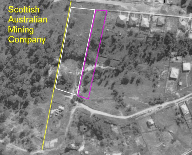
There are various references to the quarry in the ensuing years. At a 1924 council meeting, correspondence was received from “S.A. Mining Company, granting permission to council to remove gravel from Hincks’ quarry.” At first glance, this appears a little odd, as the council owned Hincks’ quarry, so why would they need permission from the Scottish Australian Mining Company? This can be explained by viewing the extent of the quarry in a 1944 aerial photograph, and overlaying land boundaries, and noting that the quarry extended into Scottish Australian Mining Company land holdings. Presumably this extension westwards was because that was where good gravel could be obtained.
A 1944 aerial photograph overlaid with council’s 1896 purchase of land for a quarry (white) and the extension purchased in 1925 (purple), which shows that the quarry also extended westwards into the land holding of the Scottish Australian Mining Company.
In October 1924 New Lambton Council …
… on the recommendation of the Mayor, decided to increase its quarry property. The council will acquire two blocks of land at a cost of £25 each. This land adjoins Hinks’s quarry, and includes another block. The land contains gravel for street construction and repairs.
Newcastle Morning Herald and Miners’ Advocate, 9 October 1924.
This land purchase (lots 3 and 25 of Section S of DP1949) was completed in April 1925. Vol-Fol 3735-122.) There is a brief mention of Hincks’ Quarry in 1926.
The steam lorry had been engaged for the fortnight in street patching with gravel from Fern Quarry. The motor lorry arrived on July 8, and was being used in carting gravel from Hincks’ quarry, and was doing good work.
Newcastle Morning Herald and Miners’ Advocate, 15 July 1926.
After this date there are no more mentions of this quarry being actively used, presumably because the council was now sourcing its gravel requirements from the larger Fern Quarry (located on Peatties Road Kotara) that they purchased in August 1926. (Vol-Fol 3808-23)
Lambton Colliery Quarry
A note on street names: The Lambton colliery quarry was used for the construction of streets in the northern part of New Lambton, on the Commonage. Due to a mix up many of these streets were given one name by the council, and a different name by the Lands Department in Sydney. Eventually the council had to give way to the Lands Department names. Hence a number of street names mentioned below in council reports are now known by a different name. See the article “Sadly Bungled Street Names” for further details.
In June 1890, Thomas Croudace, alderman on the New Lambton council and also manager of the Lambton Colliery …
… offered on behalf of the company, to allow the council to quarry chatrock on the Lambton Company’s estate at a price to be fixed at a future date.
Newcastle Morning Herald and Miners’ Advocate, 7 June 1890.
Chatrock is gravel smaller than pea gravel, but larger than sand. In April 1891 the council made formal moves to request use of the Lambton colliery quarry.
Alderman THOMAS moved, that a deputation, consisting of Aldermen Capewell, Lonsdale, and Hitchcock, wait upon Mr. Croudace, and ask his permission to use the colliery quarry for Dent and Gibson streets contracts.
Newcastle Morning Herald and Miners’ Advocate, 24 April 1891.
The Mayor (Thomas Croudace) intimated that he would do his utmost as regards letting the council have gravel to make Dent and Gibson-streets.
Newcastle Morning Herald and Miners’ Advocate, 8 May 1891.
The request was granted and the council then called for tenders for the extracting gravel from the quarry. In July 1891 the contractors, Messrs Friel and Curran, wrote to the council …
… stating that the gravel in the colliery quarry was much heavier than in Russell-street, and asking for consideration; the means of conveying it would also be inconvenient and costly.
Newcastle Morning Herald and Miners’ Advocate, 3 July 1891.
Although no formal resolution of the council regarding the transportation of gravel is recorded in newspaper reports, the council decided that a tramway down the hill was required, and sought the co-operation of the Lambton Colliery in its construction. In October 1891 the council resolved …
… That Aldermen Lonsdale and Capewell wait upon Mr. F. Croudace in regard to the speedy completion of the quarry tramway … The MAYOR and Alderman DEAN reported that Mr. F. Croudace had promised to provide rails and sleepers for the tramway in Dent-street.”
With a lack of worksite security combined with the lure of adventures, soon afterwards the paper reported that
ON Tuesday evening a serious accident happened to a boy, aged 13 year, son of Mr. Simeon Davies, New Lambton. It appears the boy, with a companion, was riding on some full skips, which were being brought down a steep incline from the quarry in the Lambton Colliery paddock. The skips left the rails and threw the boys off, injuring the boy Davies severely. He was at once conveyed home and medical assistance procured, when it was found that his arm had suffered a compound fracture, and his leg was fractured above the ankle. It is feared the injuries to the arm will necessitate amputation. The boy at present is in a critical condition.
It is unclear when the council ceased using the Lambton colliery quarry as a source of gravel. The last mention in the newspapers is in June 1892 where the Mayor is permitted to engage men “in quarrying gravel in Russell-street, also in the colliery quarry.” Presumably after the council purchased the Addison Road quarry in 1896, there would have been little need to use the Lambton colliery quarry.
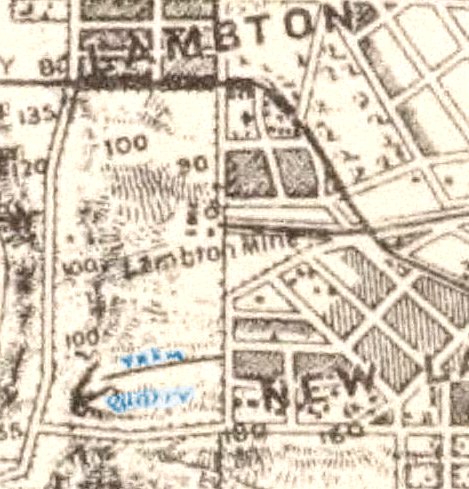
Portion of Parrott’s 1893 map, that shows the Lambton colliery quarry, the tramway leading down to Wickham Road, with the words “Tram” and “Quarry” colourised for emphasis. National Library of Australia.
Close up view from 1906 of the Lambton colliery quarry and the path of the former tramway down to the streets of New Lambton. Newcastle University, Living Histories.
In a 1938 aerial photograph the path of the quarry tramway can be clearly seen leading from the former quarry near the intersection of Croudace St and Russell Rd, down to Wickham Rd. Newcastle University, Living Histories.
The land on which the quarry was located was sold by the Scottish Australian Mining Company in July 1956 (Vol-Fol 7114-143) and by the mid 1960s suburban development of the area was well underway.
Aerial photography from 1966 shows ongoing suburban development in the former Lambton colliery pit paddock and quarry area. NSW Historical Imagery.
Other New Lambton quarries
The reports of the meetings of New Lambton council mention numerous other local quarries in the period 1899 to 1938. Some of these are named by location. Some are named after a person, although it is often not clear whether the person is the owner of the quarry, the main worker in the quarry, or just someone who lived nearby as was the case with Hincks’ quarry.
"Alderman CROUDACE offered, on behalf of the company, to supply the ashes and to allow the council to quarry chatrock on the Lambton Company's estate at per yard; the price to be fixed at a future date."
"The foreman reported verbally that the Mayor had promised to allow the council to obtain gravel from the colliery quarry. Alderman THOMAS moved, that a deputation, consisting of Aldermen Capewell, Lonsdale, and Hitchcock, wait upon Mr. Croudace, and ask his permission to use the colliery quarry for Dent and Gibson streets contracts."
"From Messrs. Friel and Curran, stating that the gravel in the colliery quarry was much heavier than in Russell-street, and asking for consideration; the means of conveying it would also be inconvenient and costly."
"From Mr. Alexander Brown, managing director of the New Lambton Company, offering lots 36 and 37, section R, for £15 each as a quarry, the council to pay cost of transfer."
Motiona at New Lambton Council "That the managing director of the New Lambton Land and Coal Co. (Mr. A. Brown) be requested to dedicate and align Carrington Parade and Addison-road for the purpose of enabling the council to form and make the roadway to the quarry in a proper manner."
"A boy named Benjamin Taite met with a painful accident yesterday morning. He was walking along the rails of the Quarry line, and somehow or other slipped and fell on his arm, breaking both bones near the wrist."
Correspondence from "S.A. Mining Company, granting permission to council to remove gravel from Hinck's quarry, at the same royalty and conditions applicable to Fern quarry, until such time as the latter quarry was again available."
"The steam lorry had been engaged for the fortnight in street patching with gravel from Fern Quarry. The motor lorry arrived on July 8, and was being used in carting gravel from Hincks' quarry, and was doing good work."
"A landslide in Addison-road, New Lambton, was not due to mine subsidence, according to an expert's report. An inspection of a nearby disused gravel quarry indicated the underlying strata consisted of about
four feet of clay shale sub-soils lying on a bed of hard conglomerates."
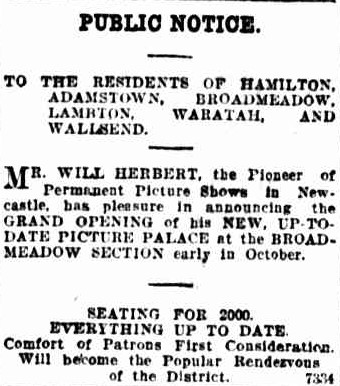
William Herbert was a pioneer of the cinema scene in Newcastle. Born in the United States, he moved to Newcastle in 1907 and began showing the new ‘moving pictures’ at various locations in Newcastle. In October 1910 Herbert announced plans to screen films in the open air at the Hamilton Rugby League ground on the north side of Belford St. The first night was a disaster. “Owing to the boisterous nature of the weather the moving pictures could not be held as the screen was blown down in the afternoon.”
Despite the initial setback, Herbert persevered and regularly screened movies at the ground until 1912 when he opened a permanent theatre at the Nineways Broadmeadow. Seating 2000 people, the grandiosely named “No. 1 Picture Palace” was a basic structure with asphalt floor and canvas roof.
During 1923 and 1924, Herbert ingeniously managed the complete reconstruction of the building “without temporarily shutting down the theatre or seriously inconveniencing his patrons.” Corrugated iron walls were removed gradually and replaced with brick, steel girders installed, and the canvas roof replaced over a three-week period. “There were times when parts of the theatre had two coverings, but at every screening the audience was protected from the weather.”
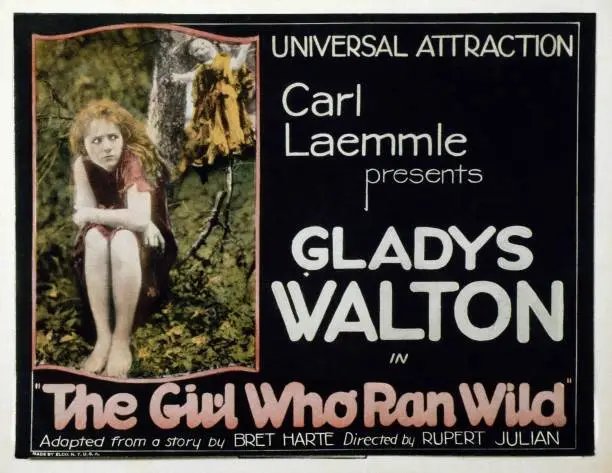
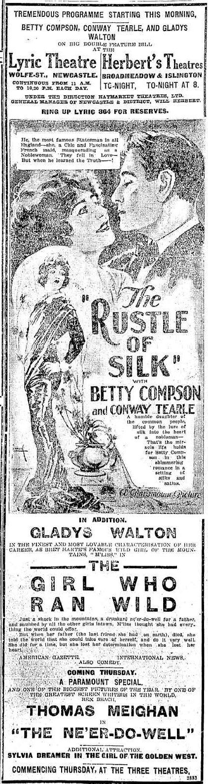
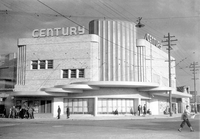
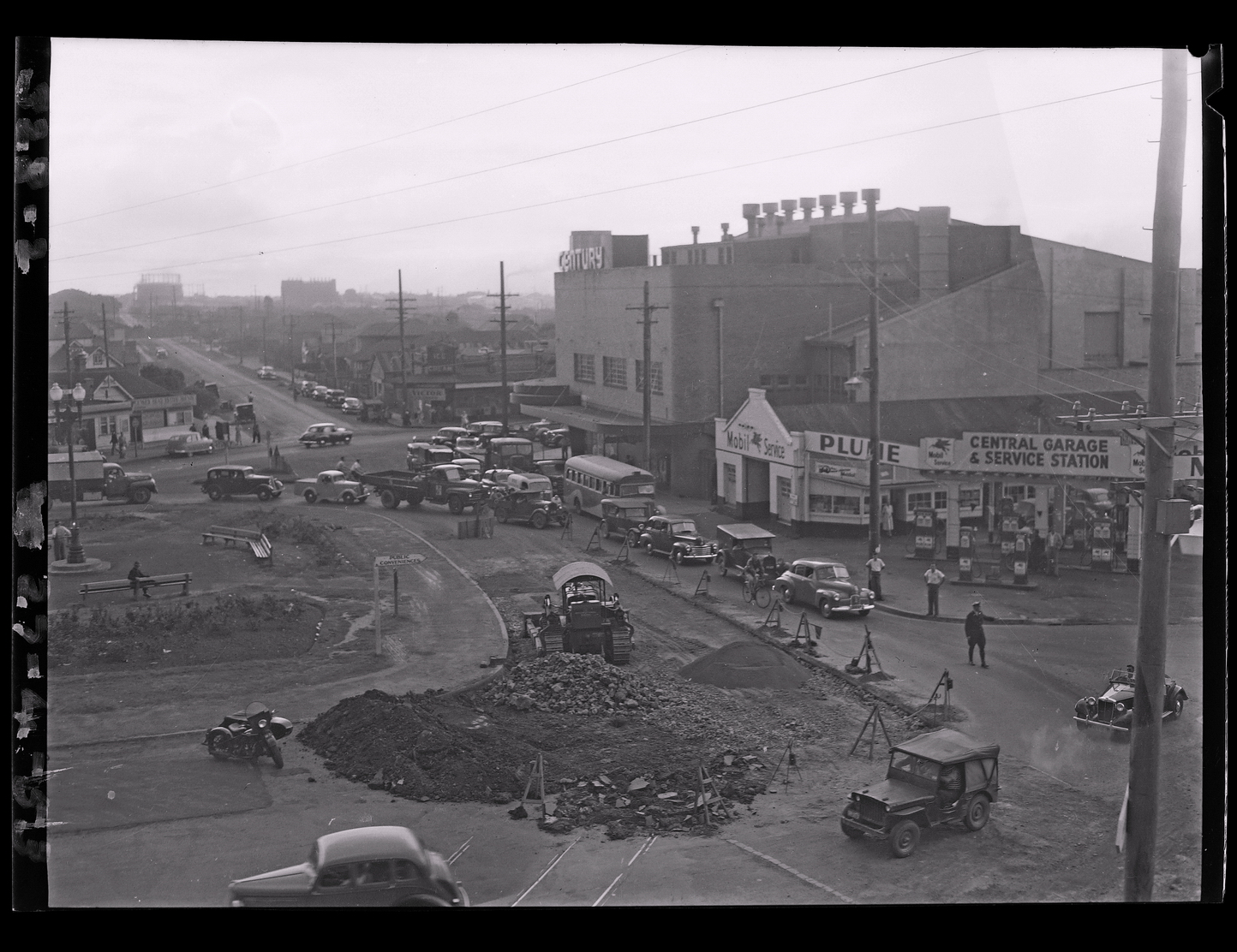
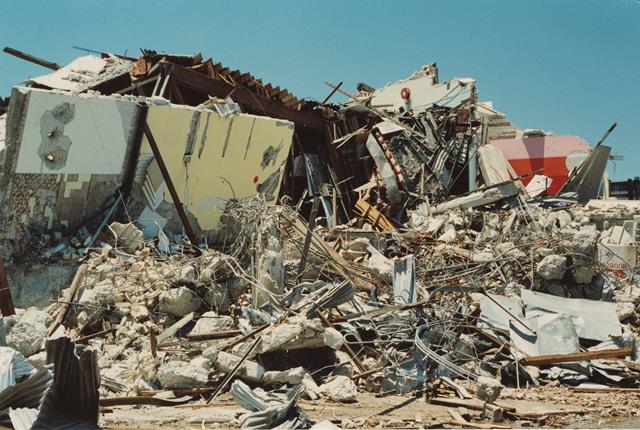
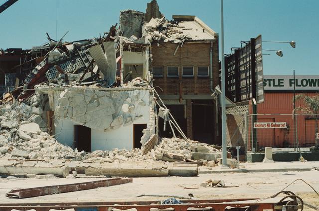
A photograph of the new “Herbert’s Theatre De Luxe” can be dated by close inspection of the poster on the right-hand side. It advertises Gladys Walton in the silent film “The Girl Who Ran Wild” that screened in September 1923. Herbert sold the theatre in 1933 and in 1941 the new owners announced plans for its demolition and erection of a new building. At a cost of £40,000 and a seating capacity of 1600, the new “Century Theatre” opened in April 1942 and had its final screening in September 1973. The building lay derelict for a while and was then variously used as a truck repair workshop, gaming arcade, and finally as a church. Badly damaged in the 1989 earthquake the Century Theatre was demolished soon afterwards.
According to a 1918 biographical article, Will Herbert was born in the town of Manchester, New Hampshire in the USA. Confusingly, an obituary in 1947 states that he “was born in New Hampshire, England, and was taken to America at the age of three” while another obituary states that he “was born in Lancashire”.
The kind of person he was is perhaps best illustrated in that he was an actual example of the cliche of running away from home to join the circus …
Mr. Herbert seems to have had a penchant for travelling, for at 16 – without his parents’ consent – he attached himself to Forepaw’s Circus, which at the time was second only in size and importance to the great Barnum and Bailey’s Circus.
Newcastle Morning Herald and Miners’ Advocate, 5 April 1918.
After touring with the circus for a couple of seasons, Herbert started a bakery business in Boston, bought into a French cafe in New York, went to San Francisco and became chief steward on a steam ship trading with the eastern Pacific. He then served as a commissariat officer on the troopship Naomi in the war between the United States and Spain, and then subsequently on a trans-Atlantic liner the General Grant, sent to the Philippines to quell an uprising.
It was while in the Philippines that Mr. Herbert conceived the idea of taking up motion pictures.
Newcastle Morning Herald and Miners’ Advocate, 5 April 1918
In 1905, Will Herbert was part of a syndicate that secured the rights to film and screen the Lightweight Championship boxing match between Jimmy Britt and Oscar “Battling’ Nelson, held at San Francisco on 9 September 1905.
Britt-Nelson boxing match in San Francisco, 9 September 1905. Library of Congress.
Soon afterwards, Herbert headed to Australia to exhibit the film of the fight.
Mr. Herbert, of the syndicate which secured the moving pictures of the Britt-Nelson fight in America for the world’s light-weight championship, arrived from America by the Sierra for the purpose of exhibiting the pictures throughout Australasia. He will open the Queen’s-hall, Pitt-street, on Monday next for a season, and a holiday matinee will also be given. Popular prices will be charged. Over 18,000 people witnessed this contest, which was very exciting; and the film representing it is over a mile in length.
Over the next two years Herbert toured all parts of Australia and New Zealand, showing the film in rented halls and theatres. He made at least two visits to Newcastle, in November 1905 and again in February 1906.
Mr. Herbert said that on his first visit to Newcastle he had noticed the possibilities for the establishment of permanent pictures.
Newcastle Morning Herald and Miners’ Advocate, 5 April 1918
Herbert appears to have settled permanently in Newcastle sometime in late 1907 or early 1908. By February 1908 he is mentioned as the manager of “Kings American Picturescope”, screening films at the Victoria Theatre in Perkins Street. He then rented the “Central Hall” in May 1908 for a period of 18 weeks, and also screened films at the Newcastle Sports Ground.
Hamilton Rugby League Ground
Will Herbert first screened moving pictures in the Broadmeadow area in the open air at the Hamilton Rugby League Football Ground. The first scheduled show on 22 October 1910 was cancelled due to inclement weather, however within a few weeks the paper reported …
The fine picture entertainment given by Mr. Will Herbert at the Rugby League Ground, Hamilton, is apparently growing rapidly in popularity, judging from the increasingly large audiences. Last night the new programme was witnessed by a very large attendance.
Excerpt of an 1884 map of Newcastle, showing the location of the Hamilton Rugby League Ground between Tudor and Belford Streets. Newcastle University, Living Histories.A Google Earth image showing the approximate location of the Hamilton Rugby League Football Ground. The location of Herbert’s Theatre De Luxe is outlined in red.
Will Herbert continued to regularly screen pictures at the ground until the final screening on Saturday 4 May 1912. The land occupied by the Rugby League Ground was later subdivided into 41 lots by the A. A. Company and sold in April 1918.
No. 1 Picture Palace
In August 1912, Will Herbert announced in a public advertisement his intention to open an “up-to-date Picture Palace” in Broadmeadow, capable of seating 2000 persons.
Herbert’s “No. 1 Picture Palace” at Broadmeadow opened on Saturday 2 November 1912, screening “Sweet Nell of Old Drury” starring Miss Nellie Stewart. A report on the opening noted that …
The attendance numbered just on 2000, and many were unable to gain admission. Extra seats were brought in, but these were not sufficient to accommodate those anxious to get in. The structure is a very commodious one, and commands an excellent position at the junction of the tram lines. The building measures 187ft by 85ft, and is admirably adapted for picture entertainment. The exterior was brilliantly illuminated for the opening performance. Three large stars and a Maltese cross formed of different coloured electric lights gave the outside a most picturesque appearance. The vestibule is attractively laid out, and the whole of the floor space of the building will shortly be asphalted. Patent spring back chairs are to be used for the higher-priced seats. The chairs already in use are very comfortable, and in every other respect patrons are well catered for.
Newcastle Morning Herald and Miners’ Advocate, 4 November 1912
By May 1913 further improvements to the theatre had been completed.
Herbert’s Picture Palace at Broadmeadow has now been completely roofed in with waterproof canvas, which will render it cosy and warm for the winter months.
Newcastle Morning Herald and Miners’ Advocate, 6 May 1913
Herbert’s Theatre De Luxe
Originally the photograph of Herbert’s Theatre De Luxe was loaded into the Living Histories site with no attributed date. Noting from the article of June 1924 that the construction/renovation of the theatre was “spread over fourteen months”, and also noting from the photo that the tramline to Adamstown up Brunker Road is not yet electrified (which was completed in January 1925), indicates that the photo was taken sometime in 1923 or 1924.
Getting a more exact date on the photo relies on identifying the movie being exhibited at the time of the photo, by carefully examining the poster on the right hand side of the entrance.
Taking a snip of the photo and enhancing the contrast, you can just make out the name “Gladys Walton” and the name of the film as “The Girl Who Ran Wild”. Additionally, a faint outline of a seated girl can be made out that matches the profile of the movie poster below.
Searching newspaper advertisements in 1923 and 1924 reveals that the film was screening at Herbert’s Broadmeadow Theatre in the week beginning Monday 17 September 1923.
Advertisement for screening of “The Girl Who Ran Wild” at Herbert’s Theatre, Broadmeadow. Newcastle Morning Herald and Miners’ Advocate, 17 September 1923.
According to Cork and Tod’s book “Front Stalls or Back?”, Herbert divested control of his theatres to Newcastle Theatres Pty Ltd in 1933. Herbert retired in 1935 and visited the United States. A year later in January 1936 the directors of the Newcastle Theatres induced Herbert to take on the supervision of their theatres, including the De Luxe at Broadmeadow, Roxy at Hamilton, and Regent at Islington.
William Herbert retired again in 1941, and died on 11 November 1947 in Hamilton, at the age of 80.
Century Theatre
A start will be made on Monday on the new modern theatre at Broadmeadow. With equipment and furnishings the expenditure will exceed £30,000. The contract is the biggest announced in northern New South Wales this year. The building will occupy a splendid central site, with frontages to Chatham road and the Pacific Highway. To enable operations to proceed, it will be necessary to demolish the present theatre and other buildings erected by Mr. W. Herbert, founder of Herbert’s Theatres, 25 years ago.
Newcastle Morning Herald and Miners’ Advocate, 19 April 1941
The new Century Theatre opened on Friday 17 April 1942 with a screening of the Technicolor film “Aloma of the South Seas” starring Dorothy Lamour.
The Century Theatre, erected on the site of Herbert’s theatre in Broadmeadow, opened in April 1942. Photo from Cinema Treasures.Alterations to to roads at Nineways, Broadmeadow, with the Century Theatre in the background. 27 April 1953. Photo by Len Webber. Newcastle Library, Hunter Photobank. Accession Number 515 000075The Century Theatre, Broadmeadow, in the process of demolition after damage from the 1989 earthquake. Photo by Ron Morrison. Newcastle Library, Hunter Photobank. Accession Number 004 001134The severely damaged Century Theatre, Broadmeadow, being demolished. Photo by Ron Morrison. Newcastle Library, Hunter Photobank. Accession Number 004 001135
"Mr. Herbert, of the syndicate which secured the moving pictures of the Britt-Nelson fight in America for the world's light-weight championship, arrived from America by the Sierra for the purpose of exhibiting the pictures throughout Australasia."
"At the King's Hall on Saturday evening, Mr. Will Herbert introduced to Newcastle the celebrated motion pictures of the Britt-Nelson contest for the lightweight boxing championship of the world."
"The attendances at the Picturescope Palace, Newcomen-street, during the week, have been well up to the average, and Mr. Herbert, the manager, expresses himself well satisfied with the support that has so far been accorded his efforts to establish a permanent picture show in Newcastle."
"Mr. Will Herbert, formerly of the Picturescope Palace, Newcastle, announces that the first of a series of a continentals will be given under his direction at the Rugby League Ground, Hamilton, this evening."
"Owing to the boisterous nature of the weather on Saturday, the continental and moving pictures, promoted by Mr. Will Herbert, on the League Football Ground, at Hamilton, could not be held. The
screen was blown down in the afternoon, and at night there was no attendance of the public."
"The fine picture entertainment given by Mr. Will Herbert at the Rugby League Ground, Hamilton, is apparently growing rapidly in popularity, judging from the increasingly large audiences."
Herbert's Picture Palace at Broadmeadow has now been completely roofed in with waterproof canvas, which will render it cosy and warm for the winter months.
"The Girl Who Ran Wild, the Universal attraction starring Gladys Walton, which will be screened at the Lyric and Herbert's Theatres, Broadmeadow and Islington, on Monday next, is the latest and most appealing screen version of Bret Hart's story M'liss."
At the Lyric and Herbert's Pictures to-day there will be shown for the last time the Paramount special entitled "The Rustle of Silk," with Betty Compson in the lead. Gladys Walton is also seen in "The Girl who Ran Wild."
Long article detailing "the conversion of Herbert's Broadmeadow Theatre from an unprepossesssing building to one of the most modern picture exhibition houses in Australia."
"At the request of the Directors of Newcastle Theatres Ltd., Mr. William Herbert has resumed the supervision of the circuit embracing the De Luxe (Broadmeadow), Roxy (Hamilton), and Regent (Islington), Theatres."
"A start will be made on Monday on the new modern theatre at Broadmeadow. With equipment and furnishings the expenditure will exceed £30,000. To enable operations to proceed, it will be necessary to demolish the present theatre and other buildings erected by Mr. W. Herbert, founder of Herbert's Theatres, 25 years ago. "
"Another fine addition to the architectural grandeur
of the Newcastle district is the new Century Theatre at
Broadmeadow. Erected at a cost of over £40,000, and
with a seating accommodation of over 1600, the theatre
will-be opened officially on Friday night, at 7.45 o'clock"