My local history article for the July edition of the Lambton Local is out. Read all about it and find out why I was so overjoyed to find this hole in the ground … 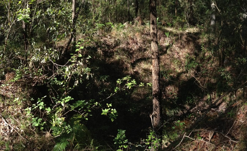 … or just watch the video.
A hole lot of joy
Reply

My local history article for the July edition of the Lambton Local is out. Read all about it and find out why I was so overjoyed to find this hole in the ground … … or just watch the video.
When I moved to Lambton and read through the Newcastle Family History Society’s “The Story of Lambton”, I was intrigued by the photos of a picnic destination variously described as “Nellie’s Glen”, “Glen Lewis”, or “Paddy Lewis Dam”, and I wondered where this beautiful spot was. The location appeared idyllic enough that it even featured on a postcard in the early 1900s. I set myself the challenge of finding “Paddy Lewis”, and recently, after assistance from some old maps, Google Earth and the National Museum of Australia, I was able to confirm the location of this picturesque site.
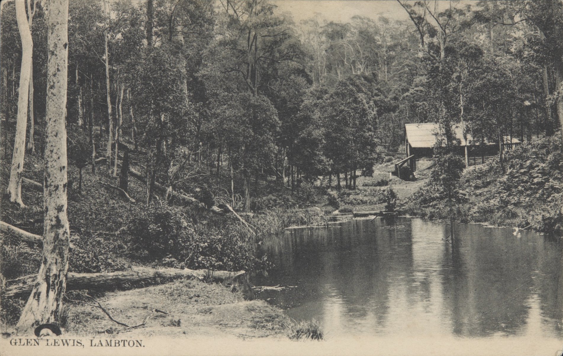
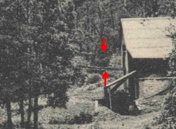
But pictures can be deceptive, for this is no ordinary bushland setting, but an industrial scene. That’s not a picnic shelter in the background, but an engine house of the Lambton colliery, with a boiler and steam driven winding engine used to pull steel cables that went down a shaft into the mine to haul coal skips from distant parts of the underground workings. The engine, for reasons now unknown, was called “Paddy Lewis” and the dam in the foreground supplied water to the steam boiler.
The engine was first erected in 1878 under the supervision of Thomas Croudace, the manager of Lambton colliery. In 1904 a fire in the middle of the night destroyed the engine and it had to be replaced. The engine operated up until 1921 when all the payable coal had been extracted from the western portions of the mine, and the engine house was then dismantled. Paddy Lewis dam is still there today, nestled in a gully in the bushland below John Hunter Hospital, but now overgrown with reeds and vegetation. Nothing remains of the engine house apart from a few fragments of brick foundations, this industrial scene having now returned to an ordinary bushland setting.

The article above was published in the July 2015 edition of the Lambton Local.
My quest to confirm the location of Nellie’s Glen/Paddy Lewis dam took about six months, and a significant contributor in that quest was Robert Watson. Shortly after I moved to the area and read “The Story of Lambton” I wanted to find this location. A short time later I met Robert for the very first time, and towards the end of a wide ranging discussion about local history, and without him knowing that I was already interested, he said to me “I’ve got a challenge for you – to find the location of Nellie’s Glen/Paddy Lewis dam!” Thus began a six month quest, with each of us sharing information, ideas, theories, suggestions, encouragement and inspiration.
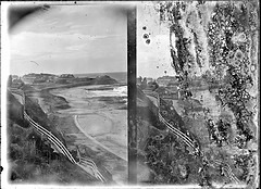
As well as the photo in “The Story of Lambton”, the University of Newcastle Living Histories site also has a picture of this location, captioned as “‘Nelly’s Glen’ [& Paddy Lewis Dam], Lambton”. It took a while before I realised that the two images, while very similar, are not the same. Note in the photos below how the reflections in the water are different. As an interesting exercise for the reader, see what other differences you can spot, then try to work out which photo was taken earlier than the other.

I subsequently found that the lower image was used in a postcard in the early 1900’s, a copy of which was held by the National Museum of Australia, who kindly obtained a good quality scan of the postcard for me. (In 2024 during a visit to the National Library of Australia, I was able to identify that the photographer of the upper image was George Henry Dawkins of Lambton.)
Quite early in my search for this location, in February 2015, based on information in a 17 Nov 1904 newspaper article about a fire at the Paddy Lewis engine house, I made an educated guess about the location of the dam.
The image above is from an email I sent on 7th February 2015, where I suggested that the area marked B was possibly the location of Paddy Lewis dam. I visited the location on 13th March 2015 and took the photo below, and found it to be a quite plausible location, but could find no evidence of any buildings, and nothing to confirm my suspicion.
Over the next few months I walked to quite a few locations in the Jesmond bushland and in Blackbutt Reserve, and found a few other plausible locations, but in so doing began to wonder if I would ever confirm the location, as I found that each shallow depression in a gully in the bush looks like every other shallow depression in a gully in the bush!
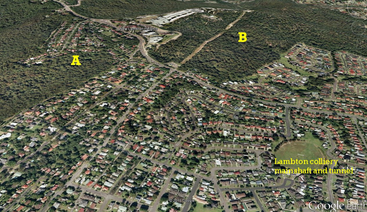
Robert Watson then provided two key pieces of information. Firstly, some recollections told to him by an old Lambtonian giving directions of how he used to walk to “Paddy Lewis Dam”, and secondly a scan of a portion of an old Craigie’s map that showed a dam, an engine house and shaft.
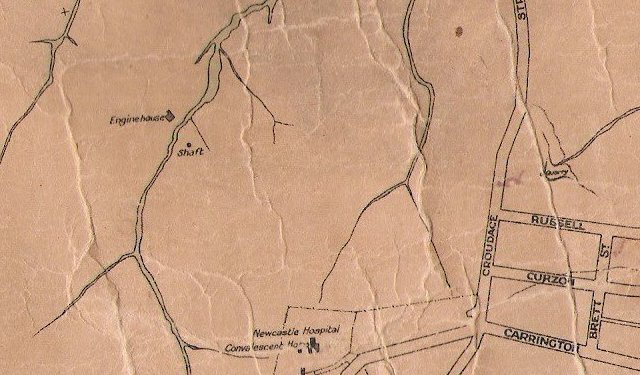
This matched my suspected location, and also on noting that the engine house and shaft were on opposite sides of the gully, inspecting the photo more closely I noticed the hint of cables exiting the building and crossing the gully, which matched the map.
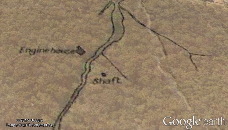
I was able to take the image of the old map and load it into Google Earth as an overlay, and stretch and rotate the image to align it with modern features. After doing this I could determine the latitude/longitude of the various features such as the engine house and shaft.
I then loaded these coordinates into the GPS tracking app I use on my smart phone, and headed into the bush. Here’s what happened …
I found some fragmentary remains of the engine house, and the remains of the old winding shaft. I recorded the exact GPS coordinates of the shaft, and when I got home compared it with the predicted location based on my overlaying the old map into Google Earth. The difference was only 23 metres – a testament to the accuracy of the old map makers and the power of Google Earth.

Danger. If you encounter this old shaft – do not enter this depression. The shaft was last used in 1921, and 94 years of erosion has probably blocked up the shaft, but it is possibly still deadly. Based on the depth of the coal seam and the ground altitude of this location I estimate the shaft was originally about 50 metres deep, and you do not want to find out by accident exactly how deep it was.
[Update 18 Dec 2018: I visited the shaft again today and took some rough measurements. On the high side of the hill it was 5.5m from the lip to the bottom. On the low side of the hill it was 3.5m from the lip to the bottom. The circumference of the lip was about 34m, making the diameter about 11m.]
As well as the Craigie’s map that showed the dam, engine house and shaft, I found in Newcastle Library’s Local Studies section an old map from the Scottish Australian Mining Company from 1925, that shows the dam and shaft (little black square), but no engine house, as it was dismantled in 1921.

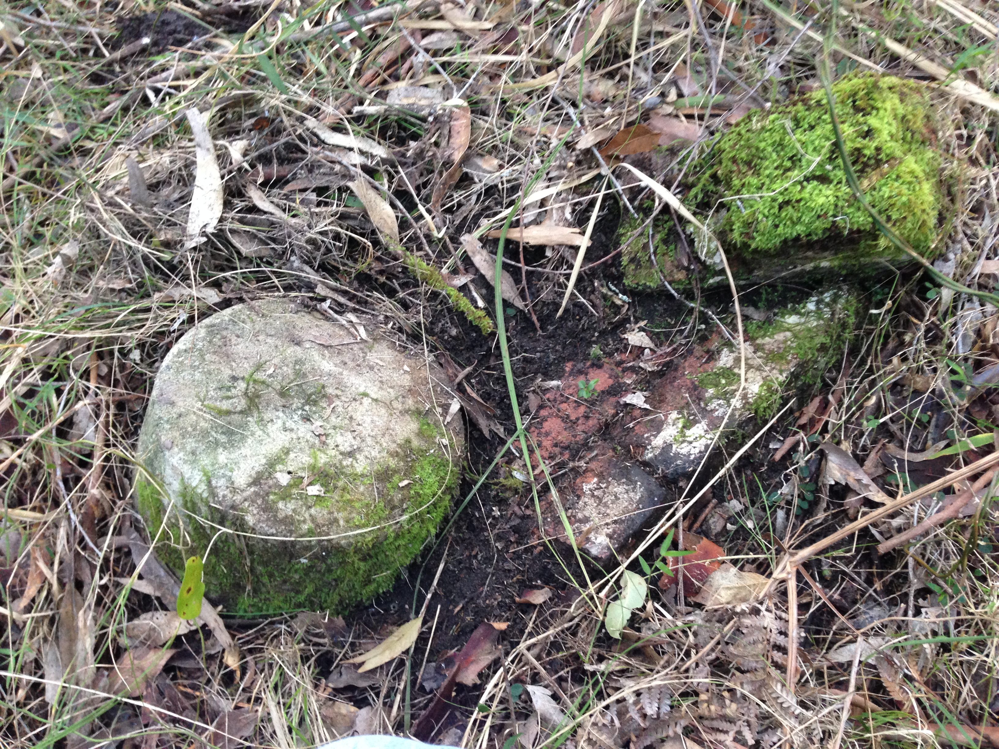
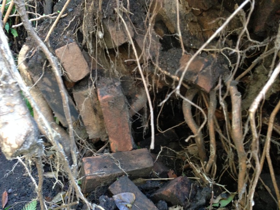
In July 2015 I revisited the site with some friends, and this time ventured into and under the lantana growth towards the bottom of the gully, and found substantial remains of the brick foundations of the engine house – numerous piles of moss covered bricks.
At one place, a large tree had grown over the foundations, and when it toppled over fairly recently, it has pulled up and exposed bricks that were previously under the ground.
Geoff Bates, who used to visit Paddy Lewis dam in his youth revisited the site in 1986 and took a couple of photos. It is interesting to note how in the last 30 years the dam has become completely overgrown with vegetation.
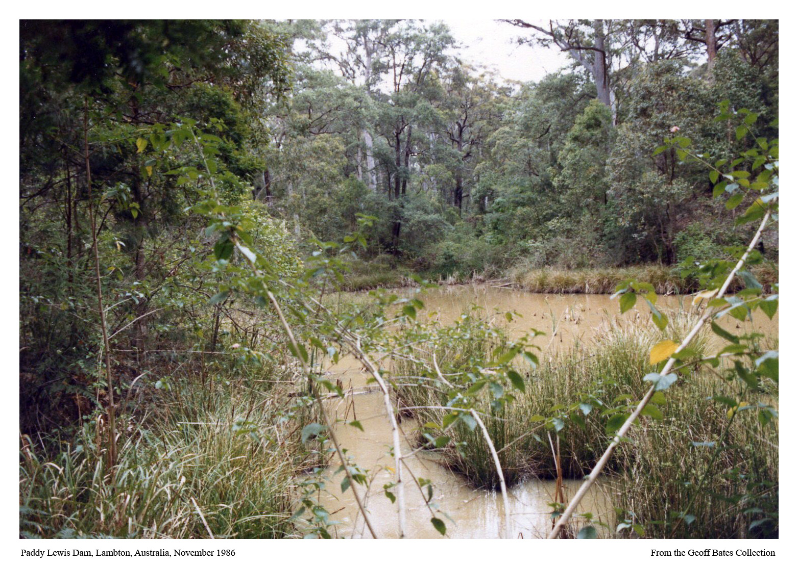

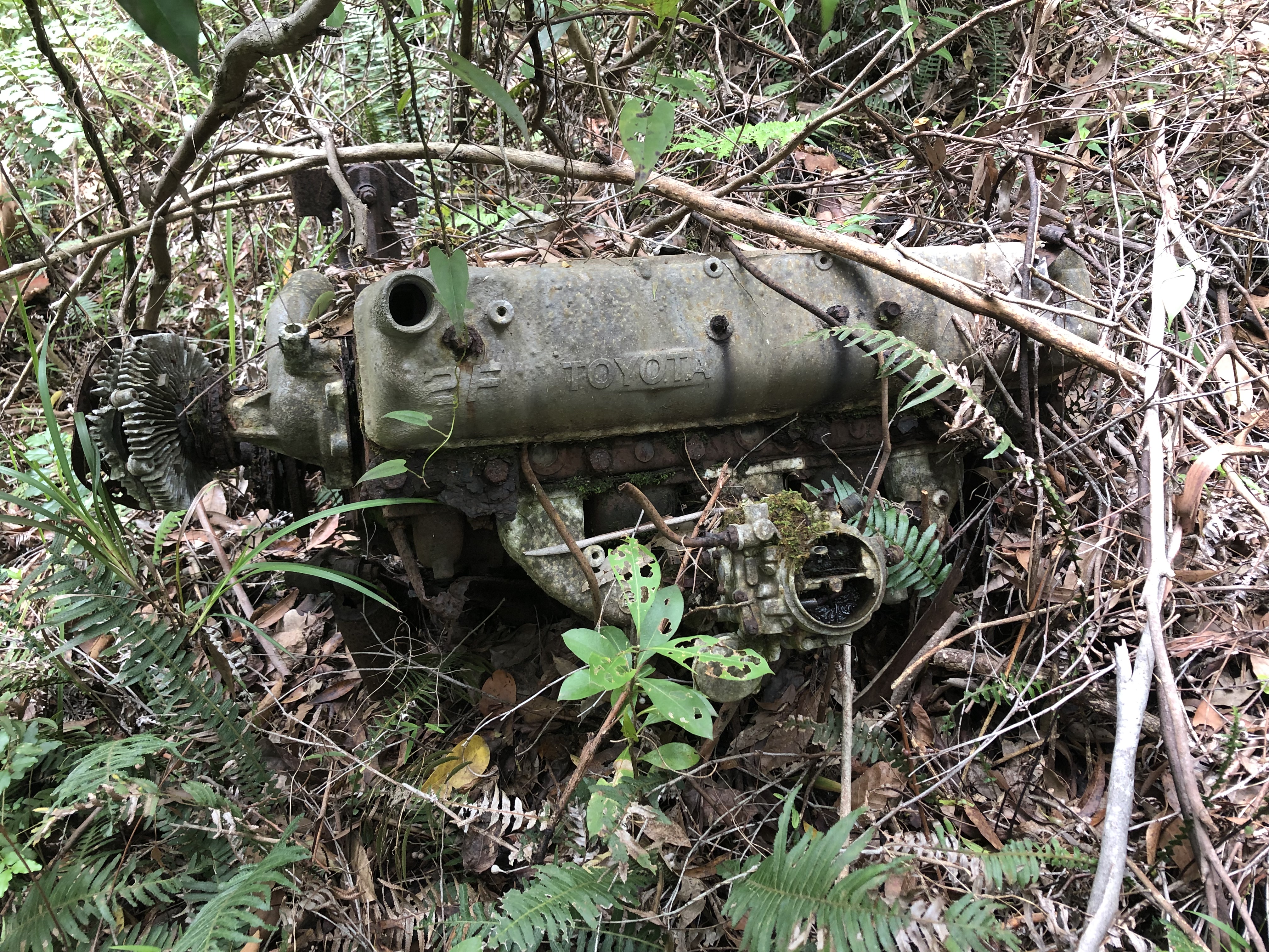
Geoff recalled that in 1986 he had to pick and choose where to photograph because of the old car bodies that had been dumped in the water of the dam. On a visit to Paddy Lewis in December 2018. I found the remains of a car engine in the bush.
| Article Date Event Date | Notes |
|---|---|
| 2 May 1876 | "For some time past a number of men have been employed by Mr. Croudace, Manager of the Lambton Colliery, excavating for the purpose of making a reservoir, in the bed of a creek, about half a mile from the pit, where it is proposed to erect an engine for the purpose of hauling the loaded skips from a portion of the dip workings." |
| 17 Nov 1904 16 Nov 1904 | Fire at the engine house known as Paddy Lewis’s. |
| 30 May 1921 | Dismantling the hauling engine known as Paddy Lewis in the western portion of the estate. |
| 14 Jul 1951 | Story of how a murder victim was thrown down a disused mine shaft in Jesmond. Allan Kemlo tells me that it wasn’t the Paddy Lewis shaft, but it shows the nefarious purposes that some of these old shafts were used for! |
I am reasonably convinced that the information, photos, maps, and locations described above refer to “Paddy Lewis Dam” which was also known as “Glen Lewis”. There is some evidence to suggest that this location was also known by the name of “Nellie’s Glen” or “Nelly’s Glen”.
However, there are some old newspaper articles, which suggest to me that there is another different location, in New Lambton, which was known as Nellie’s Glen. These articles refer to a location that also had a winding engine, but this engine was called “Die Davies”, and was dismantled in 1925.
The report of a January 1883 Lambton Council meeting notes that …
“the Improvement Committee had inspected the hills and found a suitable place for getting gravel, near the engine driven by Mr. Davies, on the [Lambton] company’s estate.”
This gives a clue as to the origin of the name of the engine, but not much towards its location.
I would welcome any information anyone has regarding this Nellie’s Glen and the engine that was once there.
In July 2019, I collaborated with Jacob Ure (Digging Australia YouTube Channel) to point him to potential sites to search with his metal detector. What he found was pretty exciting and included
My thanks to the following people/organisations for their contributions to this quest:
At the end of last year I came across this Ralph Snowball photo of New Lambton in the Ralph Snowball collection in the University of Newcastle Cultural Collections. Because of the damage to the negative, it took me a while to realise that it was not one photo, but two exposures of the same scene. Recently, Robert Watson pointed out to me that the photo is actually a stereoscopic (3D) image.
So with the instructions from a helpful video on Youtube, and using $5 pair of 3.0 magnification reading glasses from a local discount shop plus a small bolt, I was able to make some viewing glasses, and see some of our local history in 3D.

It took me a while to master the technique of getting the 3D effect. I found I got best results when I printed the photos out so that the left and right images were each 7cm wide. I discovered that that I had to cut the two exposures out and swap the images over (the left hand side of the original image was actually the right image, and vice versa). I found that I could achieve the 3D view best if I placed the images on a well lit horizontal surface with a gap of a few centimetres between the images, and then with the glasses close to my nose, use my left eye to focus on the left hand image, and then slowly move the right image in towards the left image until I got the two images to superimpose.
As well as the photo above that got me started on the 3D viewing exercise, I have subsequently found five other stereoscopic images in the Ralph Snowball collection.

Note: I have used the content of this blog post for my August 2023 article for “The Local”.
As a recently arrived resident of Lambton with an interest in local history, I was aware that Lambton had its beginnings as a coal mining township. But where was the colliery? What, if anything, remained of it? It was only on finding some old photos in the University of Newcastle Cultural Collections that I was able to answer these questions.
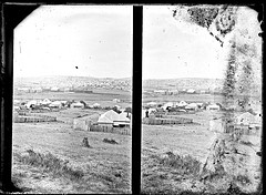
This Ralph Snowball photo from 1900 looking north from Russell Rd in New Lambton shows the colliery buildings nestling in the gully between Lambton and New Lambton, with the colliery railway going down the slope heading towards Broadmeadow.

Inspired by this and other photos in the University’s collection, I set myself the challenge during a two week Christmas break, of every day visiting the location of an historical photograph, and as far as possible replicating the original image. In the modern photo here, the Lambton colliery has disappeared. After opening in 1863 it closed 74 years later in 1936 and then slowly faded away – buildings demolished, equipment removed, pits filled in, new streets laid out, housing erected, rail lines ripped up, and the final disappearing act in 1966 when the rail bridges over Howe St and Hobart Rd were torn down.
The only visible evidence I could find of the colliery were shadowy remnants – the open space of Lewis oval, the slight dip in Hobart Rd and the funny little jink in Howe St where the railway bridges once were, a drain culvert at the western end of New Lambton Park, over which the railway once ran.
In coming months I’ll share some other “Then and Now” comparisons. As a newcomer to the area and its history, I’d welcome your feedback or further information. You can do that by leaving a comment on any of the pages in this site.

The article above was first published in the February 2015 edition of the Lambton Local.
| Article Date Event Date | Notes |
|---|---|
| 19 May 1863 14 May 1863 | Blasting accident at Lambton Colliery. Thomas Croudace and Mr. M'Avery suffering eye injuries. |
| 30 Dec 1863 26 Dec 1863 | A public dinner for 120 workmen and employees of Lambton Colliery to celebrate the completion of the railway and the opening of the mine. |
| 20 Jun 1936 | Closure of Lambton Colliery after 74 years of operation. Note that this article has a number of factual errors. It says that the first deaths in the mine occurred in 1878, it was actually 1864, and that one of the men killed was Mr Morehead, it was actually Mr Seymour, who was acting as mine manager in Thomas Croudace's absence. |
As a recently arrived resident of Lambton (coming all the way from North Lambton), I was aware that Lambton had its beginnings as a mining township. But where was the colliery? What remained of it?
When a strangler fig envelopes and outlives the tree that originally supported and strengthened it, the original tree decays away into nothingness, and the once strong tree is then only defined by what is not there, by the tree shaped void in the heart of the fig. Lambton colliery is like that. Opened in 1863, it closed 74 years later in 1936 and slowly faded away – buildings demolished, equipment removed, pits filled in, new streets laid out, housing erected, rail lines ripped up, and rail bridges torn down – the last disappearing act in 1966. Lambton colliery is discernible now only in shadowy remnants – the open space of Lewis oval where the colliery once stood, the slight dip in Hobart Rd where the old tramway passed under the colliery railway, the funny little jink in Howe St where the road veered to pass through the narrow gap of the railway bridge.
The only physical evidence of the colliery I could find was this culvert, at the western end of New Lambton Park, over which the colliery railway once ran.
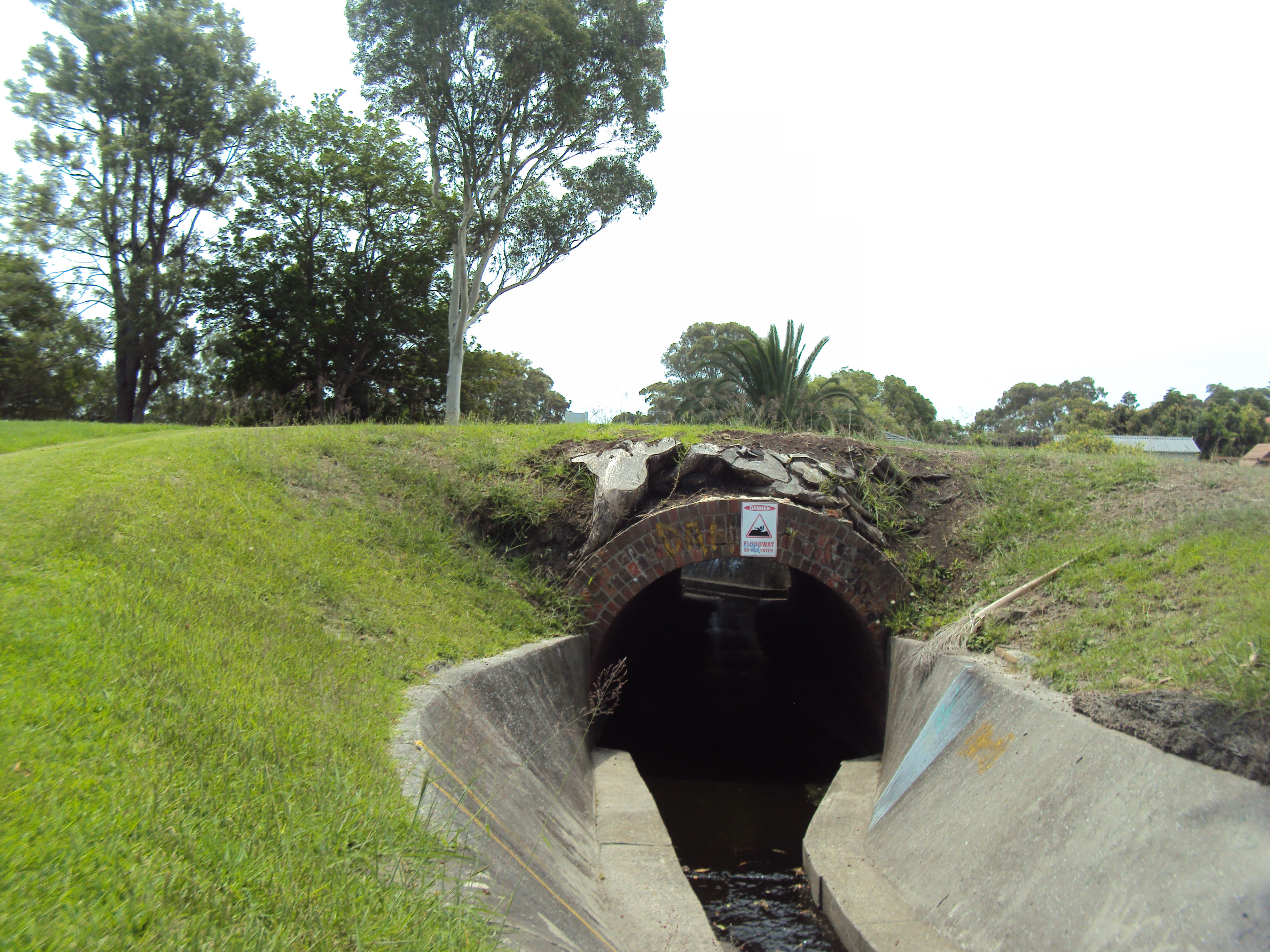
Culvert over which the Lambton colliery railway formerly ran.
With so little of Lambton’s colliery origin still visible, I began to think about what has changed and what has stayed the same in Lambton over the last 150 years. So with a two week break over Christmas from my usual employment, I set myself the challenge of every day visiting the location of an historical photograph, and as far as possible, replicating the original image. To exercise my body as well as brain, I added the constraint that the location had to be reached from my home by walking or riding a bike. The result was this series of 16 “Then and Now” photographic comparisons.
Some of the comparisons were striking in what has stayed the same – the rotunda in the park, the Council Chambers/branch library, Lambton Lodge (the home of Thomas Croudace the colliery manager), while other comparisons highlighted vast change – most notably a cricket pitch now laid out where men and boys once entered the earth to labour in the underground coal seams.
Although the colliery is now gone, the Lambton community that grew around it has survived and matured, a lasting legacy of coal mining origins.
Two final thoughts, as I think about the changes in Lambton over the last century and a half:
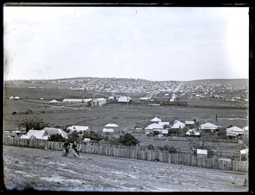
Lambton colliery and Lambton township, looking north from Russell Rd, New Lambton. Photo by Ralph Snowball. University of Newcastle Cultural Collections.
On the North Lambton hill in the background, three streets are visible going up the hill – on the left hand side is Dent St, on the right hand side is Morehead St, and the thinner shorter street in the middle is Grainger St.
In the modern photo, Dent St and Grainger St are hidden by houses and trees, but Morehead St is still visble.

Lambton Colliery. Photo by Ralph Snowball. University of Newcastle Cultural Collections.
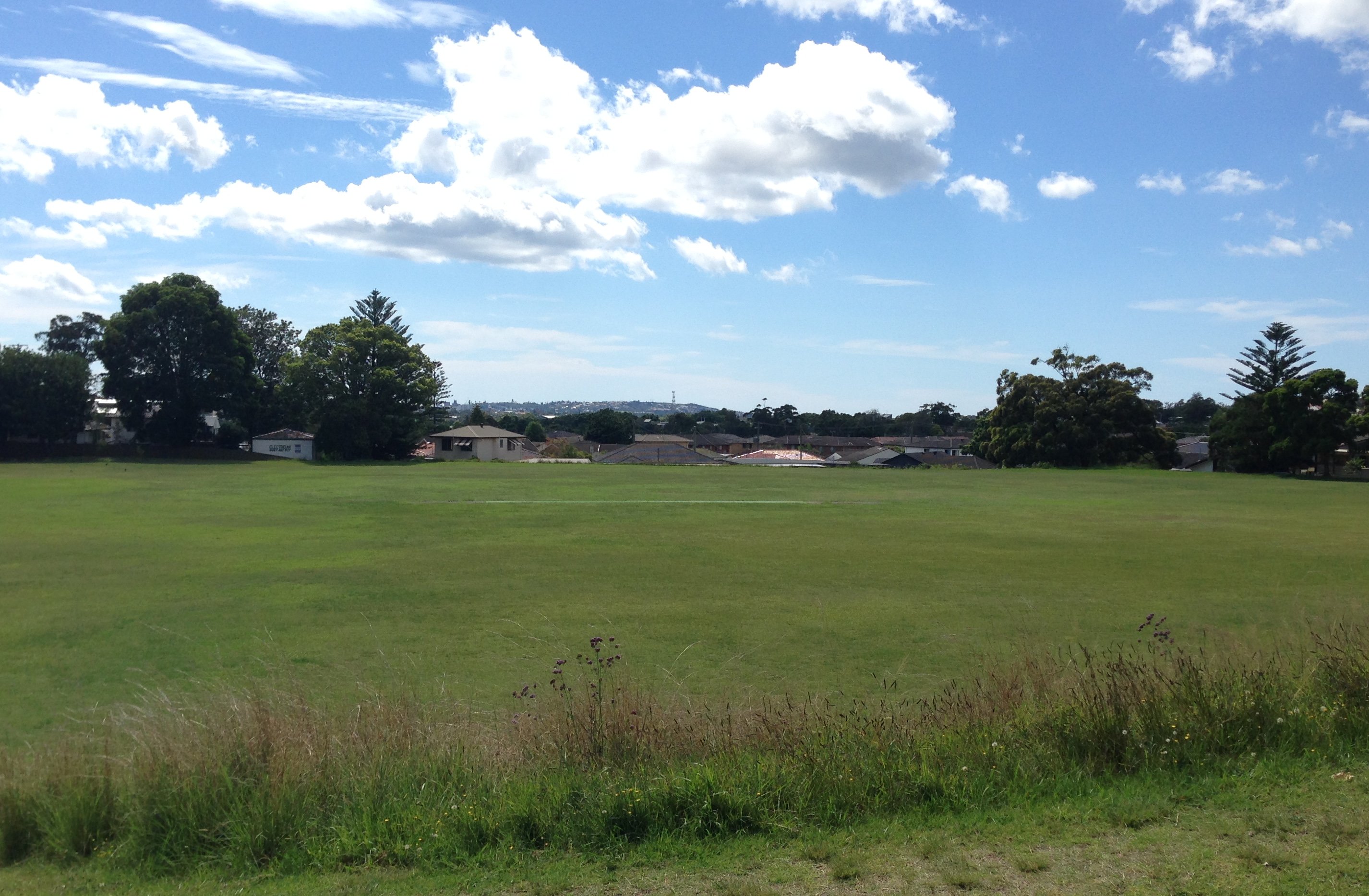
Lewis Oval, New Lambton. Site of the former Lambton Colliery,.
Most of the photos in this “Then and Now” series highlight similarities – things that have remained relatively unchanged through the course of years. Today’s photos highlight difference. The site of the former Lambton colliery has been radically changed with the removal of all the colliery infrastructure and earthworks to create a sporting oval and behind the oval new housing subdivisions. The only point of similarity between the two photos is the outline of Sheperds Hill in the distance, on the horizon.
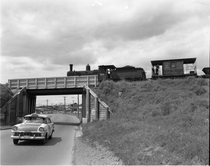
Railway bridge over Hobart Rd New Lambton. The railway led to the Lambton Colliery site a few hundred metres to the west of this location. Hunter Photo Bank. Newcastle Region Library.
The railway bridges over Hobart Rd and Howe St were removed in 1966. The only subtle reminders that remain, are the slight dip in Hobart Road where it passed under the bridge, and a funny little jink in Howe St where the road needed to pass perpendicular under the narrow bridge.