The Scottish Australian Mining Company, owner of the Lambton colliery, was pivotal in the establishment of three of Newcastle’s finest recreation reserves – Lambton Park, Blackbutt Reserve, and Jesmond Park.
Although not officially dedicated until 1924, the Jesmond Park site had a long history of recreational use. From Lambton’s earliest days, this low-lying area at the northern extremity of the company’s mining lease, with Dark Creek running through it, was used for competitive pigeon shooting. It soon also became a popular picnic site, known as “Croudace’s Paddock” presumably because the permission of Thomas Croudace, the colliery manager, was needed to use the area.
Churches, schools, and community groups regularly held picnics there, sometimes with hundreds of attendees. The site was within easy walking distance from Lambton, North Lambton and Jesmond. It became even more accessible when the Newcastle to Wallsend tramway was constructed in 1887. Around this time, the idyllic bushland nature of the picnic site was altered somewhat with the establishment of Campion’s soap and tallow works adjacent to Dark Creek.
As early as 1908, Lambton Council and local residents began petitioning the Lands Department to have the area formally set aside as a public park. Their efforts were rewarded in 1923, when Frederick Croudace (son of Thomas) as manager of the colliery, gifted to the council the 22 acres of land that become Jesmond Park.
The area known as Croudace’s Paddock was larger than just the Jesmond park site, but encompassed much of the flat area adjacent to Dark Creek. A 1904 article describes the seven acre sanitary depot as being in Croudace’s Paddock. The sanitary depot was located where the Skyline drive-in theatre would later be constructed, and where Drysdale Drive and Rees Way is today.
A November 1938 article on the park noted that the “portion of the park now used as a recreation area was once a cultivation paddock. On it fodder was grown for the mine horses. The land flattened out with the passing years; signs of plough furrows disappeared and a cricket oval was formed.”
“Jesmond Park, showing the trees in profuse foliage and forming a delightful rural scene – approximately four miles from the ocean beaches.” Newcastle Morning Herald, 16 Dec 1933.
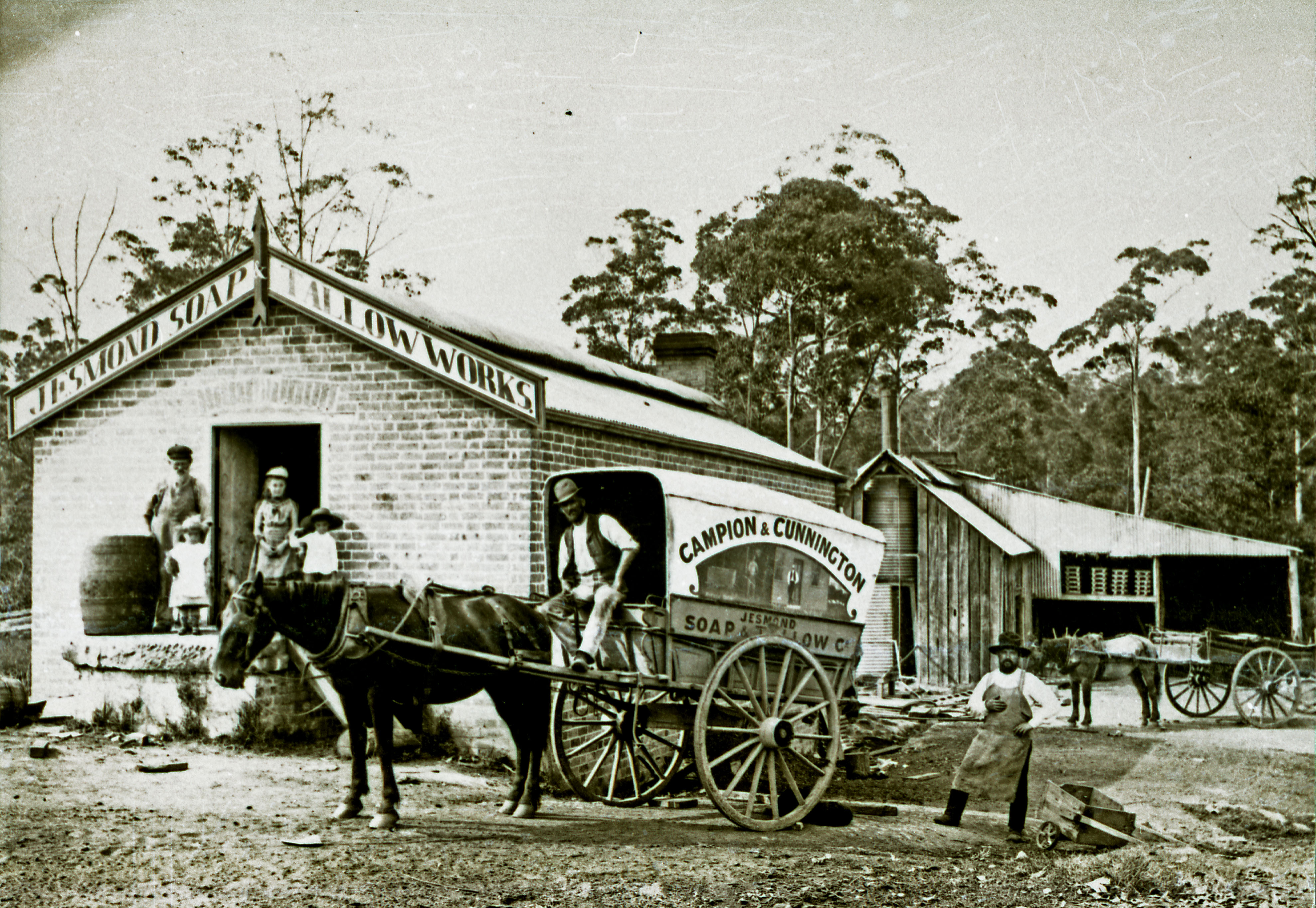
Campion’s Soap and Tallow Works
According to the Jesmond Public School 1887-1987 Centenary booklet, John Campion arrived in Australia from England c1880. Around 1887 Campion began refining tallow for miner’s lamps, in partnership with his brother-in-law Ben Cunnington. The photo below, from the University of Newcastle Cultural Collections, shows Campion & Cunnington’s Soap and Tallow Works in 1892.
Campion and Cunnington’s Soap and Tallow Works, Jesmond, NSW, February 1892. Photo by Ralph Snowball. University of Newcastle Cultural Collections.
The nature of soap manufacture meant that the works were susceptible to fire, and a number of incidents of destructive fires were recorded over the years.
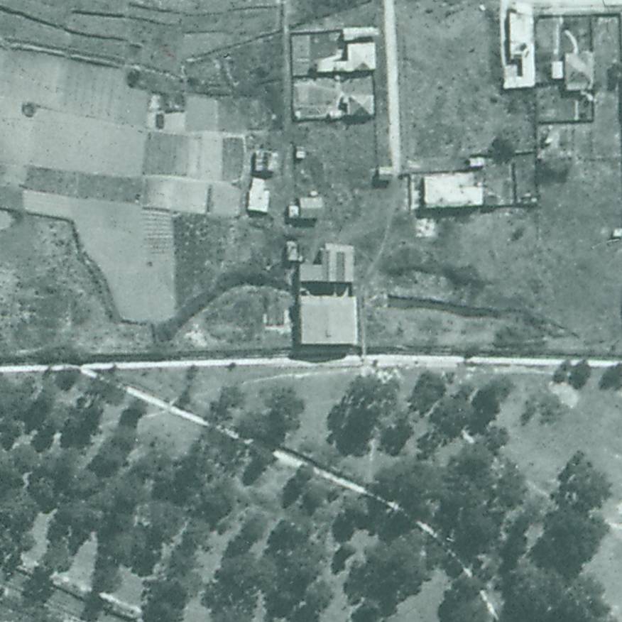
A 1944 aerial photograph shows the soap works building sitting astride the remnants of Dark Creek, just to the north of the concrete storm water drain. Just to the east of the building is the dam that appears in the 1934 newspaper photograph.
Campion’s Soap and Tallow Works in 1944.
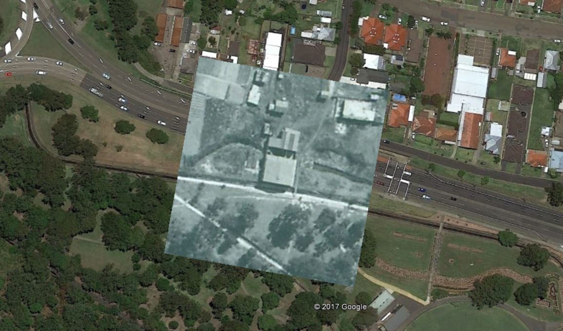
1944 aerial photograph overlay in Google Earth, showing location of Campion’s Soap Works, Jesmond NSW.
First mention of "Croudace's Paddock" in the newspaper. Inquest into the accidental shooting death of a young lad, Charles Blim, after a pigeon shooting match.
"A grand pigeon shooting match is to come off between two old knights of the trigger, in Mr. Croudace's paddock, at Dark Creek, on Saturday (three weeks) between Blacket Richardson and John Ferguson, for £10 aside."
Remarks on the naming of Dark Creek … "Jesmond is the correct, and more suitable name of this locality. It derives its title of Dark Creek from the men and days of thirty years ago, when the place was remarkable for its thickly, woody, and consequently shaded appearance."
Advertisement for the Lambton Primitive Methodist Sunday School picnic in Croudace's Paddock, advising that "the Traffic Manager having been written to, the trams will probably stop at the paddock."
"The members of the Wallsend and Lambton Government ambulance classes assembled in Croudace's Paddock, Lambton, on Saturday, and were examined in squads by Drs. Nash and Stapleton as to their knowledge of the principles of rendering first aid to the injured."
"The Newcastle, Lambton, and Wallsend companies of the 4th Infantry Regiment went into camp at Croudace's Paddock, Jesmond, last night, while it was raining heavily. It is intended to "take" Charlestown this morning."
"Croudace paddock is fast getting into favour as a holiday resort. There were no less than five parties of picnicers on the ground and the immediate vicinity yesterday."
Jesmond Progress Committee asks Lambton Council "to approach the general manager of the S.A.M. Company, with a view of getting a grant of the land known as Croudace's paddock as a public park for Jesmond."
The tramways department asks Lambton Council to suggest a name for the stopping place near Croudace's paddock. The Council recommends the name "Charlton", however there is no evidence that this name was ever adopted.
Lambton Council asks the Lands Department to resume Croudace's paddock, Jesmond, for a recreation reserve. Alderman Bell said that "for many years the area, by permission of the S.A.M. Company, had been largely availed of for picnic purposes, and as a ground for cricket and football. The situation was on ideal one, and with very little expense it could be converted into one of the best parks in the district."
Alderman Hardy, Mayor of Lambton, raises with the Minister of Lands the question of resuming an area of land at Jesmond, known as Croudace's paddock,
for a park. "The Minister assured the Mayor that this matter had not been overlooked. The papers had been referred to the district surveyor."
Frederick Croudace, meets with the district surveyor and a representative of the council to inspect the land known as Croudace's Paddock, for the proposed park at Jesmond.
"The matter of the acquisition of an area approximating 22 acres of land at Jesmond had been brought to a successful conclusion by an interview with Mr. Robinson, general manager of the Scottish Australian Mining Company, who agreed to grant the land to the council for park purposes, the only obligation on the part of the council will be the survey transfer and fencing costs. The thanks of the council were due to Mr. Robinson and Mr. Croudace for the fairness and courtesy shown during the negotiations and to the company for its generous gift."
"A. Barrie, on behalf of Jesmond Cricket Club, asked Lambton council last night for permission to lay a wicket on Jesmond park. The Mayor said that the application was premature, as the council did not yet have control of the park. It was resolved to refer the matter to the Scottish Australian Mining Com
pany."
"The S.A.M. Company had dedicated to the municipality Croudace's paddock as a public park. Efforts were made to obtain a grant from the Government to improve the area, but so far without any good result."
"A petition was received from the residents of Jesmond, bearing 42 signatures, asking that the Jesmond loop be retained as a tram stopping place in addition to the new stop at Steel-street."
"Some time ago the Jesmond Progress Association approached the council with a view of having a water service connected to the Jesmond Park. They offered to carry out the work providing the council would bear the cost of the material … Voluntary labour was forthcoming to dig and cover in the trenches, the whole of the work being completed during the week. The [water] board granted a free supply of water on
the condition that it would be used for drinking purposes only."
"Within a four-penny-tram ride of the city is Jesmond Park - a natural playground which has been saved for posterity by a council now extinct. Practically unknown by many people, the park provides ample facilities for sporting activities amid the quiet surroundings of the silent bush."
A motion is defeated in Newcastle Council that would have seen Jesmond Park renamed to Johnson Park, in honour of Alderman J.T. Johnson, who served on Lambton Council for many years.
Blackbutt Reserve today owes its existence to a strange combination of business prosperity, national adversity, and private tenacity.
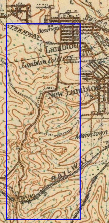
The current area of the Reserve lies wholly within the boundaries of a coal mining lease of the Scottish Australian Mining Company. The eighteen hundred acre lease extended from Kotara South to Jesmond. Mining commenced in 1863, and apart from occasional downturns, the colliery prospered. Therefore, above ground there was little development apart from buildings such as pumping stations, required to support underground mining operations.
However, with the depletion of coal, and rising land taxes, the S.A.M Company looked for other income, from real estate. Between 1915 and 1928 the company developed and sold a few small subdivisions in Lambton, New Lambton, and Kotara. In June 1932, they attempted to auction a large parcel of land, in what is now the southern part of Blackbutt Reserve. The nation at this time however, was suffering the adversity of economic depression. There was little appetite for land purchases, and only five of the 52 lots on offer were sold. The failure of the auction thus left open a window of opportunity for local councils to purchase the land for a nature reserve, starting with 17 acres on Lookout Road in 1938, and increasing to 144 acres by 1940.
In 1956, Newcastle Council bought another 270 acres from the S.A.M. Company, in what is now the northern part of Blackbutt Reserve. Council wanted to subdivide all this land for housing, but through the tenacious opposition of private citizens and community groups, this development was blocked. Instead, the land was added to Blackbutt Reserve. Community opposition had to swing into action again in 1966 to prevent the Department of Main Roads building an expressway through the Reserve.
Many individuals worked tirelessly for the establishment and preservation of Blackbutt Reserve. One in particular, Joe Richley, president of the Northern Parks and Playgrounds Movement for 20 years, is commemorated in the name of Richley Reserve.
The approximate site of Middle Pit in 2017, at the entrance to Richley Reserve.
The article above was first published in the July 2017 edition of the Lambton & New Lambton Local.
Acknowledgement
One of my main sources in researching and writing this article was “A History of Blackbutt Nature Reserve” by John Ramsland, University of Newcastle, a manuscript written for the Blackbutt Reserve Local Committee as a contribution to the Australian Bicentennial Celebrations. A copy of this manuscript is held in Newcastle Region Library Local Studies Section, Q719.32/RAM.
Two views of Blackbutt Reserve, which is being acquired by the municipal councils of the district for retention as a public park. From the shelter shed there is a commanding view of Newcastle.
Newcastle Morning Herald. 12 Jan 1937.
Newcastle Morning Herald. 12 Jan 1937.
Development on the S.A.M. Co Mining Lease
The 1888 map below, held by the NSW Land and Property Information, shows the 1840 acres of mining lease held by the Scottish Australian Mining Company in the name of “Morehead & Young”, in the following lots:
Lot 23 – 320 acres
Lot 167 – 320 acres
Lot 171 – 320 acres
Lot 172 – 240 acres
Lot 173 – 320 acres
Lot 174 – 320 acres
1888 map showing mining leases of Scottish Australian Mining Company. NSW Land and Property Information.
Fifty years after mining commenced in 1863, a 1913 War Office map shows that the only area of the 1840 acre mining lease with residential development is the township of Lambton in the north west corner.
Portion of 1913 War Office map of Newcastle, with 1840 S.A.M. lease outlined in blue. National Library of Australia.
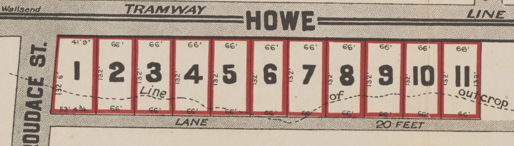
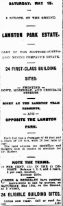
From 1915, the Scottish Australian Mining Company started developing and selling residential subdivisions, starting with 24 blocks of “Lambton Park Estate” fronting Howe St, in May 1915.
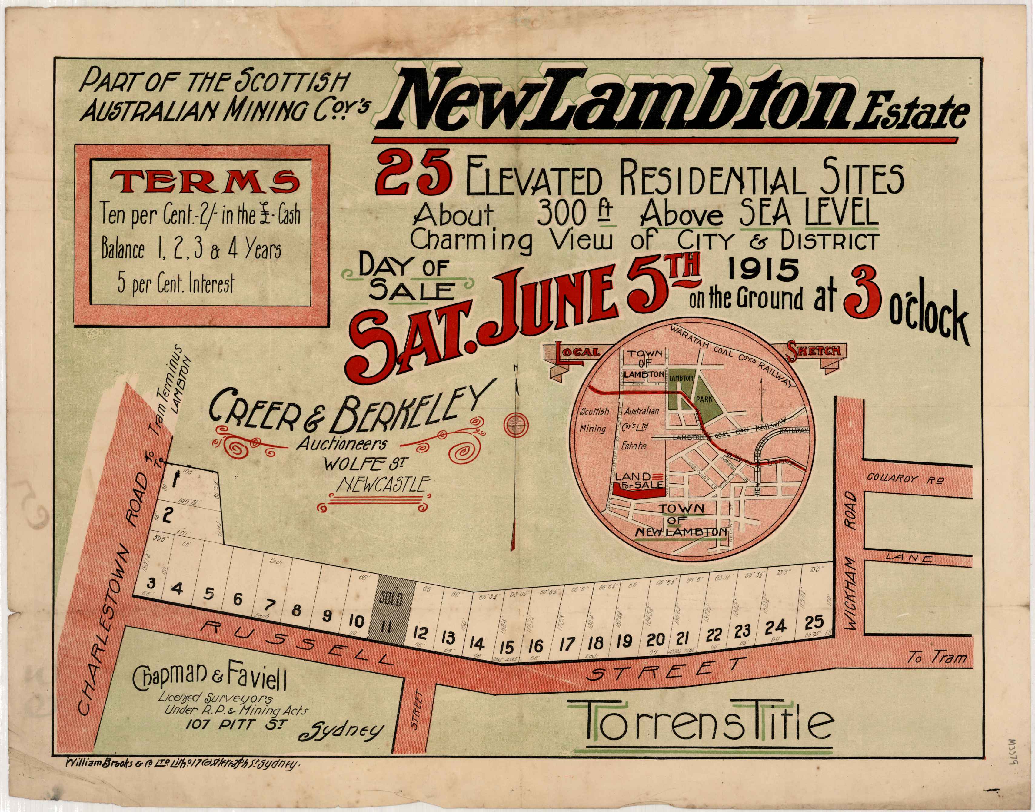
Twenty five blocks on Russell St New Lambton were offered for sale in June 1915. (All real estate posters are from the University of Newcastle, Cultural Collections.)
Fifty seven blocks surrounding Chilcott St Lambton were offered for sale in January 1920.
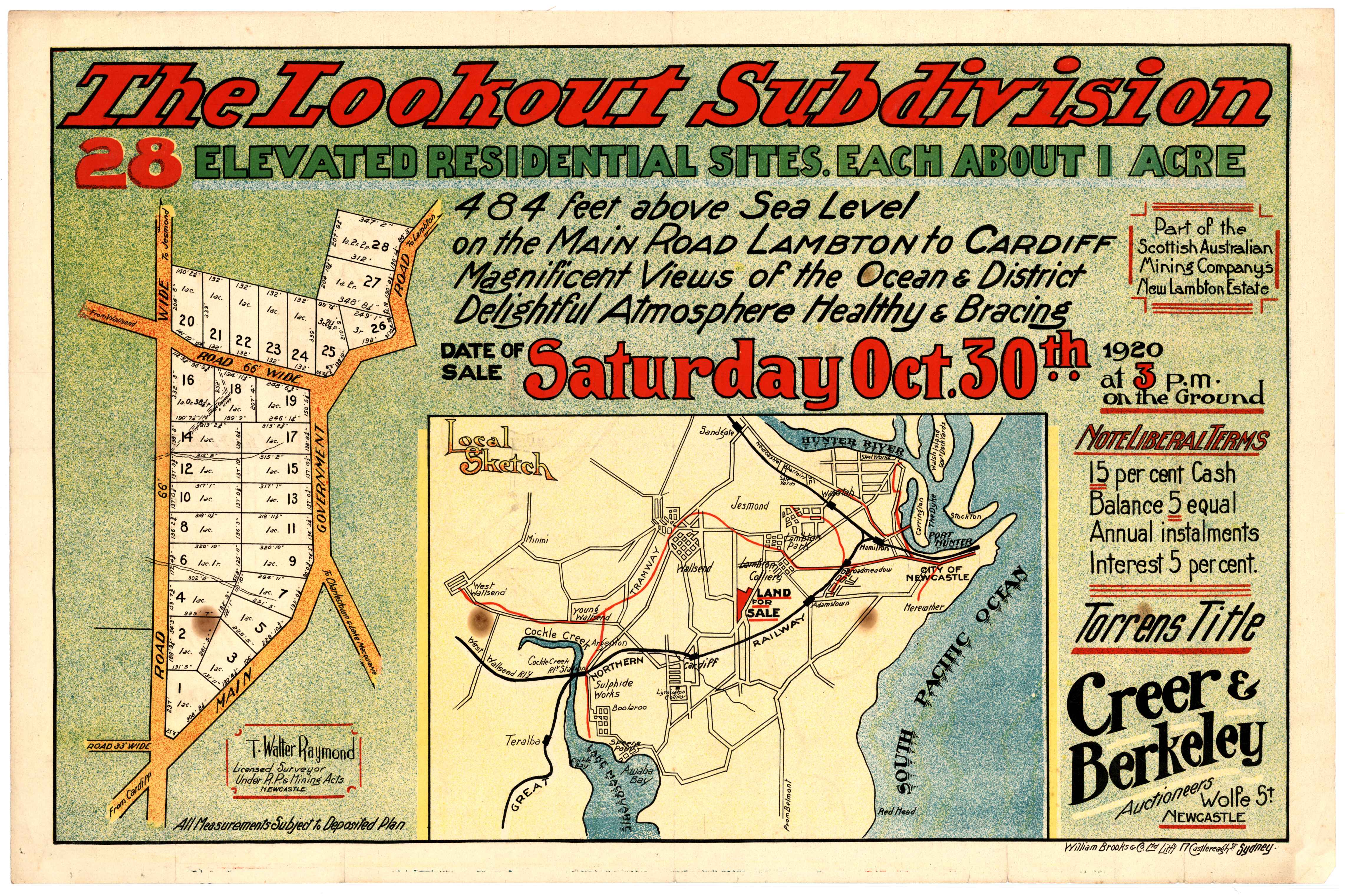
Twenty eight blocks in New Lambton Heights were offered for sale in October 1920.Ten blocks on Curzon St and Carrington Pde, New Lambton were offered for sale in December 1921.
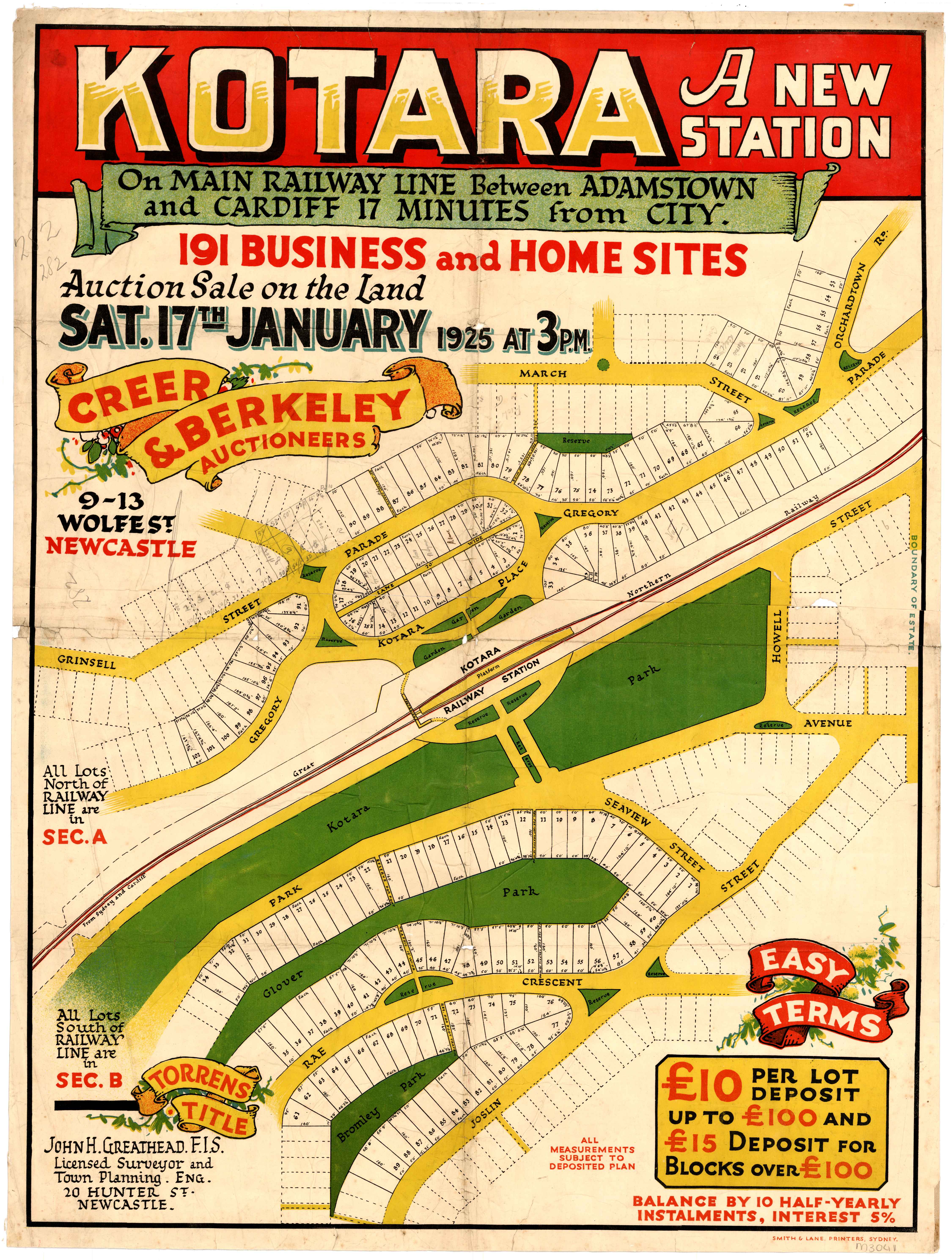
191 blocks in Kotara were offered for sale in 1925.
Twenty six blocks on Turner St Lambton were offered for sale in 1928.
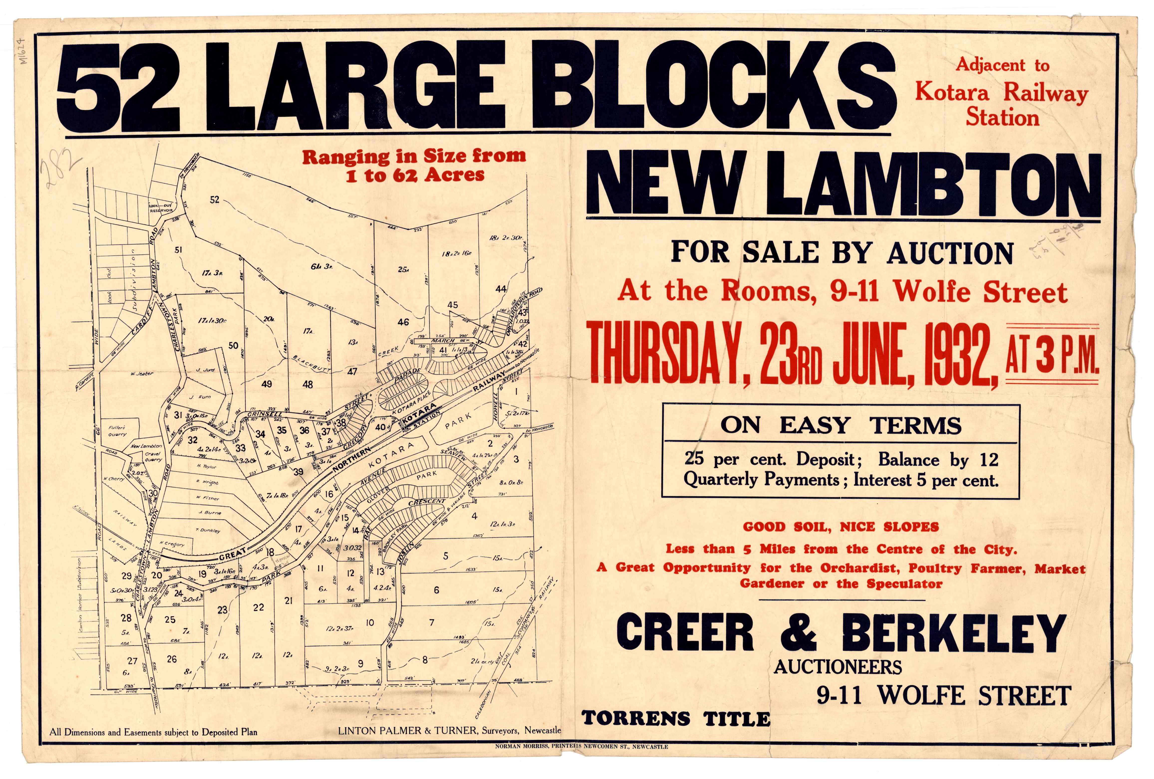
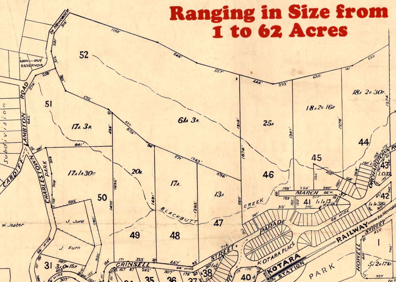
In 1932, the Scottish Australian Mining Company attempted to auction 52 blocks of land, totalling 480 acres. With the country in the grip of the Depression, the auction was a failure, with just five of the 52 blocks selling.
Poster for auction of land in Blackbutt Reserve area, 1932. University of Newcastle, Cultural Collections.
One of the blocks that sold was Lot 51, on Lookout Rd. This was bought by the Newcastle Branch of the Returned Sailors and Soldiers Memorial Institute. It was this block that became the first officially gazetted portion of Blackbutt Reserve in March 1938.
The 17 acres and 3 roods of Lot 51 on Lookout Road, was the first portion of Blackbutt Reserve to be officially gazetted. University of Newcastle, Cultural Collections.
By September 1940, the size of Blackbutt Reserve had been increased to 144 acres, as shown on this Parish Map of Newcastle. The 144 acres consisted of Lots 48 to 52, and part of lot 47 of the 1932 subdivision.
Parish map of Newcastlem showing the boundary of the 144 acres of Blackbutt Reserve as of 13th September 1940. University of Newcastle, Cultural Collections.
It is interesting to see how the modern boundaries of Blackbutt Reserve fall entirely within the S.A.M. Company’s mining lease, an indication of how the underground mining activities there in the 19th century left large areas of the surface undeveloped, and available for a nature reserve in the 20th century.
Blackbutt Reserve in relation to the S.A.M. Company mining lease.
Middle Pit
The first reference in Trove to the Middle Pit is from January 1875, in relation to driving “two narrow bords four yards wide for water standage.”
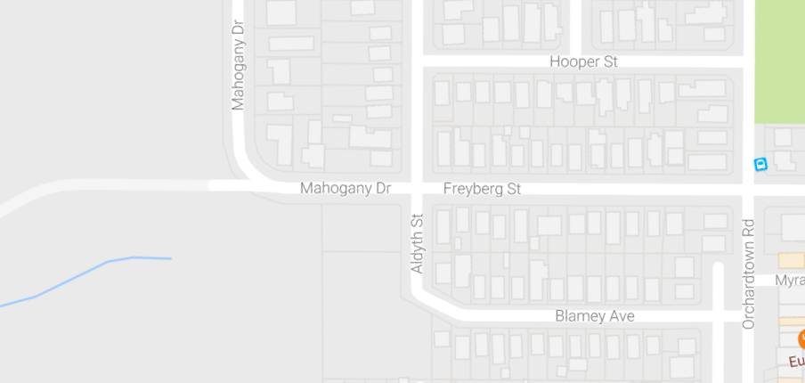
It is uncertain when the Middle Pit pumping shaft ceased operation. It was still in use in June 1913, as an article refers to the damage done to Orchardtown Road in the course of carting coal to Middle Pit, presumably to fire the engine boilers. A December 1937 article reported on the attempted rescue of a dog that had purportedly fallen down the shaft. The site had obviously been unused for quite a number of years, judging by the description …
The disused shaft is known in the locality as Middle Pit, and was formerly used in connection with the workings of the Old Lambton mine. Pit top gear, including an old rusted winding wheel, is still there, but the pit itself has fallen into disuse. It is in a deep gully, and nobody would suspect its presence when more than 100 yards away. Thick lantana has grown almost to the edge; briar bushes form a barrier between the outside world and the old shaft. The only sound is the sighing of wind in the gum trees. In the interests of safety the shaft has been enclosed by a tall galvanised iron fence. The ground at the foot of portion of the fencing has worn away, and through this hole the dog probably slipped in.
In this 1944 aerial photo the location of Middle Pit can be seen in the bare area to the west of Freyberg St. Newcastle Region Library.
Thirty to forty aldermen of the city and district inspect the Blackbutt area. The Mayor of Newcastle (Ald Parker said that they "were definitely impressed that if acquired for a reserve it would be an asset to the district."
"An area of 17¾ acres in Blackbutt Reserve imnmediately below the Look-out, has been bought by the Returned Sailors and Soldiers' Memorial Institute. The purchase will serve a dual purpose, for not only will returned men willing to work for any relief they may obtain from the Institute carry out their undertaking there, but the Institute will settle a few ex-service men there on small allotments."
This block became the first official part of Blackbutt Reserve in 1938.
Convinced that Blackbutt Reserve is inappropriately named, the Mayor of Newcastle (Ald. H. Fenton), in his capacity of Chairman of the Local Govern
ment Coordination Committee, is urging the adoption of a more attractive title. He suggested last night that if the reserve was dedicated as a memorial to King George V., it could be called the "King George V Memorial Park." Or there might he support, Ald. Fenton added, for a proposal that the area be
known as the "Duke of Windsor Reserve."
A public meeting will be held to protest against the Main Roads Board decision to route a six-lane highway through Blackbutt Reserve.
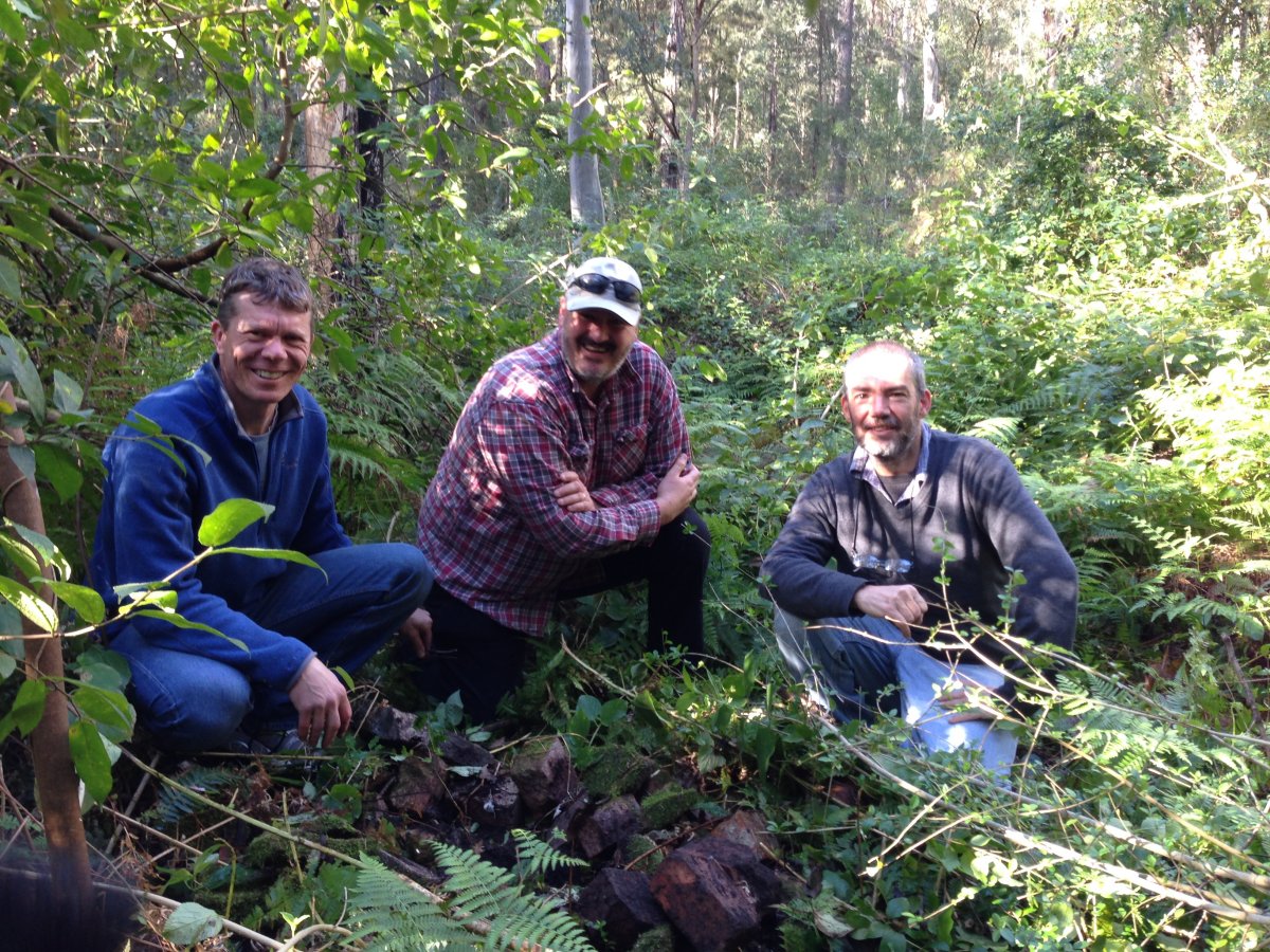
A few hundred metres from the site of Middle Pit, in the bush adjacent to Richley Reserve, lies this rusting coal bucket, a poignant symbol of the way in which the decline of coal mining gave rise to a nature reserve.
Rusting remains of a coal bucket, lying in the bush close to Richley Reserve.
The growth of our city means that former collieries are eventually obliterated by urban development, and it becomes difficult to find any trace of their former existence. Sometimes however, evidence of the old mines can be found, quite literally, under our feet.
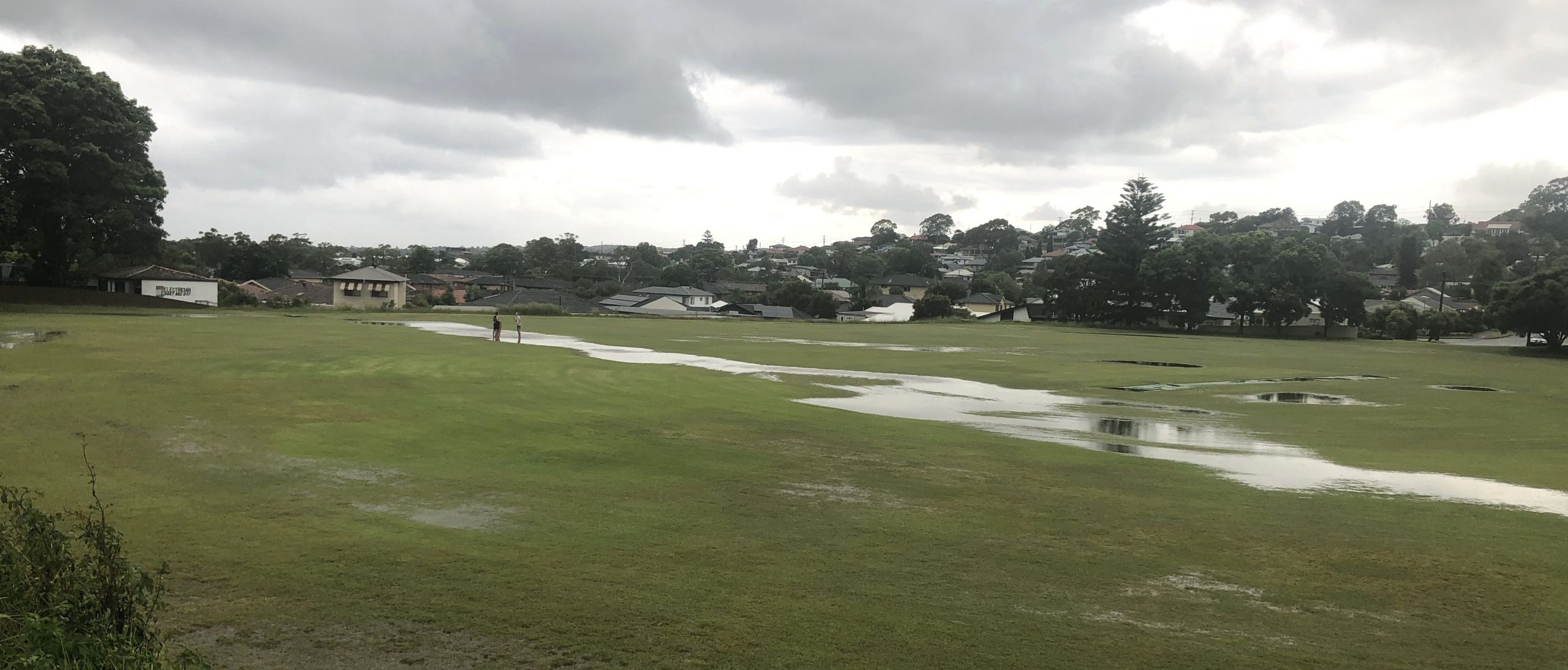
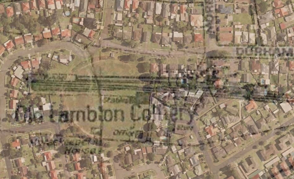
Last year I was walking over Lewis Oval in New Lambton at dusk, when I noticed a slight dip in the level of the ground. I wondered, could this possibly be due to subsidence related to the former Lambton colliery?
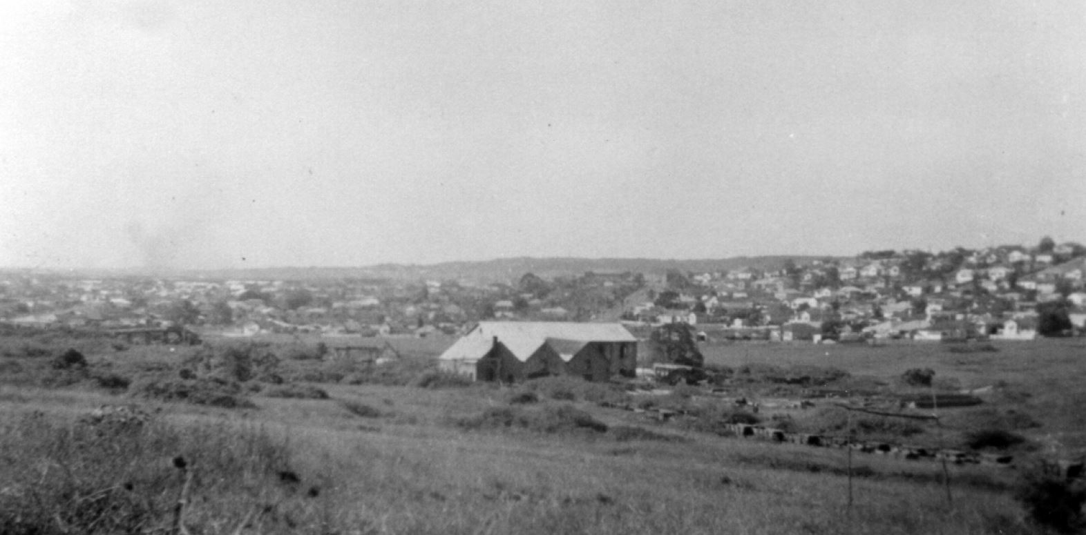
A September 1944 aerial photograph held by Newcastle Library shows that the mine was located at this site. The mine closed in 1936 and much of the surface infrastructure was removed by 1944. The large double storey building in the centre of the photograph housed the colliery’s machinery workshop on the lower floor, and a sawmilling plant on the upper floor. The building got a new lease of life in 1947 when Leonora Glass Industries began operations there.
The railway also continued to be used after the mine’s closure, as noted in a 1942 newspaper article,
“Coal was being hauled by motor-trucks from Cardiff for loading onto the coal waggons near the site of the old colliery screens.”
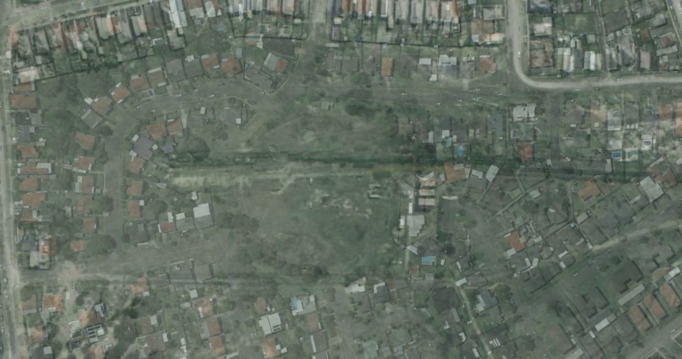
Carting of coal from the site ceased in 1963, the area was developed for housing, and Lewis Oval constructed over the filled in railway cutting. Sixty years on, a slight subsidence of the railway in-fill causes water to collect in the depression. In the right conditions, the grass grows slightly greener, and in some of the modern Google Earth photos, the position of the old railway can still be discerned in a green horizontal line just north of the cricket pitch.
So if you ever find yourself defending the boundary at Lewis Oval, and you notice the outfield seems a little bumpy, you might just be experiencing an enduring impression of our coal mining history.
The Lambton Colliery site in September 1944. Newcastle Region Library.
The Lambton colliery site in 2016. The path of the former rail line can be faintly seen running across Lewis Oval. Google Earth.
The article above was first published in the April 2017 edition of the Lambton & New Lambton Local.
Additional Photos
In this 2006 Google Earth photo, there is a quite distinct darker green line running across Lewis Oval. Google Earth.
Subsidence of Lewis Oval along the line of the former rail excavation revealed after torrential rain, February 2020.
The line of the former railway excavation is revealed again after heavy rain in February 2022.
Lambton Colliery. 1913-1920. The Story of Lambton. From the collection of Dorothy Jones.
The photo above can be dated by the chimney stacks in the distance. The stack of the brickworks at Waratah which was constructed in 1913 is visible, and we can also see the stack of the copper smelter at Broadmeadow, which was demolished by 1920.
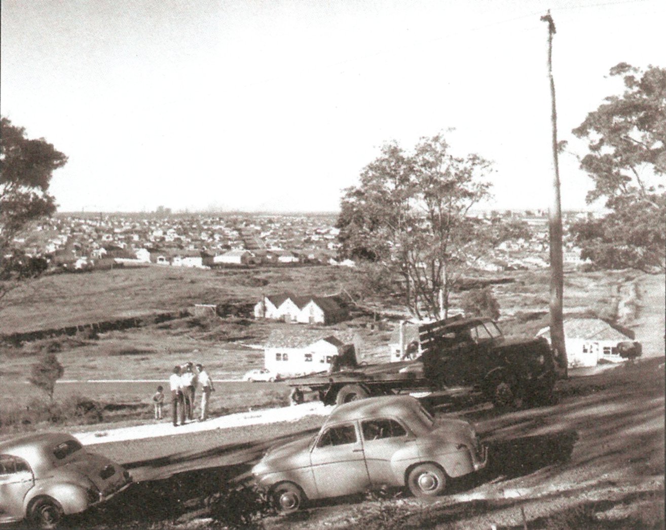
Lambton colliery site, 1951. From the collection of Albert Bates
Lambton Colliery site 1959. The large double storey building where the Leonora Glass Works operated is now gone, destroyed by fire in 1957. The Story of Lambton, p. 19. Photo from Stuart Thompson
Additional information
My blog post from February 2016 when I first discovered subsidences in Lewis Oval, marking the path of the former rail line.
If you have Google Earth installed, you can view the 1944 aerial photograph as an overlay by opening this Lambton Colliery (1944 aerial).kmz file.
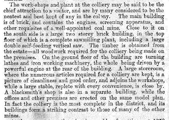
A description of the large double storey building at the Lambton colliery in 1890 can be found on page 15 of “The Coal Mines of Newcastle” by George H. Kingswell. This book has been scanned by the University of Newcastle Cultural Collections.
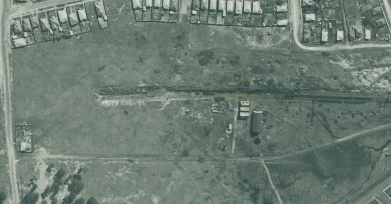
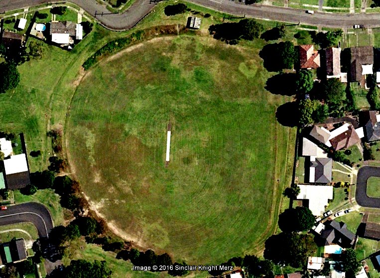
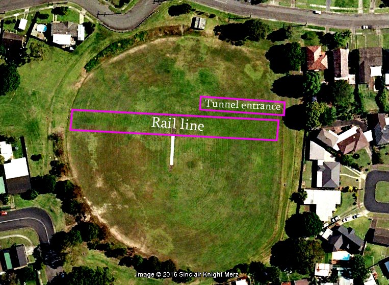
In a previous article I wrote about finding parch marks in Lewis Oval, and suggested that they were due to the railway cutting and tunnel of the former Lambton Colliery. I recently obtained a scan of a 1944 aerial photograph of Lambton from the Local Studies section of Newcastle Library. By overlaying the photograph in Google Earth I can see that my guess was spot on.
The former Lambton Colliery, September 1944.
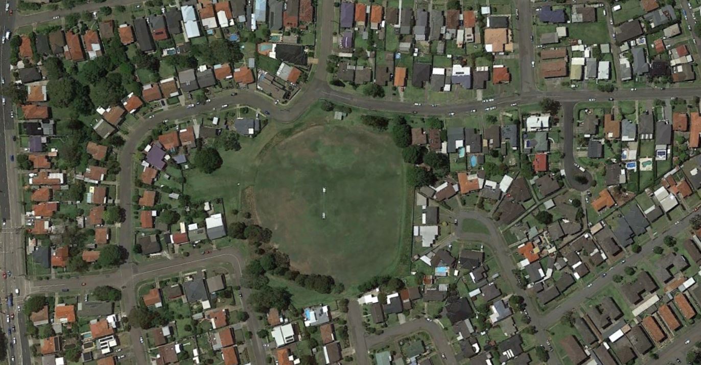
The site of the Lambton Colliery, 2016. Google Earth.
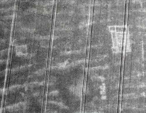
In archaeology a parch mark is where variations in vegetation growth reveal underlying archaeological features. They most often show up where stone or brick ruins underneath the surface means that there is less soil, and in dry seasons the vegetation in these areas will wither before other areas with deeper levels of topsoil, thus revealing the underlying structure in aerial photographs. Parch marks have sometimes appeared in Britain’s Channel 4 program “Time Team“, revealing ancient Roman structures.
The spectacular cropmarks of a Roman villa in North Pickenham, UK. Norfolk Heritage Explorer
I was excited to discover today photographic evidence of some historical parch marks in my own suburb. The present day Lewis Oval in New Lambton is built over the location of the former Lambton colliery, pretty much in the spot shown in the photograph below.
Lambton Colliery. Photo by Ralph Snowball. University of Newcastle Cultural Collections.
Overlaying an old map onto Google Earth confirms that the rail line and inclined mine tunnel entrance used to be where Lewis Oval is now.
I reasoned that these former excavated regions for the railway and mine tunnel would cause slight subsidences in the surface of Lewis Oval, causing water to pool in these areas more, and that in dry times the vegetation in these areas would remain greener for longer. I opened up the historical images feature of Google Earth and browsed through the available images, and bingo – there was an image from 2006 that clearly showed the location of the mine rail and tunnel. I have enhanced the contrast in the image below to make it stand out a bit more.
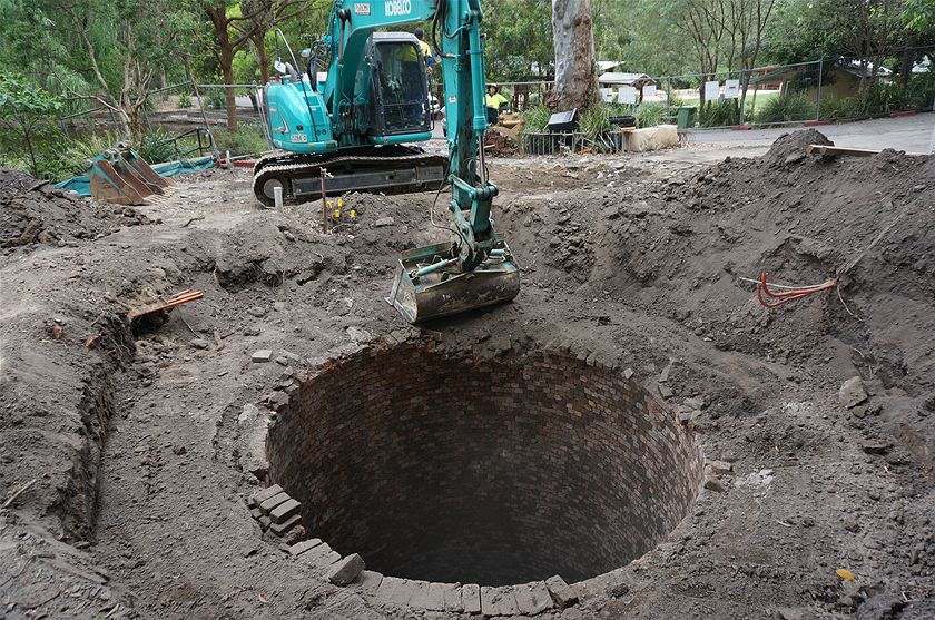
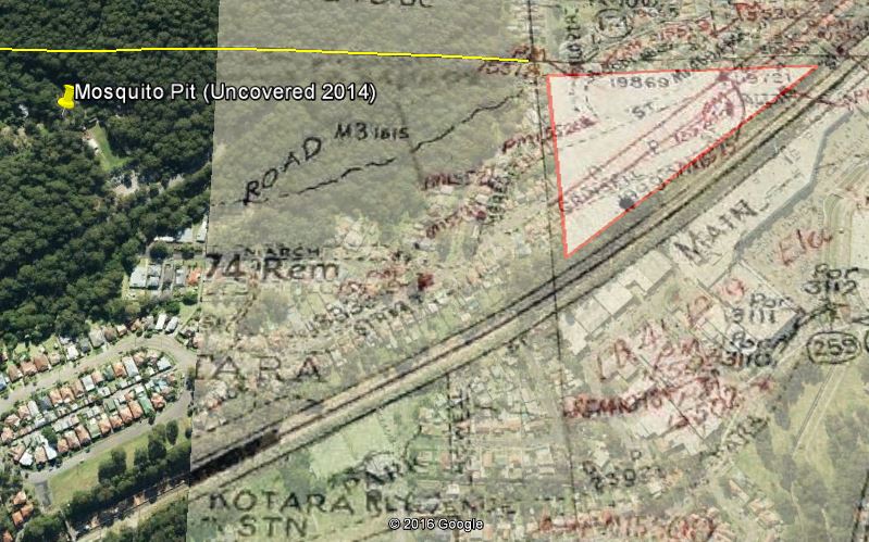
In my first article one year ago I noted there were few visible remains of the Lambton colliery, the industry that gave birth and growth to our town. Since then I have discovered a few more fragments of mining activity in the bushland around Lambton. But these are minor compared to what Newcastle Council found when carrying out renovations to the Carnley Avenue area of Blackbutt Reserve in late 2014, when an old 62 metre deep mine shaft was uncovered.
Mosquito Pit upcast shaft, 2014. Photo courtesy of ABC Newcastle – Nick Gerber.
This shaft was the “Mosquito Pit” of the Scottish Australian Mining Company, whose 1840 acre lease stretched from Lambton in the north, down to Kotara South. The shaft, also known as “Centre Pit”, was sunk in 1878 and originally used to draw coal to the surface by a rope and capstan system powered by horse.
Later the shaft was used for the vital function of ventilation, to expel stale air and poisonous gases from the mine workings, and to draw in fresh air. Before electric fans were introduced in 1926 the mine was ventilated by thermal means. By operating a furnace at the bottom of the pit, the hot exhaust fumes rose to the top of the upcast shaft, and drew cool fresh air from other downcast shafts into the mine.
The 1890 Ralph Snowball photo shows the furnace fumes rising from a circular chimney stack, whose brickwork continued below the surface down the first 11 metres of the deep shaft. It was this upcast shaft that was uncovered during the 2014 renovations.
Although Mosquito pit contributed greatly to safety in the mine, it had an inauspicious beginning. In October 1878 two men, Mr Robert Brown and the assistant colliery manager Mr Thomas Seymour, died in the recently dug shaft succumbing to poisonous gases, tragically falling victim to the very problem that the ventilation system went on to solve.
The site of the Mosquito Pit shaft in August 2016, after upgrades to the picnic area were completed.
The article above was first published in the February 2016 edition of the Lambton Local.
Corrections
The original published article stated that electric fans were introduced to the mine in 1922. The correct year is 1926.
The location of Mosquito Pit
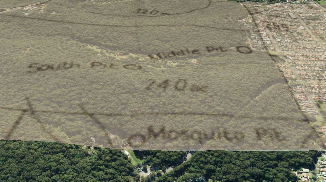
This 1932 Department of Mines map shows the location of both Mosquito Pit and Middle Pit.
Overlaying this map image into Google Earth, shows the location of Mosquito pit as being in the Carnley Ave area of Blackbutt Reserve. I did this overlay before I had heard about the council having uncovered the shaft in late 2014. This overlay shows the location of the pit only 60 metres away from the actual location of the shaft.
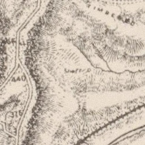
This 1925 map of the Scottish Australian Mining Company property, held in the Local Studies section of Newcastle Library, shows the Mosquito Pit location marked with “Old stack”
This 1893 map by T.S. Parrott shows Mosquito Pit simply marked with the word “shaft”.
Another interesting piece of evidence as to the location of Mosquito Pit comes from an 1887 court case between Alexander Brown and the Commissioner of Railways, where the Browns who had a mining lease in the area, were arguing about the amount of compensation they received when the construction of the Great Northern Railway cut through the corner of their mining lease, leaving an effectively unusable triangular area of 21 acres. Amidst the arguments about whether there was or wasn’t coal under this area, mention is made on day nine of the court case that
“The Mosquito was about 130 yards from the northern boundary of the disputed land.”
By overlaying an old map with the mining leases marked, the disputed triangular area can be identified, and by extending the line of the northern boundary, I measured that the shaft uncovered in 2014 is 100 yards from this line. Given the inherent inaccuracies involved in overlying and aligning old maps in Google Earth, this matches remarkably closely to the 130 yards stated in the court case.
“The Mosquito was about 130 yards from the northern boundary of the disputed land.”
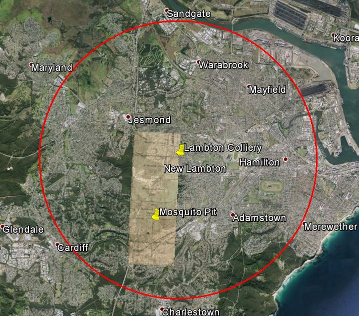
At the inquest in into the death of Mr Brown and Mr Seymour, Arthur Burnley stated that the shaft “is about three miles from the working shaft”. Presumably the “working shaft” is the shaft at the main colliery entrance near the township of Lambton, where Lewis Oval is today. The distance stated by Burnley is either an exaggeration, or the distance by road (rather than a direct line), or a combination of both. In a direct line Mosquito Pit is only 1.5 miles from the mine entrance, and in fact there is no point anywhere in the Scottish Australian Mining Company’s 1,840 acre lease that is three miles distant in a direct line from the main shaft, as the following image illustrates.
Image overlay is the 1,840 acre lease of the Scottish Australian Mining Company. The red circle is three miles distant from the main working shaft.
The shaft depth
The shaft as measured in 2014 was 62 metres deep – the top 11 metres was brick lined, the bottom 51 metres unlined. Interestingly the inquest in 1878 states that “the shaft is about 225 feet deep”, which equates to 68 metres. Given differences in where you might define the “bottom” and “top” of a shaft to be, and the erosion of material into the bottom of the shaft over 136 years, this lines up very well with the 62 metres measured in 2014.
The fatal accident
The death of Robert Brown and Thomas Martyn Seymour on Tuesday 8th October 1878 was reported in the newspaper the following day, and further details from the inquest were published the day after.
Report on 14/10/1878. The inquest concluded that the men died from the effects of “‘black damp or carbolic acid”, which is carbon dioxide. The writer suggests that it is more likely that “the gas which did the mischief was carbonic oxide”, that is carbon monoxide.
At the time of the accident, the mine manager Thomas Croudace was on leave in England, and his position was being filled by the assistant manager Thomas Seymour, who was one of the men killed. Because it was known that a manager of the mine was killed, this led to some confusion years later when in a newspaper report in 1936 on the closure of the mine, the report incorrectly stated that it was Mr Morehead who was killed in the accident. (Mr Morehead was not the locally based mine manager, but was the General Manager of the Scottish Australian Mining Company, and was based in Sydney.)
The bodies of the two men were buried in the cemetery beside St Andrews church in North Waratah. (North Waratah was the original name for Mayfield.) In a 23rd May 1902 newspaper article titled “Where Pioneers Sleep”, the details of the men’s tombstones are documented. The graves stand side by side, and bear the following inscriptions:
Sacred To the memory of THOMAS MARTYN SEYMOUR. Assistant manager of the Lambton Colliery, who met his death through an accident in that colliery on October 8, 1878, Aged 25. Much esteemed and regretted.
On the stone adjoining there appears:
Sacred To the memory of ROBERT BROWN, Miner, Husband of Elizabeth, and son of John and Mary Brown, who met his death through an accident in the Lambton Colliery on October 8, 1878, Aged 23. Much esteemed and regretted.
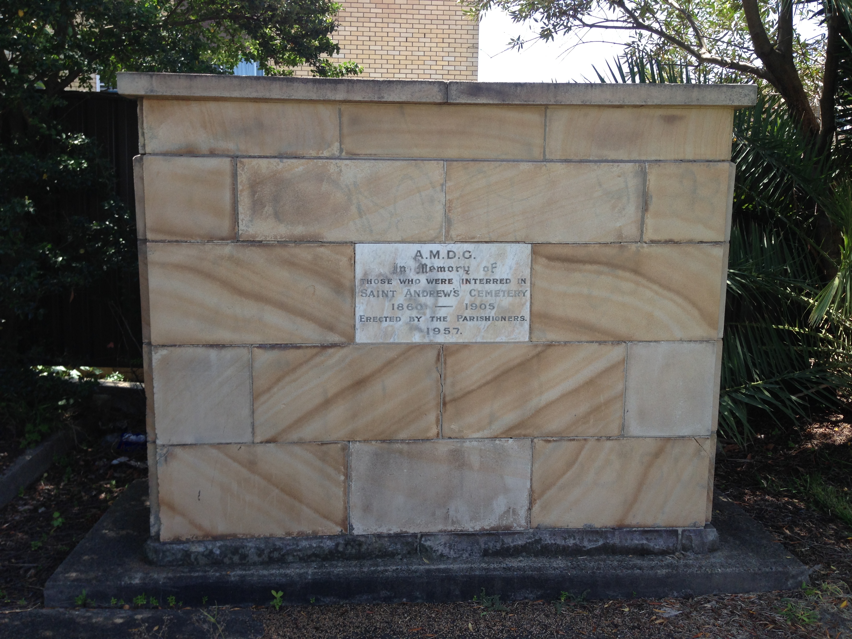
Although St Andrews church is still there today, the cemetery is not. In 1957 the old cemetery, which had been closed since 1905, was cleared to make a site for the new church hall. In a curious circularity for the men of this story, the headstones in the cemetery were broken up and transported to Blackbutt Reserve to be used as construction materials , thus returning the headstones close to the site where the men met their untimely deaths.
Memorial erected at St Andrews church Mayfield, in 1957 when the cemetery was removed.
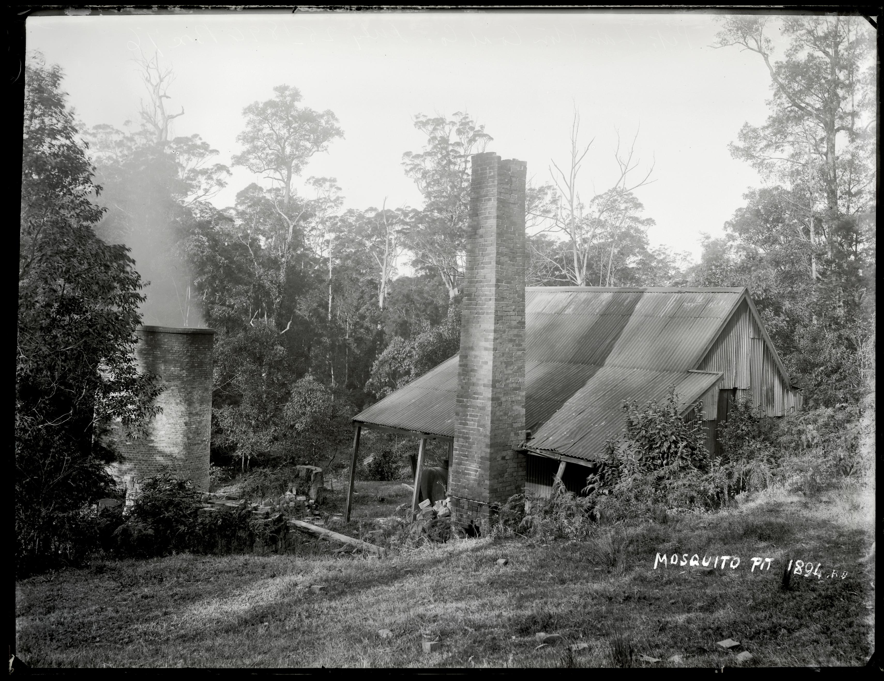
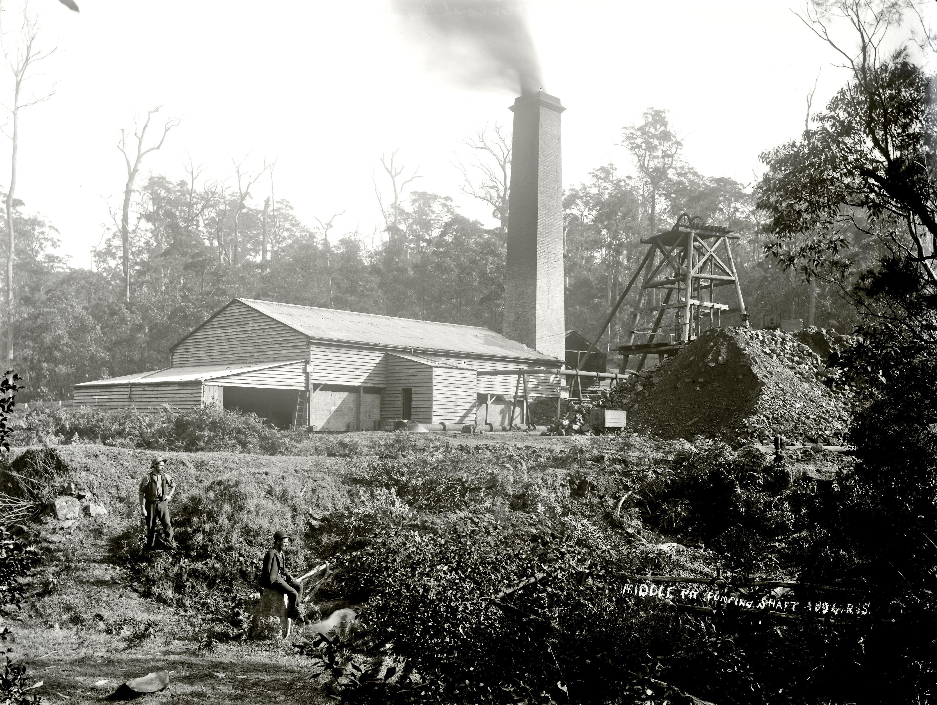
Centre Pit / Middle Pit
In the article I mention that “Mosquito Pit” was also known as “Centre Pit”. Despite the similar meaning name, this is not the same as “Middle Pit”, which was also a shaft of the Scottish Australian Mining Company. At the inquest into the death of Robert Brown and Thomas Seymour, the deposition of William Short to Mr Mackenzie clearly shows that “centre pit” and “middle pit” were two separate shafts …
“at the Lambton middle pit there was a furnace at the bottom, and a brattice in the shaft ; there was much more area behind the brattice at the middle pit than at the centre pit, where the area is only 227 square inches; the shaft in the former case was nine feet, and in the latter only seven feet six inches”
Later on Middle Pit was primarily used as a pumping shaft, to extract water out from the low lying areas of the mine. Ralph Snowball photographed Middle Pit in 1894. Middle Pit was located near the Richley Reserve entrance to Blackbutt Reserve.
Coal Mine Ventilation
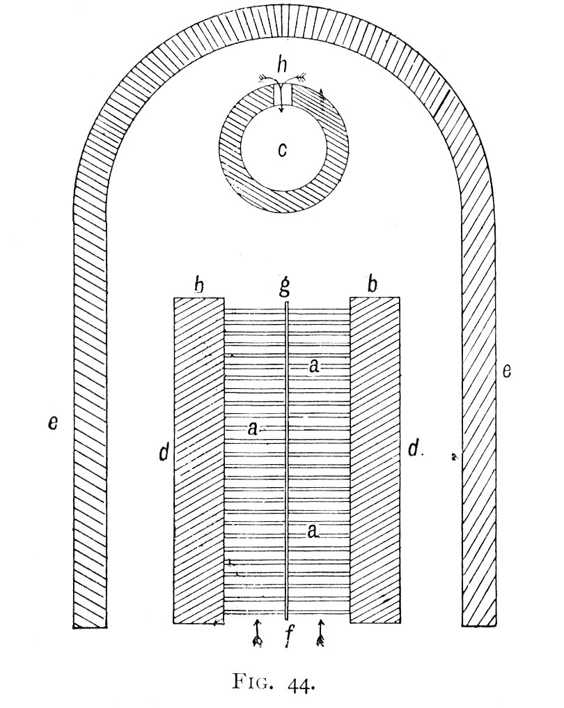
The University of Newcastle Cultural Collections has in its photo archive, scanned pages from a 1906 book “First Lessons in Coal Mining”. This book by William Glover was written “for use in primary schools”, which shows how much our educational curriculum has changed in the last 110 years! The book has a section on pages 70-82 with very good simple descriptions of the methods for ventilating coal mines, including some instructive diagrams.
The furnace at the bottom of an upcast ventilating shaft. “First Lessons in Coal Mining” page 71. University of Newcastle Cultural Collections.
In the article, I describe how thermal ventilation is achieved with a furnace at the bottom of an upcast shaft drawing fresh air from other downcast shafts. While this is the usual arrangement, it is also possible to use a single shaft for both the upcast and downcast, by installing a ‘brattice’ down the length of the shaft to divide it into two separate sections. Page 80 of “First Lessons in Mining” describes bratticing as “a kind of coarse, strong, tarred canvas”. In 1878, the Mosquito pit shaft was only recently dug and was not yet connected to other parts of the mine, so at the time of the fatal accident the shaft was “bratticed with wood” and was being used for both downcast and upcast, as evidence from the inquest shows:
“the shaft is about nine or ten feet wide ; the brattice was only from six inches to a foot off the side of the shaft, and was intended for an upcast; the furnace was only an iron fire-lamp, and about two yards from the edge of the shaft”
Last weekend I revisited the site of Paddy Lewis dam, with some friends in tow, in search of more remains of the engine house of the Lambton Colliery that was once there.