The University of Newcastle Living Histories site has a Ralph Snowball photo with the caption “Construction of the water reservoir, New Lambton, NSW 1917”. In tracking down the location of this photo, thanks to Robert Watson I somewhat surprisingly ended up in a different suburb and a different year.
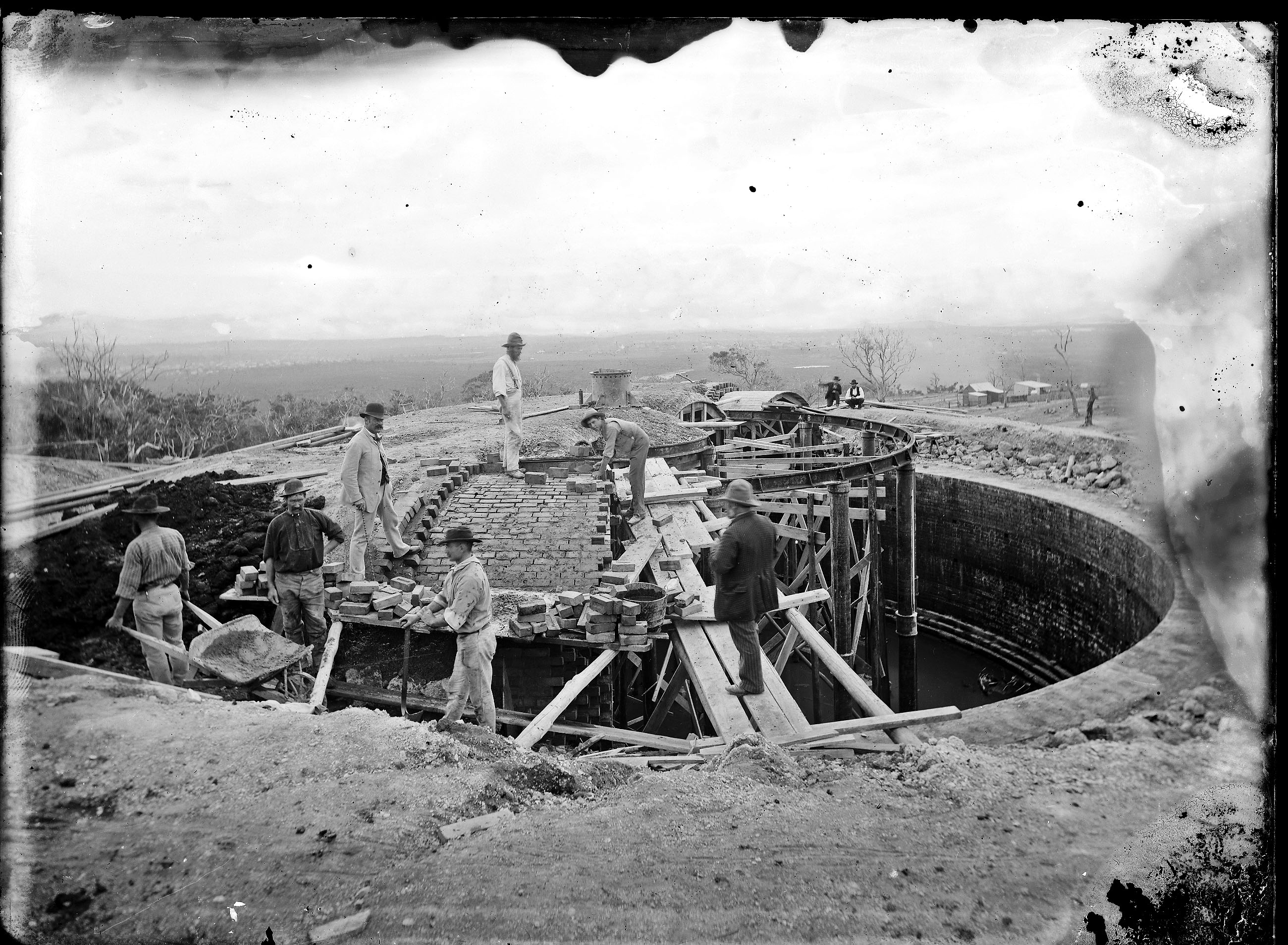
Construction of Glebe Hill Reservoir, 1886. Located at 65 Macquarie St, Merewether. Photo by Ralph Snowball. University of Newcastle, Living Histories.
Part 1: Ridgeway Road?
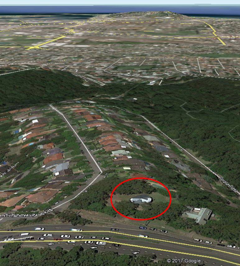
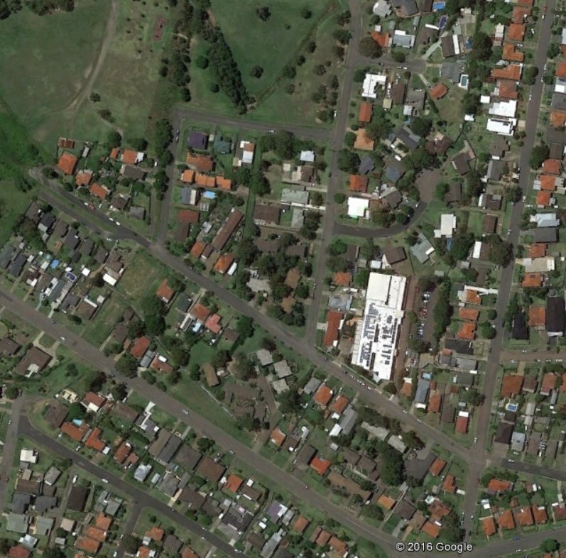
Given that the photo is taken from an elevated position overlooking a flat plain I had always assumed that the location was where the reservoir now is at the top of Ridgeway Road, New Lambton Heights.
Water Reservoir site, corner of Ridgeway Rd and Lookout Rd, New Lambton Heights.
A search of Trove appeared to confirm my assumption, with a 9th January 1917 newspaper article reporting that
“The construction of the NewLambtonreservoir was completed on the 3rd instant, and after satisfactory tests were made the reservoir was brought into use.”
Further investigation however cast serious doubt on this being the site of the Snowball photo, for none of the other details matched up.
the topography of the land wasn’t right – there is a deep gully below Ridgeway Rd, but in the photo the land slopes down more gently.
the reservoir in the photo was of brick construction, but the New Lambton reservoir was of reinforced concrete.
the reservoir in the photo was large (from estimates of the dimensions in the photo I calculated the capacity to be 350,000 imperial gallons) whereas the New Lambton reservoir was only 50,000 gallons.
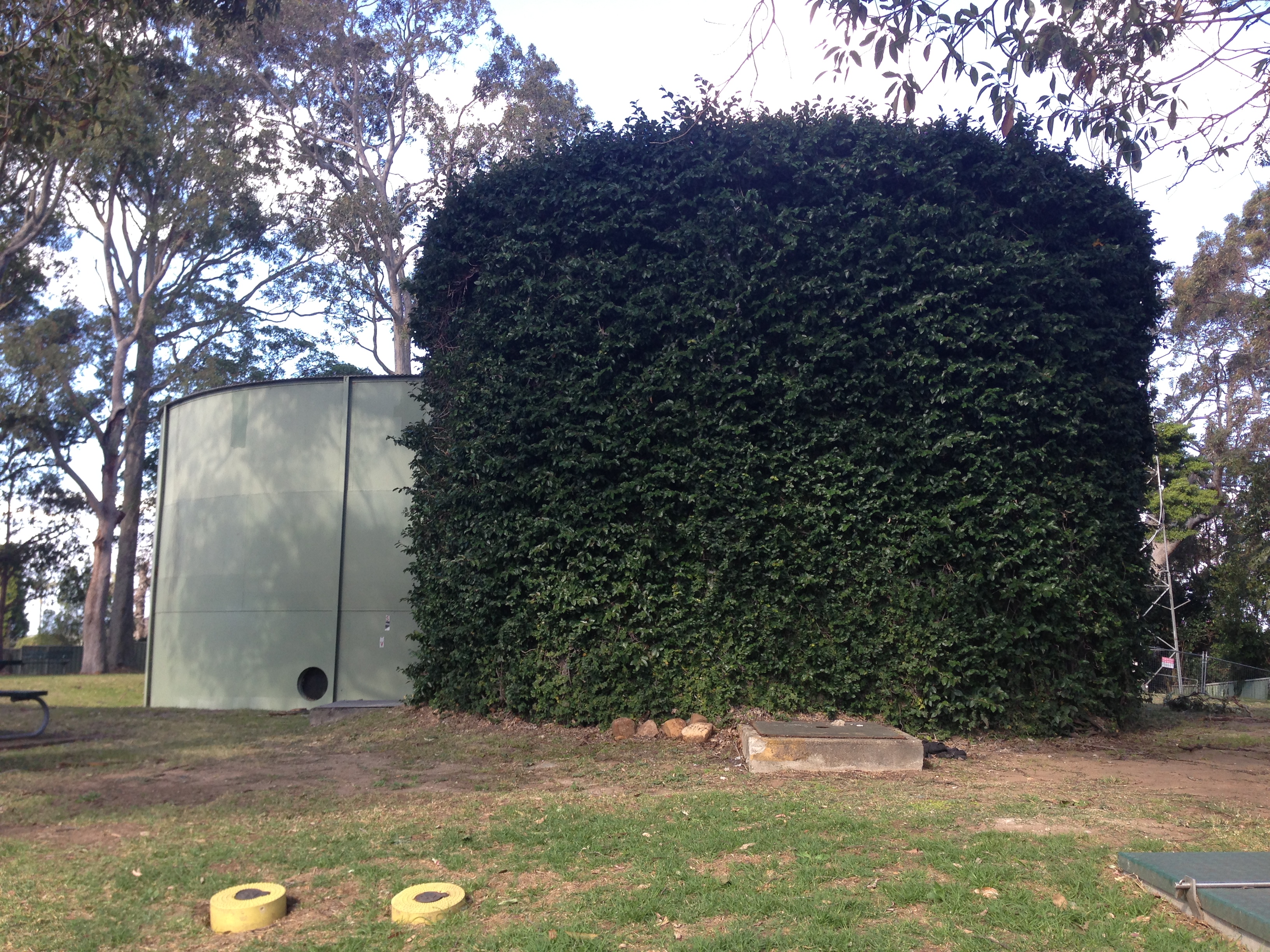
Visiting the site of the Ridgeway Rd reservoir revealed that the 50,000 gallon 1917 reservoir is still there, covered in ivy, beside the new 1954 steel reservoir. It is clearly not the reservoir in the Snowball photo.
The 1917 ivy covered concrete reservoir, Ridgeway Rd, New Lambton Heights.
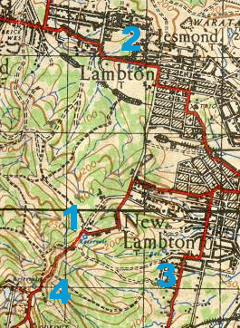
On the horizon of the Snowball photo there is a very faint outline that appeared to me to be the outline of Shepherd’s Hill on the coast. What other reservoirs on the hills around the Newcastle would provide a view eastwards over the flatlands towards the coast?
A 1940 map of Newcastle shows reservoir locations as small blue circles. Having ruled out the Ridgeway Rd site [1], I then considered Lambton Reservoir [2], St James Rd Reservoir [3], and Lookout Reservoir [4].
Lambton Reservoir was built in 1885 and sits in the middle of Newcastle Road at the top of the hill.
Lambton Reservoir, Newcastle Road.
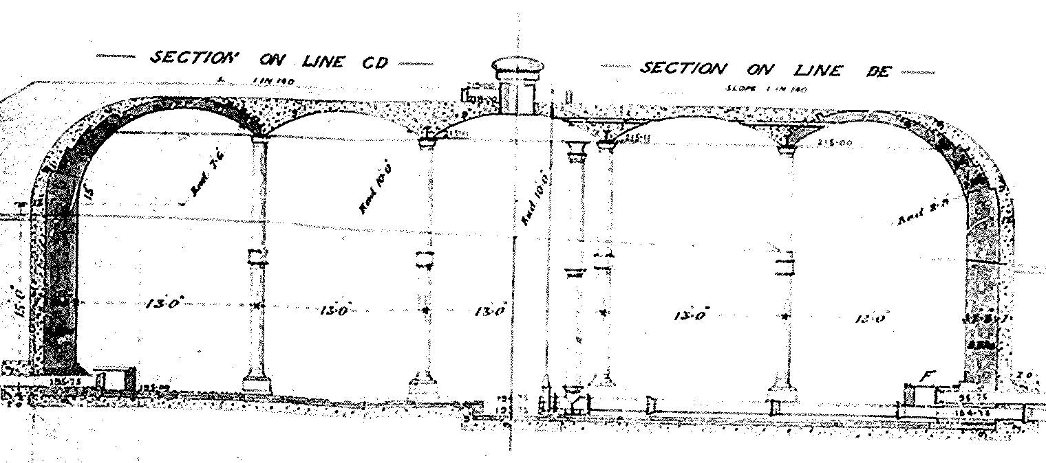
Interestingly, a drawing of the Lambton Reservoir shows that it is the same design as the reservoir in the Snowball photo, with a central dome and two concentric rings of arches to form the roof.
Design of Lambton Reservoir, 1885.
But despite the similarity of design, the topography of the land in the photo doesn’t match. If the photo was of Lambton Reservoir we would expect to see the township of Lambton (including the very prominent Post and Telegraph Office building) before us.
Part 3: St James Road?
The reservoir (marked 3 in the map above) in New Lambton, between St James Rd and Queens Rd was built soon after August 1926. It didn’t seem to match up too well with the shape of the land in the Snowball photo – the St James Rd reservoir appears to have a slight ridge to its right, which is absent in the old photo. Also in 1926 we would expect to see the growing suburb of New Lambton below the reservoir, instead of the large expanse of scrub land that we do see.
Reservoir, between St James Rd and Queens Rd, New Lambton.
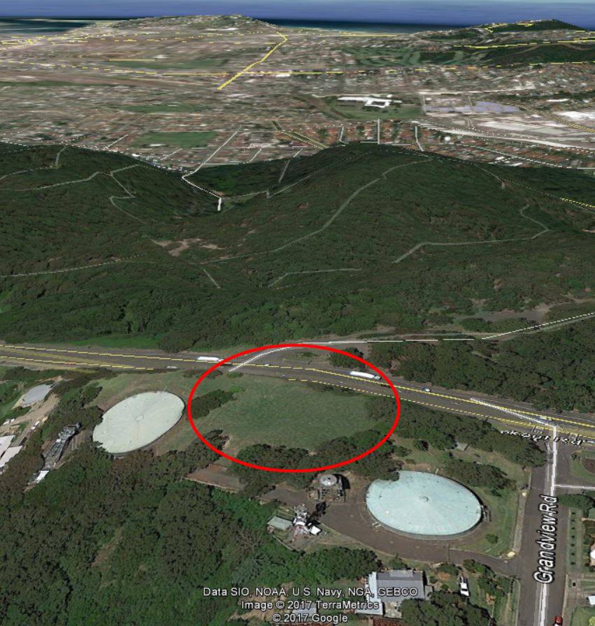
Part 4: Lookout?
The reservoir marked 4 on the map above was known as the Lookout Reservoir. It also was constructed on 1926, and its location can still be seen in the empty circular space between the two newer above ground steel reservoirs.
Location of the “Lookout Reservoir”, corner of Grandview Rd and Lookout Rd, New Lambton Heights.
The “Lookout Reservoir” seemed to be a better candidate for the Snowball photo in terms of the shape of the land and size of the reservoir, but it led me to an impossible conclusion … the “Lookout Reservoir” was constructed in 1926, but Ralph Snowball had died in August 1925, before construction had begun!
Part 5: Merewether?
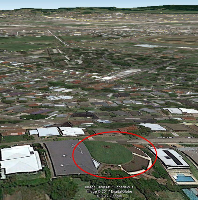
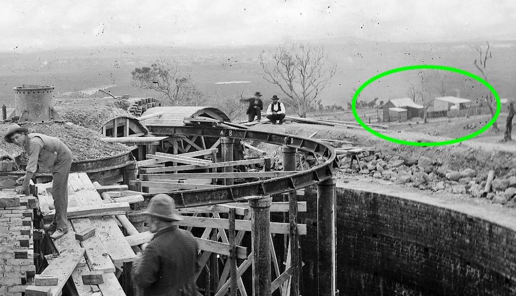
At this point, Robert Watson came to my aid, and with some inspired thinking rescued me from my impossible conclusion. He deduced that the reservoir in the Snowball photo is actually situated in Macquarie St, Merewether.
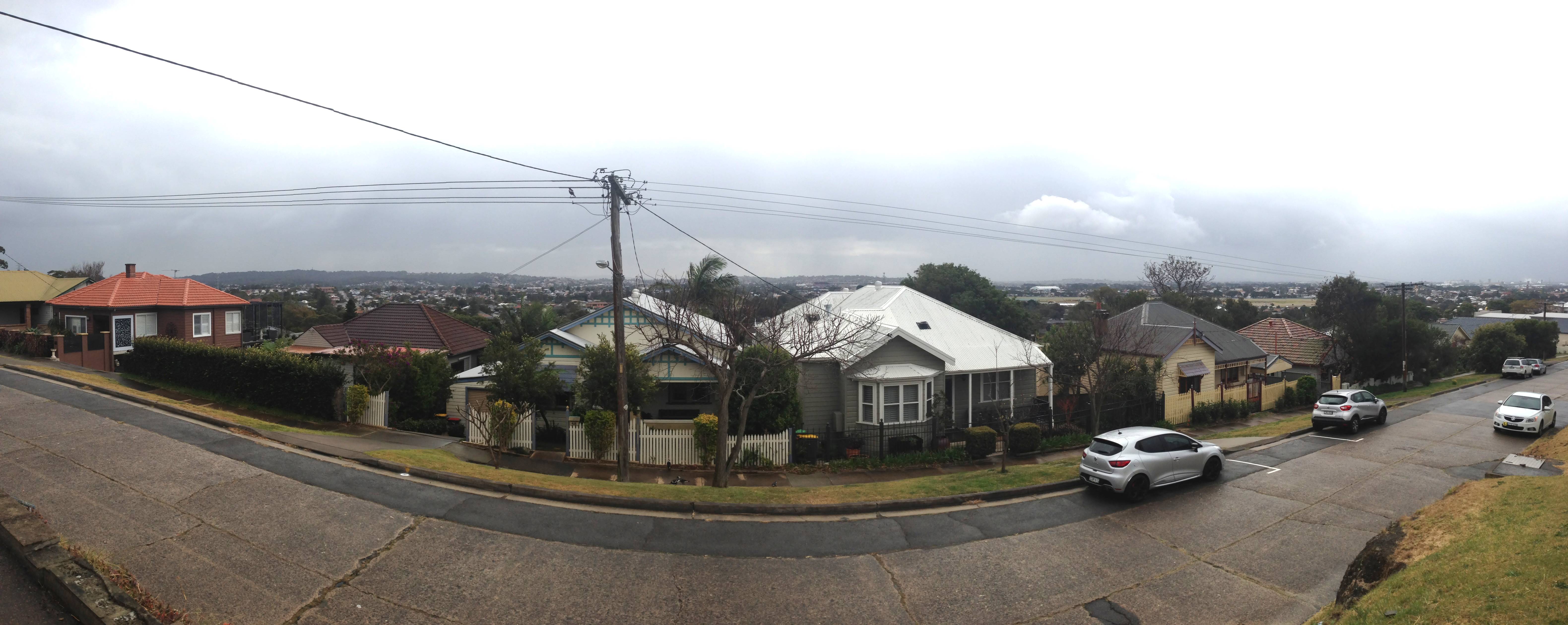
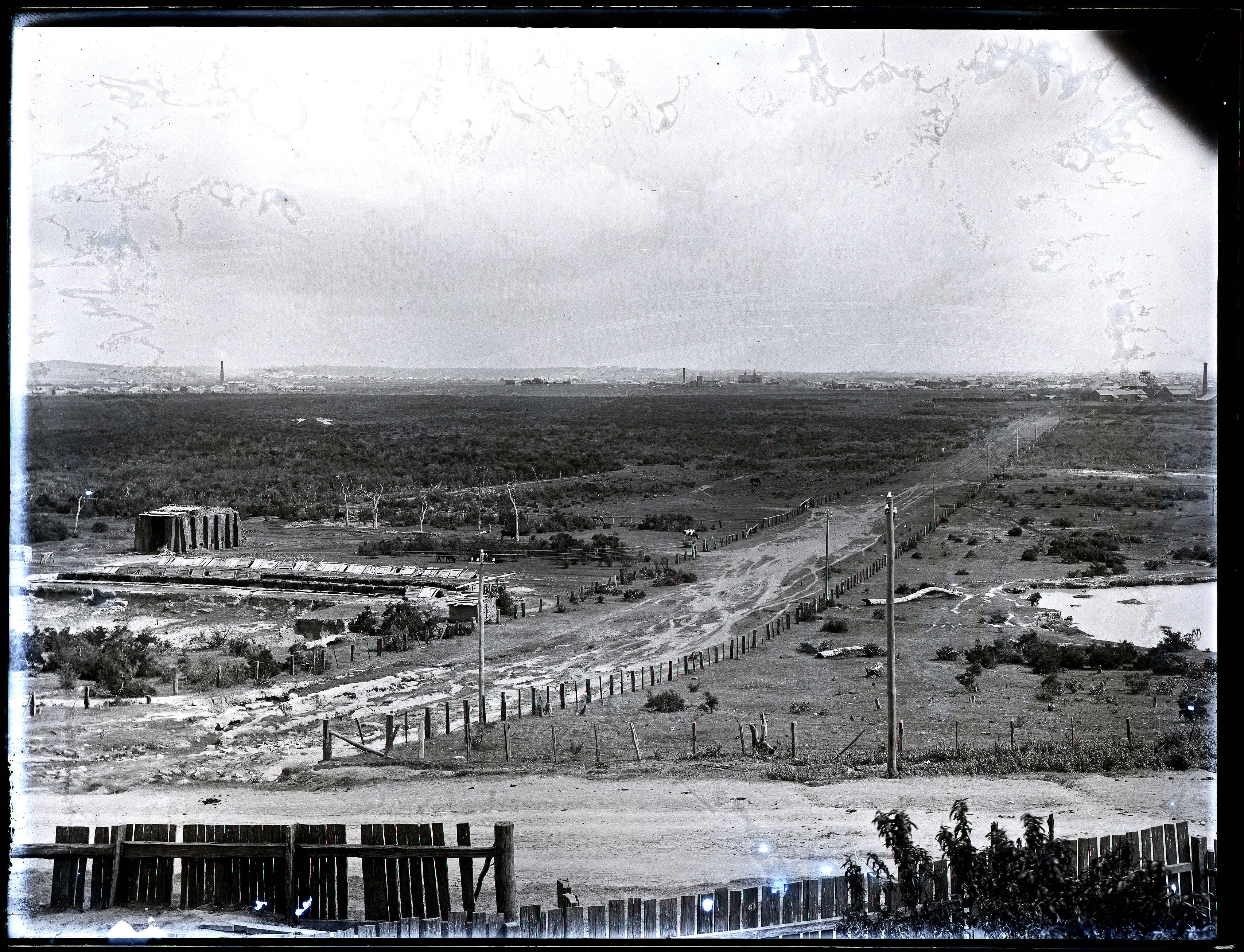
I had led myself astray in too quickly assuming that the Snowball photo was looking east towards the coast. It is in fact looking north-west, across the Broadmeadow flatlands towards Waratah.
Glebe Hill Reservoir, Merewether.
Panorama from the site of the Glebe Hill reservoir.
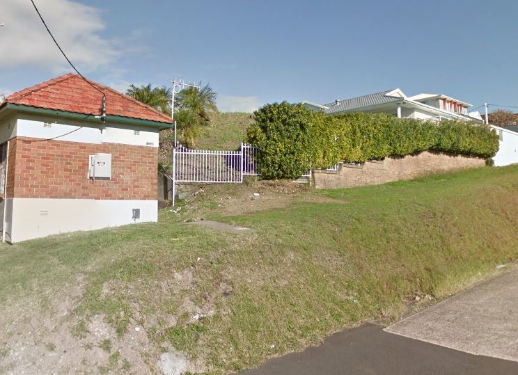
Glebe Hill Reservoir in Macquarie St Merewether is now part of a private residence. Google Street View.
A newspaper article from May 1886 states that the construction of the reservoir began in November 1885, only three months after the Lambton reservoir was completed in August 1885. The article contains a detailed description of the design that matches the photo very closely.
The roof is formed of two concentric arched rings and a dome carried by cast-iron girders, supported by iron columns resting on stone foundations some two feet square.
A March 1887 article describing the Hunter River District Water Supply shows that the Glebe Hill reservoir was almost identical to the size to the Lambton reservoir.
The reservoir at Lambton is built on the hill above the Public school, a distance of twelve and a half miles from. Buttai. It will hold 402,600 gallons. At fifteen and a third miles from Buttai a 15-inch branch pipe, a mile and a quarter in length, is connected with a reservoir having a capacity of 403,000 gallons, to supply Hamilton, Adamstown, the Glebe, and other towns along the line.
Note that although the reservoir is located within the modern day suburb boundaries of Merewether, it is sometimes called the “Hamilton Reservoir”, as that was the principal township it served.
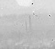
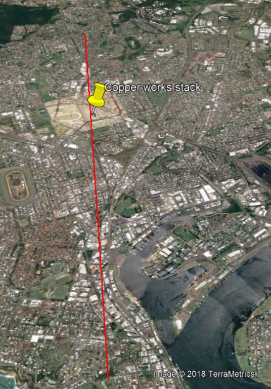
Some other hints that confirm that the Snowball photo is of the Glebe Hill reservoir are the faint outline of smoke stacks in the distance. At the right are two stacks of different size, close together.
Broadmeadow copper smelter stacks.
These are the stacks of the English and Australia Copper Company smelter at Broadmeadow.
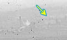
To the right is a single stack of one of the A.A. Company pits in Hamilton, and the very faint outline of the roof of St Peters Church in Denison St, Hamilton.
The Glebe Hill reservoir photo is taken from a spot only about 400 metres away from another Ralph Snowball photo taken in 1897, which shows the same landmarks in the distance.
1886 Glebe Hill Reservoir photo (top) and 1897 Glebe Rd photo (bottom)
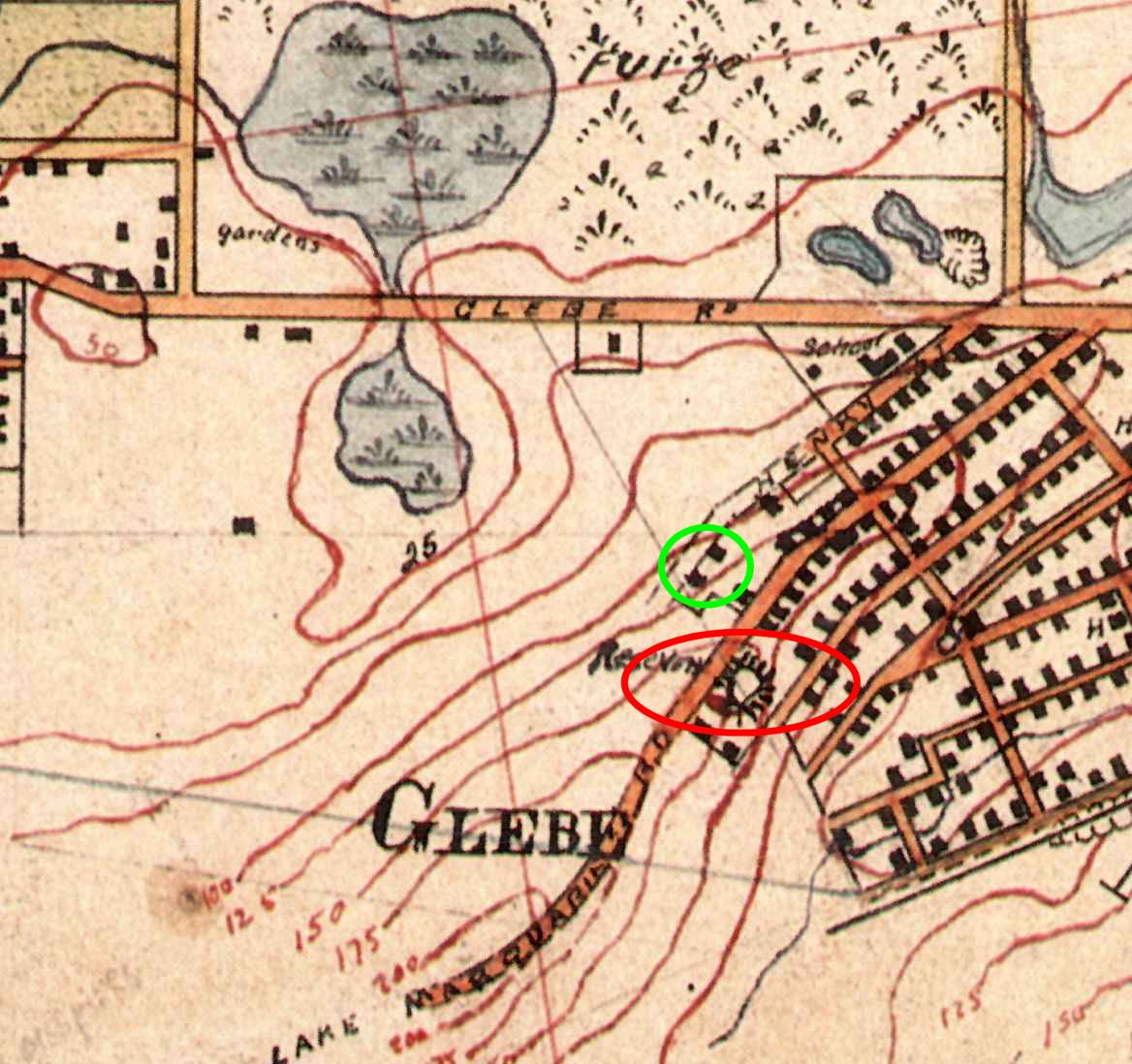
The Glebe Hill reservoir is marked on Corporal Barrett’s 1910 map of Newcastle, situated on Lake Macquarie Rd. Quite possibly the two buildings marked at the end of Henry St are the two buildings we see in the Snowball photograph.
My thanks to Robert Watson who had a substantial input into the content of this article. Thanks also to Brendan Berghout of Hunter Water, who pointed me towards some useful information on early water supply infrastructure, and who helpfully reminded me that imperial gallons (220 gallons/m3) are not the same as U.S. gallons (264 gallons/m3). It was a casual conversation with Brendan on a bicycle commute to work one morning that was the genesis of this journey of discovery.
Blackbutt Reserve today owes its existence to a strange combination of business prosperity, national adversity, and private tenacity.
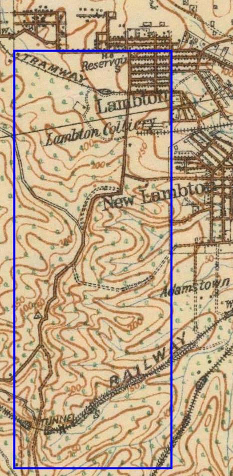
The current area of the Reserve lies wholly within the boundaries of a coal mining lease of the Scottish Australian Mining Company. The eighteen hundred acre lease extended from Kotara South to Jesmond. Mining commenced in 1863, and apart from occasional downturns, the colliery prospered. Therefore, above ground there was little development apart from buildings such as pumping stations, required to support underground mining operations.
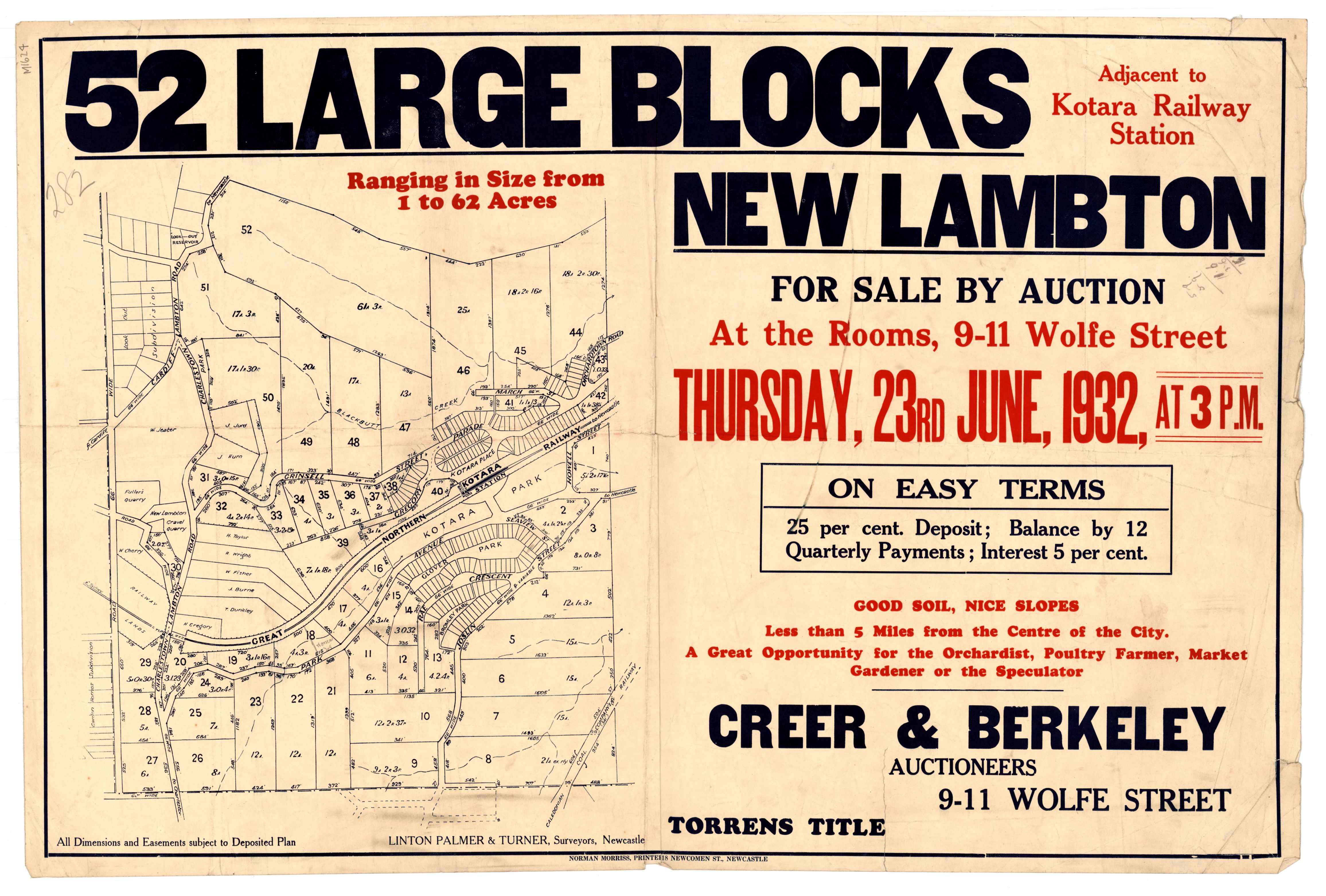
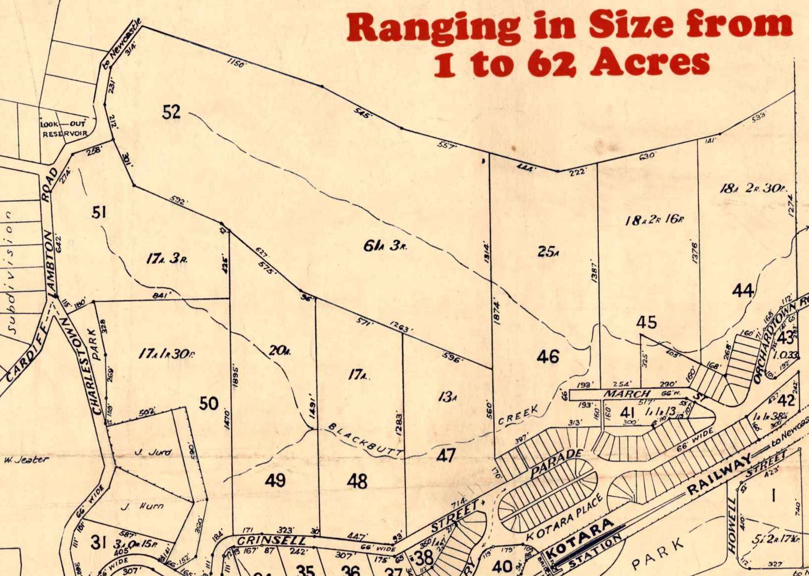
However, with the depletion of coal, and rising land taxes, the S.A.M Company looked for other income, from real estate. Between 1915 and 1928 the company developed and sold a few small subdivisions in Lambton, New Lambton, and Kotara. In June 1932, they attempted to auction a large parcel of land, in what is now the southern part of Blackbutt Reserve. The nation at this time however, was suffering the adversity of economic depression. There was little appetite for land purchases, and only five of the 52 lots on offer were sold. The failure of the auction thus left open a window of opportunity for local councils to purchase the land for a nature reserve, starting with 17 acres on Lookout Road in 1938, and increasing to 144 acres by 1940.
In 1956, Newcastle Council bought another 270 acres from the S.A.M. Company, in what is now the northern part of Blackbutt Reserve. Council wanted to subdivide all this land for housing, but through the tenacious opposition of private citizens and community groups, this development was blocked. Instead, the land was added to Blackbutt Reserve. Community opposition had to swing into action again in 1966 to prevent the Department of Main Roads building an expressway through the Reserve.
Many individuals worked tirelessly for the establishment and preservation of Blackbutt Reserve. One in particular, Joe Richley, president of the Northern Parks and Playgrounds Movement for 20 years, is commemorated in the name of Richley Reserve.
The approximate site of Middle Pit in 2017, at the entrance to Richley Reserve.
The article above was first published in the July 2017 edition of the Lambton & New Lambton Local.
Acknowledgement
One of my main sources in researching and writing this article was “A History of Blackbutt Nature Reserve” by John Ramsland, University of Newcastle, a manuscript written for the Blackbutt Reserve Local Committee as a contribution to the Australian Bicentennial Celebrations. A copy of this manuscript is held in Newcastle Region Library Local Studies Section, Q719.32/RAM.
Two views of Blackbutt Reserve, which is being acquired by the municipal councils of the district for retention as a public park. From the shelter shed there is a commanding view of Newcastle.
The 1888 map below, held by the NSW Land and Property Information, shows the 1840 acres of mining lease held by the Scottish Australian Mining Company in the name of “Morehead & Young”, in the following lots:
Lot 23 – 320 acres
Lot 167 – 320 acres
Lot 171 – 320 acres
Lot 172 – 240 acres
Lot 173 – 320 acres
Lot 174 – 320 acres
1888 map showing mining leases of Scottish Australian Mining Company. NSW Land and Property Information.
Fifty years after mining commenced in 1863, a 1913 War Office map shows that the only area of the 1840 acre mining lease with residential development is the township of Lambton in the north west corner.
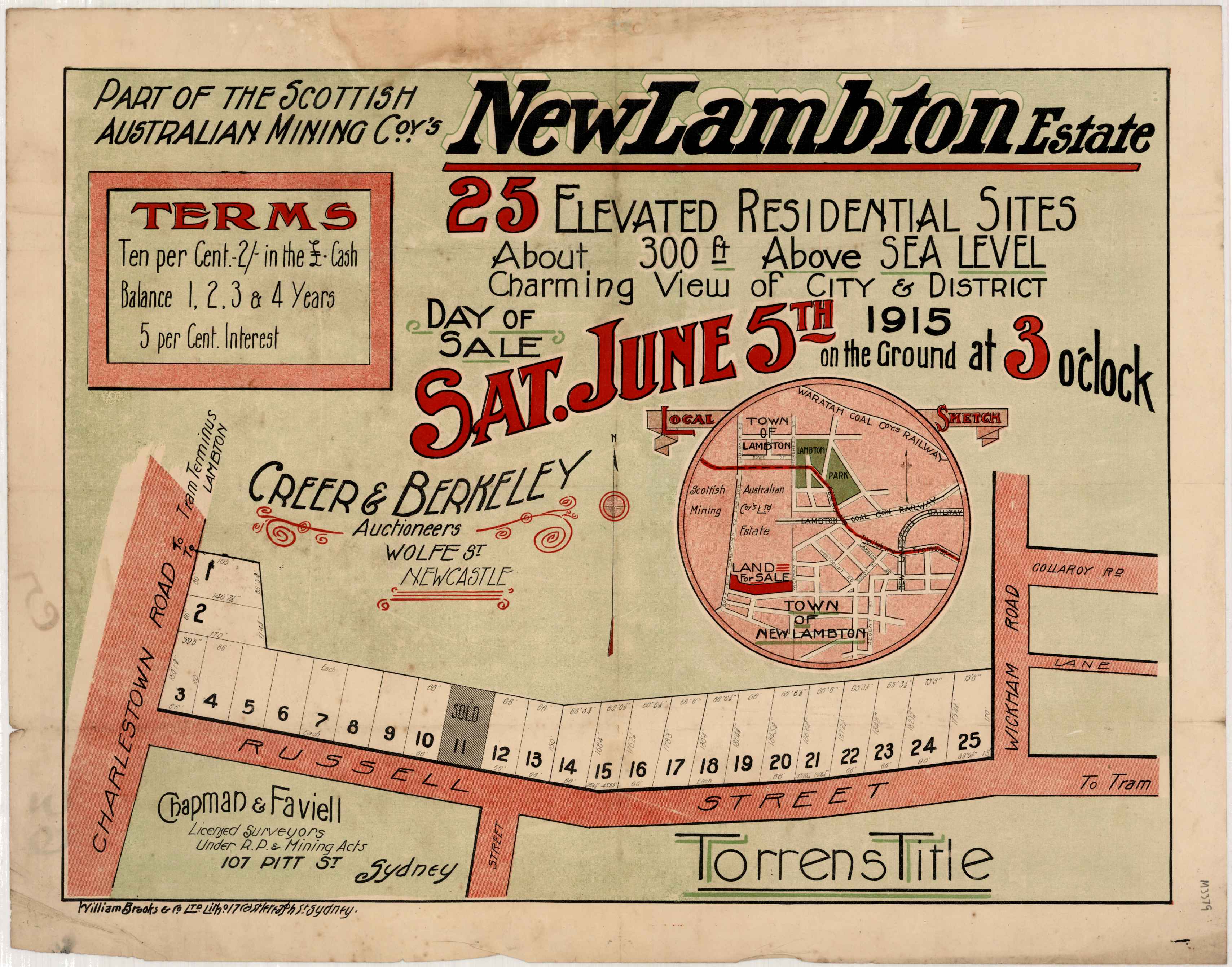
From 1915, the Scottish Australian Mining Company started developing and selling residential subdivisions, starting with 24 blocks of “Lambton Park Estate” fronting Howe St, in May 1915.
Twenty five blocks on Russell St New Lambton were offered for sale in June 1915. (All real estate posters are from the University of Newcastle Living Histories site.)
Fifty seven blocks surrounding Chilcott St Lambton were offered for sale in January 1920.
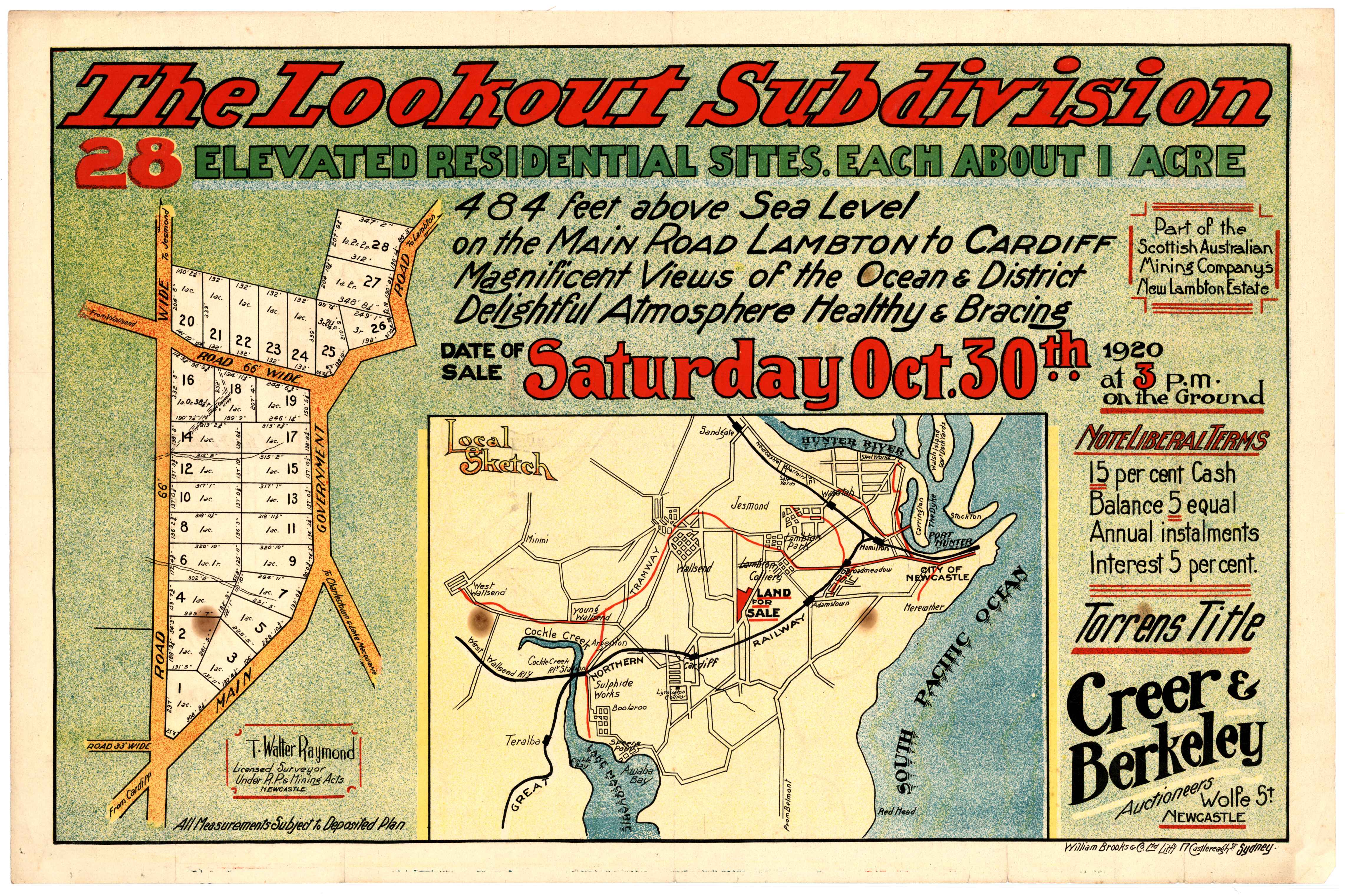
Twenty eight blocks in New Lambton Heights were offered for sale in October 1920.Ten blocks on Curzon St and Carrington Pde, New Lambton were offered for sale in December 1921.
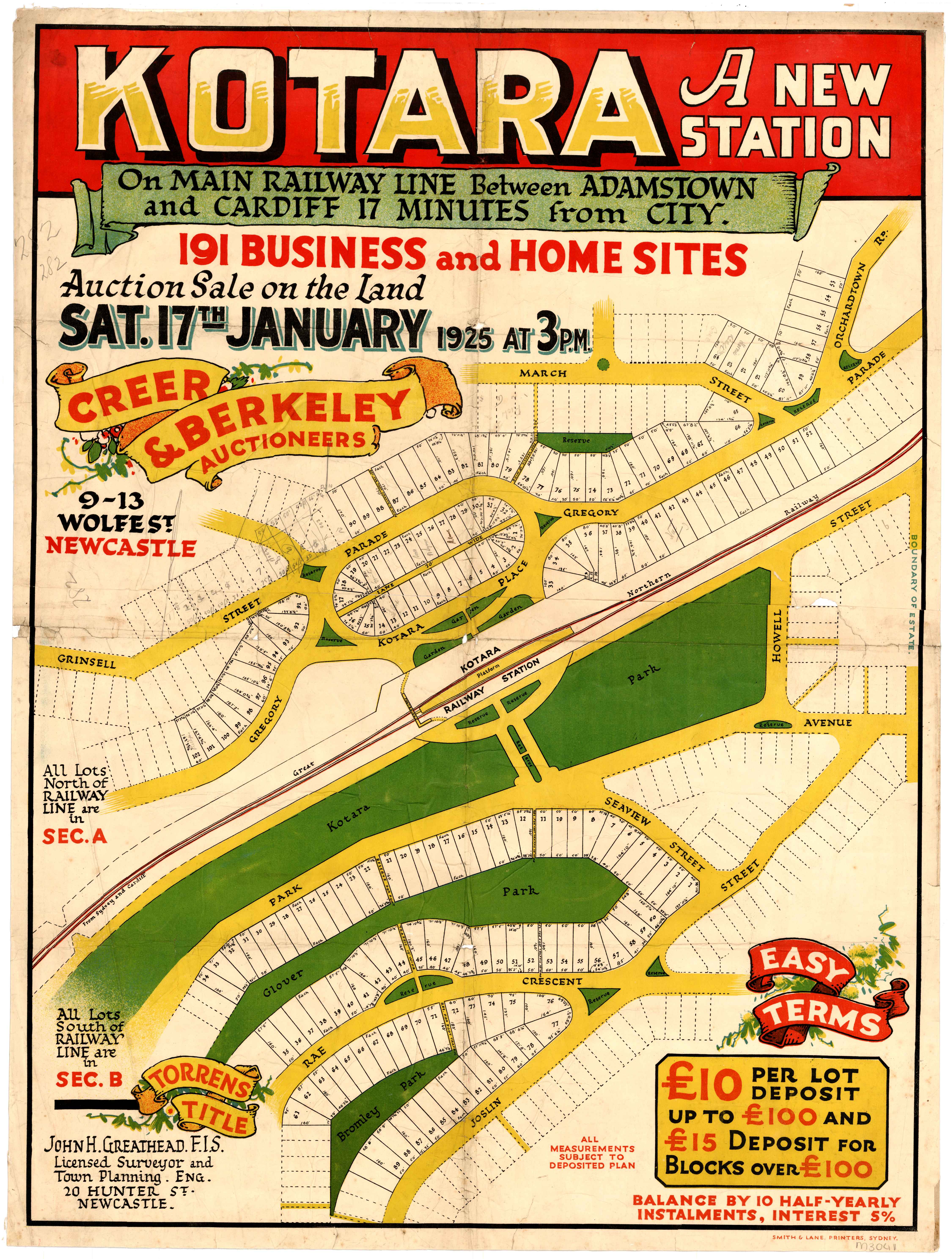
191 blocks in Kotara were offered for sale in 1925.
Twenty six blocks on Turner St Lambton were offered for sale in 1928.
In 1932, the Scottish Australian Mining Company attempted to auction 52 blocks of land, totalling 480 acres. With the country in the grip of the Depression, the auction was a failure, with just five of the 52 blocks selling.
One of the blocks that sold was Lot 51, on Lookout Rd. This was bought by the Newcastle Branch of the Returned Sailors and Soldiers Memorial Institute. It was this block that became the first officially gazetted portion of Blackbutt Reserve in March 1938.
The 17 acres and 3 roods of Lot 51 on Lookout Road, was the first portion of Blackbutt Reserve to be officially gazetted. University of Newcastle, Living Histories.
By September 1940, the size of Blackbutt Reserve had been increased to 144 acres, as shown on this Parish Map of Newcastle. The 144 acres consisted of Lots 48 to 52, and part of lot 47 of the 1932 subdivision.
It is interesting to see how the modern boundaries of Blackbutt Reserve fall entirely within the S.A.M. Company’s mining lease, an indication of how the underground mining activities there in the 19th century left large areas of the surface undeveloped, and available for a nature reserve in the 20th century.
Blackbutt Reserve in relation to the S.A.M. Company mining lease.
Middle Pit
The first reference in Trove to the Middle Pit is from January 1875, in relation to driving “two narrow bords four yards wide for water standage.”
It is uncertain when the Middle Pit pumping shaft ceased operation. It was still in use in June 1913, as an article refers to the damage done to Orchardtown Road in the course of carting coal to Middle Pit, presumably to fire the engine boilers. A December 1937 article reported on the attempted rescue of a dog that had purportedly fallen down the shaft. The site had obviously been unused for quite a number of years, judging by the description …
The disused shaft is known in the locality as Middle Pit, and was formerly used in connection with the workings of the Old Lambton mine. Pit top gear, including an old rusted winding wheel, is still there, but the pit itself has fallen into disuse. It is in a deep gully, and nobody would suspect its presence when more than 100 yards away. Thick lantana has grown almost to the edge; briar bushes form a barrier between the outside world and the old shaft. The only sound is the sighing of wind in the gum trees. In the interests of safety the shaft has been enclosed by a tall galvanised iron fence. The ground at the foot of portion of the fencing has worn away, and through this hole the dog probably slipped in.
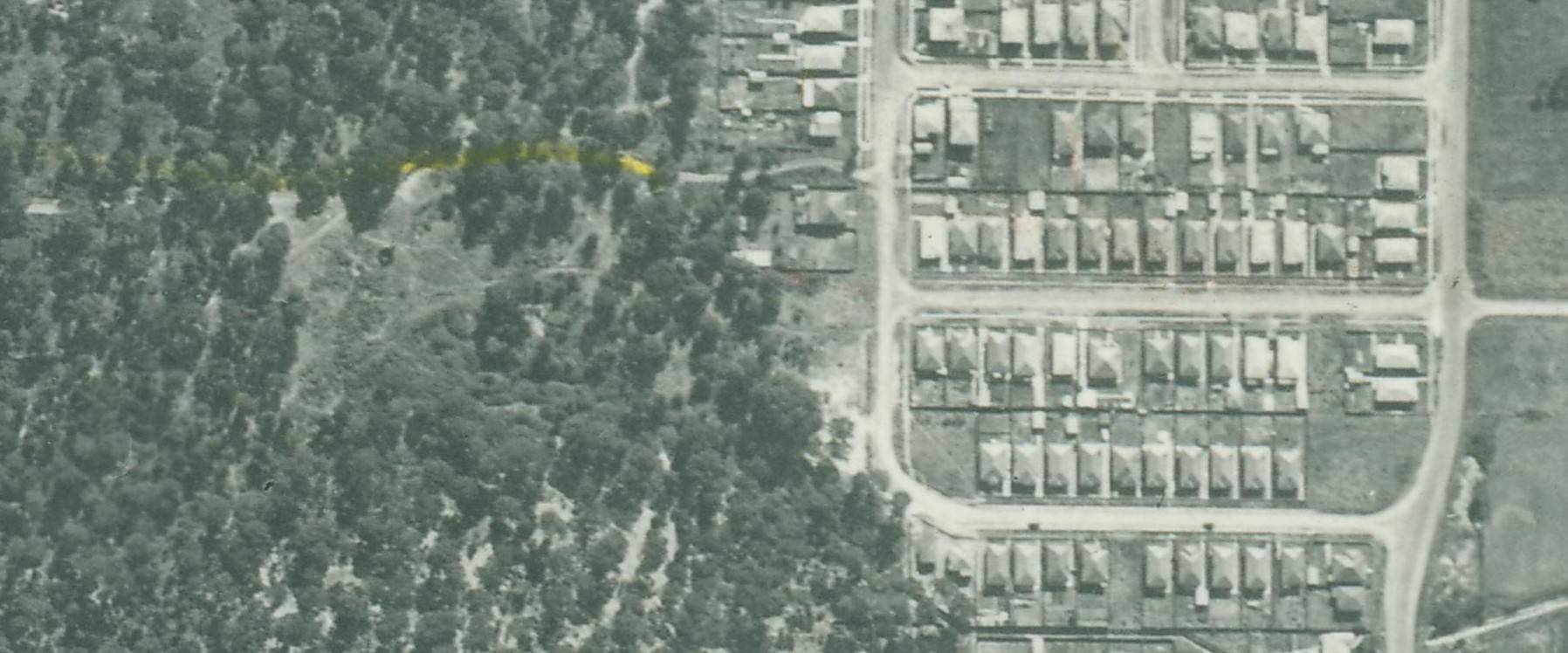
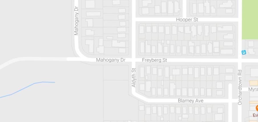
In this 1944 aerial photo the location of Middle Pit can be seen in the bare area to the west of Freyberg St. NSW Historical Aerial Imagery
Thirty to forty aldermen of the city and district inspect the Blackbutt area. The Mayor of Newcastle (Ald Parker said that they "were definitely impressed that if acquired for a reserve it would be an asset to the district."
"An area of 17¾ acres in Blackbutt Reserve imnmediately below the Look-out, has been bought by the Returned Sailors and Soldiers' Memorial Institute. The purchase will serve a dual purpose, for not only will returned men willing to work for any relief they may obtain from the Institute carry out their undertaking there, but the Institute will settle a few ex-service men there on small allotments."
This block became the first official part of Blackbutt Reserve in 1938.
Convinced that Blackbutt Reserve is inappropriately named, the Mayor of Newcastle (Ald. H. Fenton), in his capacity of Chairman of the Local Govern
ment Coordination Committee, is urging the adoption of a more attractive title. He suggested last night that if the reserve was dedicated as a memorial to King George V., it could be called the "King George V Memorial Park." Or there might he support, Ald. Fenton added, for a proposal that the area be
known as the "Duke of Windsor Reserve."
A public meeting will be held to protest against the Main Roads Board decision to route a six-lane highway through Blackbutt Reserve.
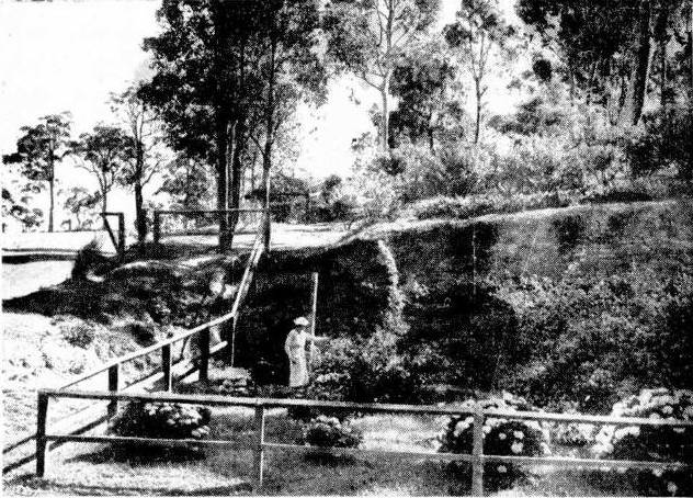
A few hundred metres from the site of Middle Pit, in the bush adjacent to Richley Reserve, lies this rusting coal bucket, a poignant symbol of the way in which the decline of coal mining gave rise to a nature reserve.
Rusting remains of a coal bucket, lying in the bush close to Richley Reserve.
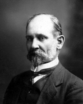
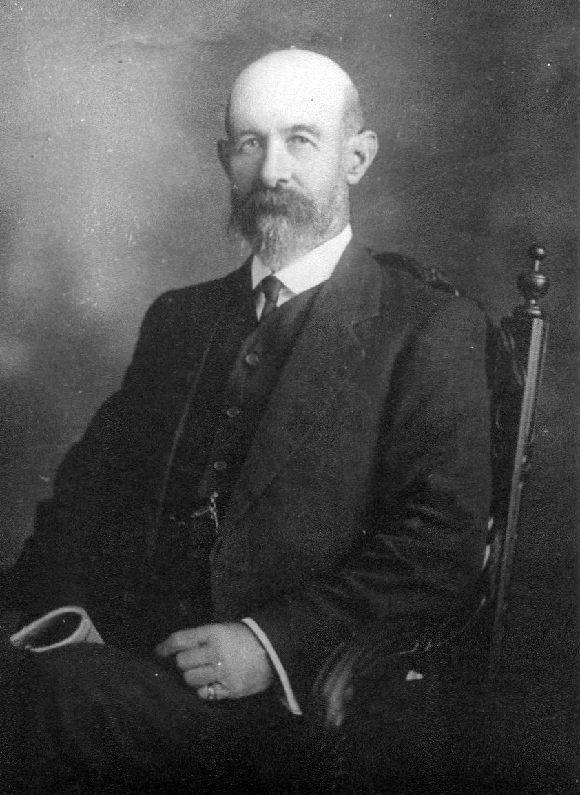
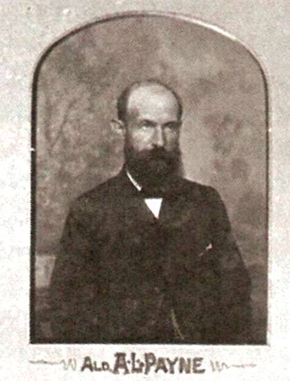
Arthur Lydney Payne was one of Lambton and New Lambton’s most prominent citizens. This month marks 100 years since his death on 15th June 1917.
A L Payne was born at Lydney Park, a property in the Millers Forest area, around 1850. In the 1860s his family moved to Waratah, where the teenage Arthur was employed by the butcher, D McMichael. Arthur’s skill and reliability were so evident that he was soon appointed to the management of the business. In 1870, at just 20 years of age, Arthur Payne purchased a butchering business in Regent St New Lambton, and later that year opened another shop in Elder St Lambton. Thus began a family business that maintained a continuous association with the area until 1993.
A L Payne’s efforts were not only directed towards commerce. He served as an alderman on Lambton Council for 19 years, and was four times elected Mayor. He also became renowned for his expertise in herbal medicines, and “patients came to him for advice from all parts of Australia.”
One of the enduring legacies of Arthur Payne to our district is Le Chalet, the elegant house he had built in Elder St Lambton in the early 1900s. In 1911, at the rear of this property, Arthur Payne erected stables and a buggy house, as he was an avid horseman. He maintained a lifelong interest in the sport of show jumping, and won a number of competitions across NSW with horses he had personally trained. Even a month before his death at age 67 he was active, purchasing a “well-known jumper and show horse” from the Maitland horse markets.
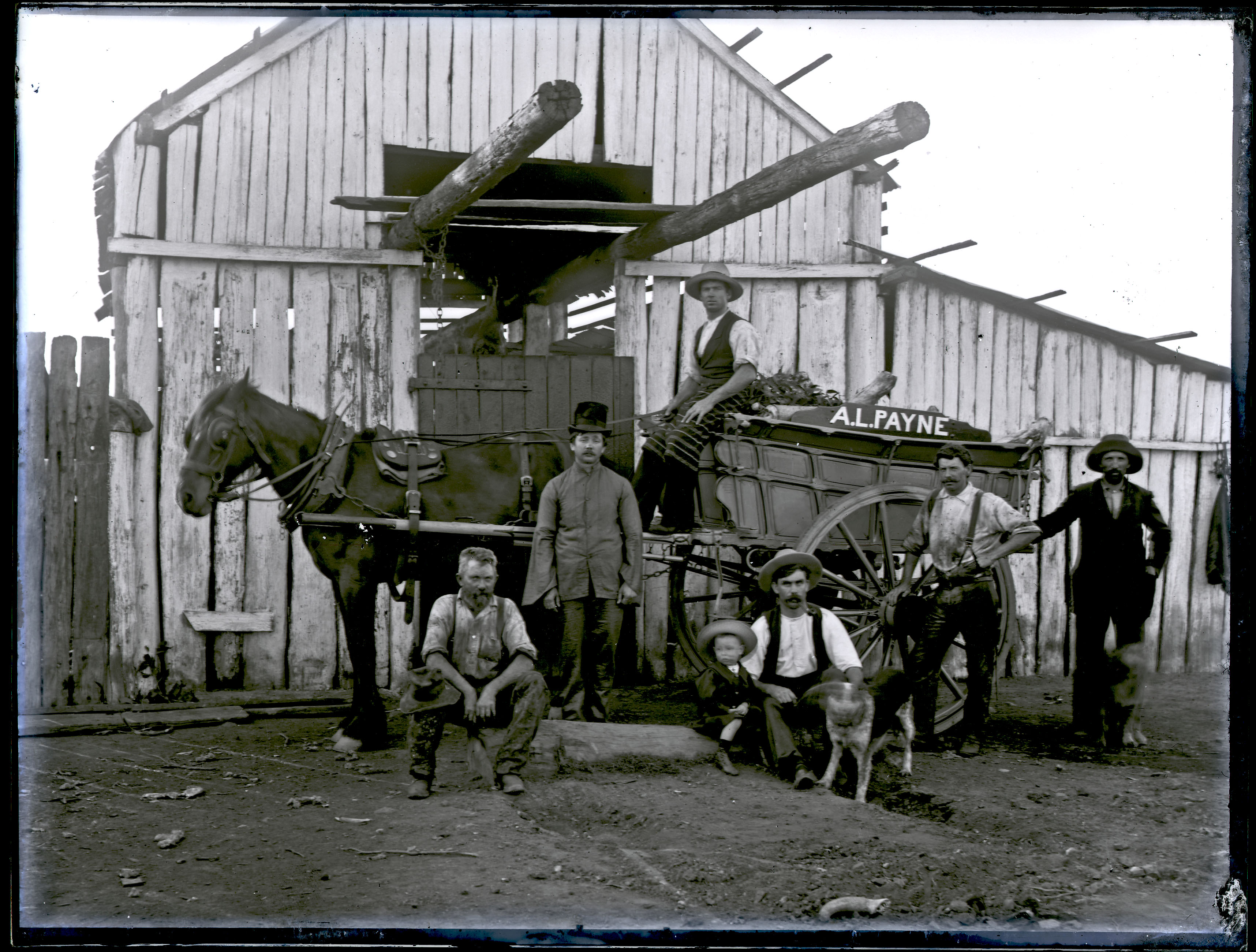
The slaughterhouse that A L Payne established in the 1870s to supply meat to his butcher shops. Exact location uncertain. Photo by Ralph Snowball. University of Newcastle, Living Histories.
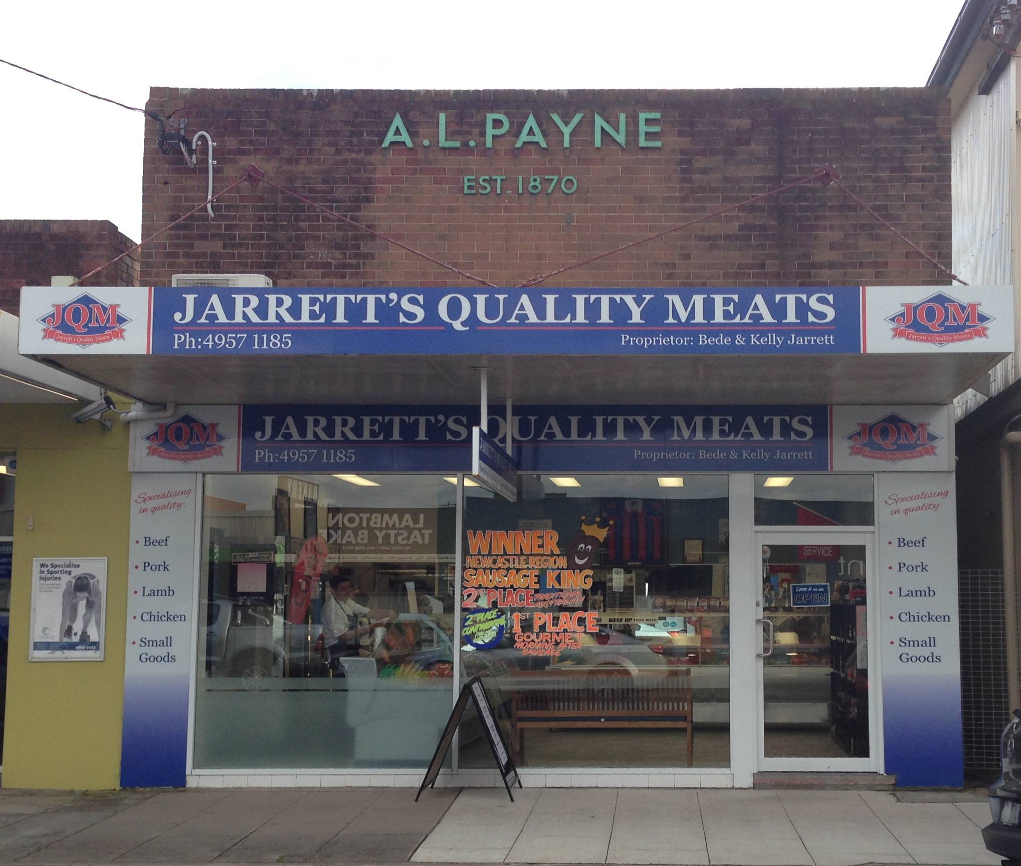
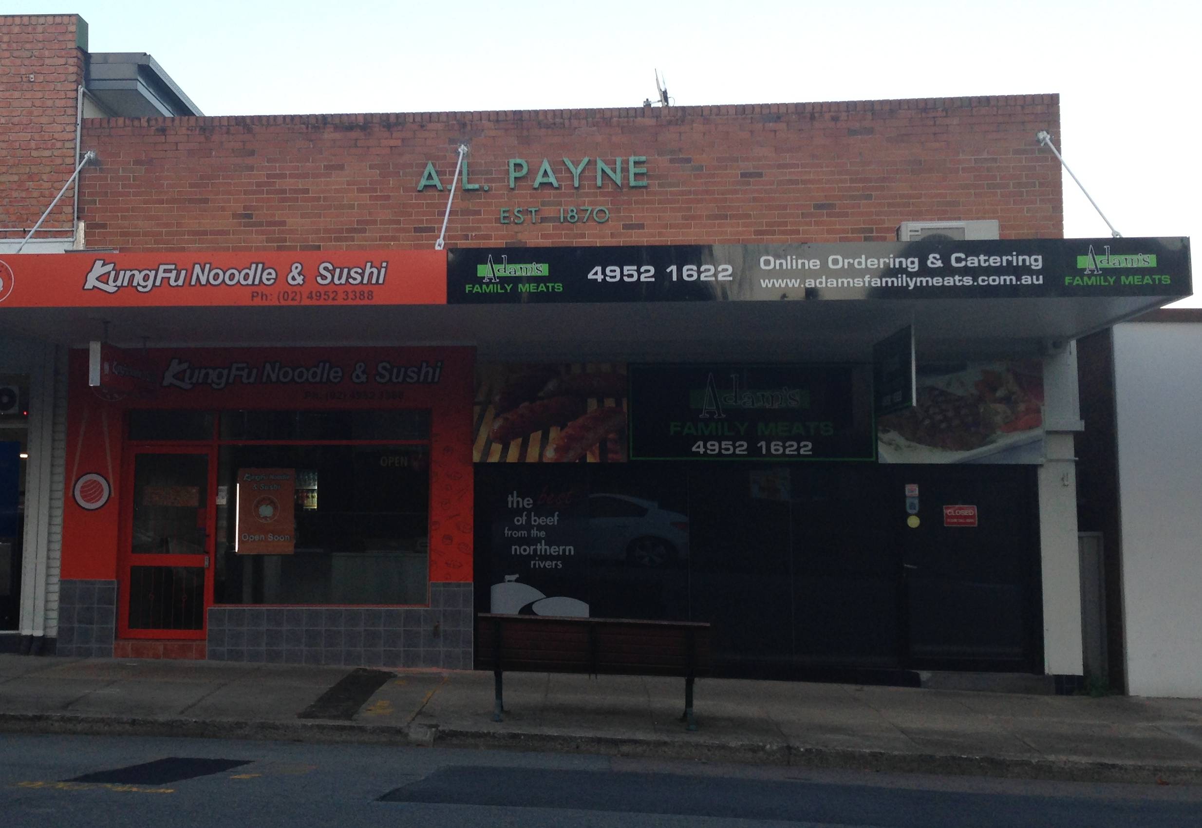
Although not the original building, A L Payne’s former butcher shop on the north side of Elder St Lambton still displays his name, and the year he established his business in the area. 8 May 2017.
The article above was first published in the June 2017 edition of the Lambton & New Lambton Local.
Additional Information
Elder Street buildings
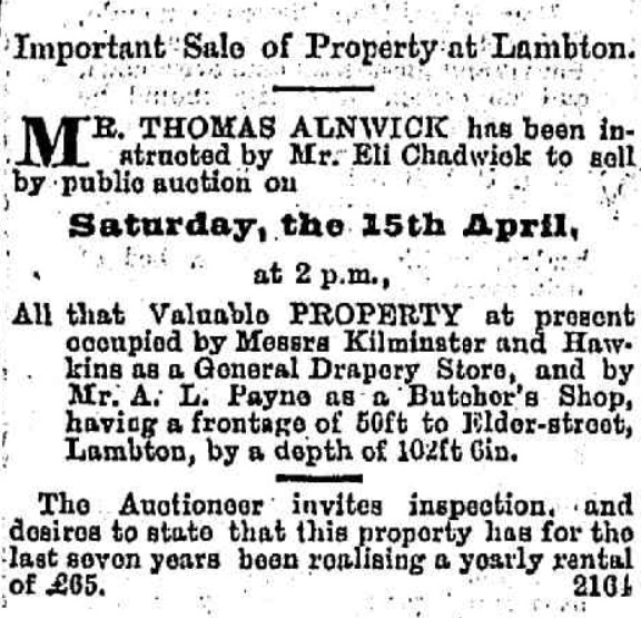
A L Payne’s first butcher shop in Lambton was located on the south side of Elder Street, operating from rented premises, as indicated in the advertisement for the sale of the property to take place in 1882.
Advertisement for sale of property occupied by A L Payne’s butcher shop in Elder St Lambton. Newcastle Morning Herald and Miners’ Advocate, 25 March 1882.
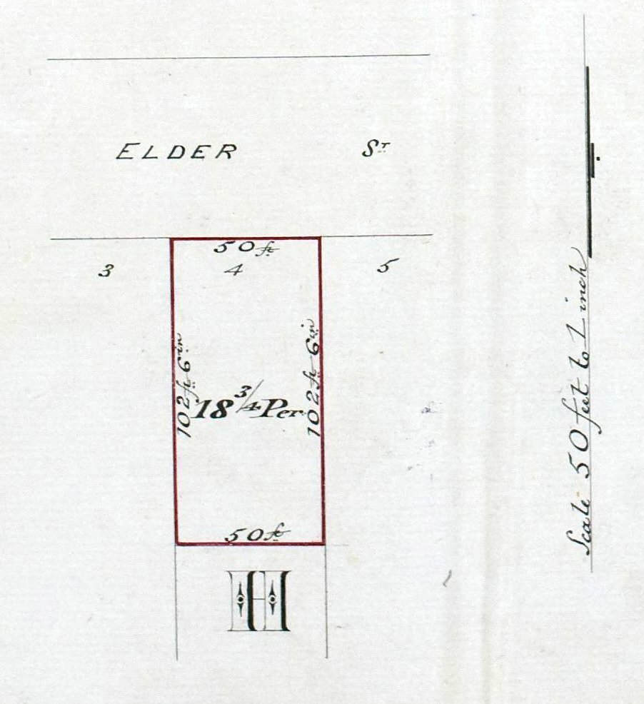
The location of the shop can be identified via this advertisement. Noting that the sale of the property took place on 15 April 1887, inspecting the Land Title records for properties on Elder Street shows only one property changed hands on that date, recorded in Vol-Fol 271-151. Note that the land transfer is from “The Lambton Building and Investment Society Mortgagees Exercising Power of Sale” to “Annie Salmon of Sydney, Spinster.” Eli Chadwick, the person named in the advertisement as initiating the sale, was a director of the Lambton Building and Investment Society.
The property sold was the north half of Lot 4 Section H on the south side of Elder Street. Note that the dimensions of the land match those described in the advertisement.
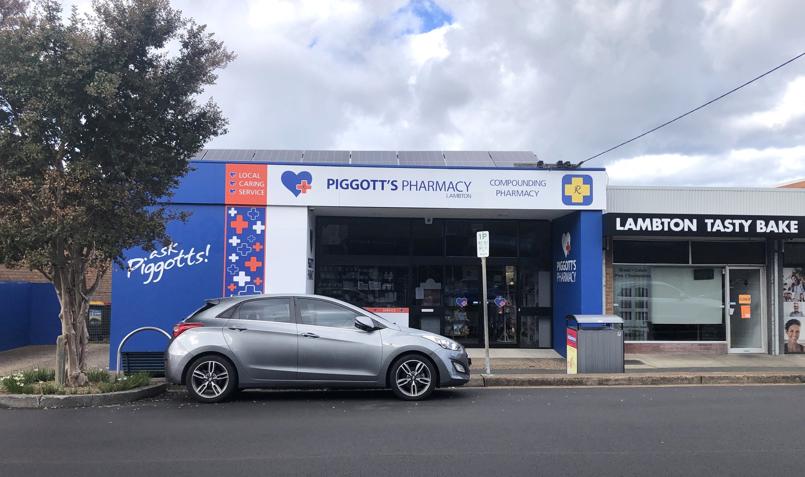
This land corresponds to 105-107 Elder Street today, opposite the current butchers shop, where the pharmacy is located today.
105-107 Elder Street, the site of Payne’s first butcher shop in Lambton, in rented premises.
It is unclear if, or for how long Payne operated a butcher shop at this site after the sale on 15 April 1882. Later that year the paper reported that …
Mr. A. L. Payne is having a large new weatherboard , building erected in Elder-street, part of which, when completed, will be used to carry on the butchering business, and the other part as a boot and shoe store for Mr. W. Sykes.
Newcastle morning herald and Miners’ advocate, 8 September 1882.
Just three years later another report states that …
I notice that Mr. A. L. Payne has commenced the erection of a large two-story weatherboard shop and dwelling-house in Elder-street. The building will contain shop on the ground floor, 29 feet by 24 feet, and five rooms in the upper story. There will be large plate-glass windows, ornamental front, and colonnade, also kitchen, outhouses, store-rooms, and all the requisites for carrying on the business of a general store. When completed the building will rank amongst the most ornamental and useful in the town.
Newcastle morning herald and Miners’ advocate, 16 April 1885.
The location of these two reported buildings is uncertain. The only land Payne owned in Elder St in 1882 and 1885 was Lot 10 of Section F, purchased in 1876. This is 130 Elder St where Payne had a substantial home Le Chalet erected in the early 1900s. It is possible the shops were located on that land.
On 21 March 1887, Arthur Payne purchased Lot 4 of Section E on the north side of Elder Street (106-108 Elder Street today).
Purchase of land on the north side of Elder St by Arthur Lidney (sic) Payne, 21 March 1887. Vol-Fol 97-125.
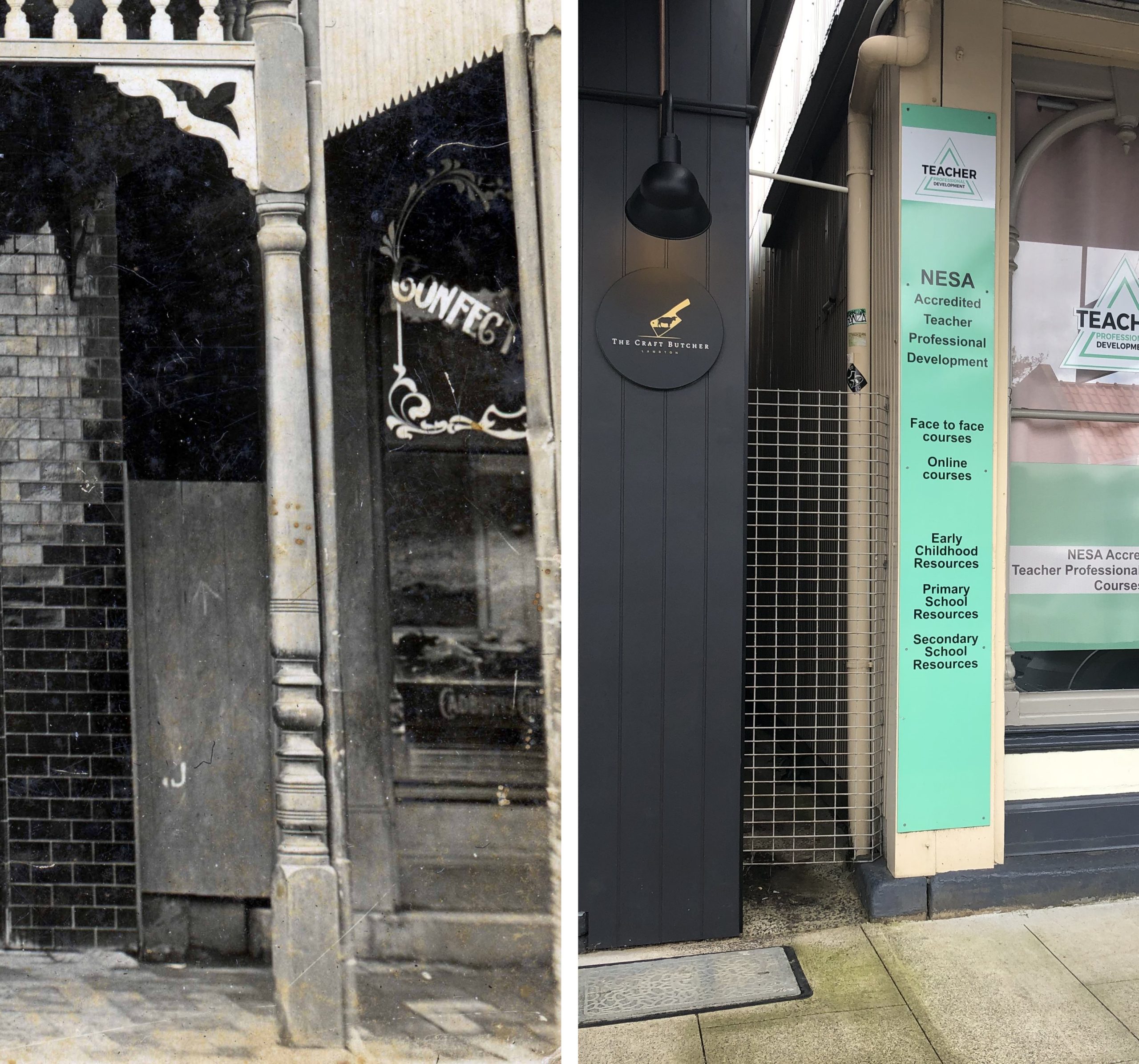
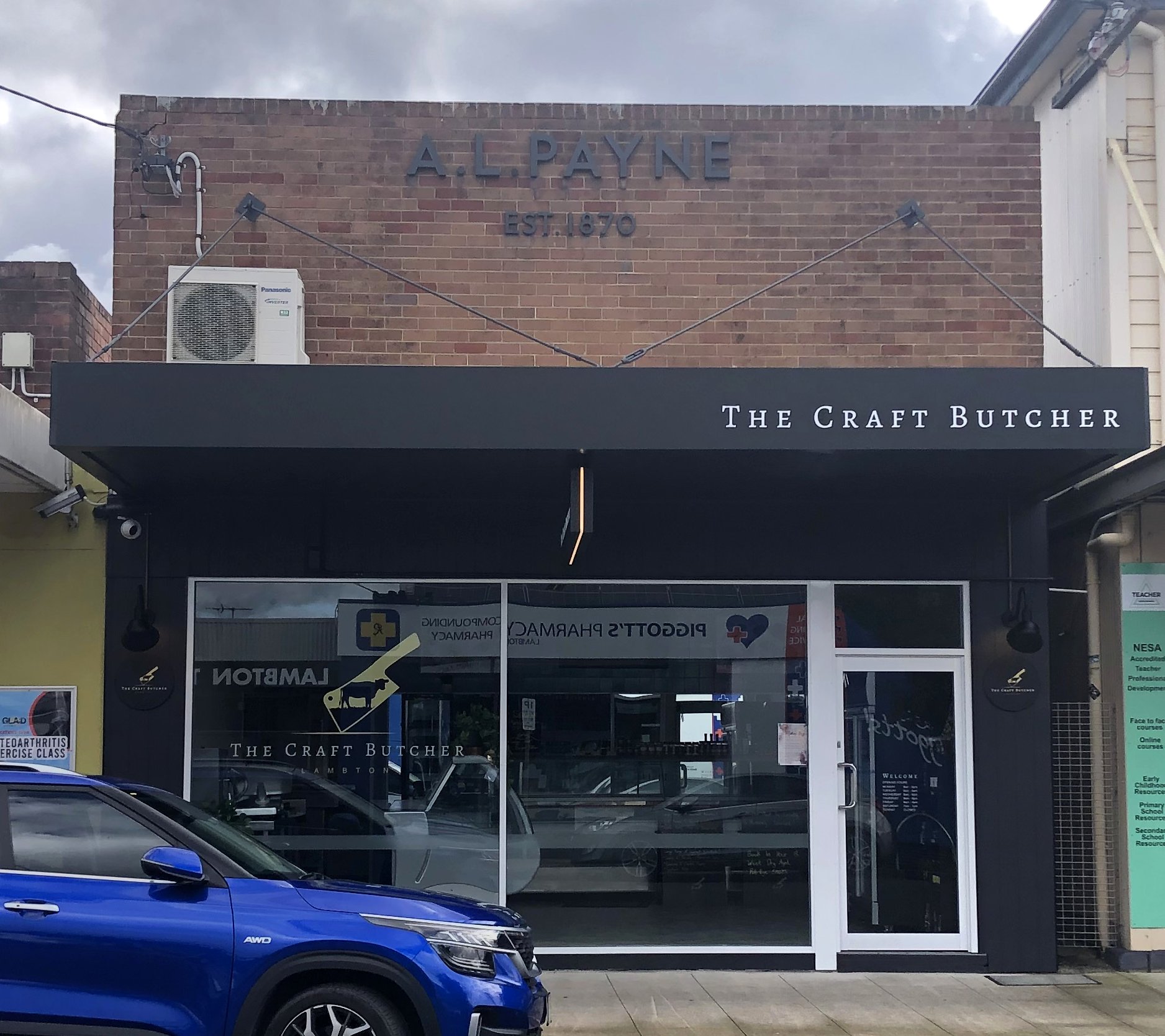
Although page 156 of “The Story of Lambton” says that Payne transferred the butchers business to the opposite side of Elder Street “about 1914”, I suspect that it is more likely that he he conducted his business from the site on the north side of Elder Street soon after he purchased it in 1887. The photograph below shows the original butcher shop on this site. It is not clear whether Payne erected a building after purchasing the site, or if there was already a shop building there. Note that the facade has “Est. 1872” which differs from the current building where the facade has “Est. 1870”. The discrepancy may be due to the first building being erected in 1872 (prior to Payne’s ownership), and the subsequent building with “Est. 1870” referring to the year Payne started his business on the other side of the street.
A L Payne’s butcher shop, north side of Elder St Lambton, circa 1890.
The location of the shop in the photo above can be confirmed by close inspection of the window, woodwork and stonework of the building to the right, which still stands today.
I do not know if the current brick building at 108 Elder Street is a complete rebuild, or a major renovation of the original building, or what year this occurred.
The Craft Butcher, Elder Street Lambton, 23 April 2023.
Other photos
The site of A. L. Payne’s butcher shop in Regent St New Lambton. 28 May 2017.
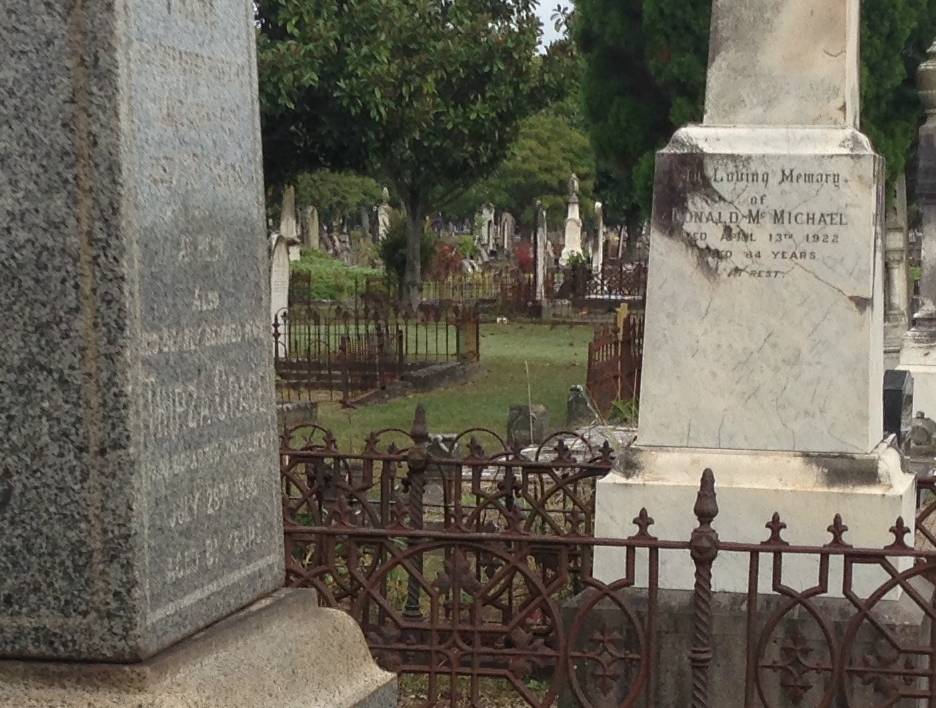
Grave site of Arthur Lydney Payne, Sandgate cemetery.
Inscription on grave monument in Sandgate cemetery. (Contrast enhanced to improve readability.)
"In
loving remembrance
of
ARTHUR LYDNEY
PAYNE
who departed this life
JUNE 15th 1917 a
Aged 67 years.
At Rest
Also
His Dearly Beloved Wife
THIRZA GRACE
who departed this life
July 28th 1936
Aged 81 years"
In a curious coincidence, the grave of Arthur Lydney Payne in Sandgate cemetery is adjacent to that of Donald McMichael, the man who gave Arthur his start in the butchering trade.
There is some uncertainty about the age of A. L. Payne at the time of his death. Page 155 of “The Story of Lambton” states his date of birth as being 8 January 1851, which would make him aged 66 at his death. However the inscription on his grave states his age as being 67. To add to the confusion, the newspaper article reporting his death states that he was born in 1852, which would make him aged 64 or 65.
Lambton Council
Arthur Lydney Payne served as an alderman on Lambton Council for nearly 19 years, in two separate periods of office:
February 1884 to May 1894
September 1903 to March 1912
Interestingly, both periods of office ended with a resignation – in May 1894 over the the failure of the electric light plant, and in March 1912 for an unspecified reason.
Alderman Payne was elected Mayor on four occasions:
At the Maitland horse markets, a month before his death … "We have also to report the sale of the well-known jumper and show horse, Moonbi, at a highly satisfactory price to Mr. A. L. Payne."
"Mr Payne carried on a butchering business successfully for many years, but he was better and far wider known as a skilful adviser in cases of sickness and chronic complaints. He was so successful in the treatment of all kinds of human ailments and diseases that patients came to him from almost all
parts of the Commonwealth, including Queensland and Tasmania."
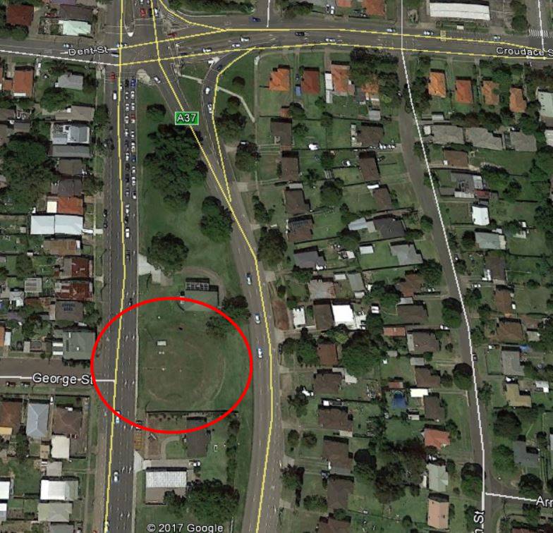
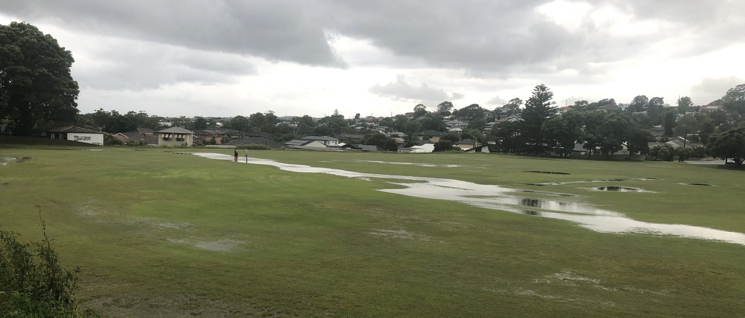
The growth of our city means that former collieries are eventually obliterated by urban development, and it becomes difficult to find any trace of their former existence. Sometimes however, evidence of the old mines can be found, quite literally, under our feet.
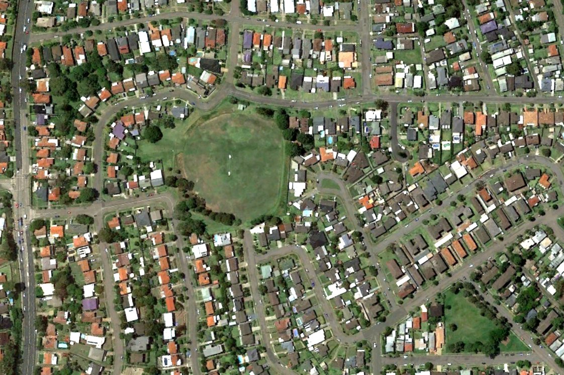
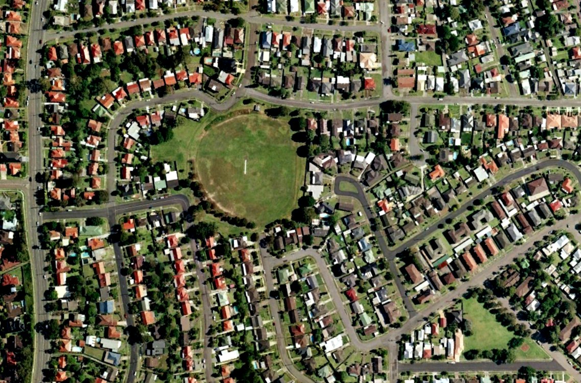
Last year I was walking over Lewis Oval in New Lambton at dusk, when I noticed a slight dip in the level of the ground. I wondered, could this possibly be due to subsidence related to the former Lambton colliery?
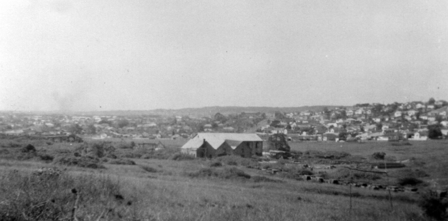
A September 1944 aerial photograph held by Newcastle Library shows that the mine was located at this site. The mine closed in 1936 and much of the surface infrastructure was removed by 1944. The large double storey building in the centre of the photograph housed the colliery’s machinery workshop on the lower floor, and a sawmilling plant on the upper floor. The building got a new lease of life in 1947 when Leonora Glass Industries began operations there.
The railway also continued to be used after the mine’s closure, as noted in a 1942 newspaper article,
“Coal was being hauled by motor-trucks from Cardiff for loading onto the coal waggons near the site of the old colliery screens.”
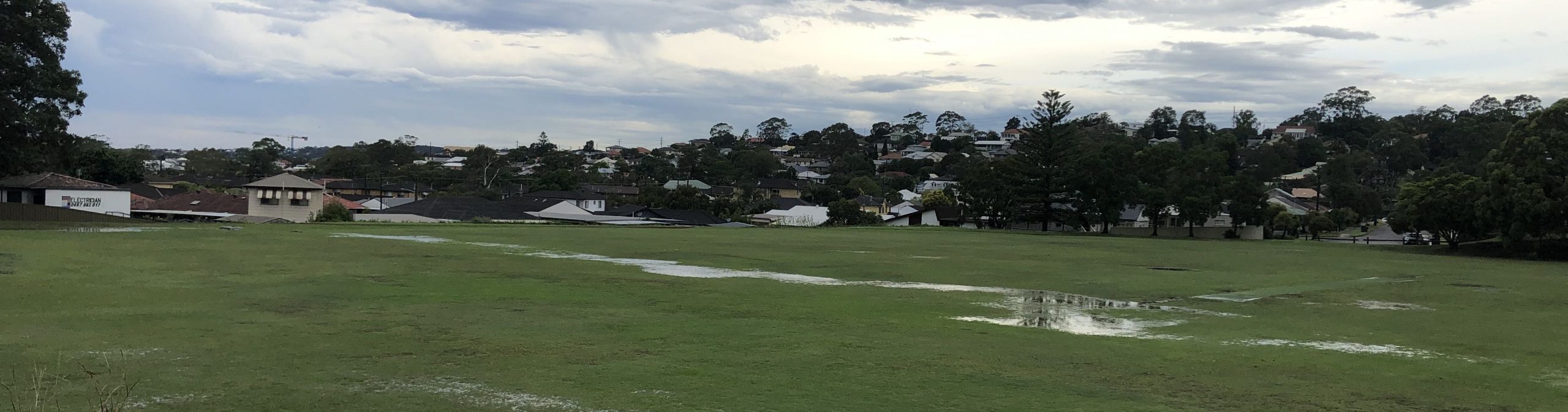
Carting of coal from the site ceased in 1963, the area was developed for housing, and Lewis Oval constructed over the filled in railway cutting. Sixty years on, a slight subsidence of the railway in-fill causes water to collect in the depression. In the right conditions, the grass grows slightly greener, and in some of the modern Google Earth photos, the position of the old railway can still be discerned in a green horizontal line just north of the cricket pitch.
So if you ever find yourself defending the boundary at Lewis Oval, and you notice the outfield seems a little bumpy, you might just be experiencing an enduring impression of our coal mining history.
The Lambton colliery site in 2016. The path of the former rail line can be faintly seen running across Lewis Oval. Google Earth.
The article above was first published in the April 2017 edition of the Lambton & New Lambton Local.
Additional Photos
In this 2006 Google Earth photo, there is a quite distinct darker green line running across Lewis Oval. Google Earth.
Subsidence of Lewis Oval along the line of the former rail excavation revealed after torrential rain, February 2020.
The line of the former railway excavation is revealed again after heavy rain in February 2022.
Lambton Colliery. 1913-1920. The Story of Lambton Extra Photos, page 19. Newcastle Family History Society. From the collection of Dorothy Jones.
The photo above can be dated by the chimney stacks in the distance. The stack of the brickworks at Waratah which was constructed in 1913 is visible, and we can also see the stack of the copper smelter at Broadmeadow, which was demolished by 1920.
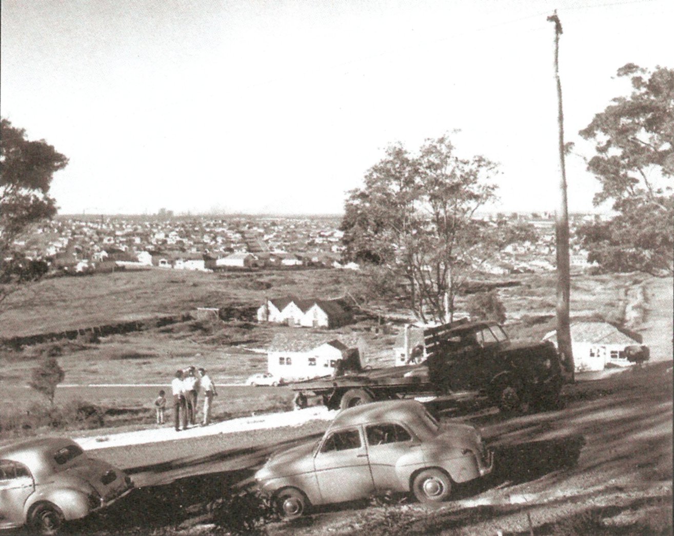
Lambton colliery site, 1951. The Story of Lambton Extra Photos, page 32. Newcastle Family History Society. From the collection of Albert Bates
Lambton Colliery site 1959. The large double storey building where the Leonora Glass Works operated is now gone, destroyed by fire in 1957. The Story of Lambton, p. 19. Newcastle Family History Society. Photo from Stuart Thompson
Additional information
My blog post from February 2016 when I first discovered subsidences in Lewis Oval, marking the path of the former rail line.
If you have Google Earth installed, you can view the 1944 aerial photograph as an overlay by opening this Lambton Colliery (1944 aerial).kmz file.
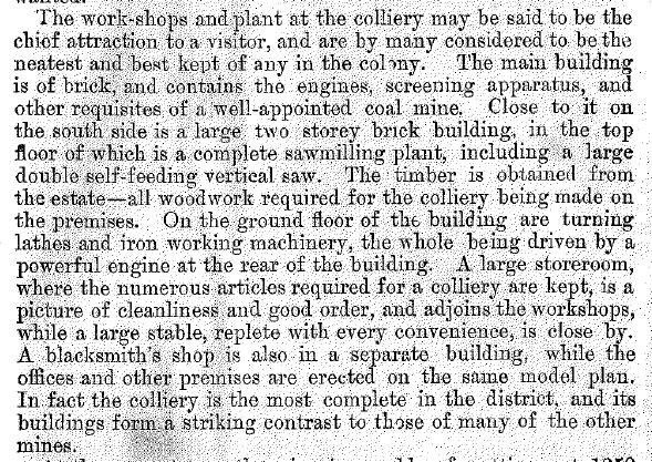
A description of the large double storey building at the Lambton colliery in 1890 can be found on page 15 of “The Coal Mines of Newcastle” by George H. Kingswell. This book has been scanned by the University of Newcastle Special Collections.
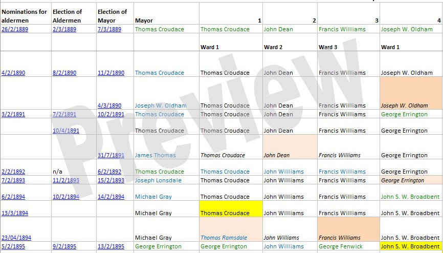
Click the preview image above to view the full table in a PDF document.
Entries in the table that are underlined are hyperlinks to a relevant newspaper article in Trove. To make sense of the information in the summary document, it is helpful to understand how council elections were organised, and how I have used different text and background colours to represent changes in the council membership.
Elections in the New Lambton Municipal Council were initially governed by the NSW Municipalities Act of 1867. The council had 9 aldermen, who served terms of three years.
Initially the municipality was incorporated in 1889 without a ward system, but prior to the 1890 election, in response to a petition from the electors, the municipality was divided into three wards, with three aldermen to represent each ward. Each February the term of three aldermen expired (one from each ward), and nominations were called to fill the expiring positions, so that over a three year cycle the terms of all nine of the aldermen expired. If only one nomination was received for a particular ward, that nominee was automatically elected to the council without the need for a ballot. If there was more than one nomination in a ward the returning officer would set a date within the next seven days at which a ballot would be held, where the ratepayers of the council area would vote for aldermen.
The position of Mayor was not voted on by ratepayers, but rather on the first council meeting after the election, the nine aldermen (including the three newly elected/returned aldermen) would vote for who they wanted to be Mayor. In contrast to the position of aldermen who were elected to a term of three years, the position of Mayor had a term of only one year.
In the event of any casual vacancies, nominations for the vacancy would be called for, and an election called if there were more nominees than vacancies. Casual vacancies in New Lambton were caused by resignation, death, or a shortage of nominees at a scheduled election.
On 26/2/1906, the Municipalities Act (1897) was replaced by the Local Government Act (1906). The system of electing 3 aldermen each year was changed to elect 9 aldermen every 3 years. The election of a Mayor was still held each February, with the Mayoral term running from the first day of March to the last day of February.
In a December 1915 referendum, electors voted to abolish the ward system in New Lambton. Over the years the ward system had produced much dispute and accusations about some aldermen favouring expenditure of money in one ward over another.
Although there are numerous pieces of legislation relevant to local government in the period 1871 to 1938, the main acts relevant to the content on this page are:
In the documents I have used different colours to indicate the means by which people entered and exited council positions:
The foreground text color indicates how a person entered a council position:
Blue indicates the person was elected unopposed.
Green indicates the person was a successful candidate in an election.
Black indicates a continuation in office.
The background colour of a table cell indicates how a person exited a council position:
Yellow indicates a resignation.
Light pink indicates expiration of a term, and the person did not seek re-election.
Darker pink indicates expiration of a term, and the person was defeated when seeking re-election to another term.
Light gray indicates that the person died while serving their term of office.
For entries prior to 1906, where three aldermen retired each year, the names of the retiring aldermen are shown in italics.
Each new row in the table represents a change in the makeup of the council, with the exception of the council/mayoral elections of 1918, 1920, 1932, 1933, 1935, and 1936, where the aldermen and mayor remained unchanged.
Miscellaneous Observations
In the period 1889 to 1938:
27 different people served as Mayor.
The longest serving Mayor was George Errington, who served a total of 7 years as Mayor during the period 1895 to 1914, on five separate occasions.
The following Mayors have streets in New Lambton named after them – Errington, Dunkley, Croudace, Longworth. Alderman Mackie also has a street named in his honour. (Although there is a Marshall St in New Lambton Heights, it was named after James Gordon Marshall, a long time resident of that street, not the James Marshall who was Mayor of New Lambton who lived all his life in Clarence Road New Lambton.)
In comparison with Lambton, New Lambton liked to share the Mayoral honours around. New Lambton council operated for 18 years less than Lambton council, but only had one fewer than Lambton’s 28 Mayors.
Approximately 83 different people served as aldermen.
The exact number is hard to be sure of. I have had to make some educated guesses as to whether aldermen with the same, similar, or variant names at different periods are the same person, or a different person.
There are multiple variations of the spelling for Alderman Dunkley/Dunkeley/Dunckley/Dunckrley over a period 1894-1901. I have assumed it is the same person.
There are two periods of office for William Coomer (1895-1896 and 1908-1913). The obituary of William Coomer in December 1931 states that he “served as an alderman for about four years”, which is suggestive that the 1895-1896 term was held by a different William Coomer. However the article also states that he had been a resident of New Lambton for 45 years, and being aged 74 years at his death in 1931, means that he was in the area and aged 38 years in 1895. So it is quite possible that he did serve the earlier term. In the absence of evidence to the contrary, I have assumed it is the same person.
The longest serving alderman was George Errington who served a total of 26 years and 2 months in the period 1891 to 1920, on four separate occasions.
This page is titled “New Lambton Aldermen“, for they were all men. For most of the life of the council, this was by law, for while both men and women were entitled to vote, the Municipalities Act of 1867 and the Local Government Act of 1906 was explicit in restricting council service to men. e.g. section 69 of the 1906 act says: “Any male person whose name is on the roll of electors for an area shall, if not disqualified, be eligible to be elected and to act as alderman or councillor of the area.” By the time of the Local Government Act of 1919, this gender exclusion for office was no longer in place, however in the remaining 20 years no women were nominated for or elected to New Lambton Council.
Three people died while serving in office, George Fenwick in 1895, Richard Lay in 1903, and George K. Morison in 1927.
There were 24 occasions when an alderman or mayor resigned their position. In most cases the reason was that the person had left the district, or because of ill health, or because other personal matters did not allow them to attend to council business. The biggest combined resignations occurred in 1917, when three aldermen (Milligan, Edden, Lock) having served their three years objected to having their term of office extended by five months by the State Government because of changes to the electoral provisions for voter franchise. A subsequent resignation by Alderman Jordan left the New Council inoperative for a month as there were insufficient aldermen to form a quorum at council meetings.
Real estate advertising that doesn’t align with reality is nothing new. The 1906 poster above shows the promise of neatly laid out roads and residential blocks in the Waratah West region near Christo, Creer and Morpeth roads. However a 1944 aerial photograph of the area I recently obtained from Newcastle Library, shows that 38 years later, there was only Christo Rd and a tiny smattering of houses in the area.
This is confirmed by drawing a line in Google Earth from the obelisk to the peak of the North Lambton hill (seen in the upper left corner of the photo portion above) and noting that the smelter stack is slightly to the right.
"The English and Australian Copper Company, who carry on extensive smelting works in South Australia, are about to establish similar works within a mile of New Lambton.
Construction of the English and Australian copper smelting works at Broadmeadow has been in progress for three months, and smelting "will be commenced in about two months." (This was a wildly optimistic estimate, as smelting eventually commenced in June 1872, more than two years later.)
The manager is "Mr. Christoe, a gentleman of great experience in copper-smelting."
The weather has significantly delayed the opening of the smelter.
"For upwards of two months there was such an accumulation of water at the establishment as to defy the possibility of the works being proceeded with, and thus the company were unexpectedly debarred from carrying out their design in the contemplated time as regards the inauguration of the process of smelting."
250 tons of copper ore have arrived in Newcastle Harbour destined for the New Lambton Copper-smelting Works so "now there is a reasonable hope that this fine and valuable property created here
at a great expense, will very shortly become utilised."
"There appears to be an anomaly existing between our copper- smelting establishments, which time only can set at rest ; for while at this establishment five furnaces are idle for want of ore, at the Hunter River Works, five furnaces are idle here from the want of men acquainted with smelting operations to work them."
Smelting of ore has ceased.
"The business of the company during the past year had to be conducted under conditions of great risk and anxiety, which finally forced the board reluctantly to instruct the manager in Australia to cease making purchases of ore, to smelt out all copper available, and to close the smelting works, a process that has been
carried through."
"The long connection of the English and Australian Copper Company, Limited, with the Newcastle district has been finally severed through its having recently sold the land that was the site of the works, known
as the Waratah works."
When we think of the major contributors to health in our area, the hospital precinct at the top of the hill comes easily to mind. But another important and overlooked contributor lies at the bottom of the hill, in the storm water channels that snake through Lambton and New Lambton. Before they existed the flat expanse of Broadmeadow was a major hindrance in draining rainfall to the sea. An inquiry in 1893 noted that …
“On account of the defective drainage the water lay on the ground for days and weeks and even months in wet weather. It lay about the houses and became a nuisance not only in the way of locomotion, but was also productive of bad health and disease.”
The ill effects of stagnant water included respiratory infections, fungal infections, fevers, and mosquito borne diseases.
Work on the New Lambton branch was halted for several years however, because of a dispute with the Waratah Coal Company whose land the channel traversed. The work was resumed in 1901 and completed soon after. A few extensions in ensuing years resulted in the drainage system that has served us for over a hundred years.
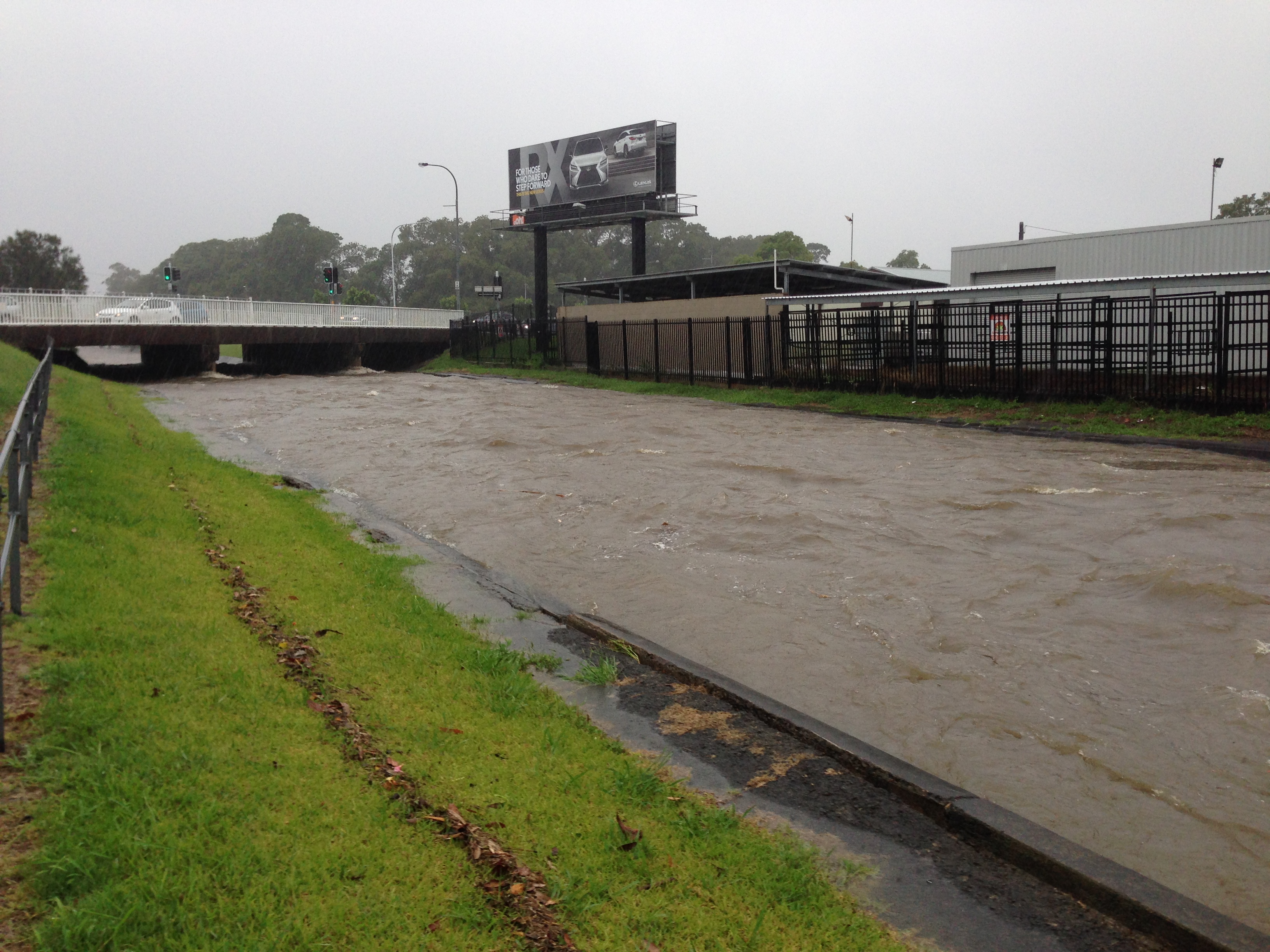
Today, the storm water channel running across Broadmeadow carries away the rainfall from 1700 hectares across eleven suburbs. At full flow it can drain the equivalent of an Olympic swimming pool every 30 seconds. So the next time you think one of those ‘ugly’ open concrete drains, give a bit of respect, and a perhaps drink a toast to the health of the community.
Construction in 1901 of the storm water drain in New Lambton, near present day Mackie Ave. On the horizon, the rightmost hill is where the hospitals would one day be built. Photo by Ralph Snowball. University of Newcastle, Living Histories.
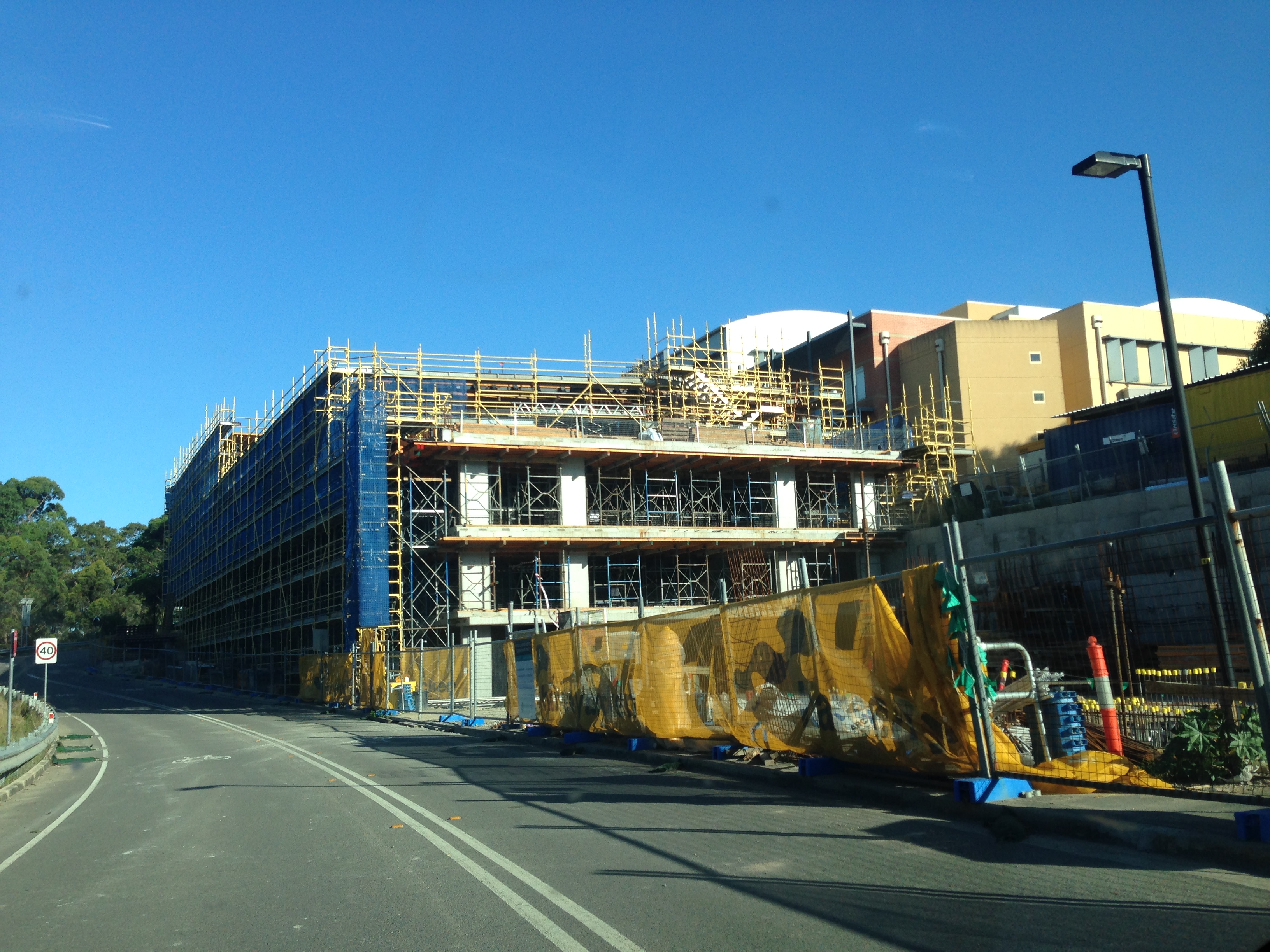
The aerial photograph above shows the early stages of construction of the John Hunter Hospital. The photograph is undated but is probably from 1987, as that is when construction by the McCloy Group began.
The article above was first published in the February 2017 edition of the Lambton & New Lambton Local.
Additional photos
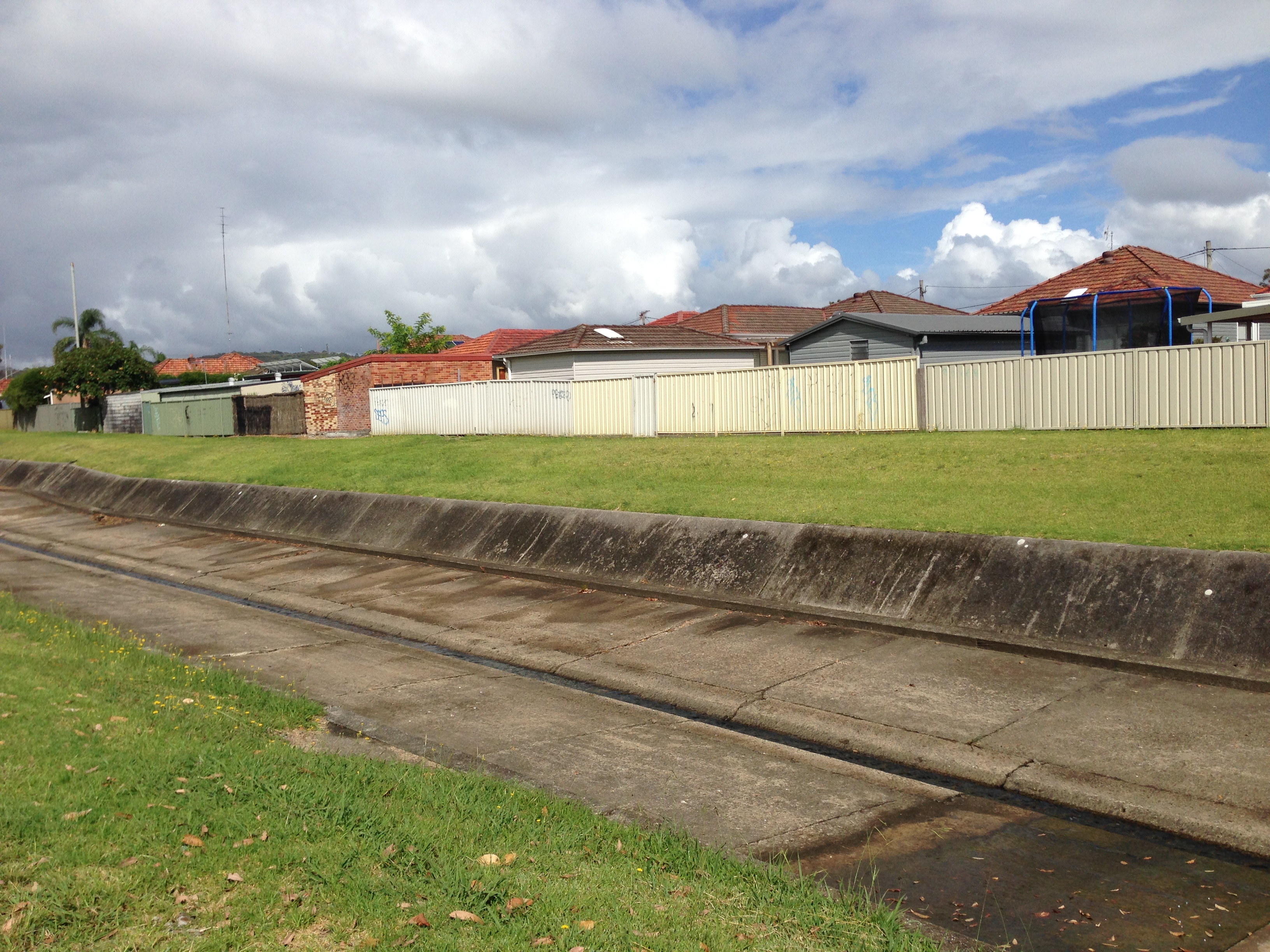
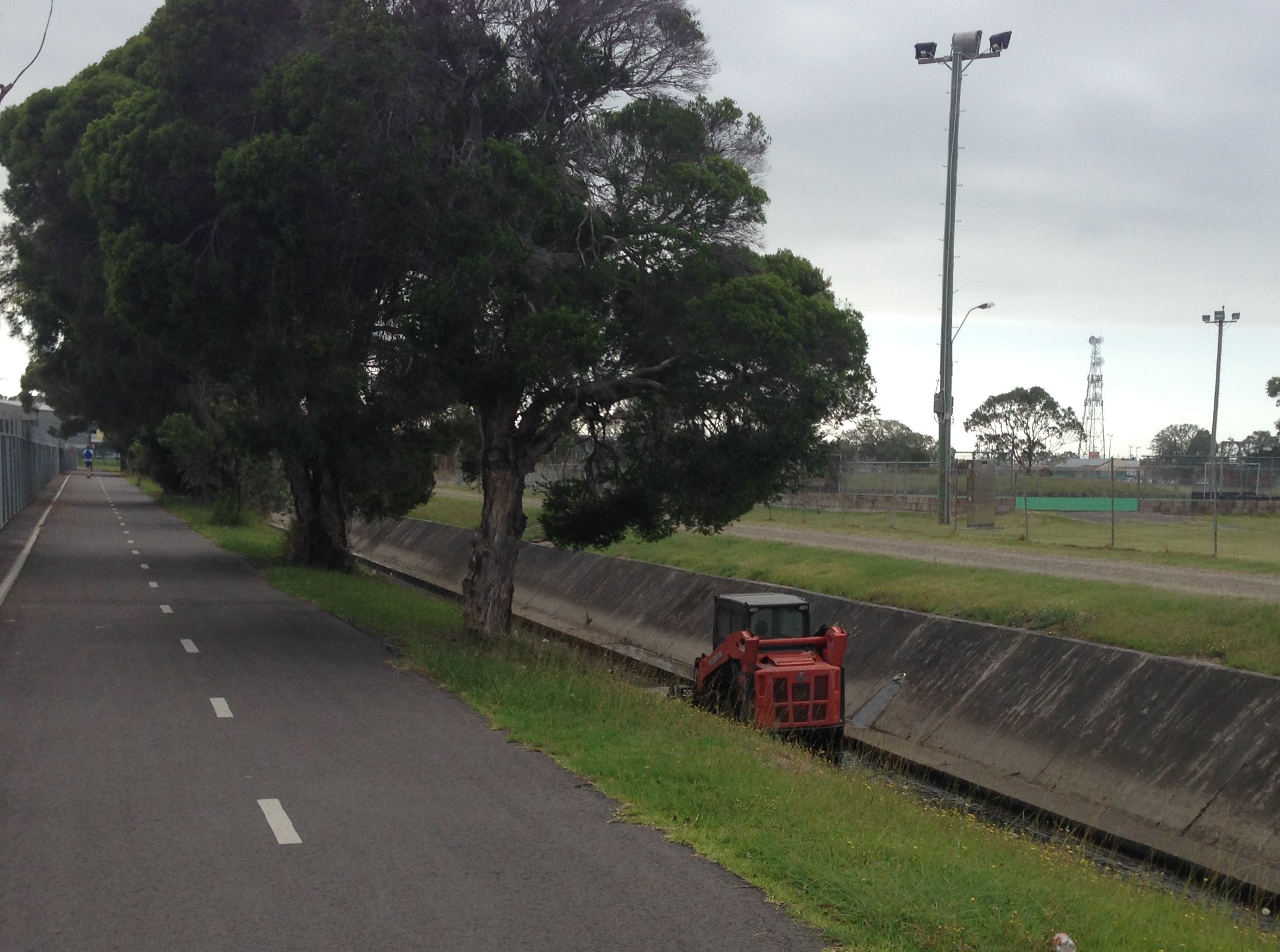
The storm water drain near Mackie Ave, New Lambton, January 2017.
Construction in the hospital precinct, New Lambton Heights, January 2017.
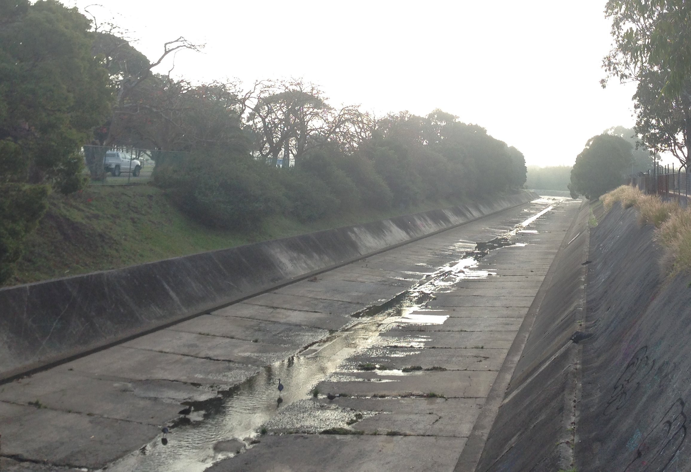
The storm water channel at Broadmeadow in full flow as it passes under Griffiths Road, 5th January 2016.
Acknowledgements
Thanks to local G.P. Doctor Catherine Hollier for medical advice on this story.
In the article I state that “the storm water channel running across Broadmeadow carries away the rainfall from 1700 hectares across eleven suburbs.” To calculate this I used Google Earth Pro and marked out in purple the area that drains into the storm water channel at Hamilton North where Griffiths Road passes over it. (KML download for Google Earth.)
This view from Google Earth shows how the surrounding hills form a half basin with Broadmeadow at the centre. Open storm water channels are marked in yellow, covered storm water channels are marked in red.
1700 hectare catchment area of the Broadmeadow storm water channel.
By using NSW Globe spatial data for Google Earth, I overlaid the suburb boundaries to see that rainfall from the following eleven suburbs drain through Broadmeadow:
North Lambton
Lambton
New Lambton
New Lambton Heights
Kotara
Kotara South
Charlestown
Adamstown Heights
Adamstown
Broadmeadow
Waratah
Rainfall from eleven suburbs drains into the Broadmeadow storm water channel.
The 1900 drain photo
The University of Newcastle Special Collections site has two very similar Ralph Snowball photographs captioned “Drain construction workers at Broadmeadow, NSW, 6 April 1900” (photo 1, photo 2). Given that the paper reported in February 1899 that “the last pick has been driven in the Pasturage Reserve drainage scheme” (apart from the New Lambton branch), it raises the question as to whether the location and date on these photos is correct.
Regarding the location of the photo we can see that the water in the drain is flowing left to right, and with the hills in the background it is clear that the photograph is taken from the eastern side of the drain, looking towards the west. An important clue is the large smoke stack behind the pile of dirt – this is almost certainly the stack of the English and Australian Copper Smelting Company, located in Broadmeadow, where UGL Limited (formerly Goninans) is now located.
1910 Barrett map overlaid on Google Earth, showing the location of the copper smelter near Waratah.
Along the hill in the background we can see what I believe to be Russell Road, New Lambton.
Russell Rd, New Lambton.
Towards the top of Russell Road there is a house with a dark line in front of it.
I believe that this is Hunter P Brett’s residence with a dark fence in front of it, as shown below in a 1908 photograph. This house still exists today, at 168 Russell Road.
With two points in the background of the 1900 drain photo established, the range of possible locations for the photo are narrowed down to the yellow shaded area below, that is between Broadmeadow Rd and where the drain passes under the railway at Islington.
Possible location of 1900 drain photo marked with yellow shading.
Its difficult to be certain, but the angles in the photo suggest that it was probably taken from Hamilton North, somewhere near the old gasworks site.
Corroborating this location is a newspaper report on 30 April 1900 “concerning the death of a middle-aged man named Michael Powell, who, in the forenoon was accidentally killed by a fall of earth at the storm-water drain at Newtown, near Hamilton.” Newtown was the original name of Hamilton North.
It is somewhat sobering to realise that it is quite possible that Michael Powell is one of the men in the 6th April 1900 photograph, just weeks before he was killed in a workplace accident at that site.
Having established with reasonable certainty that the photo location is Hamilton North, the question remains as to what work was being done on the storm water drain there, as work was supposedly finished a year earlier. Possibly the drain at that point needed to be widened, deepened, or strengthened to handle the increased flows resulting from the addition of the New Lambton, Adamstown and Hamilton branches of the drainage system.
Tony Steinbeck helpfully pointed out to me that the tall structure on the far bank appears to be a pile driving tower, used to drive foundations into the ground.
Pile driving tower
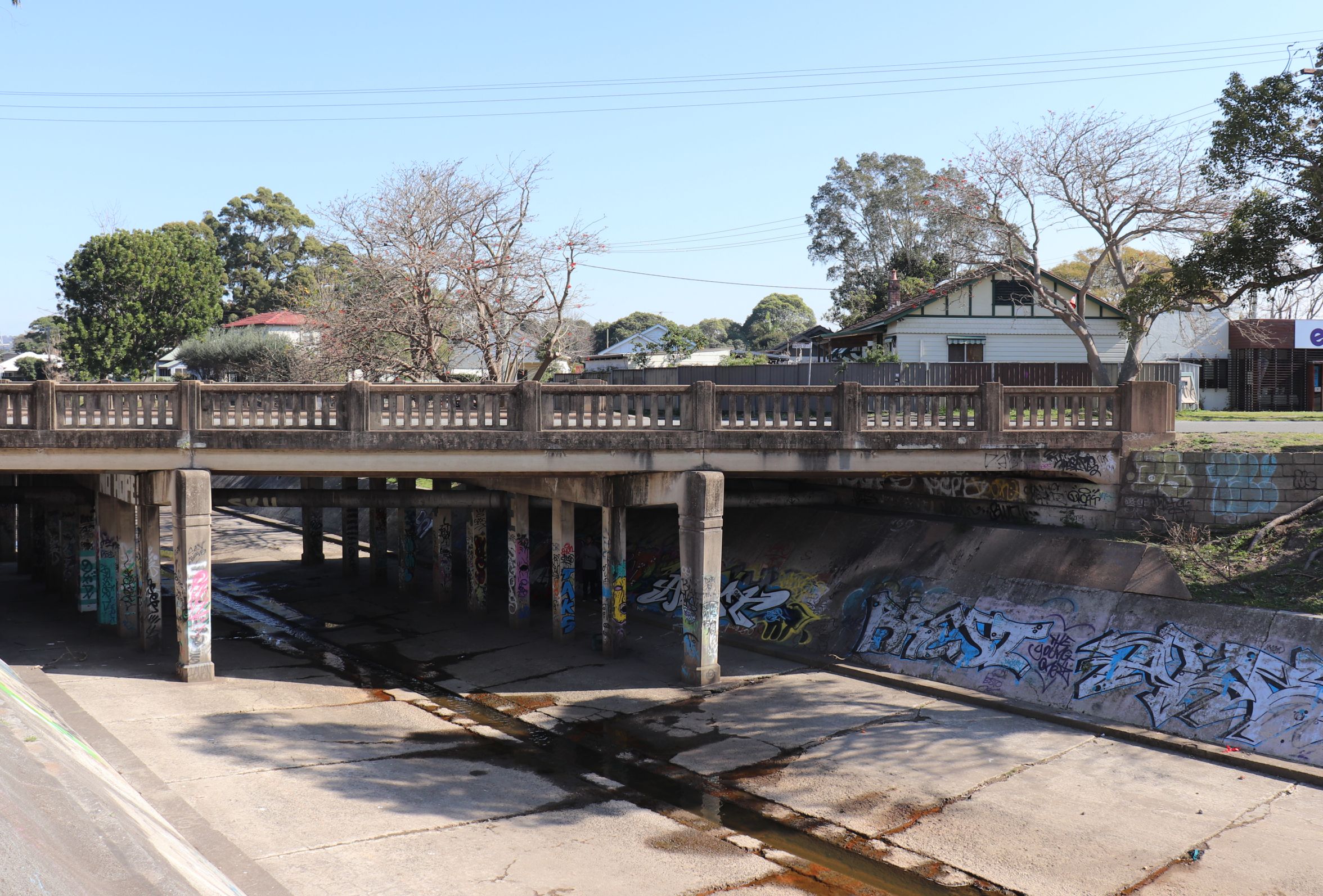
The obvious candidate in the Hamilton North area that would require foundations alongside the drain is the Chatham Road bridge. So the photo from 1900 is possibly showing construction of an earlier bridge across the drain. The current bridge has no plaque indicating a date of construction, just an an empty spot with sawn off bolts where the plaque would have been placed. However the Chatham Rd bridge is of similar construction to the Broadmeadow Rd bridge which was opened in 1957.
Chatham Rd bridge over the storm water drain in Hamilton North. July 2018.
Creatures in the drain
The storm-water channel is not only good for humans – all sorts of creatures can be found there.
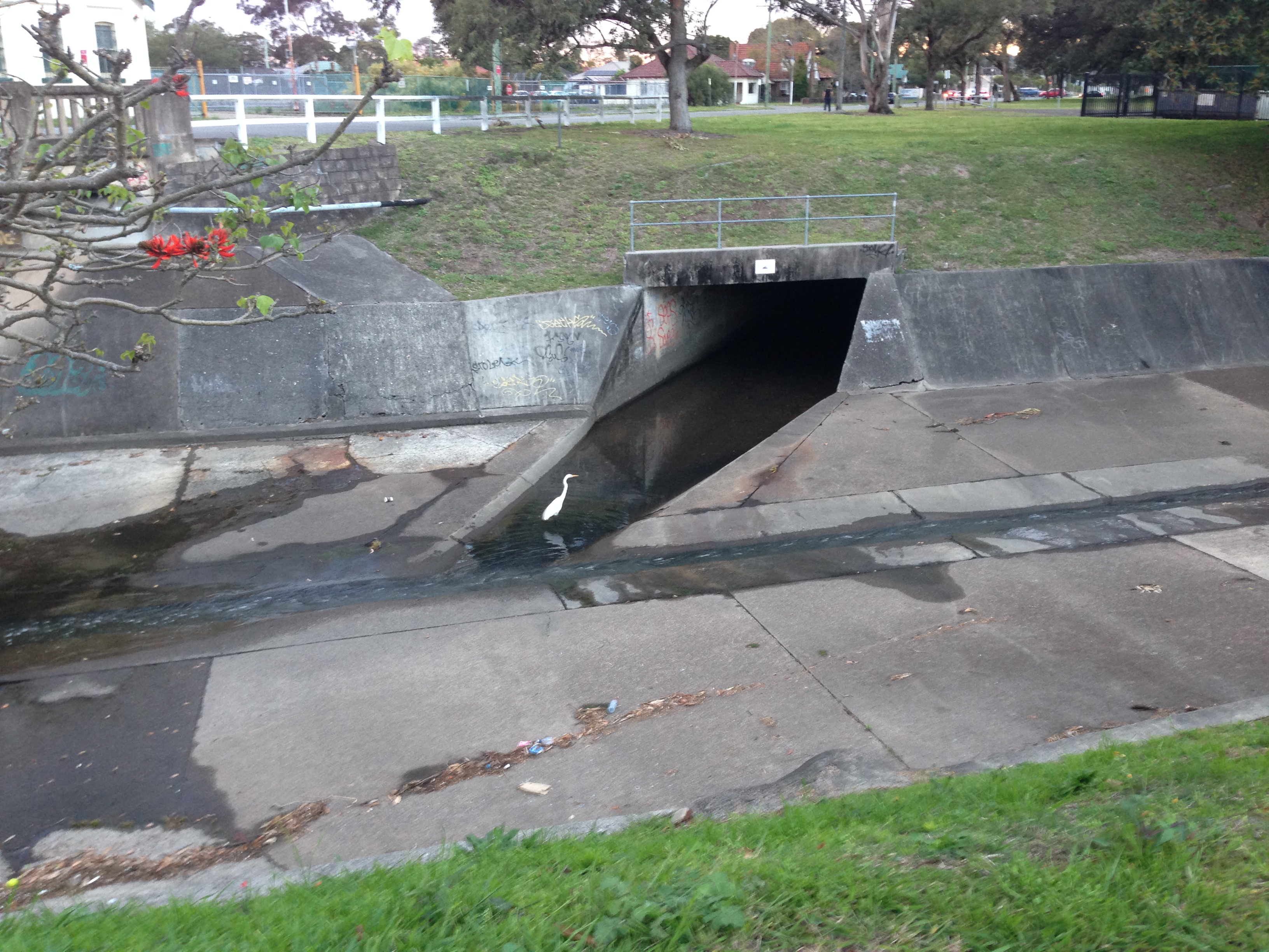
Egret in the drain at Hamilton North.
Egrets in the drain at Hamilton North on a misty winter’s morning.
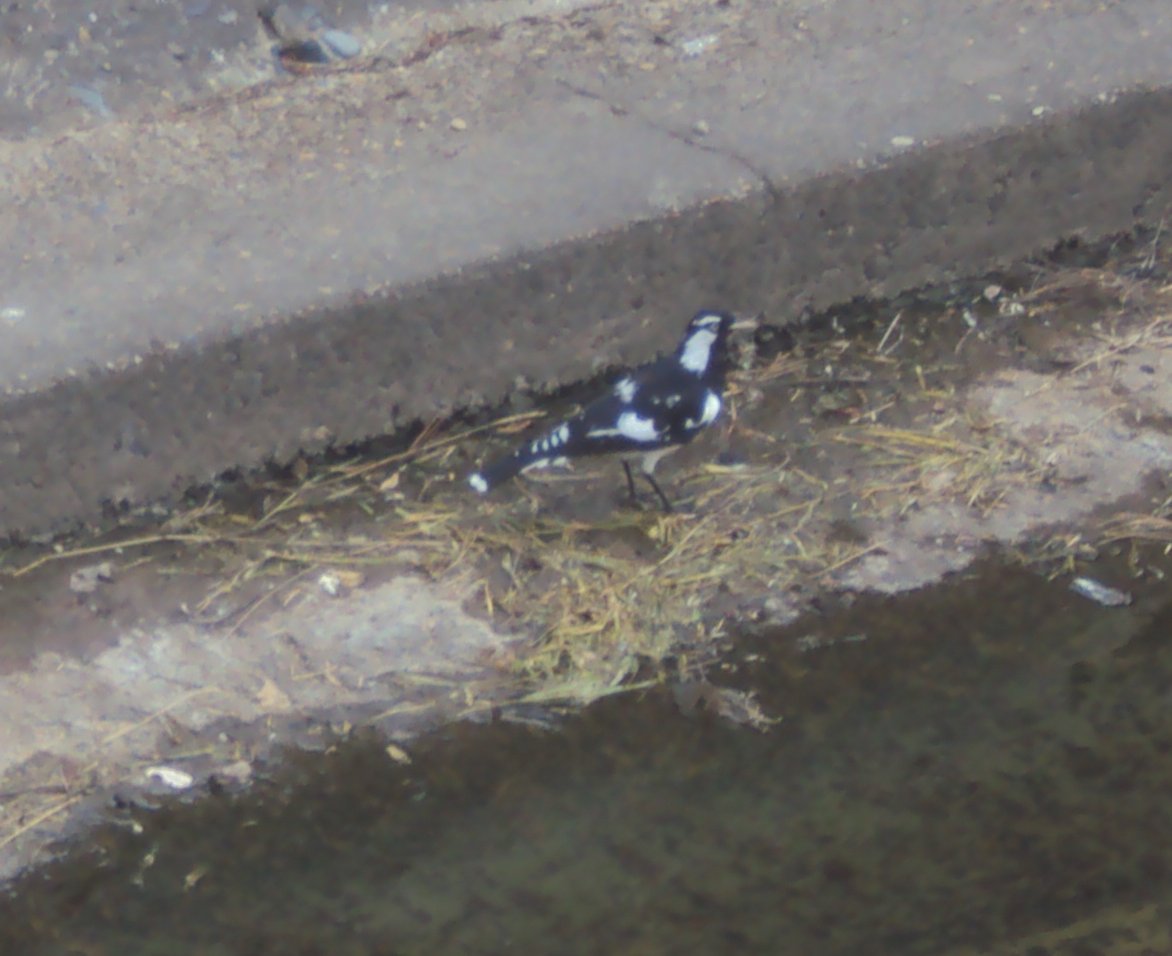
Bird in the drain
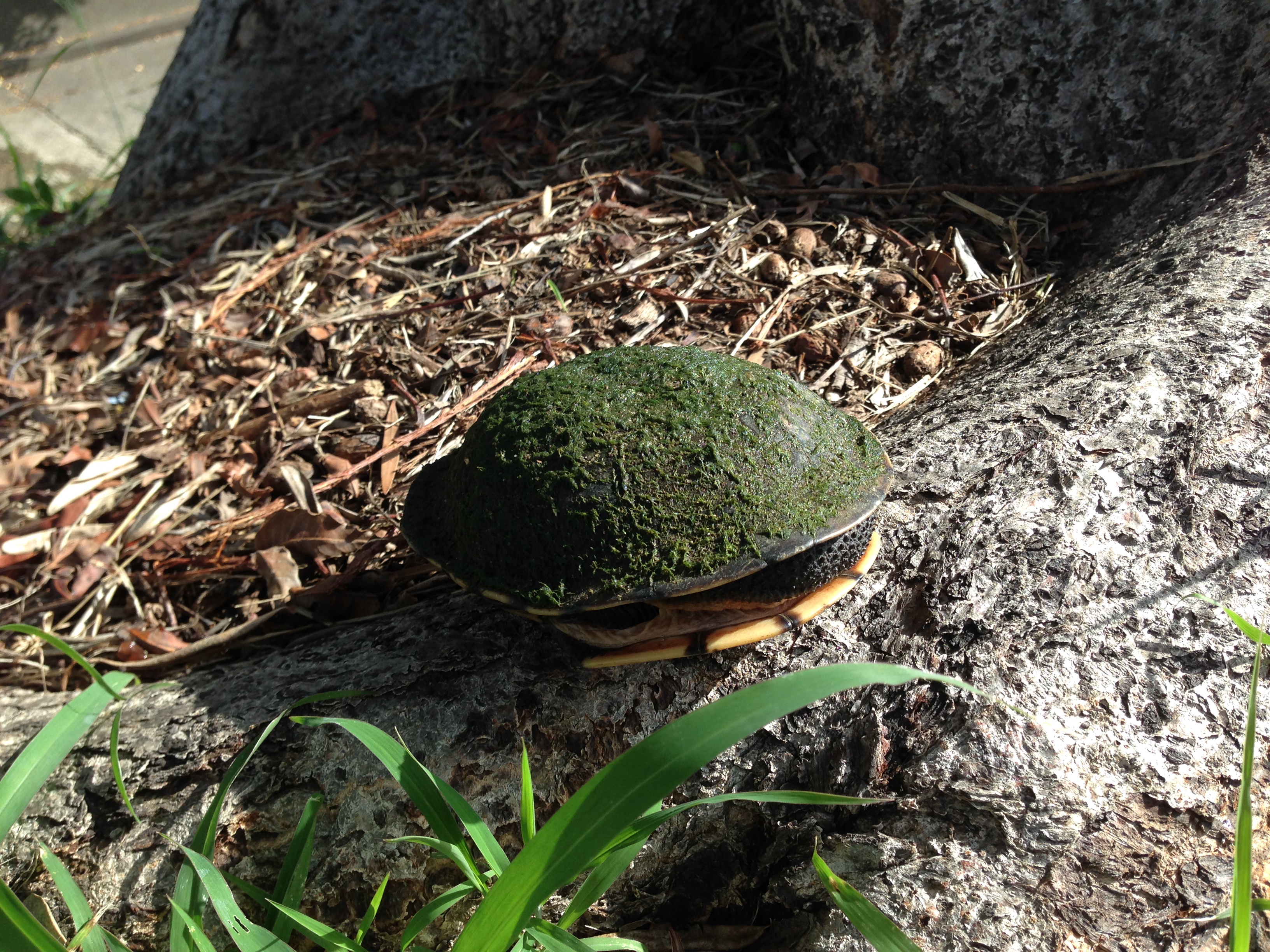
Tortoise found near storm water drain in Hamilton North.
A mechanical creature of the drain.
Other drain things
Probably the strangest thing I’ve spotted in the drain is my own letterbox. In October 2019 our letterbox mysteriously disappeared one night. The next day, cycling home from work through New Lambton Park, near Ford Oval I glanced down and spotted my letterbox – dumped in the drain over one kilometre from my home. It was broken into multiple pieces, but I managed to retrieve, repair, and reinstall it.
Links
In February 2016 I wrote a longish blog post about the drainage system, where, amongst other things, I calculated how fast the drain could empty an Olympic swimming pool.
"The recent rains have proved the drainage of Lambton to be very defective … there is nothing so injurious to the public health as bad drainage, to say nothing of the damage done to property by flood water."
Mr Griffiths, in nominating for New Lambton council promises that he would work to "prevent fevers and the like by strict attention to the drainage, and he would advocate co-operation with other Councils for
a general system of drainage."
"A thorough system of drainage at the lower end of the district from New Lambton downwards, through Hamilton, is necessary to prevent these periodical floods, as the water then would have an opportunity of
free access to the main channels to the sea."
New Lambton Council - A decision about making another watercourse through the New Lambton railway embankment, is held over pending the result of the deliberations on the proposed combined councils' drainage scheme along the Australasian railway.
Call for the government to keep its promise to drain the Commonage. The lack of drainage meant that "in very wet weather the low-lying portions present the appearance of miniature lakes, in which the small houses of the residents appear like islands."
Hamilton council receive a letter from the Public Works Department regarding "the drainage scheme on the Commonage, stating that the survey had been completed, but that fully three months must elapse before the plans and estimate could be prepared."
The survey of the drainage scheme has been completed. "It is proposed to make the main trunk 50ft wide and 8ft deep, and to extend it from the Great Northern railway line past the Raspberry Gully line, a distance of about three-quarters of a mile."
Call for workers on the drainage scheme.
"GANGERS are requested to meet the undersigned at intersection of Broadmeadow and old Australasia line at 3 o'clock THIS (Monday) AFTERNOON,for the purpose of cavilling for sections of work to be done. H. D. WALSH, District Engineer."
Work commences on the drainage scheme. "The drainage works at Broadmeadow presented an animated appearance yesterday, upwards of 100 men being at work and quite double that number looking on."
Drainage works progressing. "The section now open extends from behind Kidd's boot factory, at Islington, or to be more explicit, from Styx Creek, six chains below the Newtown Bridge, along the old Australasian Company's railway to the Broadmeadow Lambton road, at the New Lambton railway. The distance is just on two miles, and when completed the drain will be as straight as a gun barrel over its first section."
"The work of completing the lining of the drain on the Lambton Park does not form part
of the Pasturage Reserve drainage scheme, and that no funds were available for that purpose."
"By the aid of two powerful steam pumps running day and night, the drainage from Lambton,
Adamstown, Mayfield, Waratah, and the surrounding suburbs, has been pumped out of the channel. This allows a larger number of men to be employed than formerly, and at present about 200 men, with horses and drays, are working perfectly dry at a level of 7ft below high water mark at Nobbys."
Drain is being extended up to Lambton Park. A tributary channel from Gregson Park Hamilton will soon be commenced. Tighes Hill footbridge nearly completed.
"At the beginning of the week 120 men were put on at the Lambton extension, which is to cover
a distance of a quarter of a mile." Estimated Expenditure on the drainage scheme is £39,500.
Work on the New Lambton section of the drainage channel has been suspended and 230 men thrown out of work. "The Government failed to resume the land before cutting the drain, believing that property-owners would only be too glad to have their land improved in value by means of the drainage. The Waratah
Company, however, take the view that the soil excavated in their estate should not be scattered over the grass, but should be taken away. The Government at present refuse to do this."
"The Lambton branch, costing £3600, is now nearing completion, less than 20 men being now employed upon it."
A dispute between the Government and the Waratah Coal Company "has resulted in the suspension of operations on the New Lambton branch of the main channel of the Pasturage Reserve drainage scheme."
Regarding the five month suspension of work on the New Lambton Channel, the Waratah Coal Company is not being co-operative, and the Government is forced to compulsorily resume the land.
"The last pick has been driven in the Pasturage Reserve drainage scheme, which was commenced some three years ago. There remains the New Lambton branch of the main channel to be completed, but, in
view of the opposition of the Waratah Coal Company, this extension seems to have been abandoned."
Prospects that work on the New Lambton branch of the storm water channel might recommence soon. A new survey for the branch channel has been made, so that instead of "the channel being constructed in a direct line it will take a sweep and miss the private property."
The importance of the drainage works is again emphasised for "on it depends to a great extent the health of the people of that locality. Typhoid fever made its appearance in that neighbourhood recently, and the cause could only be attributed to the want of drainage, for the majority of dwellings are damp."
The government is trying to pass off control (and the mainentance cost) of the stormwater channel to either the Hunter District Water and Sewerage Board, and/or the local councils. Neither are very happy with being saddled with the cost.
The Hunter Living Histories site has just published an article on Robert Perrott, including some sketches he did of various places around Newcastle in the late 1800s. Of particular interest is a sketch of the copper smelting works near Waratah.
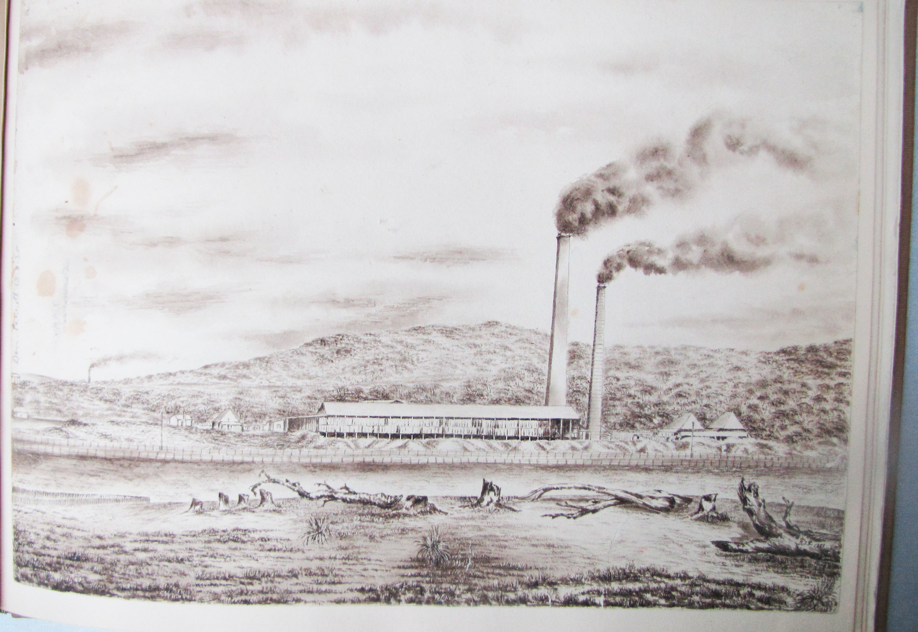
Copper smelting near Waratah, at Newcastle. (Sketch by Robert Perrott, Mitchell Library, State Library of NSW)
This was the works of the English and Australian Copper Smelting Company, which commenced operation in 1872. The Maitland Mercury reported on 18 June 1872 …
On Tuesday last a very interesting ceremony was performed by the Mayor of Waratah in the presence of the local manager of the establishment and a few gentlemen from Newcastle, namely, that of lighting the first fires in two of the copper smelting furnaces of the English and Australian Copper Smelting Company’s works near Waratah.
The smelter operated for about 47 years, and the land was sold off in 1918 and 1919, as reported by the Maitland Mercury on 6 Nov 1919.
A 1910 map by A. Barrett shows that the smelter was situated in modern day Broadmeadow, where UGL Limited (formerly Goninans) is now located.
1910 Barrett map overlaid on Google Earth, showing the location of the copper smelter near Waratah.
The smelter had two large brick smokestacks, that were highly visible points in the landscape, and often appeared in the background of photographs of the time.
Stormwater drain construction at Hamilton North., April 1900, looking towards New Lambton. The Waratah copper smelter stack is visible in the background. University of Newcastle, Living Histories.
An interesting aspect of the Perrott sketch of the smelter, is how some details are quite accurate, but other details not so accurate, probably for aesthetic reasons. When we compare the sketch with a 1906 Ralph Snowball photograph of Waratah taken from somewhere near the present day Mater hospital, we see that Perrott has reproduced the smelter building and stacks reasonably accurately. However in the sketch the smelter appears to be at the base of a hill, but the smelter was actually located on the flat plain of Broadmeadow, and that hill is Merewether Heights some 4km in the distance.
Sketch of Waratah copper smelter by Robert Perrott.
"The English and Australian Copper Company, who carry on extensive smelting works in South Australia, are about to establish similar works within a mile of New Lambton.
Construction of the English and Australian copper smelting works at Broadmeadow has been in progress for three months, and smelting "will be commenced in about two months." (This was a wildly optimistic estimate, as smelting eventually commenced in June 1872, more than two years later.)
The manager is "Mr. Christoe, a gentleman of great experience in copper-smelting."
The weather has significantly delayed the opening of the smelter.
"For upwards of two months there was such an accumulation of water at the establishment as to defy the possibility of the works being proceeded with, and thus the company were unexpectedly debarred from carrying out their design in the contemplated time as regards the inauguration of the process of smelting."
250 tons of copper ore have arrived in Newcastle Harbour destined for the New Lambton Copper-smelting Works so "now there is a reasonable hope that this fine and valuable property created here
at a great expense, will very shortly become utilised."
"There appears to be an anomaly existing between our copper- smelting establishments, which time only can set at rest ; for while at this establishment five furnaces are idle for want of ore, at the Hunter River Works, five furnaces are idle here from the want of men acquainted with smelting operations to work them."
Smelting of ore has ceased.
"The business of the company during the past year had to be conducted under conditions of great risk and anxiety, which finally forced the board reluctantly to instruct the manager in Australia to cease making purchases of ore, to smelt out all copper available, and to close the smelting works, a process that has been
carried through."
"The long connection of the English and Australian Copper Company, Limited, with the Newcastle district has been finally severed through its having recently sold the land that was the site of the works, known
as the Waratah works."