Hanbury was a private town at Waratah in the area bounded by Turton Road, High Street, Bridge Street, and Platt Street.
In 1831 the governor of the colony Sir Ralph Darling promised a grant of 60 acres of land near Waratah to George Dent, and sometime later the promised grant was transferred to Simon Kemp and his wife. On 13 October 1843 Thomas Grove purchased the right to the land from Kemp, and on 30 April 1844 the government confirmed the grant to Thomas Grove with a Quit-Rent price (a nominal rent) of 10 shillings per annum. (Ser-Pg 61-182)
Schedule on page 3 of title deed Bk-No 81-870 with the dates of Conveyance and Grant.
Promised by Sir Ralph Darling, on the 25th May, 1831, to Mr. George Dent, and possession ordered on the 27th January, 1832, as a small grant Dent has transferred his interest to Mr. Simon Kemp, who requests the Deeds to issue in favour of Mr. Grove. Quit-rent 10s. per annum, commencing 1st January, 1839.
In October, 1843, this 60 acre block was sold by Kemp to Thomas Grove for the sum of £220. From the price paid, it would appear that the land had been partly cleared, probably by Dent, and that there was some kind of a house in existence on it. With regard to Thomas Grove, the information gathered concerning him was that he had come out to this country as quite a young man, and for some years worked on the Williams River, employed by the McPhersons, who were shipbuilders at Eagleton. With the moneys saved by Grove, he came to Waratah in 1843 and occupied the land – partly farming and timber-getting with bullocks which he ran not only on his own 60 acres, but on the adjoining Government lands.
Some historical parish maps show the 60 acres with the name of the original grantee “G. Dent”. HLRV
Grant of 60 acres to Thomas Grove in 1844. HLRV, 61-182
After Thomas Grove had acquired the 60 acres of land, it was sometimes referred to as “Grove’s Paddock”. For example, in referring to the work of constructing the railway between Newcastle and Maitland in 1856, the newspaper reported that …
The works of the Hunter River Railway seem to be pushed on with unremitting energy ; the cutting beyond Grove’s paddock, about six miles from Newcastle, where the work is principally effected by blasting, is being carried on night and day, and will probably be completed in about two months.
A correspondent to the paper in 1923 suggests that Grove’s land was also known as “Bloodwood Paddock”
The town of Waratah originally consisted of a paddock of 60 acres, known in the forties of last century to the people of Newcastle as “Bloodwood Paddock” so called from the bloodwood trees which grew there. This paddock was the home of a settler, Thomas Grove, an Englishman.
In October 1857 Thomas Grove applied for 580 acre lease for coal mining, and in December 1861 was granted a lease for 320 acres of land “near Waratah Railway Station”. Just a few months later the paper reported …
We have much pleasure in being able to announce, that within the last few days, an important discovery of coal has taken place upon land leased by Mr. Groves, from the government, for a term of fourteen years, under the provisions of the new Land Act. The land consists of a section of three hundred and twenty acres at Waratah, and was bored and proved by Mr. William Steel, mining engineer.
The Newcastle Chronicle and Hunter River District News, 12 February 1862.
With the discovery of a payable seam, plans for a new coal company quickly developed.
A private company, in which Mr. T. S. Mort, Mr. Smart, Mr. C Smith, and Mr. Barley are said to be largely interested have entered into arrangements for the lease of a large piece of land from Mr. Grove. The working at present is twenty feet into the hill and shows seams of coal of a depth of 14 feet 6¾ inches. The pit will be only half-a-mile from the Waratah station.
The Newcastle Chronicle and Hunter River District News, 24 May 1862.
Although there is no definitive map available to indicate the boundaries of Grove’s 320 acre lease, the following evidence points to it being a rectangular area of land south of Waratah Station.
The probable boundary of Thomas Grove’s 320 acre coal mining lease granted in 1861.
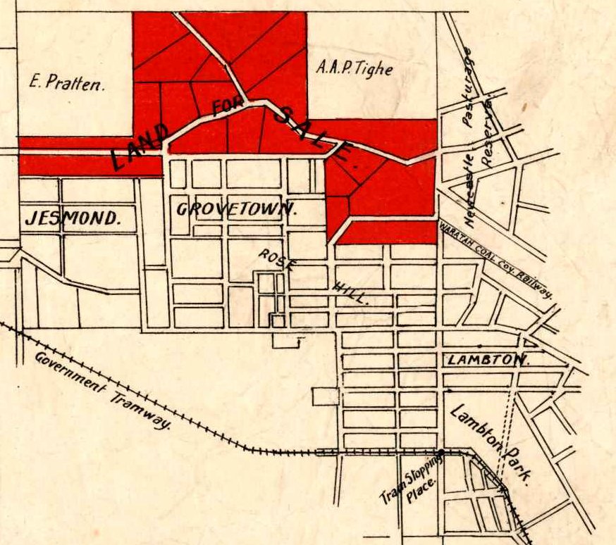
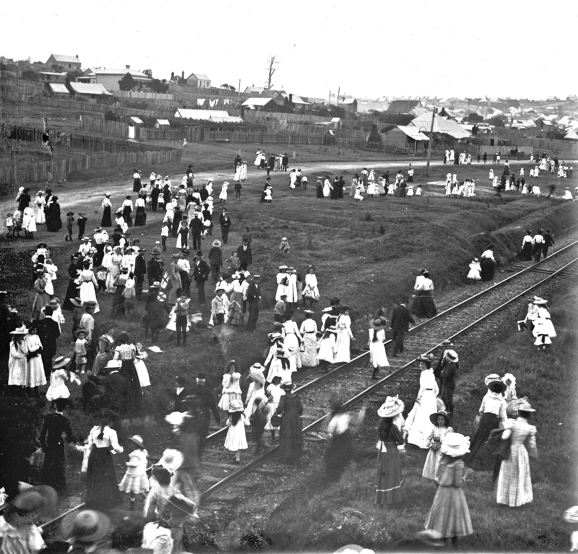
The new coal mine needed coal miners and a village to house them. In 1862 Thomas Grove subdivided his 60 acres of land into small allotments and named it the village of Hanbury, after the place of his birth in Staffordshire, England. One of Grove’s first actions in the development of the village was to donate a block of land on the north-west corner of Station and Cross (now Tighe) Streets, for the erection of a Wesleyan Methodist Church. (See Bk-No 81-870) Thomas Grove laid the foundation stone for the church in a ceremony on 9 September 1862.
An old Parish map showing Thomas Grove’s “Village of Hanbury”, now part of Waratah, and the original “Village of Waratah” which is now part of Mayfield. HLRV
An initial sale of “thirty splendid allotments of land in the fast-progressing village of Hanbury, close to Waratah Station” took place on 15 October 1862. The sale was so successful that Grove immediately arranged for another 29 allotments to be put to public auction on 10 December 1862, at which all but one allotment was sold.
Tracing of the township of Hanbury, 1883. (Note that the tracing is oriented with North to the left, not up.) Open Research Repository.The 1883 tracing of the township of Hanbury overlaid into Google Earth.
At the same time as these land sales were progressing the colliery was ramping up operations.
In a very short time the Waratah colliery (known more popularly at present as Grove’s paddock) will commence cutting their drives in the course of a day or two; and we hear it is their intention to ship the coals thereby obtained.
The Newcastle Chronicle and Hunter River District News, 11 October 1862.
Having established the Waratah colliery and the village of Hanbury, Thomas Grove started making plans to return to his home country and to sell off his remaining land holdings.
W. H. WHYTE, Auctioneer “has (at the request of several applicants for Land, in the village of Hanbury,) prevailed on the proprietor, Thomas Grove, Esq., prior to his leaving for Europe, to permit a choice Block of Land, which he had reserved for himself, to be divided into allotments, for Sale; together with his beautiful Family Residence, known as Banana Cottage, with Orchard and Garden, so delightfully situated, near the Station at Waratah.
The Newcastle Chronicle and Hunter River District News, 31 January 1863.
For reasons unknown, Grove’s return to Europe was delayed for a number of years, with another advertisement in 1867 indicating Grove’s imminent departure from Australia.
W. H. WHYTE has received instructions from THOMAS Grove,. Esq., to submit to public competition, without reserve (prior to his departure for Europe by next Mail) on the Ground, at Hanbury, Waratah, On MONDAY, 8th April, 1867, at Noon : – Twelve Valuable BUILDING ALLOTMENTS
Thomas Grove departed Sydney as a passenger on the steamship Kaikoura on 1 June 1867.
Advertisement for the departure of the Panama Mail steamship Kaikoura on 1 June 1867.
The voyage across the Pacific must have been particularly ‘interesting’, for on arrival at Panama, Thomas Grove and his fellow passengers were moved to place an advertisement publicly thanking the captain for his actions under “trying circumstances.”
Approaching the near termination of a voyage that, in this route, may be regarded as unusually boisterous, we place on record our appreciation of your ability as a commander, displayed under trying circumstances, and your constant vigilance and zeal for the safety of the ship and passengers.
In October 1867, the Waratah Coal Company elected a director in the place of Thomas Grove, “whose seat at the Board has become vacant, in consequence of his departure from the colony.” Thomas Grove died on 9 June 1881 at Wolverhampton in England, where he had named his residence “Waratah Cottage”.
Use of the name “Hanbury” for the village near Waratah Station gradually subsided towards the end of the 19th century. However one place it lingered was at the local school, where Henry Parkes laid the foundation stone of Hanbury Public School in February 1868. T A Braye reflecting on the name in his 1936 lecture stated …
Mr. Thomas Grove was the cause of a great deal of tribulation to the boys of my generation who attended the Waratah School. He called his subdivision “Hanbury,” after his birthplace in England, but the railway station from the early first days of the railway was named “Waratah.” The boys who attended the Waratah School were ordered to write “Hanbury Public School” in their exercise books, but not one of them, to my knowledge, ever did, notwithstanding threats of punishment, and actual punishment. “Waratah School” it was with us, and “Waratah School” it remained.
The school’s name was officially change to Waratah Public School in March 1912.
Hanbury Public School was to the south of the village. On this 1873 map it is marked as “National School, 2 acres”. National Library of Australia.A 1914 subdivision to the north of the township of Hanbury, was unimaginatively named North Hanbury. University of Newcastle, Living Histories.
A number of subdivisions of land by the A. A. Company land north of Platt Street around 1914 were named as being in North Hanbury.
On 1 October 1936, Thomas Alfred Braye presented a paper on the history of Waratah and its early settlers, to the Newcastle & Hunter District Historical Society. The Hunter Living Histories site has a scanned PDF of the transcript of the talk, and while it has had Optical Character Recognition applied, the resulting text is less than desired. I have done a full text correction which I reproduce below, to provide a more accessible and searchable version of this excellent talk. I have also added images and maps at relevant points in the transcript, and links to other web pages.
Braye’s talk was principally confined to the area within or adjacent to “the Municipal boundaries of Waratah”, which covers all or parts of the following suburbs today:
Georgetown
Mayfield
Mayfield East
Mayfield North
Mayfield West
Sandgate
Warabrook
Waratah
Waratah West
The area of land that was the subject of Braye’s 1936 talk, with the boundary of the Waratah Municipality shown in red.
In reading Braye’s words I am impressed with how carefully and eloquently he cites his sources and assigns relevant levels of confidence. For example he notes that he had “no authentic records which can be referred to earlier than 1860″, and therefore had to rely on testimony from older residents. Even in this realm when it comes to details of John Laurio Platt he is careful to note that the information is one further step removed – still worth recording, but inviting caution.
At the time my enquiries were made, he [Platt] had been dead just on 60 years, and as my informants were men between 60 and 70 years of age, they could have only been children at the time of his death, and there was no one who had any personal recollection of him, and all that they could tell me about him was what they had learned from others older than themselves many years before.
Braye’s Talk
I account myself as happy in being permitted the privilege of speaking before your Society on the early history of Waratah, my birthplace. At the same time, I am unhappy in the fact that there are no authentic records which can be referred to earlier than 1860 which may be consulted regarding the Settlement in the area known as Waratah, and which show the reasons for a very rapid settlement of population after 1860.
What I give to-night is information garnered by me from older people as far back as 45 years ago, as I endeavoured to learn everything that I possibly could of the earliest known facts relating to the Settlement at Waratah, Most of the men from whom I obtained my information were at the time approaching 70 years, Two of them, particularly, were natives of Newcastle. How reliable that information was I cannot say, but such as I have obtained it I give it to you.
I am taking, for the purposes of this lecture, as the district of Waratah, the Municipal boundaries of Waratah. I have a plan here from which you will see the area that is known as the Municipal District of Waratah. You will observe that it starts at Port Waratah, runs along what was the old Waratah Company’s railway line to the Waratah Crossing below Georgetown, and thence for a distance of about three miles to the Wallsend Coal Co.’s railway line, and then along that line to the junction with the main Northern line, and from there down on the Southern side of the main Northern line to a point about a chain from the Waratah Railway Goods Shed, and thence by a line running a distance of about 1¼ miles northerly to the Hunter River, and from thence along the southern bank of the river to Port Waratah, embracing an area in all of about 2,800 acres, with an extreme distance from tip to tip of about four miles.
The boundaries of Waratah Municipality. Note that the north-eastern boundary doesn’t align with the present day river front because of later land reclamation.
Within that area of recent years many subdivisions have been made, all bearing distinctive names. Most of them are comparatively modern, as in my childhood’s day we only knew the following: Waratah, North Waratah, Port Waratah, The Folly, Calcina Flat, Georgetown and The Commonage. This will probably surprise the residents of Mayfield, but it is a fact nevertheless – the Subdivision known as Mayfield in its origin about the year 1881 was a very circumscribed area, bounded on the West by Kerr Street, on the North by Crebert Street, and on the East by a line about five chains from Church Street southerly to the Maitland Road, and along the Maitland Road back to Kerr Street, in all an area of 29 acres.
As to how the district got the name “Waratah” is not very clear, but when I come to speak of Simpson’s Grant, the time and circumstances under which the name arose will be detailed. The explanation given to me was that the locality which we knew as “North Waratah” was the most northerly point in Australia where the Waratah flower grew in a state of nature. Although years ago I asked many old people of my acquaintance if they had ever seen the Waratah growing there, I never met one who had, but it is not unlikely from the sandy, loamy nature of the soil to the northern side of Bull Street that somewhere about there the Waratah did grow. Botanically it is stated that the Waratah grew from the Hunter River southward into Victoria and Tasmania, but never north of the Hunter River. Therefore, it is highly probable that North Waratah was truly the most northerly point of its growth. Of the area embraced in the district, grants of land were from time to time made by the Crown to various persons until the year 1863 the Government reserved the remaining Crown lands within the southern portion of the district from selection, and proclaimed it The Newcastle Pasturage Reserve. The reason, I believe, that actuated the then Government in this was the fact that cattle and sheep were being brought from inland for shipment to New Zealand during the Maori Wars, and as they had to wait some time for shipment, the whole of the Crown lands, not only in Waratah but in other adjoining districts, were proclaimed a Reserve, and reserved from selection, but before this proclamation at least three men had selected under the 1861 Crown Lands Act, areas right at the South-western portion of the Municipal District.
I now come to the first settler in the district, namely John Laurio Platt. There seems to be a woeful lack of authentic Information concerning him, and he does not appear to have actively interested himself in Newcastle affairs to any extent that there is any record of, otherwise more must have been known of him. Probably he was too busy endeavouring to make his large grant productive and habitable for himself and his family, and founding a home on it. At the time my enquiries were made, he had been dead just on 60 years, and as my informants were men between 60 and 70 years of age, they could have only been children at the time of his death, and there was no one who had any personal recollection of him, and all that they could tell me about him was what they had learned from others older than themselves many years before. This much was gathered: that he had been an Officer in the Imperial Army, a Lieutenant of Sappers, and stationed with his Company in the Island of Heligoland after that Island had been ceded to the British in 1814. Possibly the reason of him being stationed there was that the Imperial Government was then fortifying the Island of Heligoland, which you will all remember was the Island in the North Sea that the British Government, in 1890, obligingly ceded to the German Government, and the Island which was destined to be made by the Germans a most serious menace to the British Sea Power during the Great War.
Later on, Platt by arrangement with the Home Government, came to the Coal River Settlement (otherwise Newcastle) to take charge of the coal-mining operations then carried on with the aid of convict labour. He arrived at Newcastle at the latter end of 1821 or the beginning of 1822. He was promised a grant of 2,000 acres of land, to be selected by him on the Hunter River. He certainly was not in Newcastle at the time of the visit to the settlement by Mr. Commissioner Bigge, otherwise that pains-taking, exact gentleman must have mentioned the fact, but it is presumed that it was owing to Bigge’s report or letters to the Imperial Government as a result of his visit to Newcastle, that the Imperial Government arranged with Platt to come out and take charge of the working of the coalmines, as in his report he mentions that there were “27 men employed in the working of the mine, and 20 tons of coal can be raised in one day by the number of men there employed,” but he goes on to show that apparently the mining was done in a bad way as he speaks of the bad air and the difficulty experienced in clearing the mine of water.
As showing further that Platt could not have been settled in the district, Bigge mentions that “in 1818 Governor Macquarie gave permission to place a certain number of convicts who had conducted themselves well in some fertile plains that adjoin Hunter’s River, and that are now called Paterson’s Plains snd Wallis’s Plains, to cultivate land on their account, and to hold during the pleasure of the Government, and further, three free persons, consisting of the storekeeper, the assistant surgeon, and the pilot’s son, and who, with the Commandant and the Military, formed the whole free population in the settlement of Hunter’s River, had received grants of land in these Plains.”
Platt arrived in Newcastle some time at the end of 1821 or the beginning of 1822. In the year 1822 he selected the site of his 2,000 acre grant. Whatever his calling my have been, he had little or no knowledge of agricultural land, otherwise he never would have picked upon the land which he did when fertile land fit for tillage higher up the River could have been had by him. Let us try to visualise the land selected as it must have presented itself to his eyes in 1822. This we are enabled to do from the fact that portions thereof had remained untouched for years, and quite adjacent to the portion that he first cleared and cultivated, and where he made his first home on the southern bank of the South Channel of the Hunter River. Immediately behind the Mangroves fringing the River there was a small belt of dense, tropical brush. consisting of wild native figs, black apple trees, myrtle, cedar, and general brush growth. This is extended along a gully running south-westerly back towards the Maitland Road, which, of course, did not then exist. This bit of brush land was the only good cultivatable land there – a matter of about seven or eight acres. The hilly land rising from the River was fairly thick forest land, consisting mainly of Iron bark, some grey gum, and red gum. It is possible that the thick forest land misled the inexperienced Englishman into the belief that the land that could produce such fine timber must necessarily be fertile – little knowing that that class of timber was indicative of the poorest of land. The South-eastern portion of the land was covered with dense ti tree bush, another sure indication of poor country. Other portions were swampy, but generally the area was heavily timbered with timber of a good class. “
We come now to the actual grant. This was dated 30th June, 1823, and was one of the earliest grants made in the Newcastle district, if not the earliest. It was made by Sir Thomas Brisbane, and recites that it was made in pursuance of Royal instructions of the 5th February, 1821. The grant proceeds to give and grant unto John Laurio Platt, his heirs and assigns, all those 2,000 acres of land situate lying and being in the County of Northumberland and Township of Newcastle, bounded on the east by the line bearing south, commencing from Hunter River, 88 chains on the south by a line bearing west 160 chains on the west by a line bearing north to Iron Bark to near its junction with the Hunter River (apparently the surveyors were too tired to give this distance, but approximately it is about 2½ miles), and on the north and north-east by that River.
This grant contained a peculiar reservation, and the only one so far as I know in this district which contains such a reservation, namely a reservation of all timber required for Naval purposes. A further reservation was “such parts of the land as shall be required for a highway or highways.” A stipulation for payment of a quit rent of £2 per annum after the first five years; a condition for the employment of convicts. (So that you may follow the situation of this grant, the commencing point was a little slightly to the north-east to where the Roman Catholic Boys’ Orphanage is situated, and ran in a straight line south to the centre of Platt Street, Waratah, a distance of about 1¼ miles; thence it ran west 2 miles, and thence northerly to the junction of Iron Bark Creek (a matter of about 2¾ miles, and from there between two to three miles along the River back to the commencing point). Commenting on the grant, it seems strange that the land was described as lying and being in the township of Newcastle. In point of fact, it was about four miles from Newcastle, with thick, trackless bush intervening, and dealing with the period, let us hear what Bigge has to say about the Township of Newcastle in 1821. He says that “the township contained altogether 13 houses that belonged to the Government, and 71 that belonged to prisoners.”
As regards the quit rent, it was usual to reserve quit rents in grants of the period. £2 per year, however, seems very little for 2,000 acres, and even that was not to be paid for the first five years. The condition in the grant for the employment of convicts was a common one in those days in grants of large areas. Unfortunately, the records In my possession do not enable me to say the number of convicts stipulated, but it would certainly not be less than five, and possibly would be as high as 20. A great deal of misapprehension exists as to the employment of convicts by early settlers. It is a common error to suppose that they received nothing more than their keep and clothing for their work. As a matter of fact, at the date of this grant, in 1823, the regulations provided that their masters were bound to find them in food which was regulated according to a scale, and pay them in money the sum of £10 per year, reducible to £7 per year if their employers found them in clothes. The pay seems small, but if money values then and now are compared, it will be found that the £10 per year would be equivalent to about £ 30 per year. In other words, they received a little better than the 11/-per week and keep.
The first portion of his grant which Platt had cleared for cultivation purposes consisted of an area of about 40 acres right in the north-eastern corner of his grant, starting from where the Roman Catholic Boys’ Orphanage is now situated, and running a distance south for nearly half a mile, and thence west about a mile. He erected his first homestead and outbuildings just to the south of the Orphanage site. Judging from the nature of the timber-growing there, the clearing must have been a slow and tedious process with the means of clearing then existing, because timber of the nature growing on the hilly portions of the land was very difficult and hard to clear. In point of fact, the clearing had originally gone down as far as where the present Maitland Road goes, but this was not all cultivated, as about a matter of 300 to 400 yards from Maitland Road was not cultivated, and later was allowed to sucker and the forest to start again. Incidentally I might mention this enables me to estimate the extent of growth of the Australian hardwood timber in seventy years because to my knowledge the trees had grown up around the butts of saplings that had been cut down, and they showed in the early 90’s that the growth of iron bark, and spotted gum, and grey gum was no more than about 1’ to 15″ in diameter in that period. That portion which was cultivated (and the furrows still remain there to show the cultivation) was sown with crops of maize and wheat. I might mention that the information generally as to the Platt Settlement was given to me by a Mr. Buxton, who either was born on the Estate, or lived there as a child. The portion that was cultivated and kept clear was known as the Mill Paddock. Mr. Buxton informed me that the reason of this was that a rough kind of a wind-mill was erected by Platt just about where the Orphanage site is now, where the maize and wheat crops were ground for food purposes.
In addition to the cultivation of maize and wheat, Platt also mined tor coal, the coal being loaded into barges by means of barrows, and at high tide poled down to Newcastle. This was done by two tunnels driven just under the Orphanage site, and the seam worked, I believe, was what is known as a floating seam of about no more than 4ft. The two tunnels, in my young days, existed, and evidence still exists of their location. I myself with others, have gone into these tunnels as a boy, but could not penetrate any distance owing to the falls which had occurred.
Apparently, too, there is evidence of oyster shells being removed from Black’s middens for the purpose of making lime, as a great deal of excavation in my young days existed. There is no doubt, from the records as they exist, that Platt intended to make an abiding home for himself and his descendants on his grant. His will, which he made in 1829, left his grant of 2,000 acres (which, by the way, he called “Iron Bark” due, no doubt to the prevalence of iron bark on the property) subject to certain rights, to his wife, and certain payments to be made in respect of his younger children, to his eldest son, stating that it was his wish that his estate at Iron Bark should remain in the hands of the eldest son, subject to a valuation for him to pay such proportions as his Executors should think fit and proper towards buying the other boys each 2,000 acres of land. It will be noted that he mentions his other boys. There were four boys in all, the eldest of whom was Frederick William Platt, and three other boys, but on the 20th December, 1831, two of these boys were burnt to death. The following copy of a Declaration is interesting. It was made by John Butler Hewson on the 14th June, 1861 (and, by the way, this John Butler Hewson was the step-father of Mr. James Hannell, the first Mayor of Newcastle). Hewson, in his Declaration, states that he was for many years Chief Constable at Newcastle; that he knew and was well acquainted with John Laurio Platt and frequently heard him speak of Frederick William Platt as his eldest son; that he remembers two of the youngest sons of John Laurio Platt (named, as he believed, Robert Henry and John Laurie) being burnt to death in the month of December, 1831, and that he found the bodies near Iron Bark aforesaid, and that on that occasion the said John Laurio Platt particularly referred to the said Frederick William Platt as his eldest son.
Now as regards this, when I was a child I, with other boys, wandered frequently over the site of the Settlement, and on a grassy knoll in a gully leading up from the River there were four or five unmistakable mounds which we were told were graves. We had been told that they were the graves of convicts who had died on the property, but it is likely, as was common in those days, that these two boys mentioned were buried there. There never has been any question to my mind as to what these mounds were. In the last year of last century,1899, I had a picture painted for me of the Mill Paddock, and I have that here with me now, and the location of these mounds is marked. As to how these boys were burnt to death there remains no record that I have ever been able to trace, but it is quite possible, that the original homestead was burnt down, because my informant on this point told me that he never remembers the original homestead, and that the only homestead he remembered was one that was situated just at the point where in later years, the road to the Ash Island punt joined the Maitland Road. Of course it was only in very later years that the punt to Ash Island was established. This old house was standing in the late 70’s, and I remember seeing it myself when a child. It was a rather roomy old place, built of sawn hardwood slabs, and roofed partly with shingles and stringy bark. Just to the left of it there had been further clearing and cultivation of an area I should say of about seven to eight acres.
John Laurio Platt died on the 17th July, 1836, leaving as his Executors Major E. C. Close, whom you will remember as being of Morpeth, and his wife, Rosanna. Platt, and a Mr. F. T. V. Bloomfield. Apparently from the records, Mrs. Platt had died in his lifetime, and Bloomfield declined to act, the Will being proved by Major Close. Whatever the desires and wishes of this early settler and pioneer were with regard to his eldest son retaining the ownership of the 2,000 acres, granted to the father, the son on the 22nd October 1839, parted with the land to the Australian Agricultural Company for £6,000. Doubtless Frederick William Platt knew of much better land for agricultural purposes than that which his father had selected, but as to what became of him there is no record that I know of. The only other son of John Laurio Platt was William Hampden Platt, who married one of the Brooks, of Wallsend, and it is after him that the township of Plattsburg was named, being a subdivision made by himself and wife, of his wife’s portion of the Brooks’ Estate.
After the A.A. Co. got possession of the property there was no attempt made by that company to settle the land or do anything with it, and it remained in the same state as the Platts left it until 1885, when the A.A. Co. determined to cut up a portion of the ground for sale, running from the Waratah Goods Shed, along Platt Street, and up to just a little beyond where the Mater Hospital is situated. This subdivision the company called Platt’s Hill Estate, and sold in areas of acre blocks. Later on a good deal of it was re-subdivided, and is now known as Cambridge Park. Before this, in 1856 and the early part of 1857, the Northern railway had been made through the property, but owing to the means of construction then existent there was a long hold-up at what was known for years as the Big Hill – in other words, what we now know as Platt’s Hill. This occupied a considerable time in cutting, but no permanent settlement arose owing to that, as the men employed in the construction of the railway moved on with it, and as I will mention later on, a few did remain as timber getters in and about the district – so that a little more than 20 years after Platt’s death, the main Northern railway ran through his property for a distance of nearly three miles. This railway was ultimately destined to connect up the whole of the railway system from Perth to Brisbane. Where this early pioneer and settler first caused a forest to be felled and the lands to be ploughed there are more than 1,000 people living on it, and this embraces what is known as Mayfield West, Cambridge Park and Platt’s Hill. In addition, three large industrial undertakings are situated on the land, where hundreds of men are now employed – Vickers’ Commonwealth Steel Products Co., the Abattoirs, Newbold Silica Brickworks. and two big institutions, namely the Mater Miseriacordiae Hospital, and the Deaf and Dumb institution – that is speaking of the living, but speaking of the dead, the Newcastle General Cemetery at Sandgate lies wholly within the area of the grant.
The next in chronological order of taking possession, but not in actual grant, is that of the 2.000 acres of the A.A. Co., but I shall not dilate upon this, more than to say that the only portion that came in the Waratah district of that grant was a matter of between 30 to 40 acres – a triangular piece right at the northward corner of the A.A. Co.’s grant.
The A.A. Co. was formed in 1824, and received a Charter entitling the company to select 1,000,000 acres of land for the purposes of agricultural, sheep and cattle farming, and in addition 2,000 acres adjoining the township of Newcastle, and the monopoly of coalmining.
Apparently the company had some dispute with Governor Darling, who seems to have been rather a nasty type of person, and either could not read his instructions from Home, or read them in his own way, with the result that it was not until the year 1830 that the company was enabled to take possession of its grant, so that the company’s grant only comes incidentally into consideration, and in point of fact the company, so far as that portion of the land lying within the Waratah boundaries, never thought it worthwhile considering from the stand-point of any settlement until a little over 20 years ago. Up till about that time most of my listeners will remember the corner I am speaking of, which ran along the Maitland Road, just across the Waratah side of the present coal line, and upon which a slaughter house and boiling down premises were situated, a rather unsightly sight, but with the founding of the Steel Works, and the system of Municipal rating on unimproved land, the A.A. Co. thought it advantageous to subdivide and get rid of the land, which they did.
I now come to the grantee whom I consider as being the main factor in bringing about any substantial settlement within the area, namely Thomas Grove. His grant consisted of 60 acres, the bounds of which were as follows:-
Bounded on the south by High Street, on the west by Bridge Street, on the north by the centre of Platt Street (here it should I be mentioned that this grant adjoined part of the southern boundary of Platt’s grant), and on the east by Turton Road.
Now, at the time of the grant none of these roads existed. What was High Street on the south was known as the township reserve at Newcastle; the same with regard to the east and west boundaries, and the northern boundary was, as I before said, the south boundary of Platt’s grant.
Now the records show that this 60 acres was taken possession of by one George Dent on the 27th January, 1832. As to who George Dent was I could never ascertain, but undoubtedly he must rank (as he was in possession of this land in 1832) as a very early settler. Records further show that George Dent parted with the land to a Simon Kemp somewhere between 1832 and 1843. Simon Kemp was a Newcastle business man, and owner of small ketches trading between Sydney and Newcastle, and a man who acquired a fair amount of property in Newcastle, one of the properties being the site of the present George Hotel, and Parnell’s Chambers, and other properties in Hunter Street. He certainly was never a resident of the locality, and possibly never intended to be, but he equally certainly was a great acquirer of lands. His son became Colonial Architect, and his grandson Mr. Walter Parnell, a member of the Bar of New South Wales. In October, 1843, this 60 acre block was sold by Kemp to Thomas Grove for the sum of £220, From the price paid, it would appear that the land had been partly cleared, probably by Dent, and that there was some kind of a house in existence on it. With regard to Thomas Grove, the information gathered concerning him was that he had come out to this country as quite a young man, and for some years worked on the Williams River, employed by the McPhersons, who were shipbuilders at Eagleton, on the Williams River, just above Raymond Terrace. These McPhersons built several ketches and small craft at their ship-building yards, the remains of which existed 40 years ago, but have apparently disappeared since then.
With the moneys saved by Grove, he came to Waratah in 1843 and occupied the land – partly farming and timber-getting with bullocks which he ran not only on his own 60 acres, but on the adjoining Government lands. The property was known for years by the people of Newcastle as “Bloodwood Paddock,” which indicates the class of timber growing on the land. The top portion had the appearance of fertility, as in the late 70’s there existed what had apparently been a very fine orange orchard, which extended for an area of about five acres on the south-western portion of the property.
No settlement seems to have taken place in this area until about 1857, when a number of the men who were engaged in timber-getting for the Northern Railway, and later on for the for the Wallsend Co.’s Railway, settled on the land somewhere in the region of Smart and Bridge Streets and depastured their bullocks and erected what were just humpies for themselves and their families. There would not be any more than about five or six of them, some of the descendants of whom are still living in Waratah. The families as I know them were Drinkwaters, Brayes, Paynes, Ellis’ and Jacksons – my own people arriving there in August 1857. These first settlers continued to reside there after the railway line had passed on, and in 1859 the Newcastle-Wallsend Coal Mining Co. commenced to construct their railway line out to the Wallsend Coal Mine to connect with the Great Northern line. This gave further employment to the handful of people who were settled there.
In 1860 Mr. Thomas Grove, believing there was coal in the Waratah hills, caused a tunnel to be driven into the side of the hill at a spot just a little below Braye Park, on the Waratah side. About that time a good deal of prospecting for coal was going on and the tunnel resulted, after driving only a few feet, in the discovery of a very fine seam of coal seven-to eight feet thick, being the Borehole Seam, which ended in the Waratah Hills. This tunnel was continued for some little distance, but owing to the dip in the seam, and the trouble in getting the water away, it was determined to drive a tunnel on the southern or Lambton side of the same hill, and in point of fact ultimately two tunnels were driven in there and worked for several years. In 1863 Mr. Grove was instrumental in the foundation and incorporation by Act of Parliament of the Waratah Coal Co. with a capital of 60,000 into 10,000 shares of £ 6 each, the first Directors being Thomas Sutcliffe Mort, of Mort’s Dock fame, Thomas Ware Smart, Charles Smith, Benjamin Darley, Thomas Grove, Atkinson Alfred Patrick Tighe and William Steel. The mine was then completely developed, a railway line was built from Waratah to Port Waratah, where the coal was shipped, and later on this line was extended further west and another tunnel opened, and the line became part of the boundary of the Municipal District of Waratah.
Mr. Grove had one child only, a daughter, who married in 1859 Mr. A. A. P. Tighe – by the way, an uncle of our respected townsman, Mr. William Sparke, a resident of Waratah himself just upon 50 years, on part of Grove’s grant. Mr. Tighe was one of the first directors of the Waratah Coal Co. He represented the County of Northumberland in Parliament for many years, and held Ministerial office.
In 1863 [actually 1862] Thomas’ Grove subdivided his 60 acre block into haIf-acre allotments, and in the first subdivision every lot was sold, being bought by people who were engaged in mining. Business premises were erected, and the first definite settlement to any extent in Waratah settled within the area of the 60 acre grant, the people building their homes and living there.
Incidentally Mr. Thomas Grove was the cause of a great deal of tribulation to the boys of my generation who attended the Waratah School. He called his subdivision “Hanbury,” after his birthplace in England, but the railway station from the early first days of the railway was named “Waratah.” The boys who attended the Waratah School were ordered to write “Hanbury Public School” in their exercise books, but not one of them, to my knowledge, ever did, notwithstanding threats of punishment, and actual punishment. “Waratah School” it was with us, and “Waratah School” it remained.
Thomas Grove’s “Village of Hanbury” and the public school on Georgetown Rd marked on an historical parish map. HLRV
In connection with the Waratah Coal Co. grants were made to the Company of 102 acres of land at Port Waratah, fronting the River, and this land was used in the first place by the Company for shipping their coal, but early in 1867 the Waratah Coal Co., by arrangements with the directors of the Wallaroo and Moonta Copper Mining Co., had most of the area cleared of the timber, and that company established large smelting works and used the coal from the Waratah Coal Co. for smelting purposes.
At this point I would like to mention a very interesting fact concerning Port Waratah, and for which I am indebted to my good friend Mr. Albert Hough. I will read an extract taken from a book in his possession :-
The ‘Lady Nelson’ was the first vessel to visit Port Waratah. About 4. p.m. on Sunday, 28th June, 1801, she left her anchorage in Freshwater Bay, as Newcastle harbour was designated by Governor King in the general orders, and proceeded up the south channel of the river, and at 6 p.m. was moored in three fathoms in Port Waratah. At 7 a.m. next she was dropped into 9ft., as the second mate, who had been ahead sounding, reported he had only 6ft. or 7ft. To satisfy themselves on this head, Grant and Paterson in the launch, at the top of high tide, found no more than 2ft. to 4ft., and at their return sounded the other entrance to the channel, called Mangrove Creek, but now called Throsby Creek; but found no more water, and in many places less. Judging the vessel might touch at low water where she lay, off an island, which Paterson called Needle Island, from its length and narrowness, but now called Spit Island, she was brought back to Port Waratah, where she lay in 16ft. of water sheltered from every wind that could blow. All idea of proceeding up this channel was abandoned, and moving with the kedge they determined to explore the river in boats. This stoppage would not have occurred had they any knowledge of the main or north channel. Hereafter it will be seen that despite the shoally state of Port Waratah there was for many years a most persistent agitation to make it the chief shipping port.
From 1867 to about 1892 that company continuously smelted copper, which was brought from South Australia by barques of 700-800 tons register to Port Waratah. In addition, about the same time the English and Scottish Australian Copper. Co, (another South Australian company) established copper smelting works right adjacent to the Waratah Coal Co.’s line, on the site of which Goninan’s engineering works are now erected at Broadmeadow. These copper works brought about settlement around about Georgetown on what is known as Moate’s Grant, which was granted to one Joseph Moate in 1853, but as he was never a resident of Waratah, and only bought the land from the Government for speculative purposes, I just mention the fact that Georgetown was the part of the subdivision made by his two sons, and on this land most of the smelters or the English, Scottish and Australian copper works built their homes and resided. The Copper Smelting Works at Port Waratah also brought about settlement on what we knew as Calcina Flat. The smelters were in the main all Welsh people at both works, having all come from copper smelting works at Cardiff and Swansea, in Wales. In 1870 the Municipal district of Waratah was proclaimed, and by then a Public School had been built, which still stands, although considerably enlarged. Two smelting works had been established, two quarries were opened for the purpose or quarrying stone, one known as Stevens’ Quarry and one as Whiteman’s Quarry, in the Waratah Hills so that by 1870 Mr. Thomas Groves had the satisfaction and the profitable pleasure of seeing as a result of his energy and enterprise, a thriving township of several hundred people with a well-established coal mine and works which gave constant employment to the inhabitants.
The original old Grove home was standing when I was a child at the top of the Orange Grove which I referred to, at the corner of High and Bridge Streets, Waratah. It was a low, old place, consisting of slab and weatherboard and shingle roof. Mr. Grove, however, built himself a large and more elaborate residence which is still standing just below St. Phillips’ Church of England, Waratah, adjacent to Bridge Street, but somewhere in the early 70’s Grove left Waratah and returned to his native heath in England, where he died. One of his descendants living is Mr. Harry Tighe, an English novelist of some repute, who was a grandson, and another grandson was Mr. William Tighe, a prominent member of the New South Wales Bar, now deceased.
Incidentally it might be mentioned that Mr. Grove had the very doubtful honor of introducing the Lantana into Waratah, as for years a very thick hedge of it surrounded the Orange Grove along Bridge’ Street.
The next settler of note, as bringing about settlement in the area, was one Charles Simpson. Charles Simpson was Collector of Customs at Newcastle in the early 40’s, and to him the honor must be ascribed of giving the name of Waratah to the district. In 1848 he took possession of 35½ acres of land which he had bought from the Government, on the banks of the river adjoining to the eastward what is known as Kerr Street, but it was then called an Occupation Road of half a chain wide. The land near the river was covered with dense tropical brush, and some portion of the old trees still remain. Mr. Simpson cleared a portion of this brush, and from what I know of the country around there, it must have been a most mosquito-infested place at the time, and there he built what was considered in the early days of Newcastle quite a mansion, and he was rowed up and down to his duties in Newcastle by Government men. On the rise at the back of this house it is said was the place where the Waratah grew, and to signalise this, he called his home “Waratah House.” The people of Newcastle, just as promptly, designated at “Simpson’s Folly,” and from these circumstances the name “Waratah House” still survives, and “The Folly” was the name by which all that part of North Waratah was known, the word “Simpson” having been dropped.
In addition to this grant of 35 acres, Mr. Simpson also obtained other grants of 34½ acres and 20 acres all in the same neighbourhood. He lived on his property from 1848 to 1854. In 1854 he, in conjunction with Mr. Charles Bolton, known as Major Bolton, another grantee, cut up their grants on the southern side of what is now known as Bull Street, and sold it in 5 acre blocks. The settlers who acquired the land cultivated it as vineyards and orchards. Among the notable families that settled there was Mr. Peter Crebert (after whom Crebert Street is named), who was one of the purchasers in 1854, and planted vineyards on his block, and made wine there for many years afterwards. Another was Phillip Kuhn, and other purchasers were Crowther, Walters or Waters, Robertson, Russell, Bull, Gray and Baker, and these settlers can be taken as the first of the early settlers in the area in 1854. Most of them were living on their properties in my childhood days at the end of the 70’s.
The railway line was opened from Newcastle to Maitland in 1859, and the station at Waratah, owing to most of the inhabitants then living on the North Waratah side, was named Waratah from that fact, as, owing to Simpson, the neighbourhood had been called “Waratah,” and so the name has remained to this day.
In 1854 Simpson sold his land to Messrs. Morse & Tourle, of New England, squatters. Mr. Tourle lived there for many years, and also planted vineyards and carried on wine-making, which was still going on in the late 70’s.
Another very early settler was Mr. William Thomas Brain. He, at the time when he was an old man, told me his history. He was a native of the farming portion of Warwickshire, and emigrated as a young man of 18 to New South Wales, in the year 1840.
He was engaged in Sydney by Major Scott, of Scott’s Point, Ash Island, to work for him as a farm labourer on Ash Island, at 2/6 per week, and keep and clothing. He worked on Ash Island until the year 1852, when he bought an area of 67 acres, being two grants to a man named John Nott, to whom the land was granted in 1851. Nott never resided on his grants. These lands were immediately to the east of the Platt’s grant, and were cleared by Brain who brought his produce to Newcastle by boat, where it was sold. In addition, Brain bought an area of 32 acres of ground running from Bull Street down to Maitland Road, and the east boundary of which was Kerr Street. This he used as a paddock.
Early in 1864 he sold his farm properties to people who continued to farm them afterwards, and his own grant he sold in 1862, consisting of 32 acres, to Messrs. Roe & Barton. This land was subsequently subdivided by Mr. James Roe, and is now known as the “Newbottle Subdivision” of Waratah or Mayfield. This name, “Newbottle,” puzzled me for many years, and it was only in recent years that the explanation of its origin was known to me. Mr. James Roe had three subdivisions on the Mayfield side of Waratah, namely Monkwearmouth, Houghton-Le Spring, and “New-Bottle.”
Houghton-le-Spring and Monkwearmouth are old County Durham names of which County in England Mr. Roe was a native – in other words, a Geordy. New-bottle should really be “New Battle.” New-Battle Abbey, you will remember was where one of the decisive engagements was fought in the Cromwellian Civil War, but in recent years it is a very extensive mining district, and it was to that district in Durham that Mr. Roe belonged, but apparently the Subdivision at Mayfield was spelt as it was pronounced by the Geordies, namely “New-Bottle,” instead of “New-Battle.”
Of all the numerous grantees of land within the area, and there were very many that I have not had time to mention, there were only four of the original grantees who resided on the lands granted to them as settlers. These were John Laurio Platt, Thomas Grove, Charles Simpson and William Thomas Brain. All the other grantees apparently only bought for the purpose of holding the land, and made no use of it, and these, together with the families that settled at the Folly or North Waratah, whose names I have mentioned, and those on the Waratah side up to 1857, constituted the only permanent residents in the area.
I shall just mention shortly one other grant, but as it comes into what we call “modern history,” I do not intend to elaborate on it. This was a grant made on the 1st February, 1854, to James Price, of Buttai, of 29 acres one rood and 16 perches, bought by him in June 1853. Mr. James Price, of Buttai, never resided on this grant. He had a boiling-down establishment at Buttai, where he killed cattle and boiled down the tallow and collected the hides of the same. After passing through the hands of two other persons, neither of whom lived on the property, this land ultimately was conveyed on the 2nd April 1881, to John Scholey, butcher of Newcastle. For years before the date of that conveyance, the paddock had been rented by Scholey as a slaughter-house paddock, upon which a slaughter-house was erected, and a residence for the slaughterman. The paddock was fenced and fairly heavily timbered. It started at the corner of Kerr Street and ran from there to Crebert Street, along Crebert Street eastward to within about five chains of Church Street, and then southward to the Maitland Road, and back to Kerr Street. Along the Maitland Road there was thick ti-tree bush, particularly at the corner where Amos’ Hotel now stands. I myself, as a boy, have stood on the second rail of the fence and gathered what we used to call “Roman Candles,” off the vine growing on the tops of the ti-trees. The rest of the land was open forest land.
In 1881 Mr. Scholey had this land cleared, stumped and subdivided, and called the Subdivision Mayfield, I believe after one of his daughters. This land was readily sold at good prices, and quickly built upon, mainly fine residences, especially those fronting Bull Street, and then residents being chiefly successful business people of Newcastle. The settlement at the north side of Waratah had remained stationary, but the Mayfield Subdivision was quickly settled, and this brought into settlement also the New-Bottle Sub-division adjoining.
Now, lastly, as to another interesting grantee within the area, Mr. Henry Dangar. This gentleman was the founder of the Dangar family in New South Wales. A native of St. Neots, Cornwall, he arrived in New South Wales about the middle of 1821. He was employed as an assistant to Mr. Oxley, the Surveyor General of New South Wales, and continued in the employ of the Government until about 1829, when, owing to a dispute with that nasty person, Governor Darling, in connection with land matters in Scone, he retired from the Government Service, and was employed as a Surveyor for the A.A. Co. It should be mentioned, however, that whilst in Government employment in 1826, he was one or the Government Surveyors who surveyed out the enormous grant of 1,000,000 acres to the A.A. Co. In all there were granted to him within the area of Waratah 241 acres, and these grants stretched from Platt’s Channel right down to the Maitland Road, and were continued on to the three-cornered piece of land of the A.A. Co., which I have referred to, and continued then right to Georgetown Road, which went through one of his grants.
Mr. Dangar was never a resident, and apparently, with Cornish acquisitiveness, obtained the land purely for holding purposes. It is possible that he had some idea of turning them into farming lands, as in every instance he was shrewd enough to take his land up where fresh water creeks ran through them.
There are quite a number of other grants that I could refer to, but time does not permit, nor would the history of them be of any great interest.
Irishtown (sometimes spelled Irish Town) was the name of locality near Lambton and Waratah, in use in the period 1876-1881. [A 1944 newspaper article states that Dalwood (near Greta) was also originally known as Irishtown.]
The few scant references to Irishtown in newspaper reports seem to equally describe it as being “near Waratah” (15 April 1876, 22 August 1876) and “near Lambton” (3 October 1877, 25 April 1881). This suggests that it was located somewhere between these two townships. A December 1877 article about a lost child stated that she was eventually found …
… in one of the pitfalls situated in the bush between North Lambton and a place called Irish Town, distant about half a mile from Lambton.
The Maitland Mercury and Hunter River General Advertiser, 18 December 1877.
Looking at a 1913 map that has houses marked as black squares, there is an area about half a mile from Lambton in the direction of Waratah that could possibly be the region of Irishtown.
Sometimes it seems that half the buildings in this city are being demolished to make way for something new. So it’s nice to occasionally note a significant anniversary in the life of an historic building.
After the Waratah Coal Company opened a mine in 1863, the population grew rapidly as miners and their families settled nearby. The residents petitioned the government, and the Municipality of Waratah was formed in 1871 to advance the town’s interests.
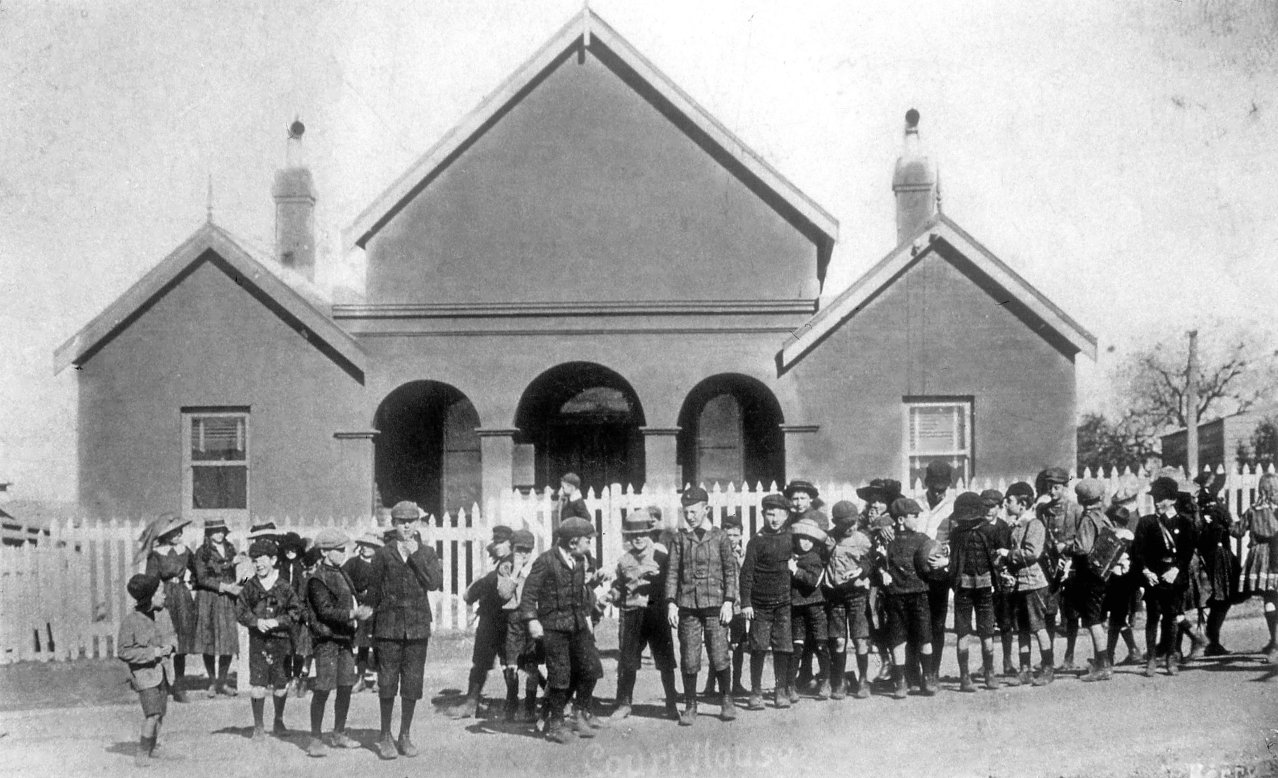
The new council first met in several rented premises, but soon decided to acquire a building of their own. In September 1872 they awarded contracts amounting to £376 for the construction of council chambers on a one-acre site beside the public school on Georgetown Road. They held their first meeting in the new chambers on 16 June 1873, but it was an inauspicious start. The Newcastle Chronicle reported ….
“The interior presented a most cold and dismal aspect, being insufficiently lighted and furnished, with one table and a few chairs. From the entire absence of anything approaching a celebration of the event, and the depressing appearance of the inside, the impression conveyed was that the councillors were thoroughly ashamed of the building, themselves, and the occasion.”
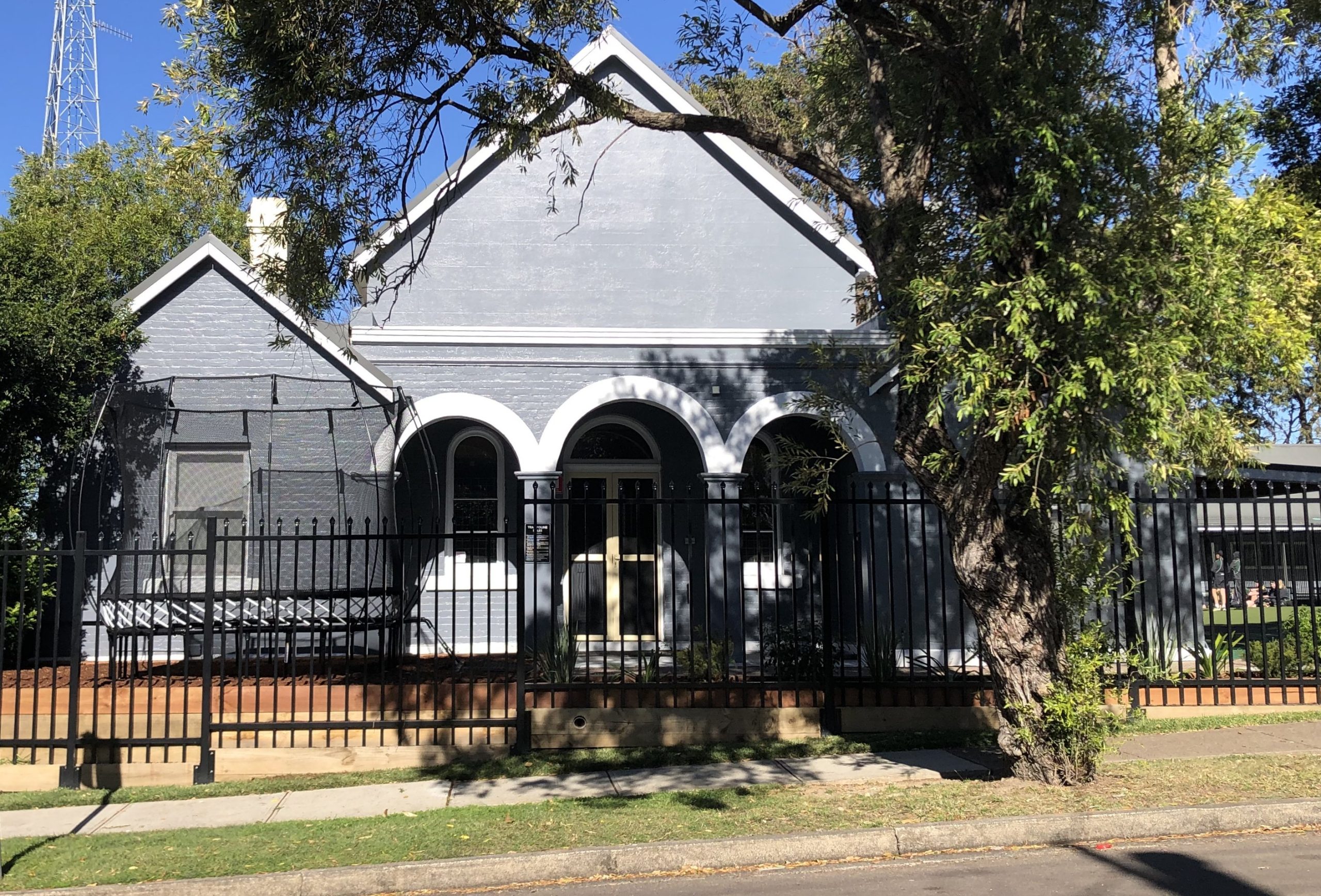
Undeterred by this gloomy assessment, the Councillors were intent on making Waratah a pre-eminent administrative centre. They invited the Government to use the chambers to hold a fortnightly Court of Petty Sessions. When neighbouring Lambton lobbied for a Courthouse in their town, Waratah responded by offering to sell their chambers to the government for Court use. The building sale was completed in 1879, but it was not until 1882 that council vacated, and Waratah finally had a dedicated Courthouse. The Court operated in the building until August 1922. It was then used as a classroom to accommodate growth of the adjacent public school. Despite its “dismal” start 150 years ago, the building is still in use today, part of the Dynamic Learning campus of Saint Philip’s Christian College.
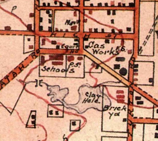
School students in front of the Waratah Courthouse building. Undated. University of Newcastle, Living Histories.The former council chambers and courthouse on 16 June 2023, 150 years since it was first used.
The article above was first published in the July 2023 edition of The Local.
Additional Information
The Miners’ Advocate of 9 May 1873 described the Waratah council chambers building as it neared completion.
In a few days this handsome little building will be completed, and ready for public use. It stands on the breast of the hill, whereon the public school is situated, close to, and parallel with, that edifice. The architectural design is Gothic, in harmony with the school. The Council Hall is a fine apartment 30 feet deep, by 18 feet in width, and 16 feet from floor to ceiling. It is admirably lighted by three fine oblong windows on each side, and two in front and rear. The face of the building comprises a lofty arcade 19 feet long by 7 feet wide, supported by two pillars forming three arched entrances. The arcade is flanked at each end by a convenient room 14 feet by 10, for committee or retiring rooms. A stone tablet built into the front records the year of the erection and the name of the Mayor of the Municipality. We are not aware that any public demonstration will attend the opening of the chambers.
The Waratah Councillors first used their new chambers on Monday 16 June 1873. The Newcastle Chronicle’s report was unflattering, but with a hint that things may get better …
The Municipal Council of Waratah held their first meeting in the new council chambers, on Monday night last. The interior presented a most cold and dismal aspect, being insufficiently lighted and furnished, with one table, a few chairs, and a couple of deal forms. From the entire absence of anything approaching a celebration of the event, and the depressing appearance of the inside, the impression conveyed to the observer was that the worthy municipal councillors were thoroughly ashamed of the building, themselves, and the occasion. No doubt the chamber will, in due time, be properly lighted with chandeliers, and the walls relieved by a few maps, &c. The arrangements would be improved by appropriating the upper part of the hall to the aldermen, and the portion next the door to the public.
Maps
The block of land occupied by the Waratah Council chambers and court house appear in a number of maps, which show the evolution of the site’s use.
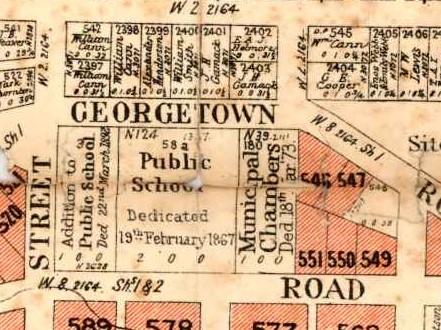
A 1906 real estate poster map shows the 1 acre site marked as “Municipal Chambers, dedicated 18th March 1873”. In 1906 the site was being used for a courthouse. The discrepancy can be accounted for in two possible ways. Being a real estate poster, perhaps they just used an old map without caring too much about how up to date it was? A more likely explanation is that although the building had been sold by Waratah Council in 1879, from a land titles perspective, the land was still gazetted as the Municipal Chambers site.
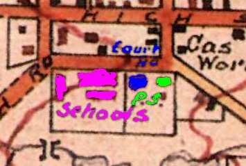
Barrett’s 1910 map of Newcastle is a little bit tricky to decipher, but I believe it has marked “Court Ho” for the court house, and “P.S.” for the police station, as shown in the coloured shading below.
The police station being adjacent to the Court House at this period is attested in this report of needed renovations in1907 …
Attention is again directed to the condition of the Waratah courthouse building. The roof wants renewing with galvanised iron, and the whole building is in need of repair. The fence around the land, and that of the police station adjoining, is also in need of attention.
Newcastle Morning Herald and Miners’ Advocate, 8 August 1907.
"I understand that it is the intention of the directors of the Waratah Coal Company to open their line of railway at the latter part of next week with a view to the company immediately commencing operations in the supply of coal."
"But I think that, if Waratah is to be supplied with water, have its streets formed and lighted, the best way would be by an Act of Incorporation, so as to make those who have most property here pay accordingly."
Waratah Council meeting, report on Council Chambers. "Your committee consider that the
premises at present rented for Council Chambers are, in many respects, very unsuitable for the
requirements of the municipality, but recommend that they be rented at the expiration of the present arrangement for a further period of three months. 2. Your committee further recommend that it is highly desirable that new Municipal Council Chambers be erected on the ground granted by the Government for that purpose, the probable cost of which, after several enquiries made, will not exceed £300. 3. Your
committee also recommend that the Mayor be requested to obtain plans and specifications for
the erection of Council Chambers, such erection to be of brick, with stone foundations. Large
room to be 20 x30; clerks office, 10 x 10; Mayor's office, 10 x 10, with ante-room 10 x 10,
with shingle roof ; in making plans and specification the probable cost as above to be respected."
Waratah Council meeting. Contracts awarded for erection of Council chambers to - G. Gane, stonework completed, £199 ; A. Bung [Burgh], carpenter's work, £129 ; Thos. J. Turton, plumbing, painting, and glazing, £31 10s. ; plastering and colouring walls, £16 10s. Total, £376.
Waratah Council meeting. Motion carried that the inscription to be placed on a tablet to be built into the
wall, over the entrance to the new Council Chambers, should be as follows : — "Waratah Council Chambers, erected A.D., 1873.— Robert Turton, Mayor."
Waratah Council meeting. "Letters from G. Gane and A. Burgh, asking for an extension of time to complete their contract for building the Council Chambers. Five weeks were granted."
"The Mayor's minutes stated that, owing to the blunders of the late surveyor in making the plan and specification for the Council Chambers, no ceiling joists had been provided for ; and as it would take eighteen 21 ft. long, 8 by 2, the contractor had offered to provide and place them for £4 10s. Extra."
Waratah Council meeting. Motion carried "That the contractor be informed that if the Council Chambers be not finished and fit for use on the 1st of May, he will be required to pay the rent of the present room."
"A memorial to the Colonial Secretary is in course of signature, praying for a court of petty sessions, and offering the Council Chambers to the Government for that purpose, without any charge."
"I am directed by the Colonial Secretary to inform you that the offer of the Municipal Council, of Waratah afford the use of their Council Chambers as a temporary court-house; has been accepted, and that the Police Magistrate at Newcastle has been instructed to attend at that place once a fortnight for the purpose of holding Courts of Petty Sessions."
"The Court of Petty Sessions was formally opened here, on last Friday week, but no business has yet been transacted. We have been supplied with magistrates and a chamber where in justice may be administered, but all the addenda necessary to the proper working of the court are wanting, from a clerk for issuing summonses, &c, to the most minor requisite. To what quarter this delay is attributable is one of those mysteries known only to the knights of the red tape."
Waratah Council meeting. "Letter from the Colonial Secretary, announcing that the offer of the use of the Council Chambers for the purpose of holding a court of petty sessions had been accepted, and that the
Police Magistrate would attend from Newcastle every fortnight."
"Mr. Lewis, Government Architect for this district, inspected the Waratah Council Chambers on Wednesday for the purpose of reporting on its suitability for the purpose of a court-house. If his report should be favourable, the Government will very likely purchase the Chambers."
"Some time ago an advertisement appeared in the local papers inviting tenders for the erection of a court-house and lock-up at Lambton. This did not suit the plans of the Waratah aldermen, who are desirous of selling their Council Chambers to the Government as a District Court House."
"There is not likely to be anything more done with reference to inducing the Government to purchase the Council Chambers for the purposes of a court-house. At the last Council meeting Alderman Kerr tried to elicit the opinion of the Council as to what further steps should be taken, but all were dumb, being evidently at their wits' end."
Waratah Council meeting. "Letter from the Minister for Justice, dated May 6, stating that representations had been made that the alterations to the Court House were nearly completed, and that great inconvenience arose from the council occupying it; also, that it would be necessary when the alterations were finished for the building to be handed over to the Police Magistrate for the administration of justice. The MAYOR said he understood from the letter that they must pack up and leave. Alderman Cox moved-- "That the Mayor, Aldermen Whiteman and Turton form a committee to find suitable place for Council Chambers, temporarily."
"The recent improvements to this building have added greatly to its comfort and appearance. The interior and exterior have been painted, the furniture is of the best kind, the magistrates and clerk's rooms have also been renovated; and, altogether, the building will now compare favourably with any in the district."
"Attention is again directed to the condition of the Waratah courthouse building. The roof wants renewing with galvanised iron, and the whole building is in need of repair. The fence around the land, and that of the police station adjoining, is also in need of attention."
"Improvement of a substantial character are being made to the Waratah Courthouse. The shingle roof is being replaced with galvanised iron, and the interior is to be renovated, as well as the magistrate's and clerk's rooms."
"Lambton Courthouse has seen the end of its days of usefulness as far as the Justice department is concerned. Waratah court is to be similarly treated, and from the end of August no more cases will be heard there."
"The new wing which is being added to the public School at Waratah is nearing completion … The new building will provide additional accommodation for 160 pupils, apart from that provided by the use of the old courthouse, as classrooms."
National Emergency Service (NES) - "The new divisional headquarters in the old Court House in the grounds of the Waratah boys' school were used for the first time last night, when senior post wardens met there."
"Reopening of the Georgetown road Courthouse at Waratah will be sought. Mr. J. A. Youngberry said the Courthouse was used 30 years ago when the population was smaller."
In the climate change debate today, there is great concern about the global impact of large coal mines. But 100 years ago, the hot topic in Newcastle was the local impact of little mines. The Newcastle Sun reported in August 1922 …
“A good deal of activity is noticeable among the “baby” coal mines in the hills of Waratah and Lambton. They are generally one-man affairs, the work is hard and the methods crude.”
Some were tiny burrows in a hillside, others a shaft with a wooden tripod overhead to haul up coal in buckets. In the post war economic downturn unemployed men looked to scratch a living by selling coal to nearby householders, the tough nature of their enterprise reflected in the mine names … “Try Again Colliery”, “Lone Hand”, “Perseverance”.
While the “baby” mines were a boon to some, they were a grievance to many. The councils were concerned about undermining of streets and damage to pipes. Residents complained of water run-off and danger to their properties. An inspection by the Department of Mines in November 1922 attended by miners and residents turned ugly and “the parties became bitter in their denunciation of each other and indulged in heated personal remarks.”
Matters weren’t helped by the Department’s manifest disinterest in resolving the dispute. Their view was that the big coal companies who owned the mineral rights were entitled to sublease to the “baby” miners, and the Department could do nothing. Waratah Council then took legal action against one of the mine owners, and the court imposed a substantial fine. By 1924 newspaper reports on the mines had disappeared. Their closure was due to a combination of factors –poor quality coal, increasing suburban development, the threat of fines, but mainly because households were moving to the new technologies of gas, and coal-fired electricity. Ironically these energy sources that were the solution to the local “baby” mines in 1922, are now central to the global climate change problem in 2022.
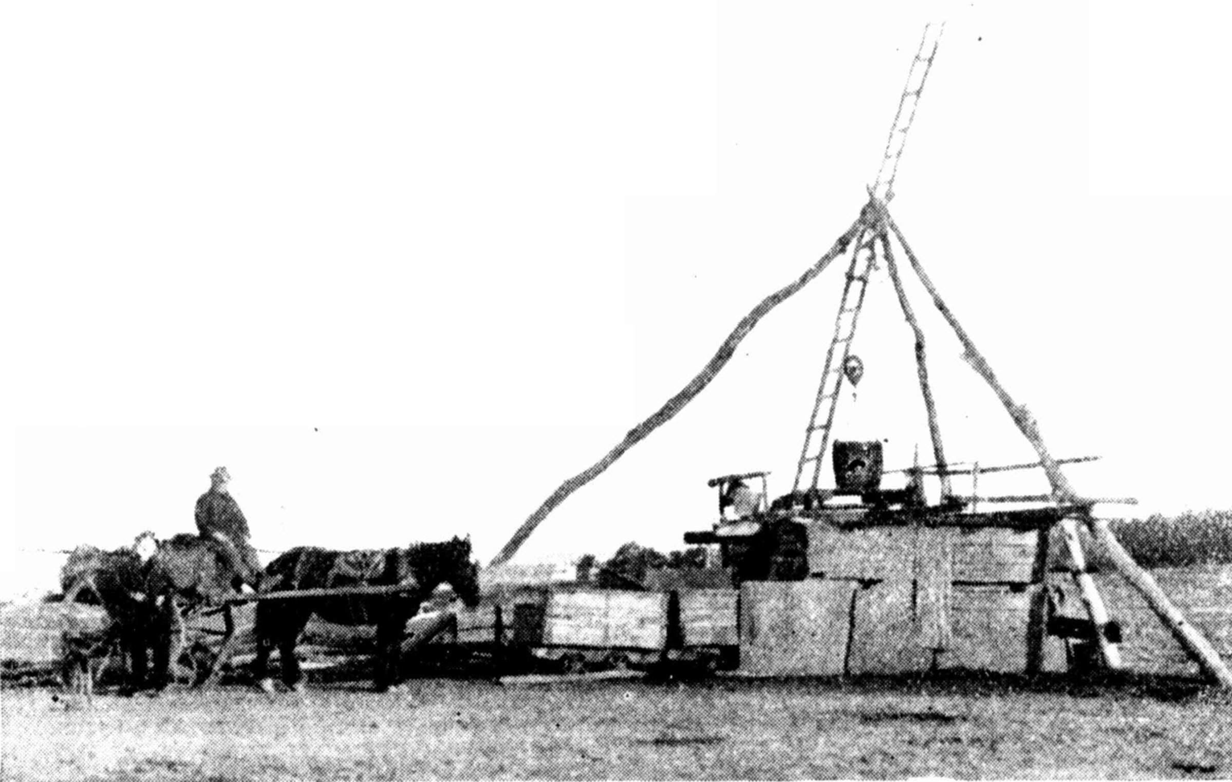
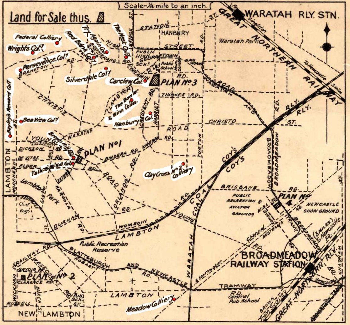
The North Lambton Colliery was one of the bigger “baby” mines. It was located near the underground water reservoir on Newcastle Road and ceased operation in 1924. Photo from Sydney Mail, 8 August 1923.A map from a 1923 real estate poster shows 15 “baby” coal mines in just a two square kilometre area of Lambton and Waratah. University of Newcastle, Special Collections.
The article above was first published in the August 2022 edition of The Local.
Additional Information
The locality sketch on the 1923 real estate poster shows 17 “baby” mines. Many of them are unknown apart from their name on this map.
Bayley’s Reward Colliery
The Bowler Colliery
Brown Hill Colliery
Carclew Colliery
Clay Cross No. 2 Colliery
Federal Colliery
Hanbury Colliery
Meadow Colliery
The Nest Colliery
Perseverance Colliery
Red Bank Colliery
Sea View Colliery
Silverdale Colliery
Talk o’ the Hill Colliery
Try Again Colliery
Winn Colliery
Wright’s Colliery
Other “baby” mines in the Lambton area recorded in other sources such as newspaper reports and Department of Mines annual reports include …
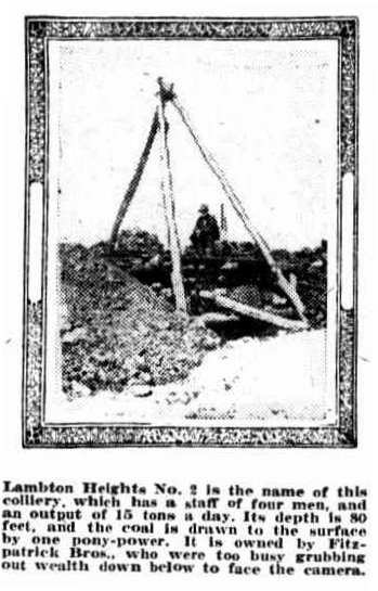
“Lambton Heights No. 2 is the name of this colliery, which has a staff of four men, and an output of 15 tons a day. Its depth is 80 feet, and the coal is drawn to the surface by one pony-power. It is owned by Fitzpatrick Bros., who were too busy grubbing out wealth down below to face the camera.”
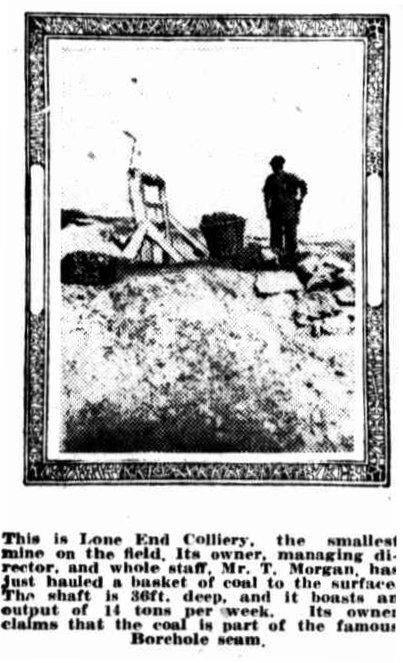
“This is Lone End Colliery, the smallest mine on the field. Its owner, managing director, and whole staff, Mr. T. Morgan, has just hauled a basket of coal to the surface. The shaft is 36ft. deep, and it boasts an output of 14 tons per week. Its owner claims that the coal is part of the famous Borehole seam.”
Although “The Sun” has named this mine as “Lone End Colliery”, I suspect that may be an erroneous reference to the “Lone Hand Colliery”. In the annual report of the Department of Mines for the year 1921, Inspector Bissett states that …
“Two small mines were commenced during the year; these were Lone Hand and Rosehill No.2 Collieries.”
The Lone Hand Colliery is mentioned again in the 1922 annual report, but is not mentioned in subsequent years. Note that Rose Hill (occasionally misspelled Roe’s Hill) was the name of the hill to the north of Lambton township, as shown on this 1908 real estate map.
William Robinson (known as “Tubber”) had a “baby” mine in George Street near Notley Street, North Lambton. He also had mines at Wallsend in the proximity of the High School. William’s brother Jeremiah (Jerry) Robinson had a “baby” mine in Seventh Street, North Lambton.The photo below shows the George Street mine.
Harry (Alf) Cox with his future father-in-law, William (Tubber) Robinson, circa 1930s. Photo courtesy of Ron Robinson.
The photo below of William and his sons with a pit pony, was taken near Robinson’s house in Fifth Street North Lambton.
William (Tubber) Robinson and his sons, Clarence (Joe) Robinson and William Jr (Bill) Robinson, circa 1930s. Photo courtesy of Ron Robinson.
North Lambton Colliery
The North Lambton Colliery, whose photo appeared in the published article, was somewhat different to the other “baby” mines. In contrast to most of the “baby” mines that employed only one or two men and were very short-lived in operation, the North Lambton colliery operated for 20 years (1905 to 1924), and at its peak employed 28 men in 1918. The mine, despite its larger size, used the same primitive techniques as the “baby” mines, sinking a shallow shaft, erecting a wooden tripod, and hauling coal up the shaft in buckets.
North Lambton Colliery.-On 26th September, Mr. J. Jeffries notified, in terms of section 30 of the Coal Mines Regulation Act, that he had opened a new mine on land leased from the Scottish Australian Mining Co., the name of which would be North Lambton.
The location of the colliery being close to the water reservoir on Newcastle Road Lambton, can be ascertained from a report to the Newcastle Water and Sewerage Board in February 1906 …
The proprietor of the North Lambton Colliery gave notice that the workings of his colliery are now approaching within 40 yards of the Lambton reservoir fence, and stated his intention of removing coal to that boundary in terms of a lease held by him from the Scottish Australian Mining Company, Limited.
The engineer of the Water and Sewerage Board reports that it is understood Mr. Long, manager of the North Lambton colliery, intends sinking a shaft near the eastern fence of the Lambton reservoir property. The proposed mining work will probably not affect the reservoir or the pump-house, but might affect the 12-inch scourpipe from the reservoir and some trees.
The Newcastle Sun of 30 September 1922 noted that the colliery was a …
… tribute mine working the outcrop pillar coal left by the Lambton colliery. The coal from North Lambton, employing sixteen persons, is carried to the Lambton screens, and there put into waggons and sent for shipment.
The Sydney Mail of 8 August 1923 in publishing their photo of the mine, noted that …
This small mine is situated at North Lambton. It has an output of 30 tons per day, and gives employment to 10 men. It has been working for 20 years, and is owned by Mr. W. Long, who is shown seated on his cart, loaded with coal. The winding gear is worked by a horse hauling on the cable.
First mention of the term "baby coal mines" in the newspaper.
"The streets of Newcastle are not paved with gold, but underneath them all is something nearly as precious. Coal seams are everywhere, and it is only a matter of digging and coal can be found. Where less fortunate peoples have to pay £5 and £6 a ton for coal, many people in the suburbs of Newcastle just dig in their back yards, and from the baby coal mine there take enough to supply their own needs."
"So that the people who operate "baby" coal mines in the hills of Waratah, and endanger the safety of houses in the vicinity, might have a stop put to their mining, the council asked the Minister for Mines to grant no more permits for the taking of coal from these lands. The official reply received last night was vague and indefinite ..."
"Trying to put a stop to the private mining that goes on at Lambton, and endangers the safety of water and gas mains, apart from damaging the roads, the Mayor last week asked the Minister for Mines not to grant permits for this mining. The latter replied that most of the mineral leases were held by a mining company which seemed to have a perfect right to lease certain areas to private people for the purpose of exploiting the remaining coal seams."
"Several Inspectors from the Department of Mines will visit Waratah next week, and in company with the Mayor and aldermen, will visit the sites of the "baby" coal-mines in the hills, which have been complained of by residents who are fearful of damage to their properties."
"Expert opinion on the question of the damage likely to result to streets and dwellings on Roe's Hill, Waratah, through the opening up of "baby" coal mines, will be given by Chief Inspector Atkinson, of the Department of Mines, who will visit the shafts complained of to-morrow afternoon."
"Many householders came out to emphasise the general grievance when Chief-Inspector Atkinson and Inspector Tennant, representing the Mines Department, made an inspection of the "baby" coal mines on Lambton and Waratah hills yesterday afternoon ... At times the parties became bitter in their denunciation of each other— that is, the property owners and the coal hewers … The Mines Department had to consider the resources of the country, said Inspector Atkinson, and to see they were not wasted ... The inspector intimated that the department could not offer much assistance."
Waratah council given legal opinon on the "baby" coal mines that "showed that the council had power to stop such mining under public roads. The owner adjoining any land being undermined had a natural and legal right to prevent his land being endangered, but there was no cause for action for damage until the land was disturbed."
"Another chapter in the history of baby coal mines was unfolded last night when Waratah Council served a notice upon William Metcalfe to fill in shafts sunk in Sixth and Seventh streets, Rosehill. A prosecution is to
follow if the order is not obeyed."
William Metcalfe prosecuted by Waratah Council "for having made a hole in a public road without authority… Metcalfe was fined £5, with £4 8s 5d costs, in default one month's gaol."
"William Metcalfe, who is working a 'baby' coal mine at Waratah, was proceeded against by the Waratah
Council for allowing a shaft to remain in a street of the municipality… A fine of £8 was imposed, together
with 8s 6d court costs and 42s professional costs."
"North Lambton, more familiarly known as Lambton Heights, merges into the Jesmond district. There are a number of 'baby' coal mines in the district, and the landscape is dotted with wooden tripods, over small shafts, used to lower and raise the miner-proprietors, and the coal they win from their little collieries."
[This is the last mention of the 'baby' coal mines in the newspaper, until a couple of references to 'baby' coal mines at Wallsend in 1931.]
"Owing to the flooding of several small 'baby' coal mines at Wallsend, the already large number of unemployed has been added to. These mines employ between 25 and 30 men."
[Last reference to 'baby' mines in Trove.]
Thanks to Cath Chegwidden and the resources of the Historical Land Records Viewer, I’ve been able to correct a minor error in my Waratah Council page, on the exact location of the final Waratah Town Hall in Hanbury St. Mayfield. It was located where the current Ex Services Club is now, on Lot 8 Sec 2 DP8673.
Third Waratah Council Chambers/Town Hall. Hanbury Street, Mayfield. Newcastle Libraries Online Collection 163 001695Lot 2 Sec 2 of DP8673, the location of Waratah Town Hall, 1926-1938.Vol-Fol 44-8, resumption of land for the Waratah Town Hall. Lot 8 Sec 2 in Hanbury St Mayfield.
This month’s photograph, taken at the border between Lambton and New Lambton looking along Howe Street invites the question “Why is a large group of well-dressed adults and children walking along the tram track towards Lambton?” The answer turns out to be related to transport, but not to trams.
Afterwards the Lambton Colliery railway was occasionally used to convey passengers to special events. One example was the Lambton Public School annual picnic day on Wednesday 25 February 1903. At 9am a train of seven cars left Lambton colliery with 500 children and 400 adults on board and headed for Toronto. On arrival there were refreshments, sports competitions, musical entertainments, and Ralph Snowball was on hand to take group photographs.
At day’s end the picnickers returned by train to Lambton and disembarked near the bridge over the tram line. In the fading light of a summer’s evening as they headed for their homes, Snowball took a final photograph, capturing one of the last occasions a passenger train arrived at Lambton.
The article above was first published in the November 2020 edition of The Local.
Additional Information
Photo date
In the article published in The Local, I stated without qualification that the Snowball photo was taken on 25 February 1903 on the occasion of the Lambton Public School Picnic. It is important to note that the photo has no direct attribution to this date and event, but this conclusion is based on indirect evidence. Behind this story was an interesting case of how to locate and date a photograph.
When the University of Newcastle Special Collections first uploaded Snowball’s photo to their Flickr site, somehow it was mistakenly captioned “View from a train, Singleton”. In 2013 both John Shoebridge and Robert Watson identified that the scene was Lambton, and not Singleton. Robert in particular confirmed the location as being Lambton by comparing a number of houses on the top of the hill with another old photo of Lambton.
Houses near Dent St on mis-captioned photo.
Houses near Dent St, Lambton.
In determining the date of the photo, back in 2014 Robert noted that there was an electric light pole, which meant the photo was taken in or after 1890, when Lambton first installed electric lighting.
The next step in unravelling the mystery came six years later, when Robert revisited the photo and made two key observations.
The people in the photo are almost all women and children, with very few men.
A couple of the children are waving flags.
I did a careful count of the people in the photo and found that adult women outnumbered the adult men, three to one. This would indicate that the event being captured took place on a weekday, when the majority of men would be at work. The large number of children would then suggest that this is a school event. This is supported by looking at one of the flags being held aloft, which appears to be the NSW State flag, suggesting that the event was connected with the Lambton Public School.
Child waving flag.
NSW State flag.
Prompted by Robert’s observations I then made a third key observation – that the crowd in the photo is not random or dispersing. With one lone exception there are no people in the side streets. Everyone is heading in the same direction. This would indicate that the people are moving as a group, having come from a particular point and heading towards a particular destination. This would be consistent with the idea that the group has just disembarked from a train on the colliery railway and are heading home to Lambton.
Given that the crowd is well dressed I made a guess that the event was connected with a picnic, and along with the three key observations already noted, I searched in Trove in the known date range for the keywords “Lambton train school picnic”, which immediately revealed a very likely candidate for the occasion – the Lambton Public School picnic on 25 February 1903.
One final and compelling confirmation of this dating, came from Newcastle Library’s Online Collection. Knowing that the collection had quite a number of Ralph Snowball picnic photos, I searched the collection and found a photo that Ralph had taken at the school picnic at Toronto on that day. It is quite probable that Snowball travelled with the school group in the chartered train, and took a photograph of the disembarked passengers from the train carriage up on the embankment before the rail line traversed the bridges over Hobart Rd and Howe St.
Group photo from Lambton Public School picnic at Toronto, 25 February 1903. Photo by Ralph Snowball. Newcastle Libraries Online Collection 001 002292.
There is one other documented occasion, on 23 November 1900, when Lambton Public School travelled by train to a picnic at Toronto. It may be that Snowball’s photo was from this earlier picnic, but given Snowball’s picnic photo from 1903 I think it much more likely that it is of the February 1903 picnic.
The Waratah Company Rail LINE Passenger Service
Passenger train services to and from Lambton on the Waratah Coal Company’s railway commenced on Monday 25 May 1874, with a special train on the Queen’s birthday public holiday. Regular weekly Saturday evening services then commenced the following Saturday 30 May 1874. By March 1875, falling patronage meant that services were reduced to alternate Saturdays. The last passenger train on the line ran on Saturday 19 August 1887.
Passenger pick-up and set-down was at a location known as “Betty Bunn’s Crossing”, which was the point where the road between Lambton and Waratah crossed the coal company’s railway.
I have never seen an old map with Betty Bunn’s Crossing marked on it, but all the evidence of many newspaper articles points to it being the crossing of the Waratah coal rail line with the Lambton to Waratah road. Another reasonably clear indication of the location is the death notice for Thomas George Griffith who died “at Betty Bunn’s Crossing” in 1918. The 1906 map shows his property adjacent to the crossing.
Death notice for Thomas George Griffith, of Betty Bunn’s Crossing, Lambton. 16 May 1918
Property location of T. G. Griffith, Lambton
Notice in Newcastle Morning Herald and Miners Advocate, 19 Aug 1887, advising of discontinuance of passenger train services to Waratah Tunnels near Lambton.
Railway Timetables printed on 19 Aug 1887 and 20 Aug 1887, showing the dropping of the fortnightly Waratah Tunnels service.
By August 1863 the Lambton colliery railway was almost completed : "… the Waratah and Lambton Collieries, whose branch lines are already formed, only requiring some further slight addition being made to their permanent ways."
"A meeting of miners was held at Pit Town, for the purpose of expressing the disapprobation of themselves and the inhabitants of Lambton and Pit Town generally, at the recent raising of the passenger's fares on the Lambton railway from 6d. to 11d. The meeting resolved that a deputation of four wait upon Mr. Croudace, the colliery manager, and ask him to represent to the Government the following requests, namely: 1. That the fares be lowered to 6d ; 2. That return tickets be issued on the railway ; 3. That a carriage in lieu of the present break van be substituted for passengers."
"Within the past few days a memorial has been taken round the city, to which the names of a large number of the inhabitants have been attached, for presentation to the Minister for Works, with reference to having a regular passenger train to run between this city and the various coal mines, on a Saturday, for the convenience of the people residing in those localities who are desirous of visiting Newcastle."
Call for a passenger train on the Lambton railway … "Why not, in order to give the enterprise a fair chance, have a thorough special train for Saturday afternoons, to leave Old Lambton (which would suit the requirements of the neighbourhood of Dark Creek and New Lambton, too) say, at, from four
to half-past four o'clock."
The letter writer also notes the bad state of the roads … "Lambtonians have to wend their way
betimes up to their knees in mud through a nasty road, extending over a distance of from two to five miles, to reach the Government six o'clock train at Waratah, which is by no means a pleasant undertaking, particularly after a hard day's work, and which few, from mere choice, care about tackling, I can tell you. "
In regard to "a petition from the inhabitants of Lambton, praying that a goods and passenger train may be run to Newcastle" the Commissoner of Railways writes that "by a special arrangement with Messrs. Morehead and Young, a passenger train used to run to Lambton, but in January, '67, they asked to be relieved ; this was consented to, and the traffic then ceased. I cannot, therefore, reintroduce the practice without, the consent of Messrs. Morehead and Young."
It appears that there are occasional passenger services on the Lambton line on pay Saturday's … "This being pay-night, the principal street in the city was more thronged than we have seen it for a considerable time past. The various trains from Wallsend and Lambton brought in a large number of passengers, and these added much to fill our main street."
"Here is the case of the people living at Lambton and New Lambton ; and so far as railway communication is concerned, they are completely isolated, although when the pits are at work they have from four to five trains per day running to each of the collieries; but being private ones, and the
proprietors refusing to allow passenger traffic on them."
A one-off experiment of a passenger service to be tried. "The committee appointed to agitate for a train to run between Newcastle and Lambton have at last succeeded, after great exertions and through strenuous efforts … A special passenger train will run from Newcastle to Old Lambton Crossing on Saturday night, the 28th February, 1874. The train will leave Lambton for Newcastle on or about 5 o'clock p.m., and returning from Newcastle to Lambton on or about 11 p.m. The fares will be 9d. for the return ticket and sixpence for the single fare."
"A Saturday night train commenced to run from Lambton to Newcastle on the 28th ultimo, and over 500 return tickets were taken, besides single ones; the brass band accompanied the excursionists, amounting in number to about 900. "
"Saturday last was a new era in Lambtonian history. The passenger train, as announced, arrived here about 4 p.m. with fourteen carriages and the van, and long before the appointed time for starting almost every available seat was occupied. We have heard that there were more than 500 tickets sold. If this train is to be permanent, as we hope it will, there will have to be some other arrangement for giving out the tickets, for it will never do for people to have to climb up into the guard's van, as was the case on Saturday."
"This train is a fine thing for the business people in Newcastle, but quite the reverse for our town's business folk, who are considerably down in the mouth about so much ready money going out of their
hands … the next step ought to be to agitate for a goods train to be run here."
Newcastle Chronicle's report of a public meeting to discuss getting a passenger train service to Lambton. An allegation is made that business people agitated against aregular train service as it would hurt their trade.
Mr W Goodhew “observed that the Lambton line was a good and convenient one no doubt, but when they were allowed the use of it on one night, and deprived of it the next what dependence could be placed on it. He moved that application be made to the directors of the Waratah Coal Company for permission to run the train on their line of railway to the new tunnel, to Betty Bunn's crossing.”
The Newcastle Morning Herald's report of the public meeting regarding a passenger train service to Lambton. The report notes that "Mr. Croudace, the Manager, has granted permission for a passenger train to be run from here to Newcastle on the demonstration day and also for a Saturday night's train for four Saturdays ; and if it proves payable, the train will run regularly." Despite this promising sign, a regular train service on the Lambton line never eventuated.
"Great disappointment was felt at the non-arrival of the passenger train last Saturday evening. There were about 200 or 300 passengers waiting, who had to return to their homes annoyed. The blame is attributed to Mr. Croudace, for, I believe if he would consent to the train's running, the Government
would; and, the advantage the inhabitants would derive would be very great."
"The subcommittee appointed to conduct the application to the Waratah Coal Company, for a passenger train to be laid on, have received a reply from the directors, expressing their willingness to
grant the request … The sub-committee accordingly waited upon Mr. Higgs, the traffic manager, to
gain the required Government permission, and that gentleman has informed them that there were some arrangements pending respecting a train to be laid on by the Lambton Company, which had not yet been decided upon."
"A meeting of parties interested in the Lambton train movement was held at the Lambton crossing, Mr. T. Hardy in the chair, when it was determined to send a deputation to the Minister for Works, to impress upon him the necessity of running a passenger train to this town at once."
"I have been instructed to inform you that the directors of the Waratah Coal Company have no objection to the Government running, for the convenience of the inhabitants of the district, on Saturday nights and holidays passenger trains on the Waratah Coal Company's private line of railway,
from the junction with Great Northern Railway to the Company's new tunnel, at the same rate as it is
done on the Wallsend Coal Company's line, provided arrangements are made so as not to interfere with the Waratah Company's coal traffic, and that the Government construct at its own cost all sidings,
platforms, landing places, &c., which may be required for passenger traffic."
The following Monday, being a public holiday for Queen Victoria's birthday, "arrangements were made for the train to leave Bunn's crossing on Monday, 25th May at half-past 10 o'clock a.m."
First passenger train on the Waratah Company railway.
"The Railway Auditors laid on a train from Bunn's Crossing, on the Waratah Company's line, on Queen's Birthday, which was moderately patronised."
In the same week that passenger trains start running to Lambton on the Waratah Company line, promises are being made to run passenger trains on the Lambton colliery line … "The following arrangement was made, between Mr. Croudace, on behalf of the Lambton Company, and the Minister,
viz., that [Government] trains should be run ... that the Company give their line free and keep it clear of their own traffic ... The Government to take all other responsibility … this arrangement to come in force immediately after the holidays."
In spite of this arrangement being made, nothing came of it.
"Although the Minister for Works promised that a passenger train should be run to this town on the first Saturday after the holidays, no communication whatever has been received by the Traffic Manager on the subject. The arrangement made between the Minister for Works and Mr. Croudace was that four trains should be run, commencing on the first Saturday after Queen's Birthday."
"On Saturday, the first evening train for passengers ran from the Waratah Co.'s Tunnels to Newcastle, for the accommodation of a large population in that neighbourhood. The number of passengers by whom it was availed of, amply testified the necessity for the convenience. We take it for granted that the train will be continued, as otherwise the people of Grovestown and Lambton would have to give
up all idea of getting into Newcastle during the winter evenings, either by way of the Broad Meadow or Waratah, the former being a sheet of water, and the latter a perfect slough of mud."
"Nothing further has transpired here with reference to the granting of a passenger train [on the Lambton line], and many are now of opinion that it will not be allowed, as the one from the
Waratah Tunnels is so central."
Fatal accident on the Waratah Company railway, when the Saturday evening passenger train strikes Andrew Tunney, who while drunk was riding his horse along the railway.
After the death of Andrew Tunney on the railway line, the passenger service to Lambton is halted. A conspiracy theory arises that storekeepers on the inquest jury had a vested interest in stopping the passenger service in order to keep business in the town.
"I believe that it is also intended to make another effort towards getting a passenger train on the Lambton line, and with some chance of success. Mr. Croudace has been heard to express his willingness to allow it, and no doubt the Government will have seen by this time the fallacy of running the train to the Waratah New Tunnels. As a proof that they have seen their mistake the train is now only run on alternate Saturdays, and then with very few passengers, the majority of the people preferring to walk to Waratah station or down the line to Hamilton rather than go to the new tunnels, which is very little nearer."
A public meeting to petition the Governemnt "asking them to construct a branch line of railway from the Great Northern, through Lambton, and thence to Wallsend."
"It was one of the anomalies of the coal-mining district of Newcastle that a line of railway came into the centre of each township, and yet the residents could not travel on these lines at all, or they did so as a favour, granted by the coal companies, which they could withdraw at any time."
The movement pushing for this railway never gained momentum. Instead, in the next decade the push was for a tram line rather than a train line to Wallsend.
The possibility of running a special passenger train on Lambton line to take patrons to see a performance of “Little Nell” at the Victoria Theatre is discussed. "I am sure that Mr. Croudace would allow a train to run on his railway for this purpose. He has obliged Mr. Bennett in this way before
and would do so again."
A rather tongue-in-cheek one sentence report of a minor incident on the Waratah Tunnels line … "The gates on the Waratah Railway were closed when the Passenger train was coming up from Newcastle on New Year's night, but the engine opened them without a key."
"The alteration in time of the Pay-Saturdays' passenger train to the Waratah Company's Tunnel, from 2 o'clock p.m. to 11 o'clock a m., does not meet with the approbation of the public. The housewives especially are dissatisfied with the alteration, as 11 o'clock is too soon for them to leave home, having their domestic duties to attend to."
"At the last Municipal Council meeting Alderman Thornton very properly drew attention to the want of accommodation, in the shape of a platform, at the Waratah Company's tunnel, for the use of passengers travelling from there to Newcastle on pay Saturdays."
Lambton Public School picnic to Toronto. "About 9 a.m. upwards of 600 children, all nicely dressed in holiday attire, with their flags and banners, presented themselves at the school grounds, and formed a spectacle well worth witnessing. A procession was then formed, and the little ones marched along Elder-street and through the park to the Lambton Colliery railway, where, thanks to the kindness of Mr. T. Croudace in granting the use of the line, a train of seven cars awaited them."
Planning meeting for the Lambton Public School picnic. "It was decided to hold the picnic at Toronto, entraining the children at the Lambton Colliery railway, as in the previous year, if Mr. Croudace and
Mr. Kitching will permit the train to run on the colliery line."
(The reference to a picnic train "in the previous year" is a little puzzling, as I can find no record of that event. It may be that it is a time-inaccurate reference to the picnic in November 1900, two years previously.)
"The annual picnic of the Lambton Public School will be held on Wednesday, the 25th instant. The train will leave Lambton Colliery at 9 a.m., calling at all stations on the way to Toronto. There has been an energetic committee at work for some months, preparing for the event, and it is hoped that the parents will show their appreciation of the good work done by attending in large numbers on that day."
"The annual picnic of the local Public School, took place at Toronto on Wednesday, and was largely attended by the parents and the general public. A train of seven cars left the Lambton Colliery railway at 9 a.m., containing about 500 children and 400 adults … The return journey was made in time to allow
the little ones to get home before dark."
After a rain delay this week, Time Tram Twin is back. Today is from Bridge St Waratah (near Lorna St), which was the terminus of the Waratah tram line. The building on the left was the Deaf and Dumb Institution, and is now the Bethel Aged Care Facility.