The Newcastle Family History Society’s (NFHS) Bulletin No. 15 in October 1984 describes Calico Town as being “Wallsend, Lake Road area”, however there appears to be scant evidence for this. A 1948 refers to Wallsend’s first school being “held in a calico tent at Calico Town (Lake Road) nearly 90 years ago.”
The dating in this article is somewhat contradictory, with “90 years ago” implying the school opened in 1858, but the 84 year old resident stating that he attended the opening in 1870. To add to the confusion, the only other reference I could find to “Calico Town” was a 1955 report by architecture students of Newcastle College, which gives yet another date for the school opening when stating …
In the same year, 1862, the first National school was held in a calico tent at Calico Town on Lake Road.
With only two references to Calico Town on Lake Road, the earliest some 80 to 90 years later, I remain unconvinced of the genuineness of this obsolete name.
Blue Gum Flat (sometimes spelled Bluegum Flat) was an informal name of a flat area situated between Jesmond and Wallsend. Being an informal name rather than an official district, only a general idea of the boundaries can be gleaned. [Ourimbah, on the Central Coast was also originally called Blue Gum Flat, but that is not the subject of this article.]
The name first appears in a newspaper report in 1861 …
A reward of £100 has been offered by the Wallsend Coal Company for information tending to convict such party or parties who recently placed a log of wood on their line of railway near the Blue Gum Flat Bridge.
The Newcastle Chronicle and Hunter River District News, 3 AUGUST 1861.
Further details of Blue Gum Flat appear in an advertisement on 20 August 1862 for the lease of “a substantial house, with 10 acres of land” being “near Wallsend” and “near the three lines of railway now starting”.
The railway referred to would be the Newcastle-Wallsend Coal Company railway that was constructed in 1861 and operations of the mine and railway were just starting in 1862. Parrott’s 1893 map shows two rectangular areas adjacent to the railway with a number of houses marked.
It may be just a curious coincidence, but overlying the 1893 map into Google Earth, measurement shows the area of those two rectangles to be 10 acres, the same area as in the 1862 advertisement.
In a funeral notice from 16 February 1880 for William Edmund Wilkinson, Blue Gum Flat is described as being at Brookstown, Wallsend. Brookstown was the area near the old Wallsend Hospital.
In 1887 the residents of Blue Gum Flat were petitioning for a railway platform …
Blue Gum Flat township is about two miles from Wallsend, and close to Jesmond. There are a large number of residents in that locality who, although they are blessed with a railway on one side and the tramway on the other, are unable to avail themselves of either means of transit unless by walking nearly two miles. The proposed platform will be on the Newcastle side of the Wallsend Tunnel Railway.
From this description, Blue Gum Flat is the area between the Newcastle-Wallsend Coal Company railway (yellow), and the Wallsend tramway (green), with the proposed site of the rail platform “on the Newcastle side of the Wallsend Tunnel Railway” marked with a red star.
An article on 27 July 1889 reporting on storm infers that Blue Gum Flat was an alternative name for Heaton. However the full range of mentions of Blue Gum Flat would suggest that it also referred to some areas north of the private town of Heaton.
At Heaton, or Blue Gum Flat, a considerable amount of damage was done to fences and vegetables by the overflowing of a creek, but the houses escaped.
An article from 4 December 1894 indicates that John Wilkinson operated a slaughter house at Blue Gum Flat.
Usage of the name appears to peter out around 1905. One of the last references to the locality is in August 1946, in the death notice of Mrs C Arnott aged 83, who “was born in the eastern boundary of Wallsend, then known as Blue Gum Flats.”
In summary, although some sources say that Blue Gum Flat was an early name for Jesmond, this is only partially true as the locality was only the portion of modern day Jesmond west of the old Wallsend/Lambton municipal boundary, now the inner city bypass.
Approximate location of Blue Gum Flat (yellow) west of the Wallsend/Lambton municipal boundary (red), with the modern day suburb of Jesmond shaded in green.
The localities we live in all have names. As new suburbs are built new names arrive, but we are usually unaware of those that have disappeared from our city. “White Gates” for example, formerly described three different locations in Newcastle, each associated with a railway.
In 1857 the Governor General opened the Hunter River Railway, which ran from Newcastle to East Maitland. Two miles from Newcastle station the line crossed the Maitland road, and with the erection of a barrier there, by 1864 the location was known as the “White Gates”. It did not last long, for with increasing rail traffic due to coal cartage, in 1876 the government constructed an overhead road bridge, and the name disappeared.
In 1863 the Waratah Coal Company opened a branch line from the Great Northern Railway to their coal workings near Braye Park. In 1871 Lambton and Waratah councils were deciding what should be the principal road between their municipalities. One option was where Kahibah and Bindera Roads currently run, and the spot where this route went over the colliery railway was referred to as the “White Gates” crossing. The colliery closed in 1876, passenger trains ceased in 1887, and with the railway no longer in use the name disappeared.
In 1861 the Wallsend Coal Company opened a rail line to their colliery. In 1875 the newspaper reported an accident on the Wallsend line “near the White Gates, about 300 yards from the Co?operative junction.” In 1887 the Newcastle to Wallsend tramway opened, and by 1903 there was a White Gates tram stop where Douglas St crossed the rail and tram lines. In 1944 the Housing Commission resumed 35 acres of land south of the tram stop and built 150 homes for the “White Gates” estate. This eventually morphed into just “Whitegates”, a title that has all but disappeared, with only a public reserve and adjacent apartment block bearing that name today.
Whitegates Reserve in Wallsend, a remnant marker of one of three locations in Newcastle formerly known as “White Gates”. OpenStreetMap.Map from a 1939 real estate poster, showing the White Gates tram stop at Douglas St, Wallsend. National Library of Australia.
The article above was first published in the February 2025 edition of The Local.
Additional Information
There were three locations in Newcastle that at various times had the name “White Gates”, each being a place where a road crossed a rail line.
Location
Years mentioned in Trove
Notes
Newcastle West/Wickham
1864 to 1876
Rail line opened 1857. Overhead road bridge constructed 1876.
Lambton/Waratah
1871 to 1880
Rail line opened 1863. Colliery closed 1876. Passenger train service ceased 1887.
Wallsend
1875 to 1995
Rail line operated 1861 to 1953. Tram line operated 1887 to 1949.
The three locations in Newcastle that at various times had the name “White Gates”. Wallsend still has an open space named “Whitegates Reserve”.
1. Newcastle West/Wickham
The location of the “White Gates” crossing at Wickham/Newcastle West, where a bridge now takes Maitland Rd over the rail line.
"The double line of rail has already been completed between the Wallsend and Waratah junctions … The work of laying the remaining portion is progressing as rapidly as circumstances will permit, and the operation has proceeded as far as to the east side of the white gate, better known as the Maitland road crossing, near Newcastle."
"Our readers will recollect, that a few months since, a number of allotments of Crown land lying near the Great Northern Railway line, between Mr. McPhail's house at Honeysuckle Point and the White Gates, on the Maitland road, were sold by auction, at the Court-house, and purchased by various persons living in and near Newcastle. On the plan of this land, as exhibited at the sale, there appeared a railway crossing, which the purchasers expected would be given, especially as access to the ground could hardly be had in any other way than by this crossing."
"White Gates" mentioned as one of the points on the boundary of a proposed municipal district to the west of Newcastle, incorporating the colliery townships.
"On Friday, a very large iguana, measuring near upon four feet, was killed by Mr C H Hannell in his garden near the White Gates, at the Railway Crossing."
"We understand that, in reply to an application from the Wickham Council, some time since, the Government have declined to construct the crossing at the White Gates in a line with the main Maitland road. It is their intention to erect a high level bridge over the railway, as the future shunting of carriages and the weighing of coal will retard the passenger traffic too much; it is also their intention to bring in the new line of rails from the dyke at Bullock Island, and connect them with the main line on the Newcastle side of the White Gates."
"The junction of the Bullock Island Railway with the Great Northern Railway is at a place known as the White Gates, a mile and half or two miles from Newcastle ... At the junction of this extension with the main line there has hitherto been a crossing-place through railway gates, but as the traffic on this part of the railway will before long be very great, an overline bridge has been built for the traffic across the railway, and the gates will be closed. The bridge is constructed of brick and iron, there being something like a quarter of a million bricks, and forty tons of iron in it. The iron girders were made by P. N. Russell and Co. About twenty thousand cubic yards of earthwork taken from the sandhills at Newcastle have been used in the construction of the bridge and its approaches, and the work will be completed, it is believed, in about a fortnight."
2. Lambton
The location of the “White Gates” crossing in Lambton, at the intersection of Griffiths Rd and Kahibah Rd1873 Waratah Coal Company map, showing where the Lambton to Waratah road crossed the colliery railway. National Library of Australia.Newcastle Parish map, with location of Betty Bunn’s crossing marked in blue, and the White Gates crossing marked in red. University of Newcastle, Living Histories.
At the Waratah Council meeting, a motion "for the repairing of the road between the Railway Station and
Lambton. Alderman Kerr wanted to know where this road was, and was informed that it crossed the Waratah Company's line at the White Gates, near the small coal heap."
Mention of White Gates at a Lambton Council meeting. This reference is significant because it clearly establishes that the white gates were NOT at Betty Bunn's crossing (bottom end of Acacia St today), but lower down the rail line. "In reference to the line of road to be surveyed and proclaimed between Lambton and the Waratah railway station, stating that the conference had met, when two lines were proposed, one crossing the Waratah Coal Company's railway where it meets the boundary of the two municipalities at the place known as Betty Bunn's crossing ; the other at the company's white gates, or lower crossing, the latter being adopted by the conference."
Lambton Council meeting refers to a "sketch of a main road through the municipality, commencing at the crossing-place on the Waratah Coal Co.'s railway at the white gates at the east of the old tunnels."
Public meeting regarding upcoming Lambton council election …
"Then they had had trouble about which should be the road from Waratah to Lambton, and a conference, at which most of the principal persons differed in opinion ; he himself was confident that the lower road, or that by the White Gates crossing was by far the best for both townships, as it could be made more cheaply, and would be a better road. They had adopted the top road, and it was not likely that Waratah would do their part of it for a long time to come. If they did make a bridge over Betty Bunn's Creek, it would not be used much."
Accident on the rail line near the White Gates … "His father's residence is close to the White Gate,
or lower crossing of the Waratah and Lambton road, at the lower end of Griffiths' Flat, and when the train was a little beyond this, and approaching the other, or Bunn's crossing …"
In a discussion at Lambton Council about a possible change in municipal boundaries … "Lambton should get the piece of railroad from the New Tunnels to the Junction at the White Gate Crossing."
Suggested site of a new cemetery near the white gates … "After a careful examination of the ground it was
resolved to recommend to the Government the advisability of granting that portion running parallel with the Waratah Company's railway, commencing at the white gates, and running twenty chains down the line with a width of six chains."
"On Monday last, a child belonging to Mr. Richard Hughes, gate keeper at the White Gate Crossing on the Waratah Company's railway, had a most miraculous escape from death."
Last mention in Trove of White Gates in Lambton - at a Lambton Council meeting "Alderman BEVERIDGE called attention to the state of the road from the white gates crossing."
3. Wallsend
The location of the “White Gates” crossing in Wallsend. The shared pedestrian and cycling path follows the route of the former Newcastle-Wallsend Coal Company railway.1927 Wallsend map showing “White Gates” marked near the west end of Wilkinson Ave. State Library of NSW.Map of the tramways of Newcastle in 1938, showing White Gates to the east of the Co-Operative Junction. Sydney Tramways Museum.A street directory map (date unknown) shows the location of the “White Gate” tram stop.Hexham Parish map showing 35 acres of land resumed by Housing Commission for the Whitegates housing estate. Historical Land Records Viewer.
Whitegates Reserve in Wallsend is one of the few reminders of the original name of this housing estate. SIX Maps
An apartment block in Wallsend adjacent to Whitegates Reserve also bears the name “Whitegates”.
First mention of White Gates at Wallsend. "On Wednesday afternoon last one of the most painful and lamentable accidents that it has ever been our lot to witness occurred on the Wallsend line, near the White Gates, about 300 yards from the Co-operative junction."
"For Sale, A LEASEHOLD OF FIVE ACRES OF LAND, on which is built a Substantial House, with a Large Garden, well trenched, and planted with Fruit Trees and Grape Vines; also, Good Tank of Water, and the whole securely fenced in. The above is situated at Blue Gum Flat, near the White Gates. For particulars apply to JOHN EVANS."
"The clerk also reported that Mr. Munro, of the Tramway Department, proposed altering the name of the stopping place known as the White Gates. The report was adopted, and it was decided that the name "White Gates" remain as previously."
"Along the portion of the line between the stop known as the White Gates and the stopping place for Wallsend Hospital, a difficulty presented itself to the authorities. There the tram line ran parallel with, and in close proximity to, the Newcastle Wallsend Coal Company's railway, which was higher than the tram line."
"From Wallsend-Borehole collieries loading yards, the train had passed the White Gates level crossing and was ascending the long rise which continues above the Heaton-Birmingham Gardens crossing, when a number of trucks with the brake-van stopped and then began to run back down the grade."
"The station officer of Wallsend branch of Newcastle Ambulance (Mr. W. Lowe) found Darrell Davis, 25, of Douglass street, White Gates, Wallsend, in a state of collape in the cutting of the Newcastle-Wallsend Coal Company's branch railway, above the Heaton-Birmingham Gardens' level crossing on Saturday."
"Men have been putting in allotment pegs, and I understand bricks and timber have been ordered," said Ald. McGrath, referring to a start on the Housing Commission's homes at Wallsend, on an area adjacent to Birmingham Gardens. He added that the Government had gazetted the taking over of the land. On the suggestion of Ald. McGrath, it was decided to send another letter to the council asking that a tramway shelter shed be provided at White Gates.
The Minister for Housing (Mr. Evatt) would unveil a commemorative stone at the Housing Commission's project at Wallsend on Friday, December 19, at 2 p.m., Whitegates Welfare Association was advised. Replying to a Ministerial inquiry on the origin of the name "Whitegates," the Secretary (Mr. G. Kendon) said he had been told that the area was once an orchard, entry to which was through a set of white gates. The area was generally known at Whitegates, and that name had been accepted by the association.
Note: I am somewhat sceptical of the explanation for the origin of the name offered here. The name had been in use for at least 72 years by this time, and the orchard explanation had not been documented previously. In contrast, all the early references to White Gates are in connection with the railway or tramway, so it is much more likely the gates are related to a crossing of a railway rather than an entrance to an orchard.
"A residential area of 147 homes and a shop with a house attached, Whitegates was established by the Housing Commission. It will be officially named to-day by the Minister for Housing (Mr. Evatt), who will unveil a tablet commemorating the completion of the project."
"The Lord Mayor (Ald. Quinlan) read out framed letters announcing the approval of Greater Newcastle Council and the Postmaster-General's Department of the designation "Whitegates," and presented them to the Secretary of Whitegates Welfare Association (Mr. G. Kendon)."
The last mention in Trove of Whitegates, named as a polling place by the NSW Electoral Commisioner. The polling place was probably the former St James church hall on the corner of Abbott/Douglas, Wallsend, which has been a pre-school since 1978. This site was used for polling in 2007 and 2010, but named as "Wallsend East".
There is a Croudace Street in Lambton, named after Thomas Croudace, the first manager of the Lambton colliery. Thomas was also the reason for the naming of Croudace Bay, as he bought land and built a house in that locality. Presumably Croudace Road in Tingira Heights has a similar connection, being a road leading towards Croudace Bay. But what was the connection that led to the naming of Croudace Road in the Wallsend area? The answer turns out to be not Thomas, but his son Sydney.
Sydney Croudace was born in Lambton about 1874, the third son of Thomas and Christina Croudace. He was educated at The King’s School, Parramatta, and then followed his father into a coal mining career. At a comparatively early age he became manager of the Scottish Australian Mining Company’s B pit (also known as the Durham or Lambton B pit) at Redhead. In February 1913 he was appointed manager of the Newcastle-Wallsend Coal Company’s pit at Wallsend.
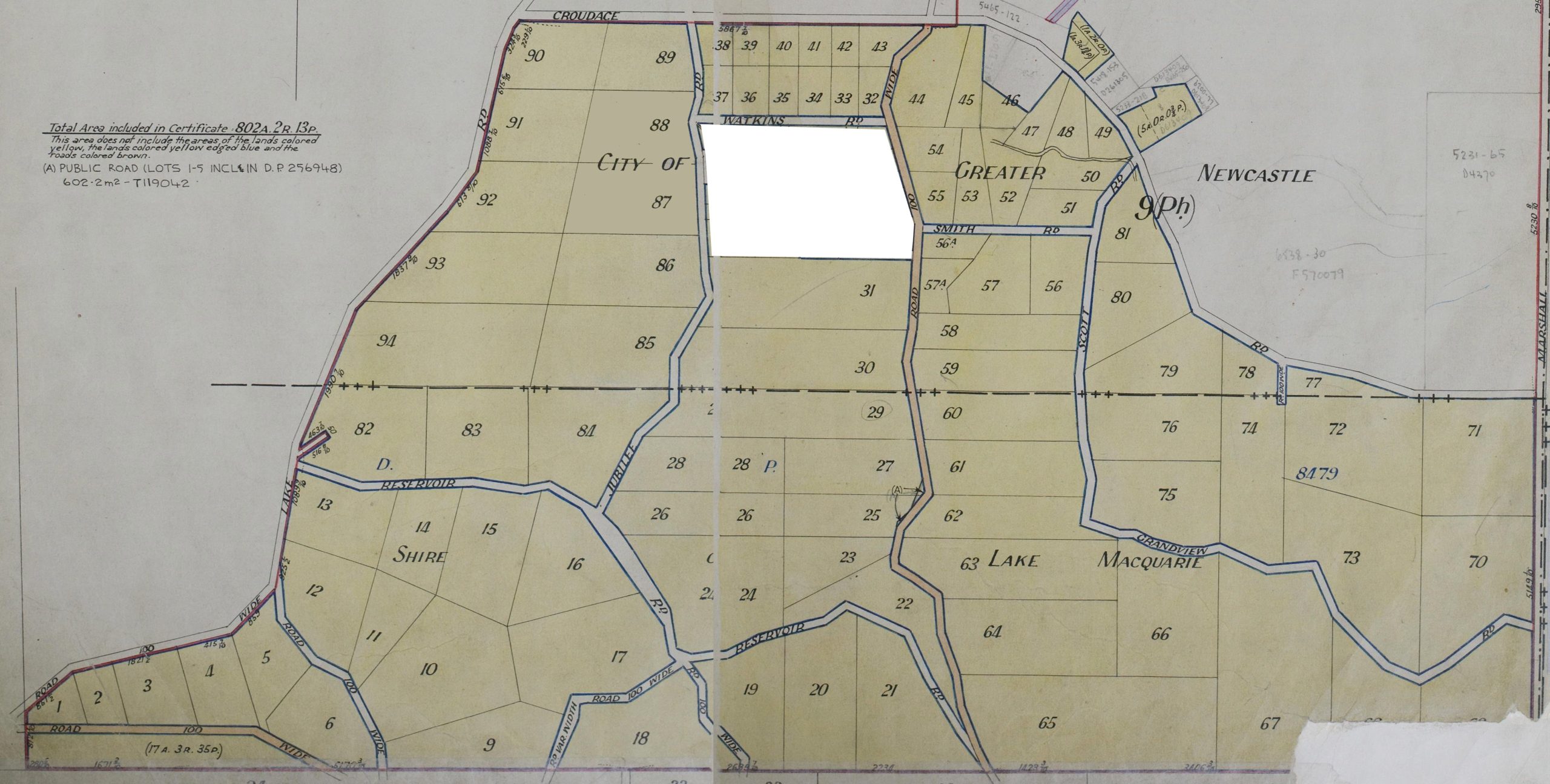
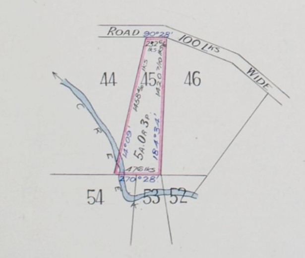
In August 1915, while he was manager, the Newcastle-Wallsend Coal Company registered a subdivision of a large area of their land with Deposited Plan 8479.
Lodgement entry for Newcastle-Wallsend Coal Company’s subdivision Deposited Plan 8479, in 1915. HLRV.
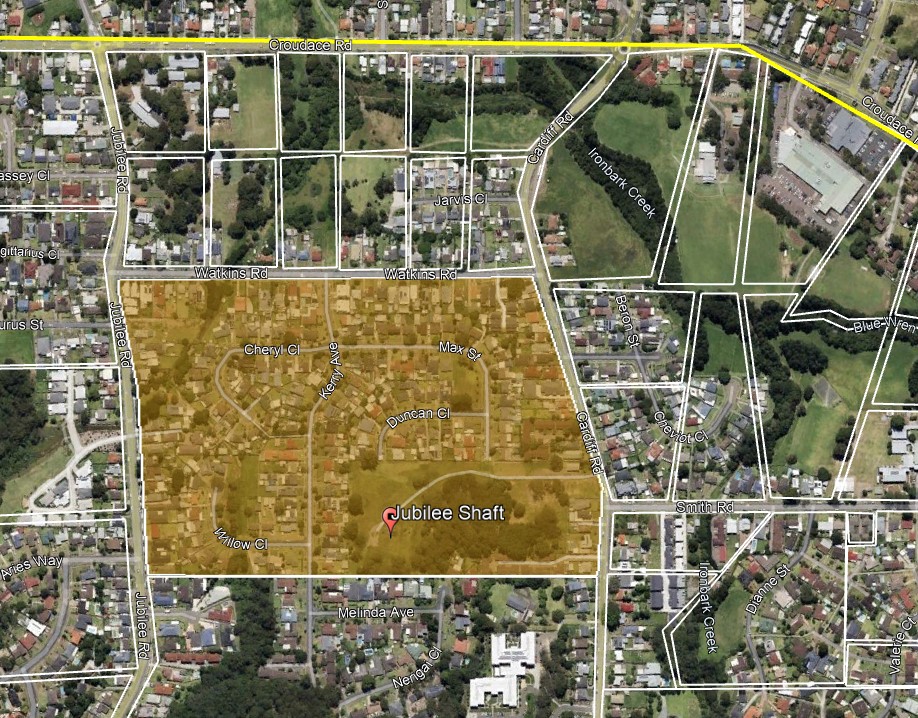
The subdivision, of approximately 1500 acres, covered the area between Wallsend, New Lambton and Cardiff. An area of about 50 acres was excluded from the middle of the subdivision, as this was the location of the Jubilee Shaft of the coal company. (More on this shaft later in this article.) The first land sale in DP8479 was to Henry Hancock for Lot 60 on 24 July 1916.
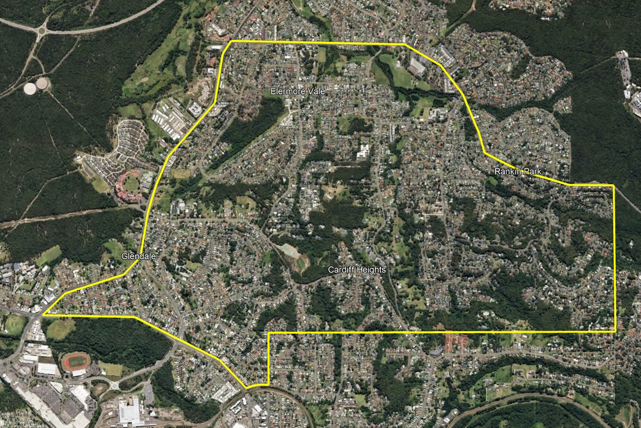
From land title Vol-Fol 5215-110, a map showing the lots in DP8479. The area shaded white was not included in the subdivision, as this is where the Jubilee Shaft of the Wallsend mine was located.Area of DP8479 shown in Google Earth.DP8479 extends over the area of six modern suburbs: Elermore Vale, Rankin Park, New Lambton Heights, Cardiff Heights, Cardiff, Glendale.
Just a few months after registering the subdivision, Sydney Croudace resigned as manager of the Newcastle-Wallsend Coal Company in December 1915 due to ill-health. The employees of the mine held a farewell dinner for Sydney Croudace, with both the office staff and the miners bestowing effusive praise upon him. By 1921 Croudace’s health had recovered sufficiently that he was able to resume the position of manager in February 1921.
By this time about 40 of the 94 lots in the subdivision had been sold. In July 1921 the residents in the northern part of the subdivision, known as Chinaman’s Flat, lobbied Wallsend Council to change the the name of their suburb, and to also set names for their as yet unlabelled streets.
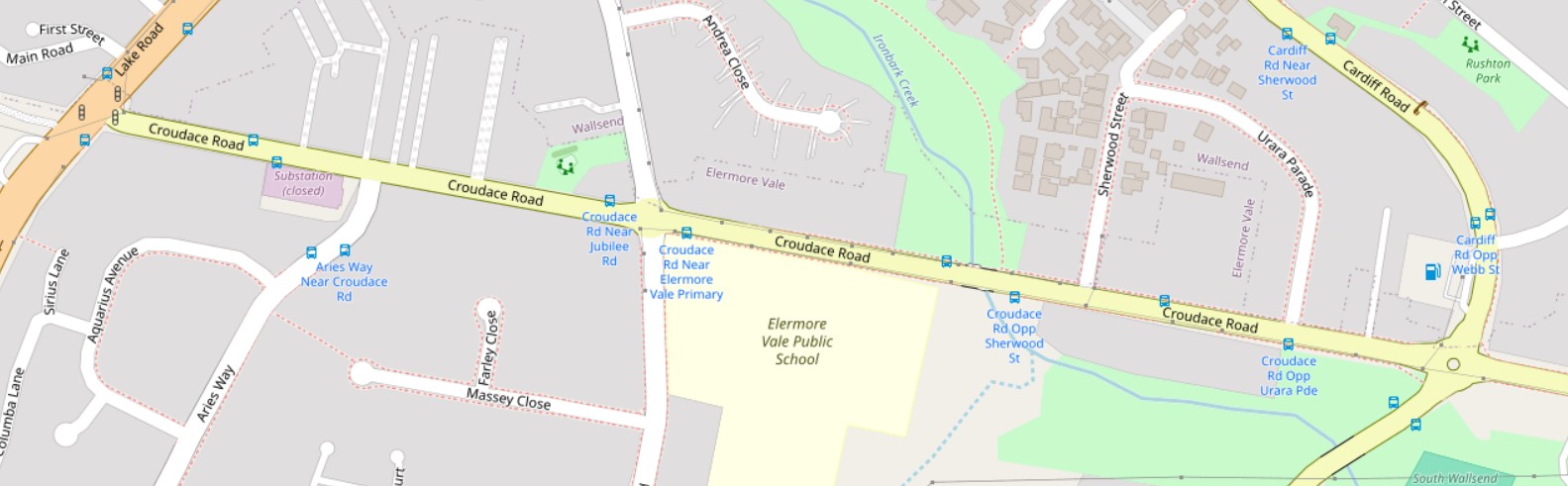
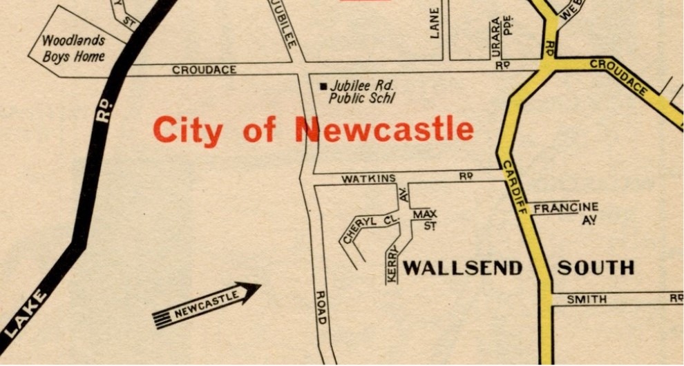
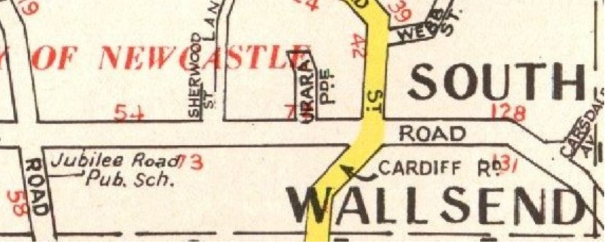
Chinaman’s Flat is by no means a high-sounding title for a progressive suburb. The residents of No. 2 subdivision, which is situated on the Lake road, near Wallsend, think it should be changed to something more Australian. They have asked Wallsend Council, through the Lake-road and Cardiff Progress Association, to erase the name of Chinaman’s Flat from all official records, and that the streets be named according to a list they supplied. South Wallsend was suggested as more appropriate. Alderman England said that the name certainly acted to the detriment of the place, and visitors were not favorably impressed who might otherwise have entertained the idea of purchasing land there. The names suggested are: Jubilee-street, Cardiff-road, Scott-street, Lake-road, Croudace-road, Smith-street and Watkin-street. The council agreed to all of the requests on condition that they be called roads.
Jubilee Road would have been named after the Jubilee shaft of the Newcastle-Wallsend Coal Company. The shaft was sunk in 1887, the year of Queen Victoria’s golden jubilee. The section of the road north of Croudace Road was originally called Lundy (Lundie) Street. In December 1953, at the request of the Lake Road Progress Association, Newcastle Council renamed that section to be an extension of Jubilee Road.
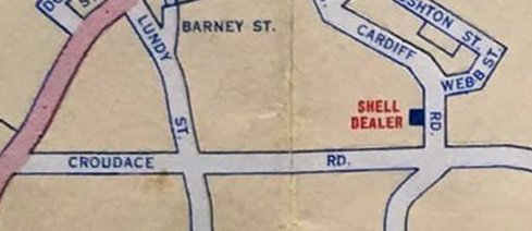
Cardiff Road is obviously named as for being the road from Wallsend to Cardiff. Although the residents requested this name, interestingly it was not formally granted at this time. As late as 1946 the road appears unnamed in land titles (e.g. Vol-Fol 5579-214.) Newspaper reports as late as December 1935 refer to the road as “Chinaman’s Flat Road”. By 1957 a Shell street map shows “Cardiff Road”, and land titles in 1959 (Vol-Fol 7753-30) now show “Cardiff Road”.
Scott Road – the inspiration for this name is unknown. It was later renamed to Grandview Road.
Lake Road was a name that was already used for that road further south in the Lake Macquarie Shire. The request by the residents here appears to be just an extension of that name further north into the Wallsend Council area.
Croudace Road was almost certainly named in honour of Sydney Croudace, who was manager of the Newcastle-Wallsend Coal Company when the subdivision was created in 1915 and the streets named in 1921.
Watkins Road is probably named after John Thomas Watkins, who purchased Lot 35 on that road in 1917.
Ministerial approval for the naming of Croudace, Smith, Watkin, Jubilee, and Scott Roads was received in December 1921.
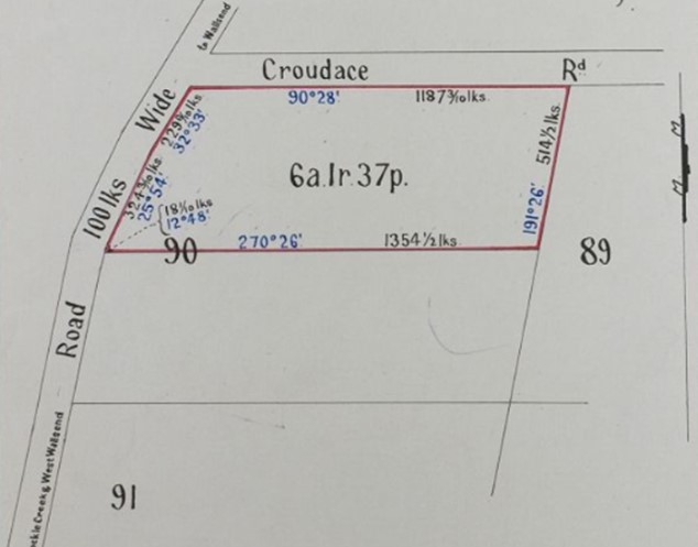
Prior to 1921, land titles in DP8479 just showed unnamed roads. Vol-Fol 2782-170.Land Title Vol-Fol 3327-139 in June 1922 is the first to show the name “Croudace Rd”.
A 1957 Shell Street map shows that Cardiff Road has now been officially named, however it still shows Lundy Street, although it had been renamed to Jubilee Road in 1953.
Sydney Croudace finished as manager of the Newcastle-Wallsend Coal Company in October 1928, and moved to a property in Brighton Avenue, Toronto where he lived until his death on 3 February 1935 at the age of 61. Co-incidentally, his death came just one week after shareholders of the Newcastle-Wallsend Coal Company voted to cease operations at the Wallsend Colliery that Croudace had managed for ten years.
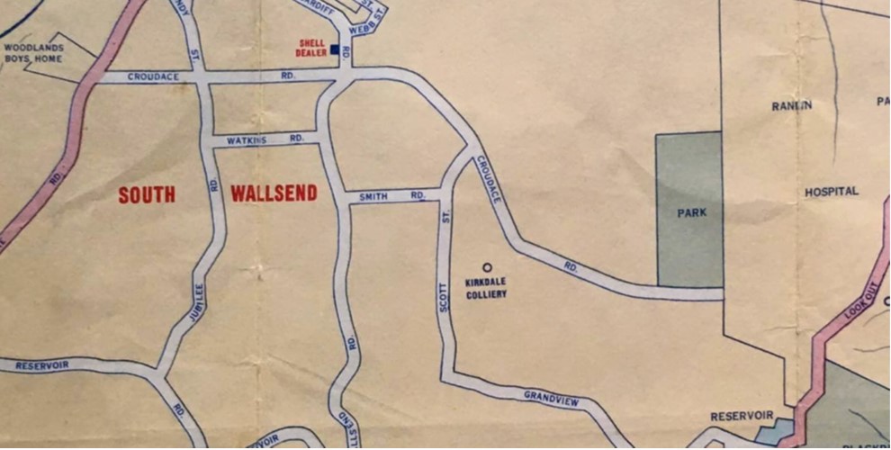
In the ensuing years the suburb adjacent to his namesake road was variously called “South Wallsend” and “Wallsend South” in equal measure.
A 1957 map with the suburb labelled “South Wallsend”.The 1970 Gregory’s Street Directory has the suburb labelled “Wallsend South”.The 1973 Robinson’s Street Directory has the suburb labelled “South Wallsend”.
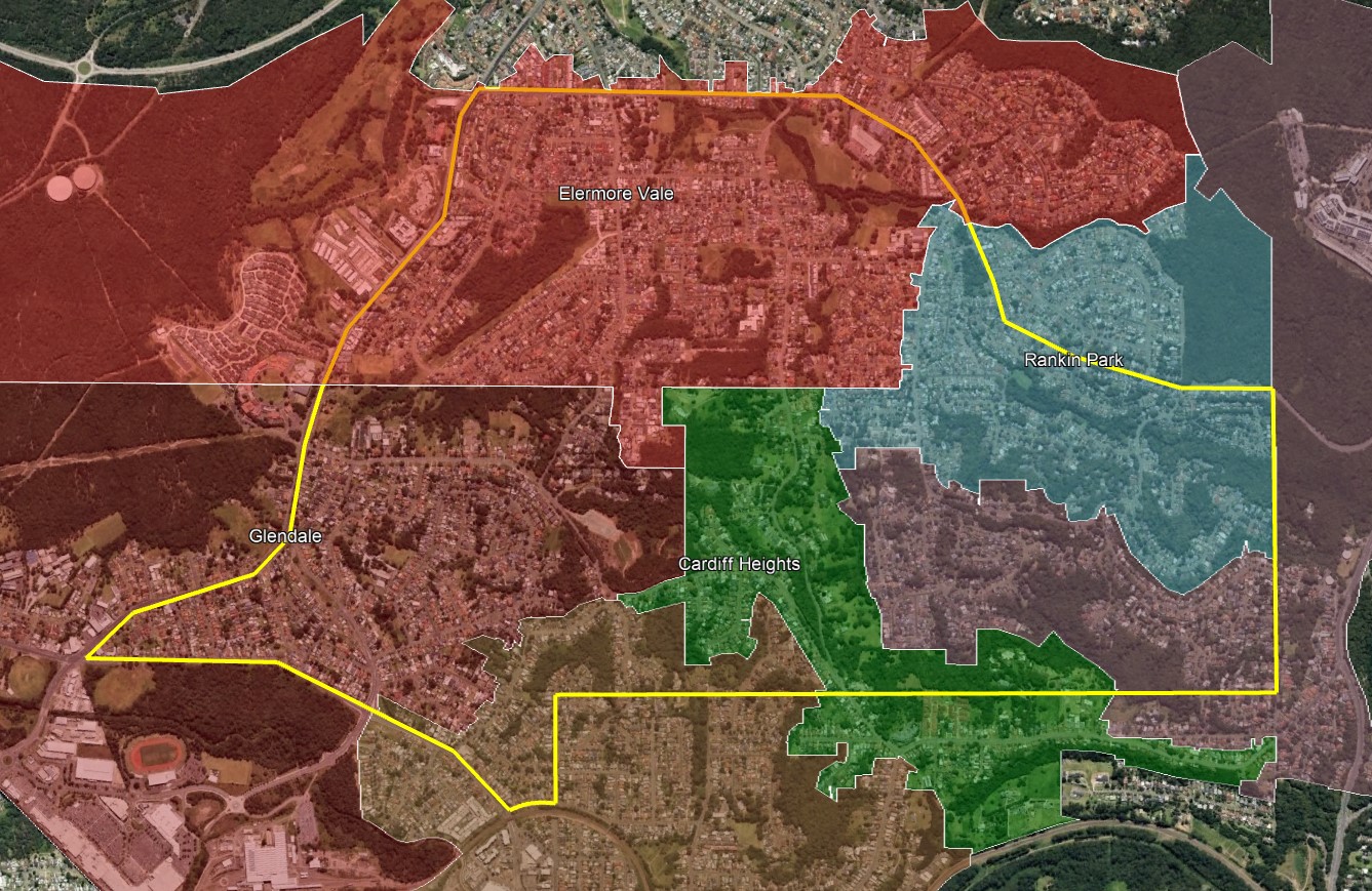
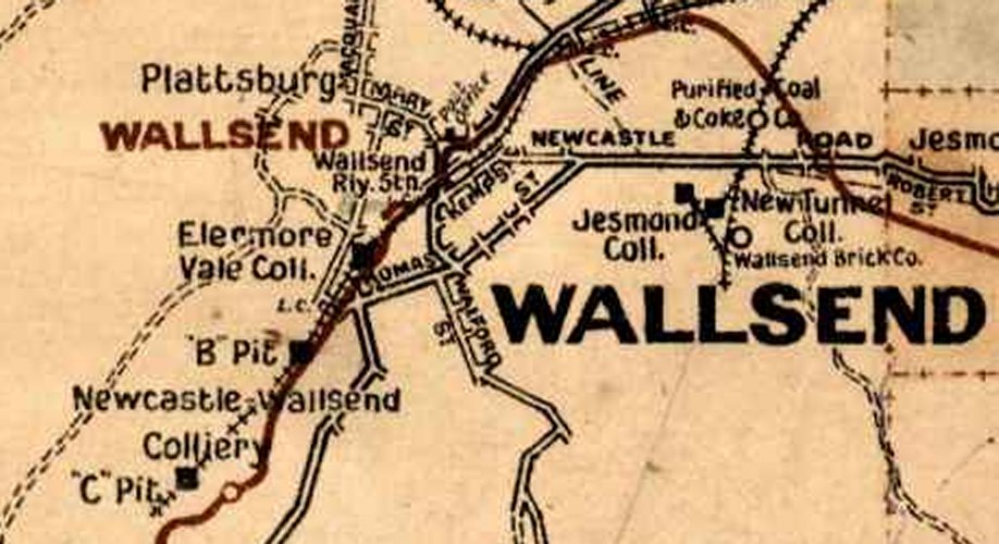
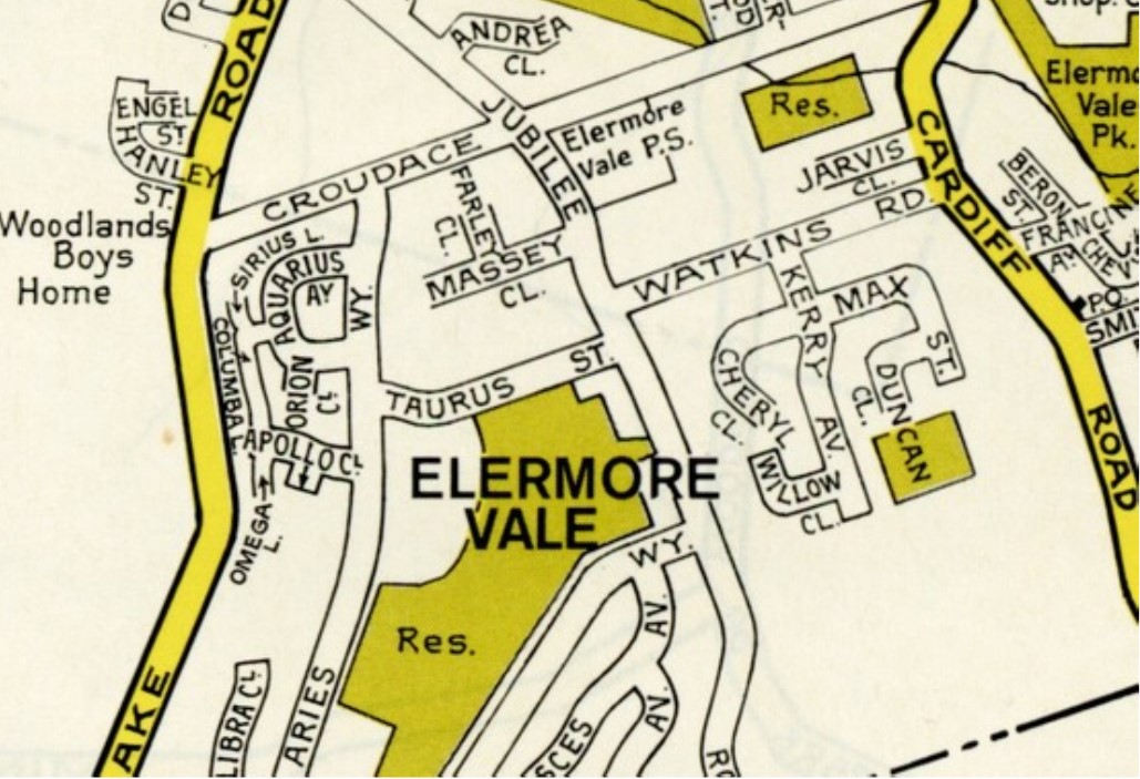
On 14 November 1975, the suburb name was officially changed to “Elermore Vale”, probably in reference to the Newcastle-Wallsend Coal Company’s “A pit” that opened in Wallsend in 1859, which was also known as the “Elermore Vale Colliery”.
1920s Craigies map showing the A pit of the Wallsend colliery labelled as “Elermore Vale Colliery”. Newcastle University, Living Histories.Somewhat confusingly, the area of the modern day Elermore Vale suburb (shaded red) does not include the location of the original Elermore Vale Colliery.The 1984 UBD street directory shows the new suburb name “Elermore Vale”, and the former “Jubilee Rd Public School” is now labelled “Elermore Vale Public School”.
Jubilee Shaft
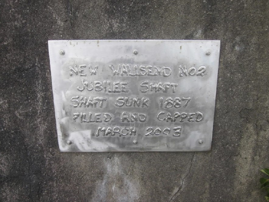
In 1887 in the year of Queen Victoria’s golden jubilee, the Newcastle-Wallsend Coal Company sunk a new shaft to assist with ventilation of their mine, and named it the Jubilee Shaft. It was located inside the area that was later subdivided in 1915 as DP8479, and thus was excluded from that subdivision.
The area shaded orange was excluded from DP8479 in 1915, as it was the location of the Jubilee Shaft.
In the early 1930s the Wallsend Colliery struggled to be profitable, and in November 1934 the owners advertised the colliery for sale or lease. When no acceptable offers eventuated, the shareholders voted in January 1935 to close the mine and sell off the colliery plant, machinery, waggons and railway. Surplus equipment from the Jubilee shaft was sold at auction in May 1935. The land in the vicinity of the shaft then began to be subdivided and sold off, however a smaller parcel of land around the shaft was retained by the coal company.
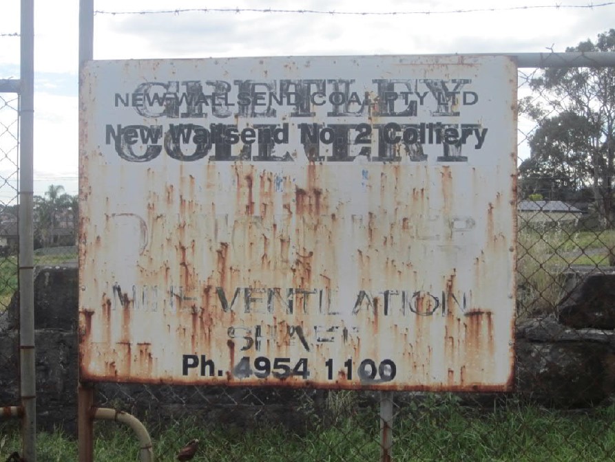
After the closure in 1935, the coal seams were worked by various tribute collieries until 1968, when the Newcastle-Wallsend Coal Company resumed operations at Wallsend under the new name of “Gretley Colliery”. The name was a combination of two coal seams the company was mining – the Greta Seam in their Pelton and Ellalong mines, and the Dudley seam they were working at Wallsend. In November 1996 tragedy struck at Gretley mine when four miners were drowned by a sudden inrush of water when they inadvertently broke through to flooded abandoned workings adjacent to the Gretley workings. The error was due to the mine having been supplied with incorrect plans of the old workings by the Department of Mineral Resources. Work at Gretley was immediately suspended. In 1999 Gretley was bought by New Wallsend Coal Pty Ltd, who operated the workings as “New Wallsend No. 2 Colliery.”
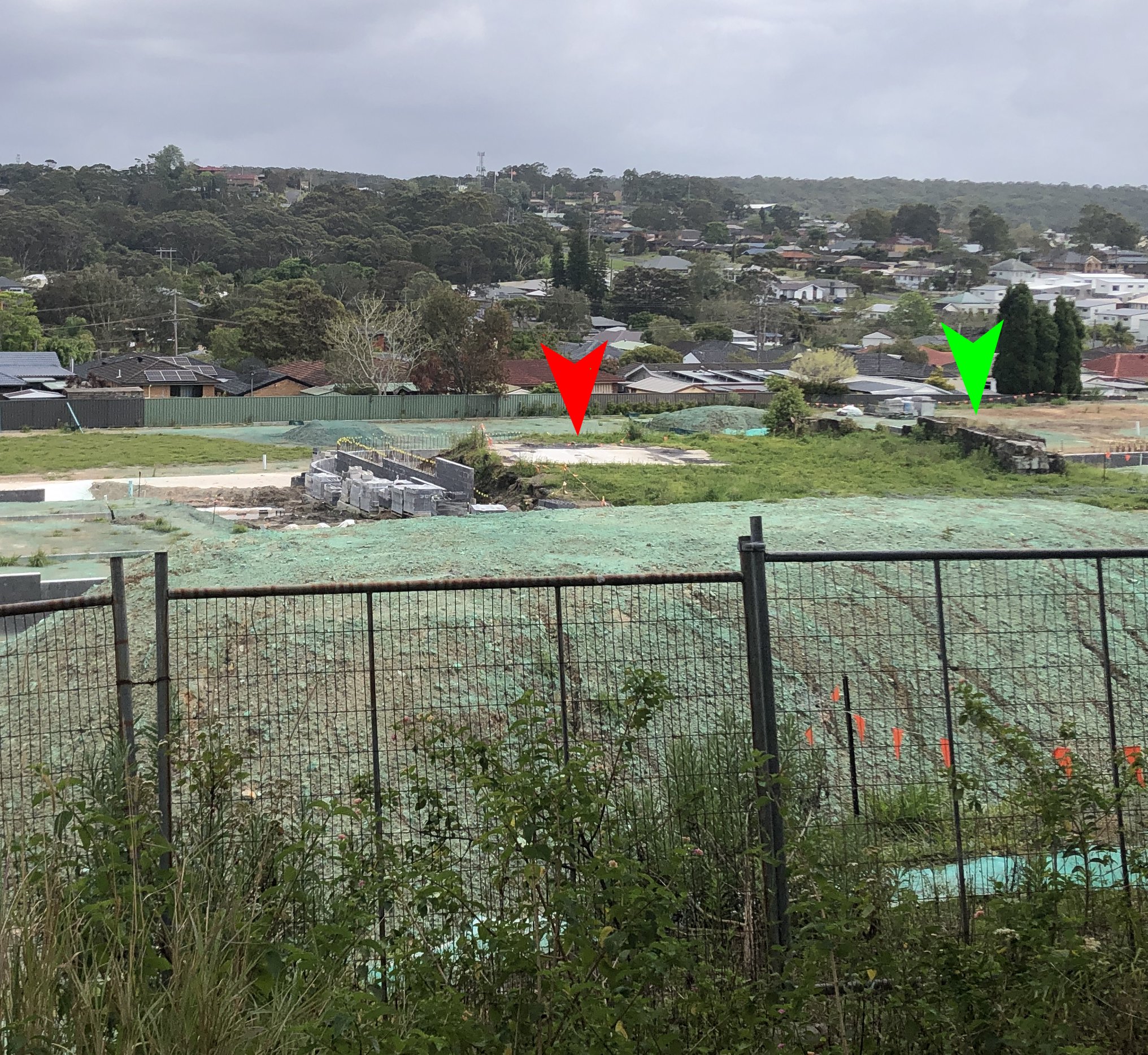
A partial history of the Jubilee Shaft site can be seen in the photo below, the sign on the enclosing fence shows “Gretley Colliery” overstamped with “New Wallsend Coal Pty Ltd, New Wallsend No. 2 Colliery.” At the bottom of the sign, the words “Mine Ventilation Shaft” are just visible.
In 2021 Newcastle Council approved a development application for the construction of a 50 lot Community Title subdivision on the former Jubilee Shaft site. The development will retain some of the remnant Jubilee Shaft sandstone building walls in a community area
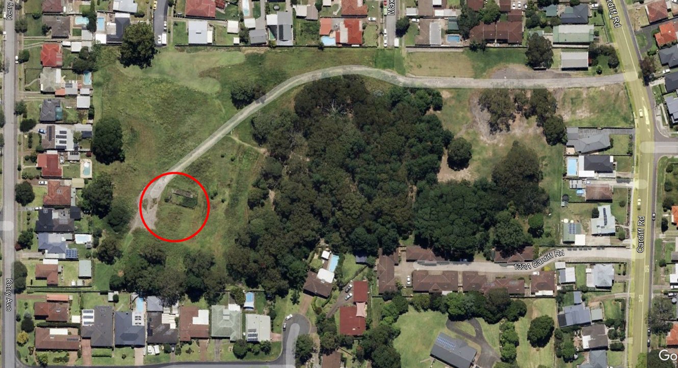
In 2022, the area around the Jubilee Shaft was still mostly vacant, and some remains of the mine buildings were still present.In October 2024, the concrete capped shaft (red) and remnants of a sandstone wall from an old mine building can be seen in the midst of the development of 50 new housing units.
Croudace Road in Edgeworth
In the original iteration of this blog post I posed the question of why there is a Croudace Street in Edgeworth? Thanks to a note on page 138 of Ed Tonks’ 1990 book “Wallsend and Pelton Collieries. A Chronology of The Newcastle Wallsend Coal Company”, I have the answer.
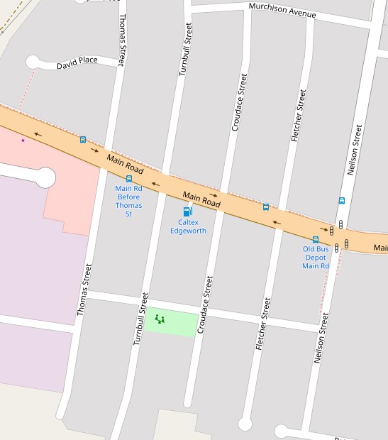
That area of Edgeworth has five north-south streets, all named after prominent colliery managers of the Newcastle district when that subdivision was created in 1885.
Turnbull Street – named after William Turnbull, manager of the Australian Agricultural Company’s collieries.
Croudace Street – named after Thomas Croudace, manager of Lambton Colliery.
Fletcher Street – named after James Fletcher, manager of the Co-operative Colliery at Wallsend.
Neilson Street – named after John Young Neilson, manager of the Newcastle-Wallsend Coal Company.
Street names in Edgeworth named after colliery managers. OpenStreetMap.
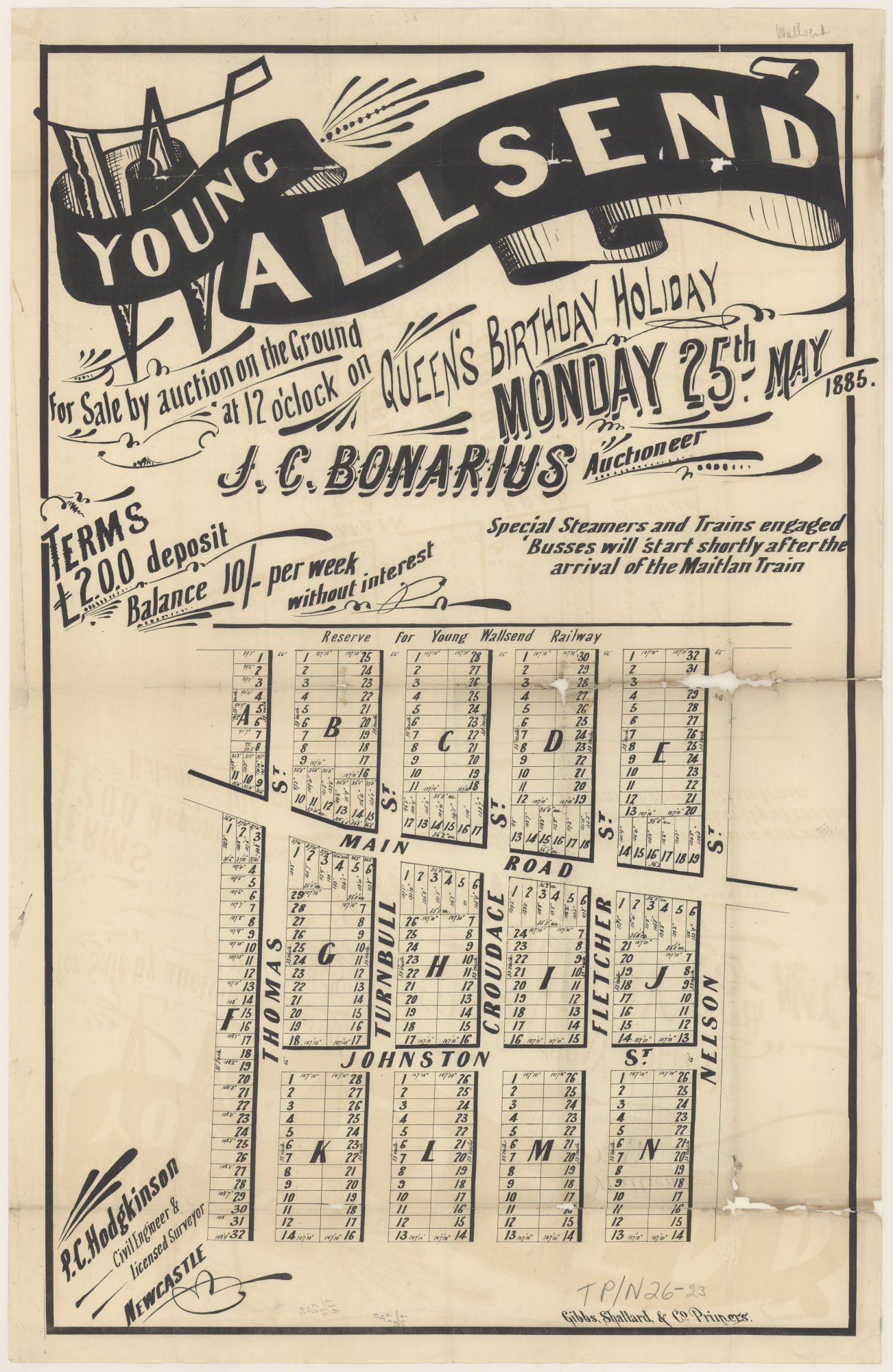
Edgeworth was originally called “Young Wallsend”, and the subdivision created by John Charles Bonarius was described by the Newcastle Morning Herald and Miners’ Advocate on 16 May 1885 …
The subdivision has been laid out by Mr. Percy Hodgkinson, of this city, whose abilities in laying a township are well known to everyone in the district, and is under the supervision of Mr. John C. Bonarius, our oldest and well-esteemed auctioneer, who will wield the hammer at the sale. The streets are plainly seen. Large posts, with the names Neilson, Fletcher, Croudace, Turnbull, Thomas, and other notables connected with the coal trade of Northumberland are seen.
Newcastle Morning Herald and Miners’ Advocate, 16 May 1885.
A real estate poster advertising the sale of the subdivision was produced, but with Neilson and Johnson spelled incorrectly.
Retirement due to ill-health of Sydney Croudace as manager of Wallsend colliery.
"There was a large attendance at the Masonic Hall, Wallsend, on Saturday evening, when Mr. S. Croudace, who for the last three years has occupied the position of manager of the Wallsend Colliery, was entertained by the employees of the colliery, and presented with marks of their esteem and appreciation."
"Mr. S. Croudace will succeed Mr. N. J. Clark as colliery manager of the Newcastle-Wallsend Coal Company." (Croudace returns to the position he previously resigned from due to ill-health.)
"Ministerial approval having now been received, it is notified for public information that the un-named roads in the South Wallsend subdivision, otherwise known as Chinaman Flat Subdivision, will be designated as follows: Croudace-road, Smith-road, Watkin-road, Jubilee-road, Scott-road."
"At the annual general meeting of shareholders of the Newcastle-Wallsend Coal Company held yesterday it was decided to cease operations at the company's Wallsend colliery owing to heavy losses incurred during the past six years and the uncertainty of the future."
"Hopes of a reopening of Wallsend Colliery, commonly known as Wallsend C Pit, have been shattered … dismantling and removal to the surface of the underground appliances and plant of the colliery. … The mine is to be abandoned."
"Wallsend citizens who have been hoping for an 11th-hour sale of the colliery property, or for a lease which would allow a resumption of operations, are beginning to despair as they realise the latest definite steps Newcastle-Wallsend Coal Company has adopted to seal the doom of Wallsend C pit. For three-quarters of a century the coal company has been operating at one or another of the branches of its Wallsend mine. Wallsend without a Wallsend colliery is to many people almost unthinkable."
"Newcastle Council Works Committee recommended last night that the council alter the name of Lundy-street, Wallsend, between Lake-road and Croudace-street, to Jubilee-road. The City Engineer (Mr. Baddeley) said a month had passed since the council proposed to alter the name. It had been publicised and no objection had been received."
When the old Lambton colliery ceased operation, the pit paddock with its offices and buildings lay idle for a decade. Then 75 years ago, in 1947, a new enterprise began on the site with the opening of Leonora Glass Industries, founded by David Marr and three highly skilled Czechoslovakian glass workers.
Joseph and Henry Vecera and Josef Tvrdik came to Australia from Europe in 1934 to teach glass making at a Sydney factory. They later moved to Newcastle to work in the Electric Lamp Manufacturers Australia factory at Hamilton North. In 1946 the three men and their families became Australian citizens. The following year, along with David Marr (manager) and Alan Little (engineer), they set out to create their own glass making business, renting a portion of the Lambton colliery and setting up furnaces in the former colliery workshop.
In August 1947 they registered their enterprise as “Leonora Glass Industries”, possibly inspired by the town of Lenora in the Czech Republic, just 30km from Josef Tvrdik’s birthplace, where a famous glassworks had operated since 1834. Manufacturing commenced the following month and by December 1948 the works employed 23 people including several young apprentices. At this time they were making 2000 lamp shades a week. In the following years they produced many items such as wine glasses, dishes, ash trays, and car headlight lenses.
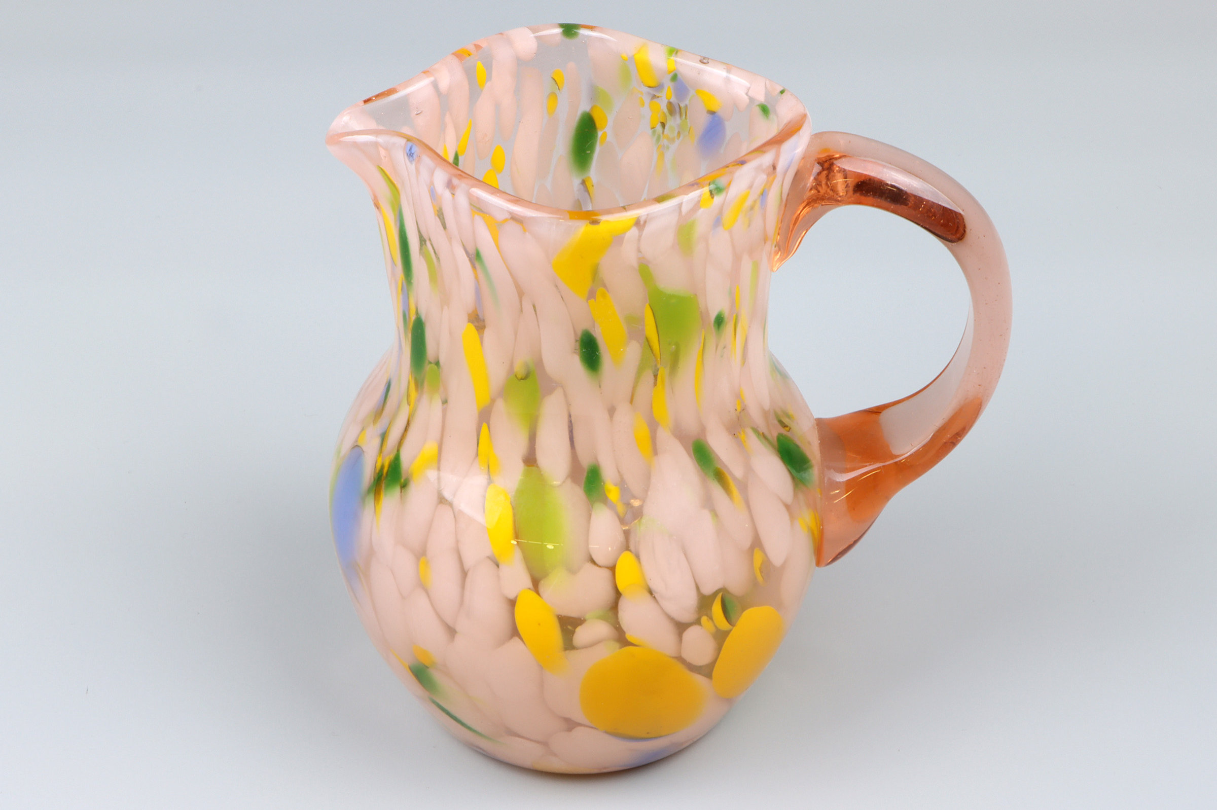
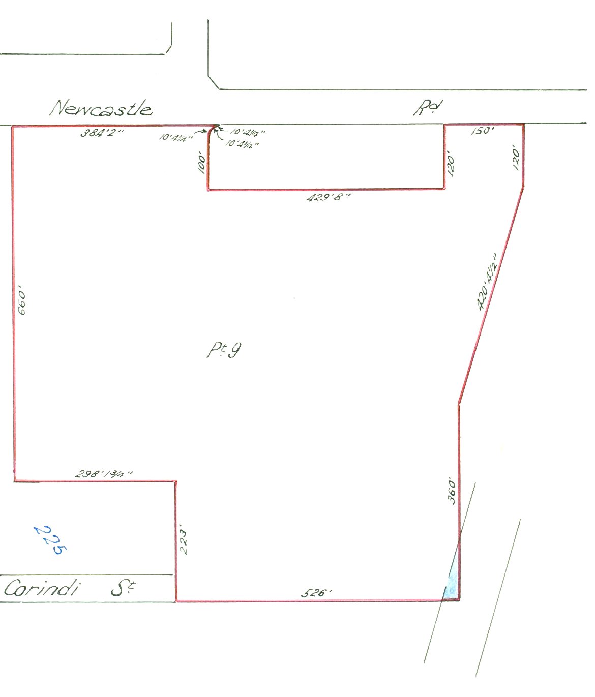
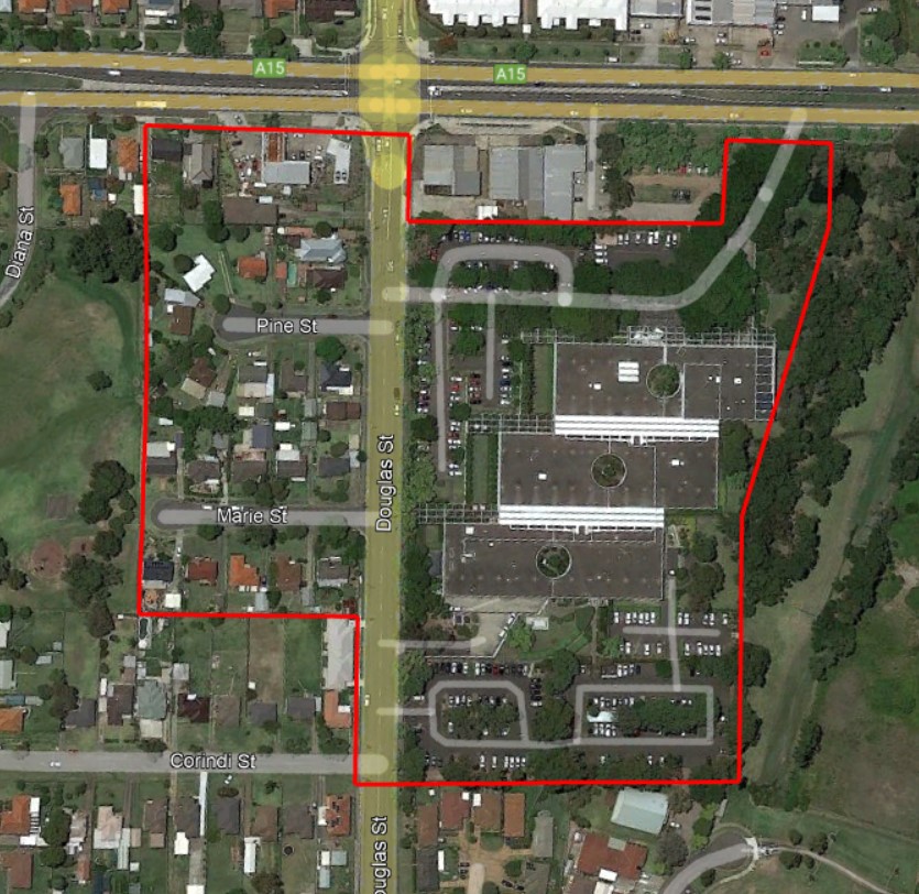
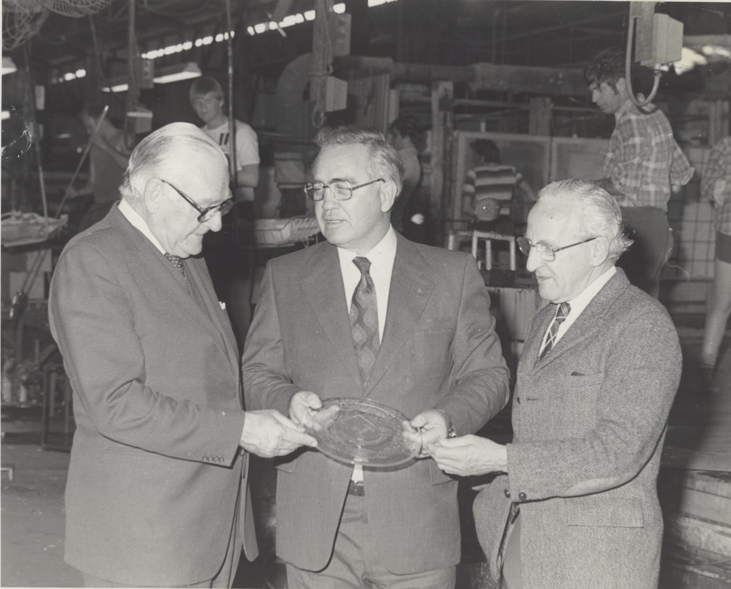
While the bulk of Leonora’s output was utilitarian in nature, they also handcrafted fine glassware such as jugs, vases, and decorative ornaments. Museums across Australia hold examples of these works in their collections. In July 1957 glassmaking in Lambton came to an abrupt halt when a fire destroyed the Leonora works. The company quickly recovered, purchasing 14 acres of land on Douglas St Wallsend to set up a new factory. In 1960 the multinational firm Philips Industries took over the glassworks to focus on the manufacture of light fittings. Although business expanded in the 1960s, increasing pressure from low cost overseas competitors in the 1970s led to the eventual closure of the works in 1982
The article above was first published in the October 2022 edition of The Local.
Additional photos
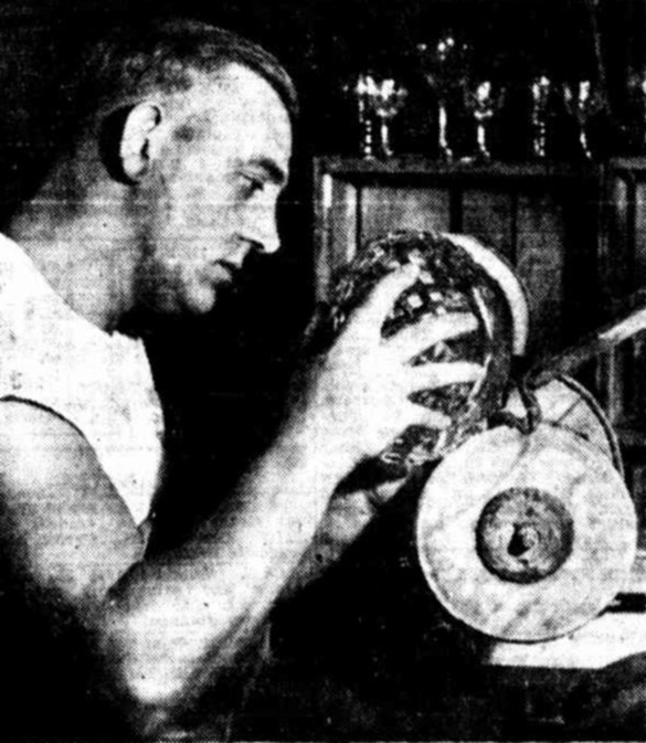
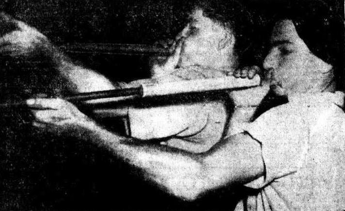
Gordon Maybury, of Wallsend, and Sid Bennet, of Cardiff (rear), grind lamp shades at the Leonora Glassworks. Newcastle Morning Herald and Miners’ Advocate, 3 Dec 1948.Mr. Ernest Sandgren cutting glass at Lambton fine glass factory. Mr. Ernest Sandgren, Newcastle’s only cutter of fine crystal, was Australia’s weightlifting champion for seven years. Newcastle Morning Herald and Miners’ Advocate, 11 Dec 1948.Milon and Joseph Vecera, 19 year-old twins blowing glass at a Lambton glass factory. Newcastle Morning Herald and Miners’ Advocate, 8 Mar 1950.
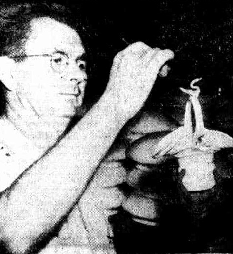
Mr. Henry Vecera finishes off a piece of hand made glassware. Newcastle Morning Herald and Miners’ Advocate, 8 Mar 1950.
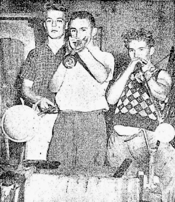
Three Newcastle youths, from left, Des Williams, George Kildey and Ron Jones, training at a Lambton glass factory yesterday to be glass-makers. Newcastle Morning Herald and Miners’ Advocate, 26 May 1953.The 15 acres of land in Wallsend, purchased by Leonora Glass Industries in October 1957, to build a new glassworks after the Lambton glassworks was destroyed by fire. Vol-Fol 7697-17.The area of the 1957 purchase of land, shown in Google Earth.
A 1966 aerial photograph, showing the glassworks in Douglas St Wallsend. NSW Historical Imagery.
Wife, Cecile; twin sons, Milon Edward and Joseph Henry, born 1931
Wife, Coralie Violet Mary
Company information
A search of the ASIC Registers shows that Leonora Glass Industries Pty Ltd was registered as a company on 11 August 1947.
Origin of the Name Leonora
I have no direct evidence for the naming of “Leonora Glass Industries”, and what follows is just a reasoned guess.
We know from the notification of intention to apply for naturalisation, that Josef Tvrdik was born in “Nova Hut” in Czechoslovakia. This is the village of Nové Hute in the Czech Republic today.
The villages of Nove Hute and Lenora in Czechia, are 17km apart (26km by road). OpenStreetMap
Just 17km away (28km by road) from Nove Hute is the village of Lenora. The tourism website for the Šumava region describes the origin of the town.
The village of Lenora was founded as a settlement around one of the last glass- works established in the Šumava mountains by Jan Meyer in 1834. Later on the glass-works were taken over by Meyer’s nephew Vilém Kralik. The village was named Eleonorenhain after the Princess Eleonora (1812-1873), the wife of the lord of the estates John Adolf of Schwarzenberg. Czech translation of the name is “Eleonora’s Paradise”. Later on the village adopted Czech version of the name, Lenora.
Notice of intention by Henry Vecera, Josef Vecera, and Josef Trvdik to apply for naturalisation.
Josef Tvrdik, born at Nova Hut, Czechoslovakia, resident over 11 yers. Josef Vecera, Born at Uhrovec, resident over 11 years, living in Adamstown. Henry Vecera, Born at Uhrovec, resident over 11 years, living in Pearson St Lambton.
"A GLASS factory, now operating in a disused building which once was part of the Old Lambton coalmine, aims to produce the finest glass and crystal ware. The company--Leonora Glass Industries Pty. Ltd.- comprises Messrs. Jospeh and Henry Vecera, Mr. Jospeh Tvrdik. Mr. David Marr (manager) and Mr. Alan Little (engineer). Messrs Vecera and Tvrdik are Czech-Australians, who came to Australia in 1934 to teach glass-making at a Sydney factory."
“The strange bulbous Dali-like shapes, coloured in streaky and marbled patterns, which yesterday made an appearance as part of the Christmas dressing of a Hunter-street store are not painted marrows or solid-seeming balloons ... they are made of glass. The result of a brain-wave on the part of the window dresser (Miss E. Ritchie), they were specially blown at the Leonora Glass Works at New Lambton.”
The development of the fine glass industry in Newcastle by two Newcastle engineers and three Czechoslovakian glassworkers in a factory at Lambton is giving Newcastle boys an opportunity
to learn the trade. The factory, which employs 23 after 12 months of operation, turns out 2000 lamp
shades a week and some 400 water sets. Production of fine glass-wine glasses and ground glass-is starting.
Story on Ernest Sandgren, immigrant from Sweden, and Australian weight-lifting champion for 7 years, working as a cutter of fine crystal at Leonora Glassworks.
"It was planned with the Leonora glass factory at Lambton to make Newcastle a centre of the fine glass
industry in Australia, the Managing Director (Mr. D. Marr) told Newcastle Business Men's Club yesterday. The factory was still in its initial development. It had been operating for 18 months. In the factory there were three Czechs of world-wide experience in the manufacture of hollow blown ware, including the art of stemware. They came from generations of art craftsmen."
“The factory is now producing heat-resistant glass in large quantities. About 100,000 such articles have been produced for distribution throughout Australia, in the past 12 months. The Manager (Mr. David Marr) said he believed this was the first time pyrex-type glass had been made in Newcastle.”
"MILON and Joseph Vecera, twin sons of Mr. and Mrs. J. Vecera, of Croudace street, Lambton, celebrated
their 21st birthday, which was on New Year's Day,' with a party, on New Year's Eve. About 40 people attended the party. Milon and Joseph, who were born in Lausanne, Switzerland, came to Australia when they were four. They are both glass craftsmen at Leonora Glass Works, Lambton, and both play the piano,
violin and piano-accordion."
The factory is turning to a new type of glass manufacture for Newcastle. This is the manufacture of pressed glass. A glass moulding press has been installed to manufacture pressed glass dishes, car headlight lenses, ash trays and other goods. The machine is in trial production. When producing fully, it will turn out 1500 articles a day.”
Today’s post comes from Dan Rees St, Wallsend. From 1910 the tram line was extended out from this point to West Wallsend, but the extension was closed in November 1930. At the time this photo was taken (1940s) this was the tram terminus in Wallsend.
Old tram photo from the University of Newcastle, Living Histories.