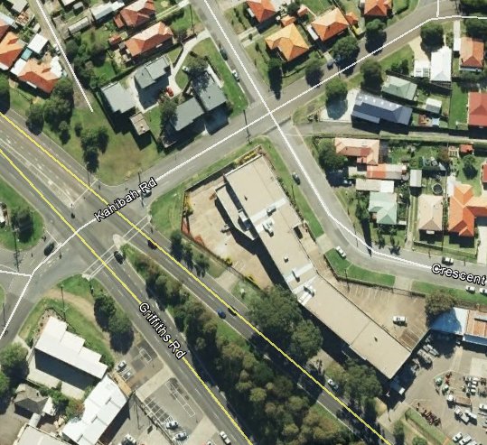
I love old maps. They are like a time machine allowing us glimpses of our past environment, and occasionally it is surprising to discover that something long gone has affected the shape of our present urban landscape. A good example is the area where Acacia Ave meets Griffiths Rd today.
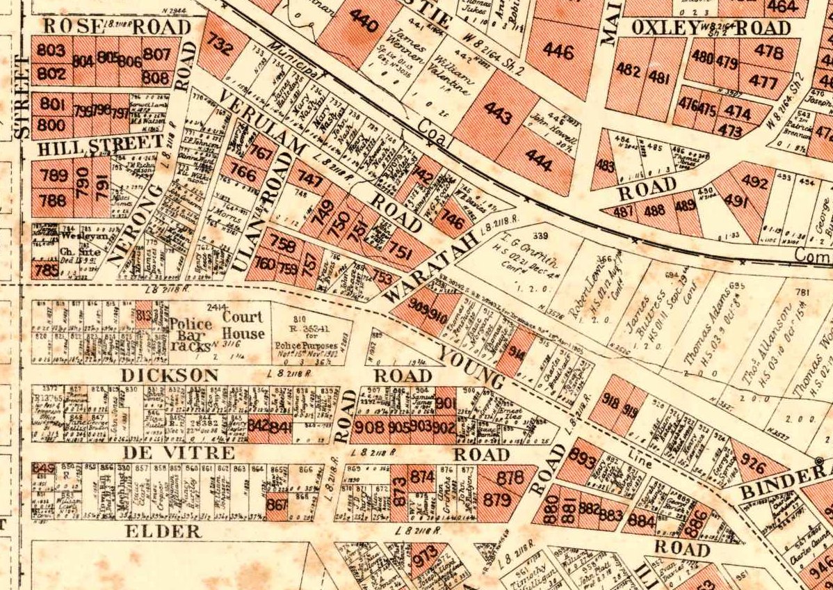
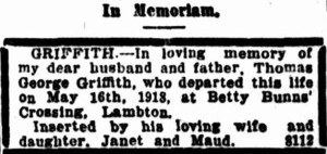
The map above is from a 1906 poster advertising land for sale (the shaded areas) and shows that the Waratah Coal Company railway once ran along the present day Acacia Ave and a section of present day Griffiths Rd. What is now Lambton Rd and Traise St, was originally Waratah Rd which intersected the colliery railway at a spot known as “Betty Bunn’s Crossing”. The map reveals other interesting details such as the location of the Lambton Courthouse on Dickson St, and the names of various land owners along the rail line, such as T.G. Griffith.
But as with much historical research, old maps can pose as many questions as they answer. Lloyd Rd is shown in a dotted outline extending across Lambton Park. Was this a road that once was and is no more, or a road that once was meant to be, but never was? Why was the railway intersection known as Betty Bunn’s Crossing? Was Griffiths Rd named after T.G. Griffith?
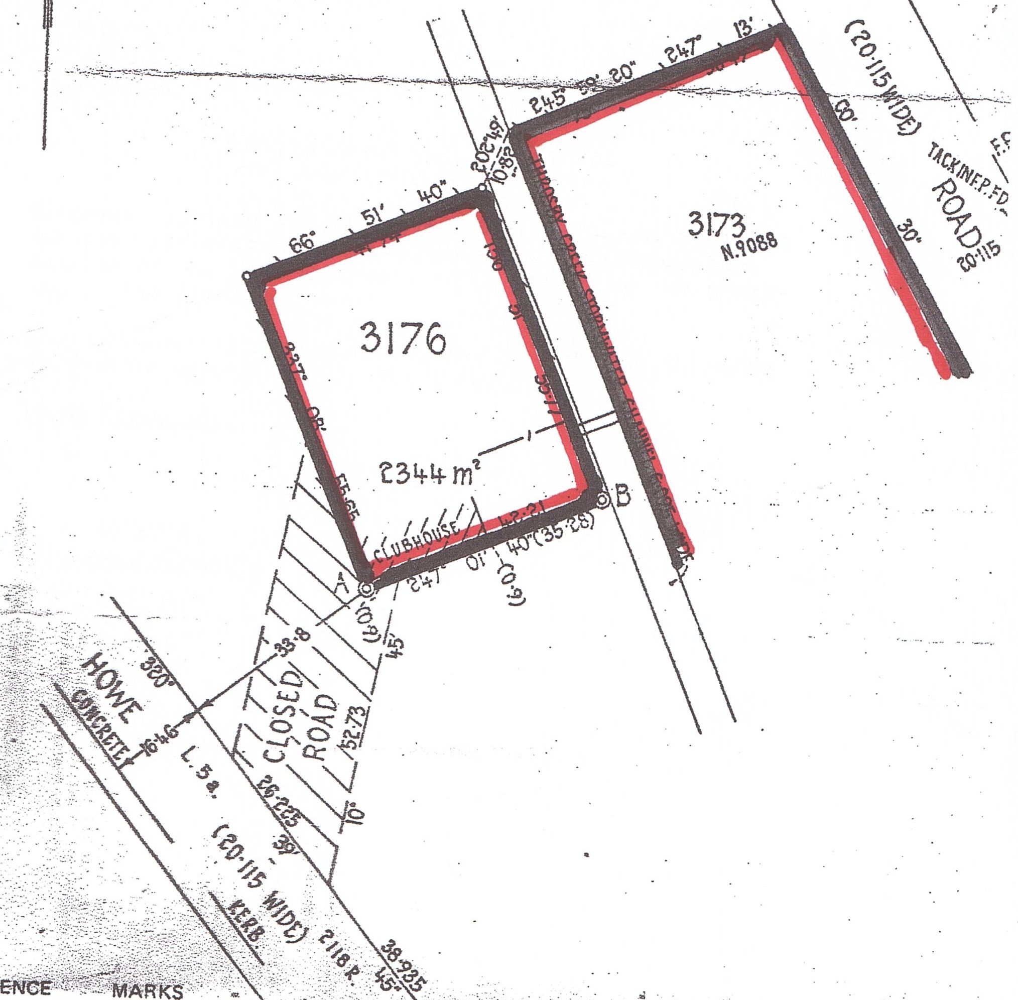
For all these questions, there is one answer that I find most satisfying. On the corner of Griffiths Rd and Kahibah Rd there is a building with a bend, because the block of land is bent, because it was once hemmed in by the railway. I worked in that building for 17 years, never once realising that the funny little kink in the middle owed its existence to a colliery railway that was removed over a hundred years ago. The past does indeed cast long shadows into curious places in the present.
The article above was first published in the January 2016 edition of the Lambton Local.
Further information
- The 1906 map of Lambton is from a real estate poster in the University of Newcastle Cultural Collections photo archive on Flickr. There are over 800 other real estate posters from this era in their collection, and to assist in locating items from particular areas, using Google Maps I have put together a visual index to the historical real estate maps.
- Although the 1906 map shows the Waratah Colliery railway line still in place, it seems that by this time it was no longer in use. Back in November 1904 the Mayor of Lambton “suggested that the Waratah Coal Company be asked to remove a length or two of rails where the old quarry rail-way crossed the Waratah-road.”
Waratah council was also asked in December 1904 to cooperate with Lambton council in this matter. The rail corridor was officially resumed by the Government in the Newcastle Pasturage Reserve (Railways) Resumption Act of 1915. - There are a number of newspaper articles that refer to Betty Bunns Crossing, as recently as June 1954.
- Thomas George Griffith of Betty Bunns Crossing died 16 May 1918, aged 73.
- The 1906 map also shows a number of other interesting things.
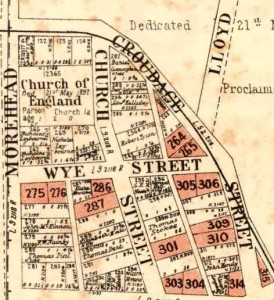
- The road on the south-western border of Lambton Park (now Howe Street) was once Croudace Street.
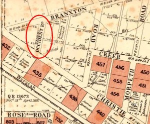
- Christo Road was once Christie Road.
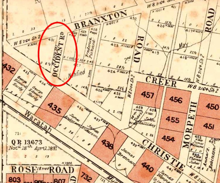
- There was at one time an Occident Road, running off Christie road. This is the missing compass point street name to Boreas St, Orient St, and Australia Rd in nearby Broadmeadow and Hamilton North.
- The road on the south-western border of Lambton Park (now Howe Street) was once Croudace Street.


The Question of Lloyd Road
In the article I mention that the 1906 map shows Lloyd Road as a dotted outline crossing Lambton Park, and ask whether this a road that once existed and was removed, or a road that was planned but never built?

Although there is no conclusive evidence, my own view is that the section of Lloyd Rd across Lambton Park was never built. My reasons are …
- Of all the old maps I have of this area, about half show this section of road, and about half omit it. Of those that show it, most of them show it in a dotted/dashed outline.
- None of the old photographs I have seen of Lambton Park show any evidence that a road was once there.
- In the Lambton Municipal Council meeting in September 1886, there is a reference to this section of road in a letter to the district surveyor …
To District Surveyor Allworth, respecting Reserve, pointing out that the surveyors were at work, and that the council had been informed that instructions had been given, to retain Lloyd-street as shown through the reserve on plan. The council held that this street was not required, and that it would spoil the appearance of the Reserve by cutting it into two portions and occupying a considerable amount of surface.
Although the wording is somewhat ambiguous, two things suggest to me that Lloyd Rd through the park was not a reality on the ground. Firstly the instruction to retain Lloyd Street as shown “on plan“. And secondly, the use of the future tense in saying that Lloyd St “would spoil the appearance”.
- Another indirect reasoning that makes me think Lloyd Rd never ran across the park is by asking the question ‘Who built and paid for the road if it existed?’ Prior to its dedication as a park in 1887 this land was part of the Newcastle Pasturage Reserve (or Commonage), not part of Lambton Municipality. Lambton council was having enough trouble building and maintaining roads they were responsible for, so I cannot imagine the council would have built a road on land they weren’t responsible for. Thomas Croudace in his nomination speech for New Lambton Council in 1889 even says that for a council “it would be illegal to form and make streets on that land.” As for the State Government, the consistent picture at this time is that they are all talk and no action when it comes to doing anything with the reserve. If it took them over ten years just to do the paperwork in gazetting Lambton Park, it is inconceivable that they would have spent any effort or money in building a road there.