
Acknowlegement. This little adventure was inspired by the book by Peter Armstrong, “Looking Up The Gully Line – A History Of The Waratah Colliery”. Much of the information in this post is sourced from this book.
On the 22nd December 1961, the final whistle blew on the final shift at the Waratah Colliery and all but 3 of the 55 strong labour force were now out of work.
Fifty three years later to the day, on 22nd December 2014, I went for a bike ride with my son along the route of the Gully Line railway that connected the colliery to Port Waratah. We started our journey from Hunter Stadium and travelled south, on a gentle upwards slope, eventually reaching Raspberry Gully, the site of former colliery.
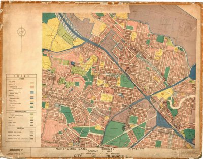
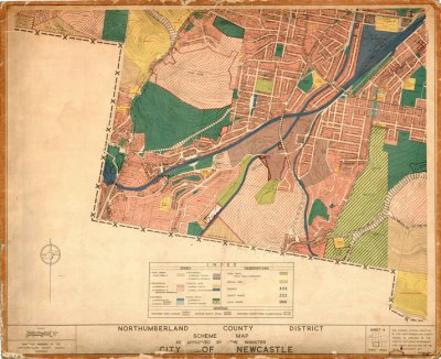
The following old maps in the University of Newcastle Cultural Collections shows the route of the Gully Line. (Note that rail corridors are coloured blue in these maps – don’t get fooled into thinking they are rivers!)
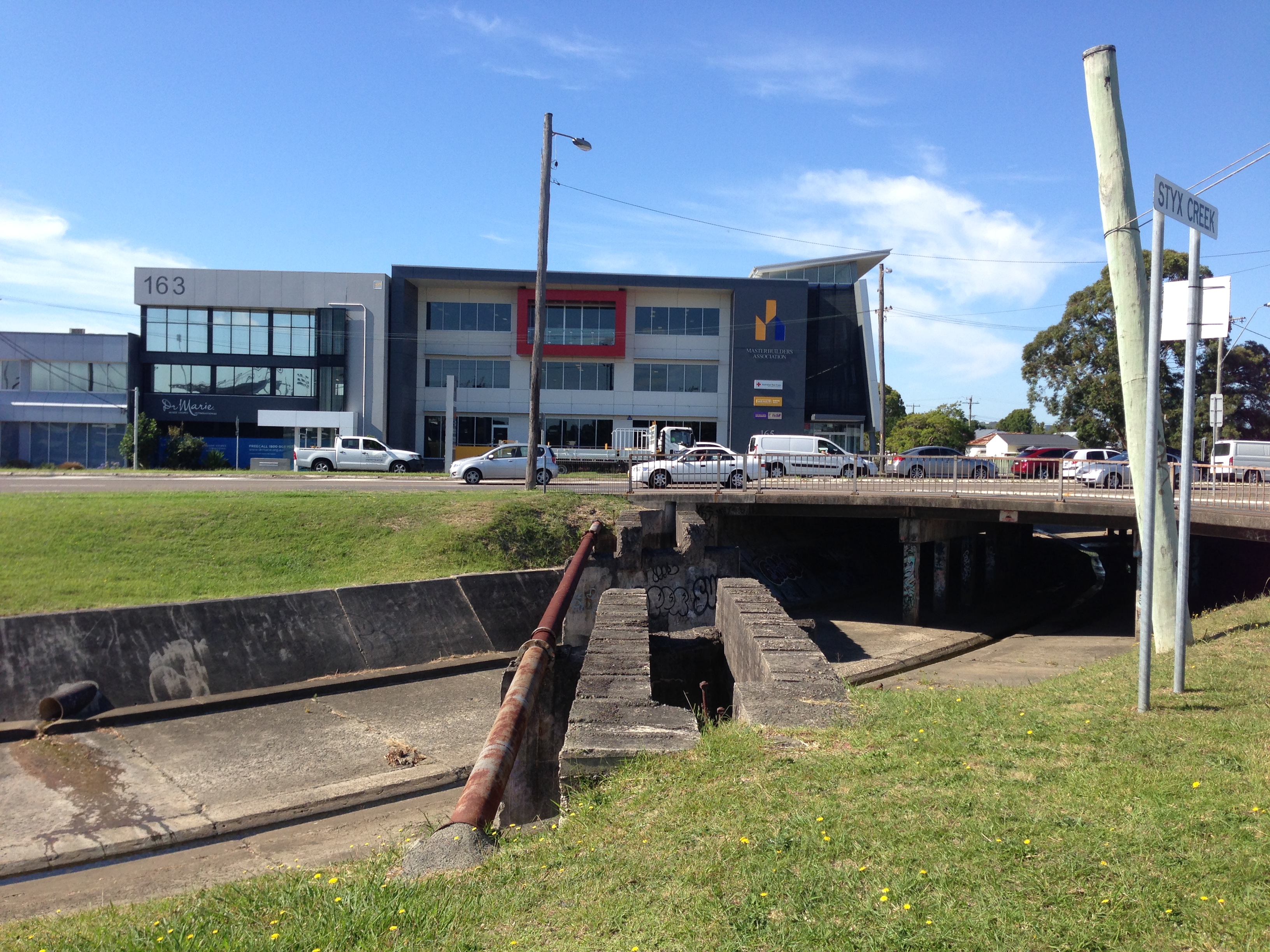
The remains of the bridge that carried the gully line rail across the stormwater drain in Broadmeadow.
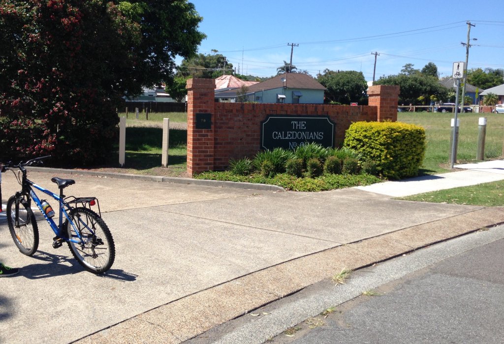
The South Waratah Colliery fell on hard financial times in 1895, and was taken over by the Caledonian Coal Company Limited, who then dropped the ‘South’ from the colliery name. This housing development on land previously occupied by the gully line is named after the new owners.

A slight crest in the road is the only remaining visible clue of where the gully line crossed St James Rd New Lambton

Looking north, through the underpass where the gully line passed under the main northern railway near St Pius X High School.

Similar to the St James Rd crossing, a slight crest in the road marks where the railway crossed Park Ave Kotara, just adjacent to the Dan Murphy’s store.

Looking north from Vista Pde Kotara, the present day cycle track veers away to the left of the path of the original rail line, which can be seen in the subtle dip of the landscape passing through the gap in the trees.
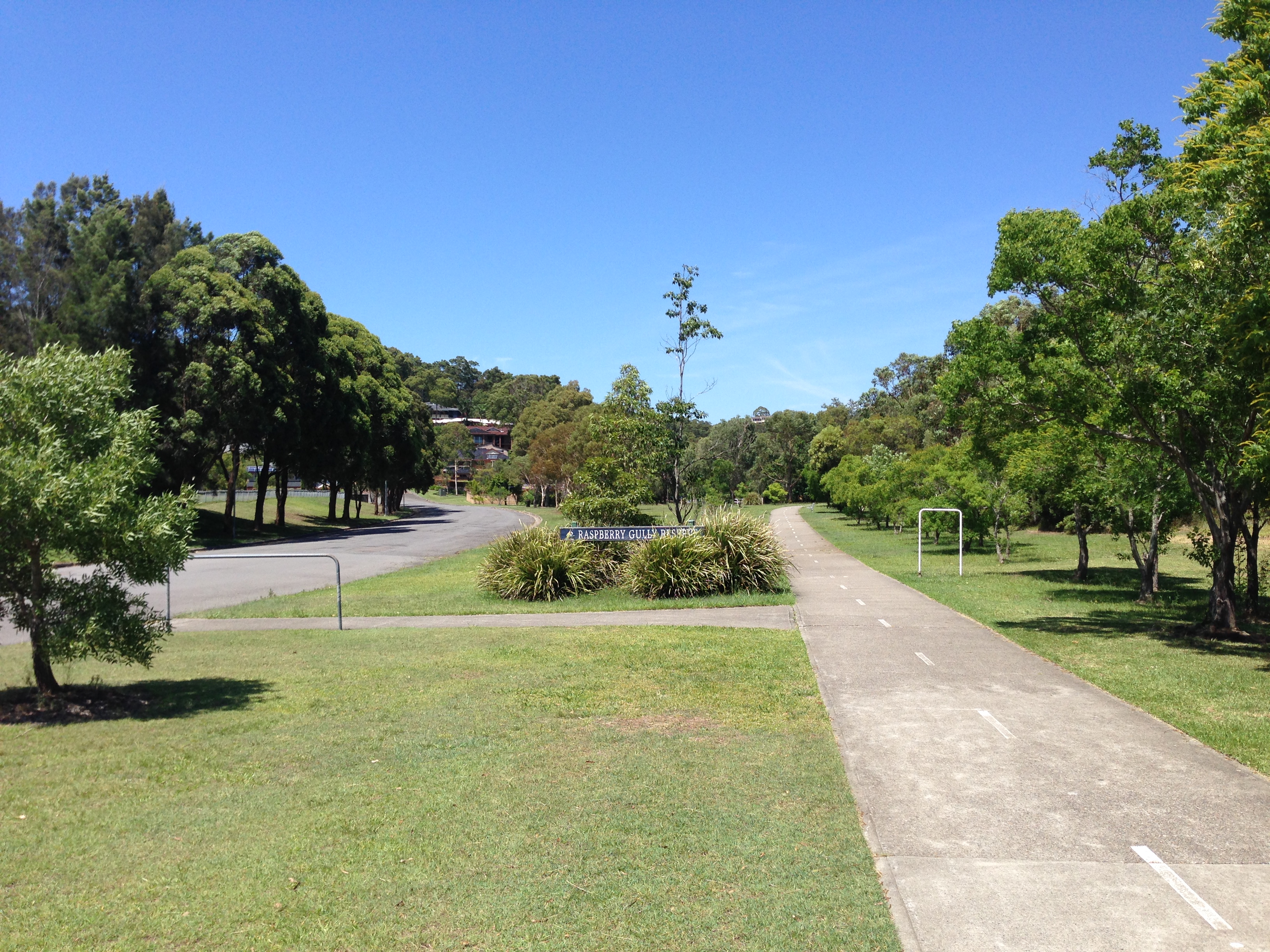
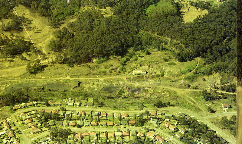
The South Waratah Colliery was situated in Raspberry Gully, just to the north of Charlestown, below the ridge that Charlestown Rd runs along. The Raspberry Gully name is preserved in the name of the reserve.

Somewhere here in this landscape the Waratah Colliery finished up production 53 years ago, in 1961. Nothing of the original colliery remains visible.

From Elton Close adjacent to Raspberry Gully, there is a set of stairs going up to Powell St Charlestown.

On Charlestown Rd, just near the turnoff into the shopping centre there are still standing four miners cottages built by the colliery to house strikebreakers in 1888.
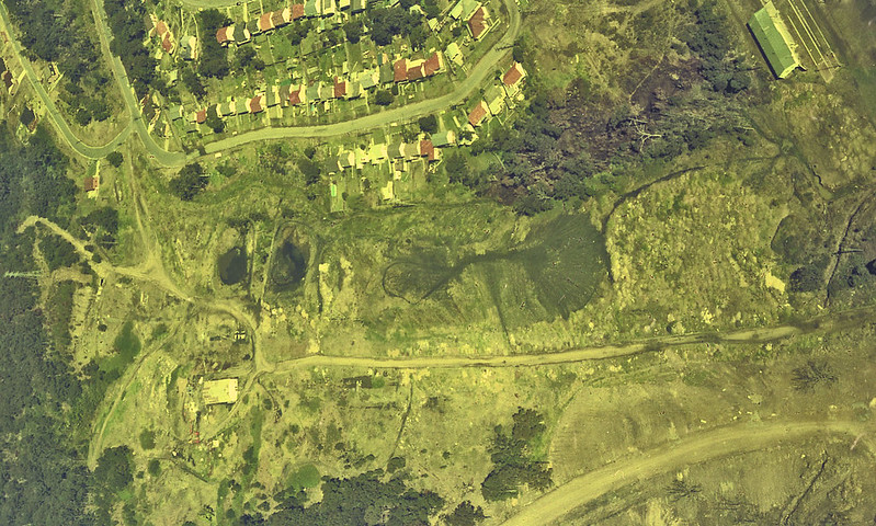
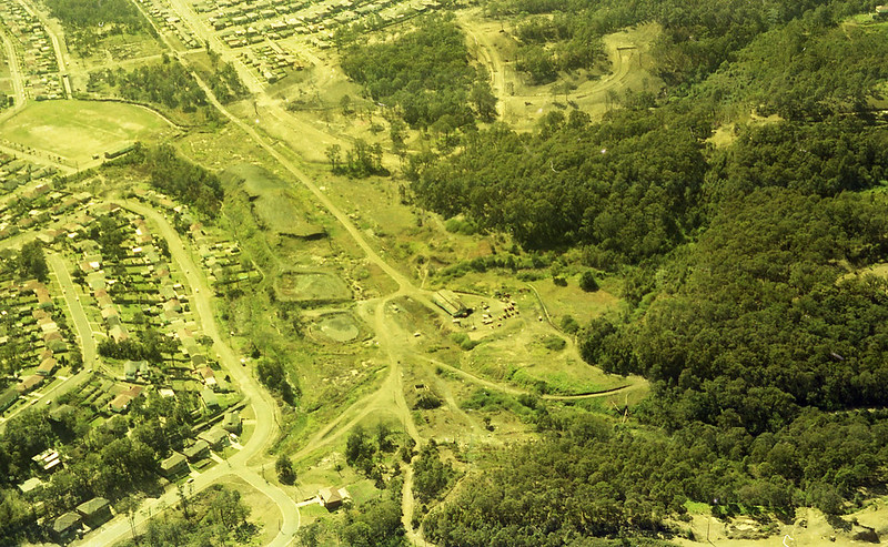
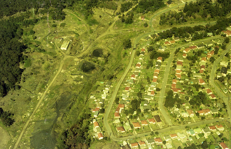
Update, May 2021. The University of Newcastle Living Histories website has a number of aerial photographs of the Raspberry Gully/South Waratah colliery site, in the Brian R Andrews collection. Click on the images below to view the original photo on the Living Histories site.
I grew up in Jellicoe Parade, New Lambton and the Gully LIne was directly across the stormwater drain from our house. I remember sitting on the front verandah as a toddler, watching the trains pass. The coal trains left a lot of soot in the air and my mother would always have to wipe the lines on the Hills hoist before hanging out the washing. My brother and I were also warned not to walk on the wooden rail supports between the rails. We learned later this was because the trains didn’t contain lavatory facilities.
Thanks for your recollections.
Lived in St James Rd when very young (3, 4 yo?) and have vague memories of train going past side of house and waving to driver. Must have been on corner of Mackie Avenue. Then moved to Kings Rd New Lambton, behind Adamstown station – lots more trains to wave at! Also remember Mum and other women heading off to the station master on washing days to complain about the soot being discharged from the engines as they powered up the rise to Kotara.
Reminded of all this when family asked me to write down some of early memories and experiences.
268 Charlestown Rd is also an old Cottage.
My maternal grandparents lived in Newton Street, Broadmeadow. I remember only too well the train going past the end of the street. If I was very well behaved I was even allowed to go down and watch them top up with water. My recollection is that the number of runs per week gradually reduced. I suspect it was daily but I particularly remember when it was twice per week and then the horror when it only ran once per week and the chances of seeing the train were reduced even further.
In 1963 I was the railway engineer who supervised the building of the bridge under the Main Northern Line so that Northcott Drive could be connected to Bridges Road.
The excavation of the embankment under running rail traffic was made all the more difficult because we found the remains of old timber bridge in the bank which obviously once carried the main line at this location. I’ve often wondered if this bridge once spanned the Gully Line (or was it the Caledonian Line?). Can you suggest what old line if any ran under the Main North at this location?
It was the Australasia Coal Company railway. See https://lachlanwetherall.com/then-and-now/maps-bridges-road for further information.
I lived in Cross Street New Lambton and could hear the old red rusty coloured engine that ran on this line, I thought it still made an infrequent trip up the line after 1961 as well
I lived in Charlestown 1966-1977. Raspberry Gully mine was abandoned yet largely still standing with buildings and railway line still intact. Also a huge coal chitter heap. We used to ride motorbikes down there. Main access was Sherburn Place which was only tar for a short distance, then degenerated into a windy old steep dirt rutted mine road. Also there was another old degraded dirt mine road coming off Charlestown Road about 100 metres from the Mattara Hotel where there were ruins of a house set back from the road. The whole mine site was covered in fine grey coal dust which seemed to suppress any vegetation. From the buildings parallel to the rail tracks past the chitter heap there was a lengthy flat stretch of old coal dust road that I remember I managed to squeeze an amazing 55 MPH out of my old BSA Bantam. Fond memories.
Thanks for your reminiscences.
My pleasure sharing memories. Besides the motorbikes we rode down in the pit, it was still possible to drive a car down and in a stupid moment I tried to launch my FC Holden over the old rail line and it ended up stuck on the rails, having to get several others to lift it off. Cheers