
 New Lambton Public School published a booklet in 1980 to celebrate their centenary. Although this book contains much useful information, it also contains a number of errors, which I document below. In doing so, I’m not intending to pass judgement on the authors of the booklet, who in 1980 did not have access to the many online resources available to me today. My intention here is simply to correct the record where I can.
The originally proposed site
The booklet quite correctly states that “The first site chosen was on ground owned by the New Lambton colliery.” This means that the site was south of Russell Rd, that road being the border between New Lambton and Lambton coal leases. The centenary booklet then states that the proposed site was “around the south-eastern section of St James Rd.” I have found no evidence to support that statement. Instead, we know that:
- In December 1875 Alexander Brown agreed to donate “a splendid site on the side of the hill near to the Wesleyan Church.”
- The Wesleyan Church was “situated at the upper part of the township“
- The Wesleyan Methodists began in New Lambton in 1868 “when they built a church on the corner of Evescourt road and Victoria street.”
I can only guess that the authors of the centenary booklet incorrectly assumed that the eventual site for New Lambton South Public School (opened 1944) was the originally proposed site for the New Lambton school.
Other corrections
- “New Lambton came into being in 1867”. The correct year is 1868.
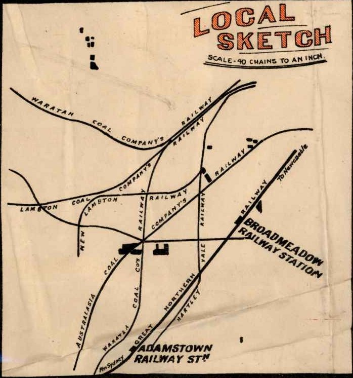
- The statement that the Lambton colliery railway “carried the coal to the wharves via ‘Betty Bun’s Crossing” is incorrect. Betty Bunn’s crossing was on the Waratah coal company’s railway.
- The statement that the New Lambton colliery railway went “across New Lambton Park to join the line from Lambton pit” is incorrect. The line actually curved to the right before the Lambton line, and was a separate line all the way in to its junction with the great northern railway.
- The statement that “New Lambton mine opened late in 1867” is somewhat misleading. In 1867 James and Alexander Brown opened up a new pit in their 280 acre “Dog and Rat” lease east of Lambton, and called it “The New Lambton Coal Pit”. The pit they sunk in the suburb of New Lambton wasn’t opened until 1868.
- The photo of the 1888 New Lambton Colliery Strike is somewhat misleading in that it doesn’t identify that this strike took place at the New Lambton C pit, which is actually in Adamstown.
- The booklet correctly states that “many smaller [coal mining] operations, often employing two or three men, were common around the turn of the century” and in the next sentence it lists some of the names of the pits. Two of the names mentioned were not small pits. Mosquito pit was part of Lambton colliery, and Dog and Rat pit was operated by the Brown’s mining company.
- There is a photo captioned “The first steam tram to Lambton 1891”. The photo might be from 1891, but its not the first steam tram, as the tram line opened in 1887.
- There is a photo captioned “1912 Aldermen New Lambton Council”. The list of names given does not correspond the alderman from that year. The list appears to match more closely with the alderman in 1914-1915. A number of the names are mis-spelled – “Gourd” should be “Goad”, “Jordon” should be “Jordan”
The map
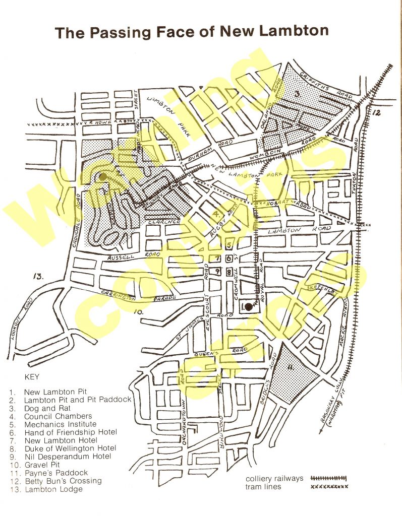
The map in the booklet contains a number of errors, some minor, and some nonsensical.
- “Rasberry Gully” is mis-spelled – it should be “Raspberry Gully”.
- The rail line to Raspberry Gully is marked as the “Waratah” pit, whereas it should be “South Waratah” pit.
- “Betty Bun’s” crossing is mis-spelled. It should be “Betty Bunn’s” crossing.
- The location marked for “Betty Bunn’s Crossing” at the intersection of Griffiths and Turton Roads is incorrect. The actual location was further to the west, at the intersection of Acacia St and Griffiths Rd. This was the point where the road between Lambton and Waratah townships crossed the Waratah Coal Company’s railway.
- Carrington Parade is shown as a continuous street, instead of split into two disconnected sections.
- The New Lambton colliery railway is shown as joining on to the Lambton colliery railway near Womboin Road. Competition between the collieries meant that sharing of rail lines was inconceivable. The New Lambton railway actually traversed the area now occupied by the sporting fields and Hunter stadium, and went all the way in to a junction on the great northern rail line.
- The map maker has assumed that the present day “Railway Rd” matches the alignment of the original Lambton colliery railway. This has resulted in a railway course with an impossible right angle bend. The railway actually ran in a fairly straight line slightly to the north of Railway Rd.
Hi. I read that you did research on New Lambton public school. I have found out that my great great great grandfather was a teacher there prior to 1887. I have a record of his teaching service but it doesn’t list the actual years. His name is Lawrence Rockliff. Any info you have of him or photos of the school then would be extremely appreciated.