Rankin Park Hospital

The peaceful lawns that surround Rankin Park hospital now are a stark contrast to the tumultuous time of war in which it was built.

In 1923 the Newcastle Hospital Board purchased “Lambton Lodge”, the former residence of Thomas Croudace, to use as a convalescent home. At the official opening in 1926, Archie Rankin, chair of the board, announced that a further 60 acres of land had been purchased with a view to expansion. The plans remained but a dream until the nightmare of a second war came to the world. The government intended to build a hospital on the site to cater for evacuees in the event of an emergency. On 5 December 1941 during a visit to Newcastle, the Minister for National Emergency Services said that the hospital was “still in the planning stage.”

Two days later Japan bombed Pearl Harbour and entered the war. There was now an urgent need for an inland emergency hospital, out of range of Japanese battleship guns. The government quickly allocated £20,000 to erect a temporary structure. However, with an eye to a post-war future, Rankin pressed for a permanent brick structure, promising that he could have a 100 bed hospital ready in just ten weeks.

“The government agreed. The Newcastle hospital authorities wasted no time. They gave the architects 36 hours to complete plans, and told them a start would be made on the foundations without plans if they were not ready.”

Newcastle Morning Herald, 14 Jun 1943

The brickwork commenced on 6 February 1942 less than two months after the Pearl Harbour attack, and true to the ambitious promise the building was erected in just ten weeks. Patients were being tended at the hospital by May 1942 although conditions were initially very primitive.

In 1943 it was announced that the facility would be used as a chest hospital for the treatment of tuberculosis. Now part of Hunter New England Health, the Rankin Park Centre provides rehabilitation services for patients recovering from injuries and stroke.

Rankin Park Unit of the Royal Newcastle Hospital, c1950. University of Newcastle, Living Histories.
Rankin Park Centre of Hunter New England Health, 2018.

The article above was first published in the July 2018 edition of The Local.

Additional Information

Some of the details for this article were obtained from “The Anataomy of an Artwork” (2002) by Cath Chegwidden, which is subtitled as “A fascinating history of the Rankin Park Aged Care and Rehabilitation Unit uncovered by the creation of artworks for its refurbishment.”

In particular, the information that patients were being tended in the hospital by May 1942 comes from page 8 of this book where the author states that

“my father Walter Chegwidden (now 85) told me that he had been a patient in Rankin Park when the miniature submarines entered Newcastle Harbour in May 1942.”

The Japanese submarine attack on Newcastle actually occurred on 8 June 1942, so either Walter Chegwidden was in the Rankin Park hospital in the month leading up to the submarine attack, or possibly it was June 1942 he was in the hospital and not May 1942. In any case the newspaper article from 1 May 1942 makes it clear that the hospital “could now, if an emergency arose, take between 100 and 150 cases.”

A picture of the new nurses’s home and a side view of the hospital was published in the Newcastle Morning Herald on 17 November 1945.  Comparing the photo of the hospital in the University of Newcastle Cultural Collections, in particular the car parked out the front, raises the intriguing possibility that the two photos were taken at the same time.

A side view of the Rankin Park hospital, November 1945.
Rankin Park Nurses’ Home, November 1945.

Newspaper articles

Article Date Event DateNotes
19 Oct 1922"The [Newcastle Hospital] board decided to complete the purchase of 'The Lodge' at New Lambton Heights for the purposes of a convalescent home from the Scottish-Australian Mining Company.
21 Dec 1922Renovations of the former home of Thomas Croudace are being considered by the Scottish Australian Mining Company, and it is noted that 'The Lodge' will not pass into the possession of the hospital for an other two years."
26 Apr 1926
24 Apr 1926
Official opening of the convalescent home, in the former residence of Thomas Croudace. "In addition to the original 24 acres, the board had secured sixty acres with a view to providing room for further institutions which at present were in dreamland. The convalescent home was the realisation of the first of their dreams."
16 Oct 1941"The Government Architect (Mr. Cobden Parkes) announced to-day that a new hospital would probably be built at New Lambton Heights near the Convalescent Home. This hospital is intended to be an emergency hospital to serve the needs of Newcastle district should the hospitals in the target area have to be evacuated during an emergency."
5 Dec 1941"The proposed Newcastle district emergency hospital at New Lambton Heights is 'still in the planning stage,' said the Minister for N.E.S. (Mr Heffron) today."
7 Jan 1942"Newcastle Hospital Board has laid a definite proposal before the Government for an emergency hospital at New Lambton Heights." The hospital would "deal with casualties which might occur in a raid." "A hospital of brick construction— which would cost only about 10 per cent, more than a wooden structure — is advocated by some. Such a hospital could be turned to good use after the war. Conversion of it to a T.B. clinic has been suggested."
23 Jan 1942"Claims for the establishment of an emergency hospital at Newcastle will be placed before the Minister for Health (Mr. Kelly) in Sydney to-day."
This article contains details of how the various hospitals would be used in the event of an emergency … "In anticipation of a state of emergency being declared, hospitals in the district have been instructed to admit only acute cases."
"It is considered that civil casualties could first be treated at [Newcastle] hospital and then transferred to the emergency hospital. Newcastle Hospital would be essentially a clearing station."
7 Feb 1942£20,000 allocation for start on New Lambton Hospital. "Workmen have already started on the job. They have prepared foundations and yesterday began placing bricks. The hospital will accommodate 200 patients. Mr. Rankin has given an assurance that 100 beds will be available within 10 weeks and 200 beds in another four weeks."
18 Feb 1942"The emergency hospital which is being built at New Lambton Heights has been designed for use as a T.B. hospital after the war."
12 Mar 1942"Bricks for the emergency hospital at New Lambton cannot be supplied before March 16 … available bricks had had to be diverted to protection work at Newcastle."
1 May 1942"The emergency hospital at New Lambton Heights, it was stated, was progressing particularly well and could now, if an emergency arose, take between 100 and 150 cases."
1 Mar 1943The emergency hospital nearing completion will be used as a chest hospital for the treatment of tuberculosis.
14 Jun 1943Chest hospital not expected to be open for several months - delay in the delivery of material and equipment has held up the completion of the hospital. This article contains details about Archie Rankin's involvement in the very tight construction timeframe.
17 Nov 1945Photos of the new nurses' quarters at the New Lambton Chest Hospital, and a side view of the hospital.
24 Mar 1947"Representatives of the Newcastle Hospital Board, the Red Cross Society and the Hospitals Commission met in Sydney today to discuss the opening of the New Lambton Chest Hospital. The Red Cross Society has offered to provide sufficient staff to run the hospital."

New Lambton Colliery

“In the depths of the bush, about half a mile to the south of the rising and flourishing township of Lambton, there was celebrated, on Thursday last, an event of no ordinary interest and importance.”

Thus began a Newcastle Chronicle report on the ‘turning of the first sod’ of the New Lambton colliery on 25 June 1868.

James and Alexander Brown were mining coal from the ‘Old Dog and Rat’ pit in East Lambton when they had a lucky break in 1868. On learning that the owners of Lambton colliery had failed to make payments on a mining lease, the Browns quickly stepped in and bought the mineral rights for 265 acres in the area we now know as New Lambton.

They immediately investigated the potential of their acquisition by commencing a trial shaft in April 1868. In June, at a depth of 100 feet, a good payable seam of coal was found and the Browns committed to developing a colliery at a cost of £10,000.

To inaugurate their new venture the Browns invited their employees and local dignitaries to a ceremony at the site on 25 June 1868. Two barrels of ale which had previously been conveyed to the ground, were at once tapped, speeches made, and the assembled company called upon to drink “Success to the New Lambton Colliery”.

Success came quickly, a new working shaft 16 feet in diameter was sunk, an engine house erected and a railway constructed to convey coal to the port. The colliery attracted miners and their families, and a town began to grow. Just a year later New Lambton was described as “going ahead, and buildings of all descriptions are multiplying fast.”

By 1884 the payable coal was exhausted, and the Brown’s moved on to establish other mines. The pit closed, but the town endured. The Chronicle was correct in asserting that the event celebrated 150 years ago was of no ordinary importance, for it marked the birth of New Lambton.

Major T S Parrott’s 1893 map of Newcastle showing the railway and a shaft of the New Lambton colliery. National Library of Australia.

Google Earth, showing the New Lambton Colliery mining lease, railway line, and a shaft located near present day Oxford St.


The article above was first published in the June 2018 edition of the Lambton & New Lambton Local.

Additional Information

In working out the history of the New Lambton colliery I have used the following sources:

  1. Contemporary newspaper articles retrieved from Trove.
  2. “The Coal Mines of Newcastle NSW”, George H Kingswell, 1890.
  3. Map of Waratah Coal Company blocks, 1873. National Library of Australia.
  4. T S Parrott’s Map of the country around Newcastle, 1893. National Library of Australia.
  5. Plan of the Hartley Vale Railway, 1867. State Library of NSW.
  6. The Hartley Vale Railway Colliery act of 23 Dec 1867
  7. “Coal, Railways and Mines, Vol 1”, Brian Robert Andrews, 2004. (Although much of Andrew’s information is taken from the above sources.)

Trying to work out the history of the New Lambton Colliery, and the mines of J and A Brown in Newcastle is a tricky matter for a variety of reasons.

  • The newspaper articles are sparse and often very cursory, and can sometimes contain errors.
  • The term “pit” is ambiguous – it could mean
    • a specific shaft
    • a collection of mine buildings at a particular location
    • a mining lease
    • a mining company
  • Suburb names in a mine name can be misleading and bear no relation to geography. The classic example of this is the “East Lambton Colliery“, which was located in New Lambton, and operated by the Waratah Coal Company!

Bearing in mind these difficulties, here’s my summary of the Brown’s  mining leases and the history of New Lambton colliery.

Colour Notes
White Development of this 310 acre lease commenced in 1863 as the Hartley Vale Colliery. The colliery was ready for production at the end of 1864, but was a commercial failure. In a c. 1873 Waratah Coal Company map this area is marked as “Brown’s Colliery” and “Brown’s shaft”.[ Brian Andrews on page 36 of his book “Coal, Railway and Mines, Vol. 1” indicates that this coal lease began development in 1861, but I cannot find any corroborating evidence for this. A report on Alexander Brown’s death in 1877 suggests that the Browns only acquired the land at Hartley Vale after they had sold off their Minmi colliery, which occurred in early 1863.]
Pink
This 54 acre block was considered part of the Hartley Vale Colliery. The land was sold to Thomas Adam in 1869 and became the township of Adamstown.
Blue This 280 acre lease was obtained by J&A Brown in 1862. Two pits  (marked as A and B pit on the 1867 Hartley Vale railway map) were commenced to the north of the Lambton colliery railway in 1866. The B Pit later became known as the “Dog and Rat Pit.” These workings were connected to the New Lambton/Hartley Vale railway via a tunnel underneath the Lambton railway. The reason for the tunnel is described in the Empire newspaper of 2 September 1867.

The Messrs. Brown have coal bearing land between Lambton and Waratah, which they cannot work without passing from the Lambton railway, or going under it to their own Hartley Vale railway. Having waited two years to get an Act passed to amend the Amended Railway Act without success, they have apparently taken the law coach into their own hands, and will drive it, not through the Act, but under it : so they have commenced operations by driving a dip tunnel from their own land, intersecting the Lambton railway at an angle of forty-five degrees, but so much below it as to leave it perfectly secure, even to the most fastidious.

In 1867 the “New Lambton Coal Pit” was opened on the 280 acre lease, to the south of the Lambton colliery railway, with a short curved branch line off the New Lambton railway. This pit later became known as New Lambton A Pit when the new ‘B’ workings were opened up in the 265 acre lease in 1868. (See below.) Some time around 1883 the New Lambton A Pit was renamed New Duckenfield Colliery.

Green This 265 acre lease obtained by Stephen Foyle (on behalf of the Browns) in late 1867 when Morehead and Young failed to pay rent on lease. A trial pit was finished in June 1868 and a celebration held to inaugurate the “New Lambton Second Coal Working”, the first New Lambton coal working being the 280 acre lease in East Lambton. A working pit was commenced soon after. Somewhat confusingly, this New Lambton second coal working also became known as “the B or New Lambton Pit” (Kingswell)

Kingswell gives two contradictory dates as to when this pit ceased. On page 46 he states that the “B or New Lambton Pit” was “worked until the beginning of 1888”, and in the very next paragraph state that in 1884 “the old B Pit (was) finally abandoned.” (Although possibly this second reference is to the Old Dog and Rat pit in East Lambton?)

Orange/Red This 640 acre area consisting of two 320 acre leases was obtained by J&A Brown and Stephen Foyle in March 1867. The December 1867 Hartley Vale Railway act shows that the Brown’s intended to build a railway to this lease, but it was not completed at this time. After the New Lambton second workings began to wind down in 1884, the New Lambton ‘C’ Pit was commenced in this area in 1884, and the railway finally completed in March 1884.

The mining leases of J and A Brown.

The mining leases of J and A Brown in Newcastle, overlaid onto 1873 map.

1867 Hartley Vale Railway map showing location of New Lambton Colliery pits.

1944 aerial photograph that shows the remnants of the New Lambton railway traversing the park.

Path of rail line to New Lambton B pit marked in red, and the short branch line to the New Lambton A pit marked in yellow.

Kingswell’s 1225 acres

On page 45 of “The Coal Mines of Newcastle NSW”, Kingswell states that the New Lambton Estate consists of 1225 acres.

In the year 1867 Messrs. J. and A. Brown commenced to work coal from the New Lambton Estate, which at present is the freehold property of Messrs. George R. Dibbbs, and Alexander Brown, M’s. P. It consists of 1225 acres, and is bounded on the north and east by the Commonage, on the south by the Waratah Coal Company’s land, while the estate of the Scottish Australian Mining Company forms the western boundary. Prior to opening a mine the firm obtained a mineral lease of some 280 acres from the Government, and on this block, which lies to the north of the present estate, the now celebrated Dog and Rat, or A Pit, was sunk.

Where was this 1225 acres? It is difficult to be certain, but given that in the next sentence he refers to the 280 lease as being “prior” and to the north of the “present estate”, then it is reasonably clear that the 280 acre lease (blue) is not included in the 1225 acres.

Thus adding the 310 acres (white), 265 acres (green) and the 640 acres (orange/red), comes to a total 1215 acres, which is very close to the figure of 1225 acres that Kingswell state. The discrepancy of 10 acres could be accounted for in two ways. It is possibly simply an adding up error, or possibly because the 265 acre lease on the maps is marked as “ex rds”, and that these excluded roads account for the missing 10 acres.

Newspaper articles

Article Date Event DateNotes
3 Dec 1867First mention of New Lambton colliery in the newspapers. The article is reporting on the opening of a section of the Hartley Vale Railway, that leads to a new pit a pit "about half a mile ... from the Lambton Colliery, and which has been denominated by the Messrs. Brown 'The New Lambton Coal Pit.' "
If the distance of half mile is correct then this is almost certainly referring to a pit in the 280 acre lease in East Lambton. The article goes on to state that "The line further leads to a pit on the other side of the South [sic] Australian Company's Railway, underneath which a tunnel has been made." This is possibly referring to a connection to the Dog and Rat Pit which was to the north of the Lambton colliery railway.
4 Jan 1868James and Alexander Brown obtain the mineral lease for what would become the New Lambton mine, after Messrs. Morehead and Young of the Scottish Australian Mining Company indavertently fail to keep up payments on the mineral lease.
27 Jun 1868
25 Jun 1868
'Turning the first sod' of the New Lambton Colliery.
30 Jun 1868"The tunnel now in operation [the 280 acre east Lambton lease] will I believe give remunerative employment to about sixty miners, and I have no doubt, a profitable return to the proprietors for capital invested therein, until the new pit [265 acre lease in New Lambton] is in full working order."
4 Jul 1868"The new railway works at the New Lambton Colliery are being pushed forward as fast as practicably, and are I believe progressing satisfactorily."
4 Jul 1868Advertising for tenders for the sinking of the new working pit, and for earthworks in the extension of the New Lambton railway.
18 Jul 1868"The new line of railway at the new Lambton colliery is making considerable headway but the sinking of the new working pit has been considerably delayed in consequence, I believe, of the difficulties experienced in getting a boiler across a swamp separating the new pit from the end of the present railway."
5 Sep 1868"The extension of the New Lambton railway, is, I believe, progressing satisfactorily, and will, it is expected, in a short time, be so far advanced towards completion as to enable the proprietors to convey direct, any materials that may be required at their new pit, which is now down about seventy feet. It is expected that the coal in this shaft will be found at a depth of about 120 feet."
31 Oct 1868The Brown's New Lambton colliery "line of railway will be shortly completed."
29 Jul 1869"New Lambton is still going a-head, and buildings of all descriptions are multiplying fast. I am glad to see that those enterprising and really spirited men, the Messrs. J. and A. Brown, have commenced making a new line of railway to another new pit."
3 Mar 1877"Plans and specifications have been prepared for a bridge to cross the New Lambton Railway, and tenders will be called for the erection at once."
This was for a bridge on Lambton Rd (where Royal Place is now) to go over the New Lambton railway.
25 Aug 1883"The proprietors of the New Lambton Colliery are sinking a new shaft on their estate some mile and a-half from the present pit." This was the New Lambton C pit, which was located in the present day suburb of Adamstown.
22 Mar 1884"The railway to the new pit [C Pit] on the New Lambton Company's estate has been completed throughout in a very workmanlike manner by the contractor, Mr. Chas. Turner, and a large staff of workmen. The line is about two and a-quarter miles in length from its junction with New Lambton railway to the pit mouth."
1 Aug 1890New Lambton council prepares "specifications for the work of pulling down the New Lambton Railway Bridge, on the main road, and filling up the road."
6 Aug 1890Tenders called for "filling in roadway over New Lambton railway at main road bridge."
19 Jun 1925"The old shaft in Cromwell-street, New Lambton, the covering of which collapsed last week, has not yet been filled. The Mayor informed the council meeting that he had arranged to tip into it eight or 10 truck loads of rubble from the quarry, and New Lambton Coal Co, had agreed to complete the filling."

Oh look, a shiny book

Oh look, a shiny book. And my name is on the cover.

Julie Keating has continued her series of books focussing on Newcastle suburbs in the 19th and early 20th century. For the latest book on New Lambton, Julie invited me to contribute some of my blog articles on various aspects of New Lambton history.

The book is $25 and can be purchased from New Lambton Post Office, MacLeans bookshop in Beaumont Street Hamilton, and the the Marketown Newsagency in Newcastle West.

Dog and Rat Colliery

The origin of the name may be uncertain and the precise location unknown, but the “Dog and Rat” pit was once a celebrated colliery of the East Lambton area. In 1862 James and Alexander Brown obtained a 280 acre mining lease south of Waratah, and in 1866 opened the unremarkably named A Pit and B Pit. By 1871 however, the southern pit was known as the “Old Dog and Rat”.

There have been several explanations offered for the name, that it is rhyming slang for “Griffiths’ Flat” or because miners took their dogs underground to hunt rats. The likely explanation is that it derives from the sport of rat coursing. The earliest report on the origin of the name notes that

“although the area was a dense bush, with swampy ground on either side, quite a number of men could obtain a day’s sport with their dogs hunting the rats.”

The name of the pit also attached to the road leading to it. What is now Young Rd was previously known as Dog and Rat Rd.

The pit ceased operation in 1884, although there were a few later attempts to extract remnant coal. It is last mentioned in the Department of Mines annual report of 1893, where

“David Hughes gave notice that he had ceased all work at the Old Dog and Rat, and filled up all shafts.”

The colliery was gone, but the name hung around. In 1925 the East Lambton Progress Association wrote to the Council requesting that the name “Dog and Rat” be discouraged. The Mayor responded that as it was not an official name, there was nothing to be altered.

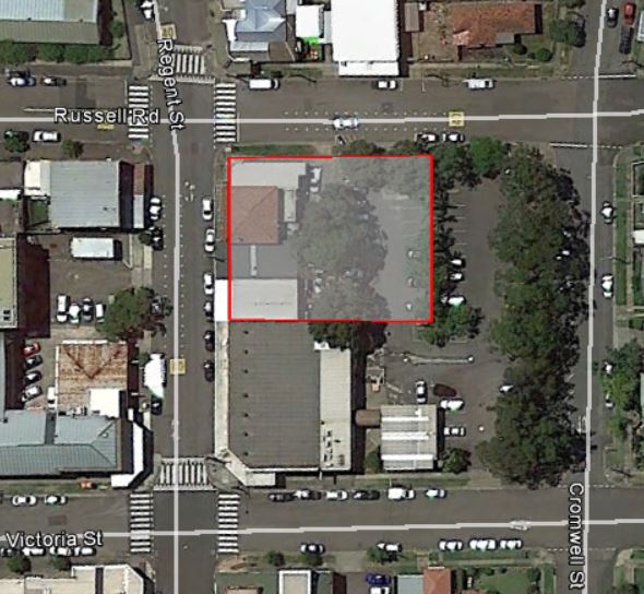
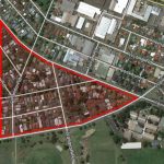
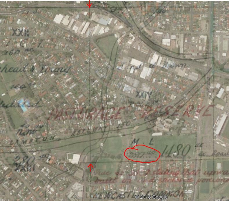
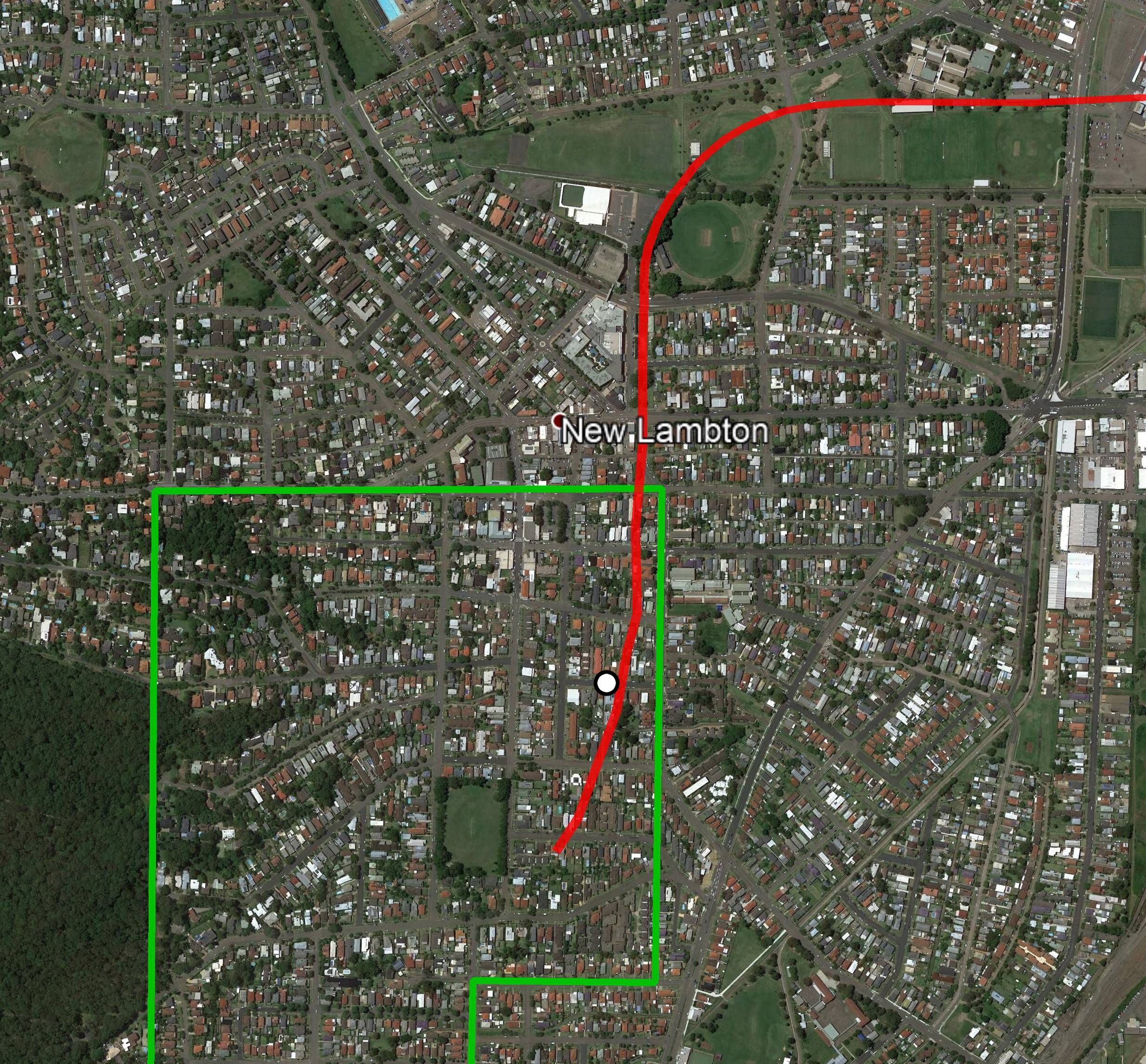
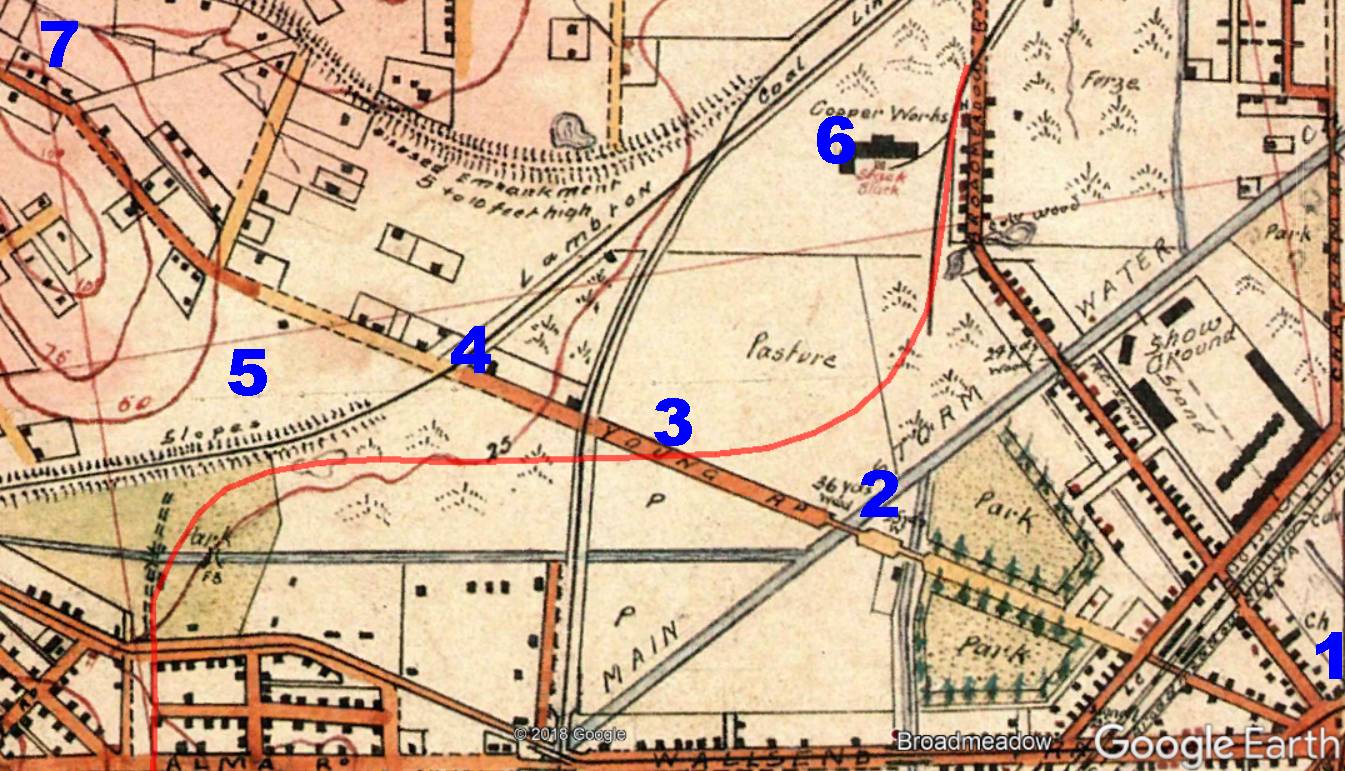
Where was the pit? Three pieces of information give us a clue. An 1871 report indicates that it was within the Lambton Municipality, which places it north of Womboin Rd. An 1874 report states that it was south of Lambton to Hamilton road. Finally, the western boundary of the Brown’s lease means it was located somewhere in the triangular area below.

The Dog and Rat pit was located somewhere in this triangular area of East Lambton. Google Earth.

Update, January 2019: In the originally published article I stated that the pit was located south of Young Rd. After more research, I am of the opinion that it was located just to the north of the present day Young Rd. See below for further details.

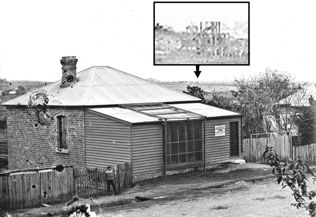
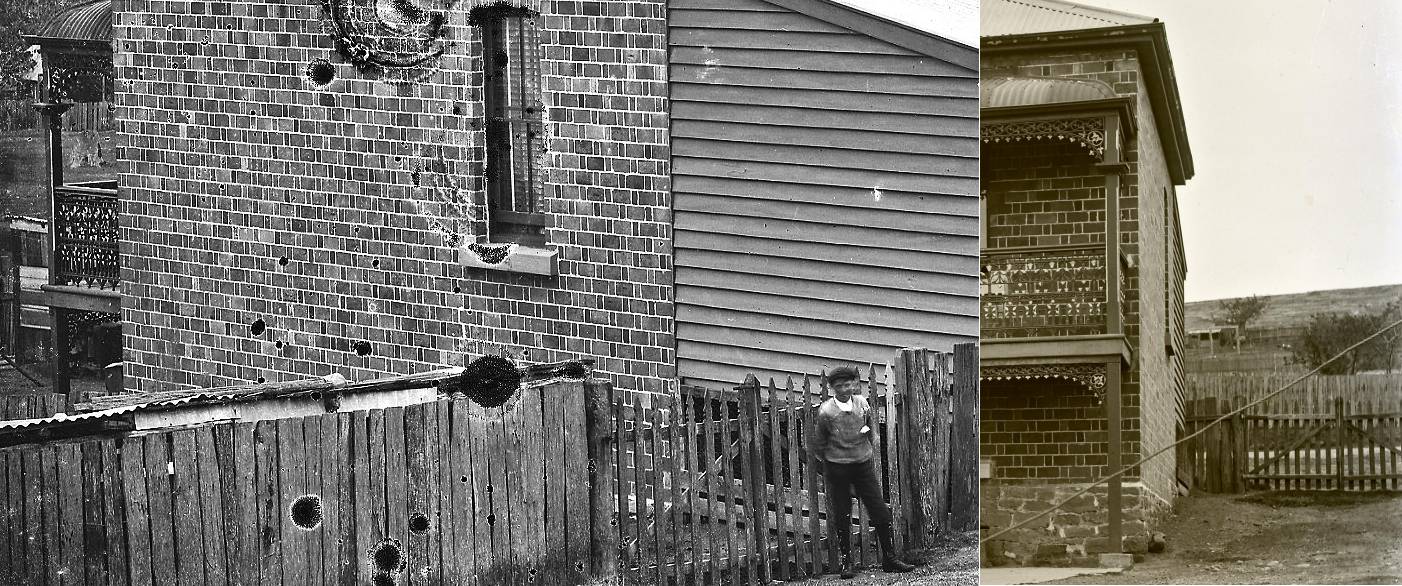
Ralph Snowball’s studio at 19 Clarence Rd, New Lambton. The colliery headframe barely visible on the horizon is probably the Dog and Rat pit. University of Newcastle, Cultural Collections.


The article above was first published in the May 2018 edition of the Lambton & New Lambton Local.

Location of the pit

Three pieces of information constrain the location of the “Old Dog and Rat” pit to within a triangular area of East Lambton.

1. Womboin Road

A public meeting was held in Lambton on 14 July 1871

“for the purpose of bringing forward from amongst them the most fit and proper persons to be nominated as candidates for the office of aldermen in their newly-appointed municipality.”

The electoral status of one of the participants in the meeting was questioned when …

“Mr. Hindmarsh objected to Mr. Hardy asking any questions, he not being an elector. Mr. Hardy said that he resided within the proclaimed boundary, viz , at the Old Dog and Rat Pit, of the Messrs. Brown, inside of the Lambton railway. The Chairman ruled that he (Mr. Hardy) was an elector.”

A map from a 1906 real estate poster shows that the municipal boundary ran along the Lambton colliery railway adjacent to present day Womboin Rd. Also the phrase “inside of the Lambton railway” suggests that the Dog and Rat pit was to the north of the curved section of rail line.

Portion of 1906 real estate poster, showing boundary of Lambton Municipal Council. University of Newcastle, Cultural Collections.

2. Young Road

In the 1870s when there was a push to get a main road built from Newcastle to Wallsend, there was much dispute about the route that it should take. There were two competing proposals – a southern route that passed through New Lambton (Lambton Rd) and a more direct northern route that approximately followed the line of Young Rd.  On 6 May 1874 Thomas Croudace, an advocate for the southern route, wrote a letter to the editor comparing and contrasting the two proposals. Compare his description of the northern road with the annotated map below.

“The route upon leaving Hamilton1 proceeds north-westerly over the BroadMeadow Swamp2, across the New Lambton3 and Lambton railways4, between the old Dog and Rat Pit5, and New Lambton Smelting Works6, to the ridge whereon old Peacock lives7, and thence to the dividing line of Lambton and Grovestown townships.”

Thomas Croudace’s description of the proposed northern route of the main road.

The “New Lambton Smelting Works” was located in present day Broadmeadow, so therefore the Dog and Rat Pit must have been to the south of proposed northern route.

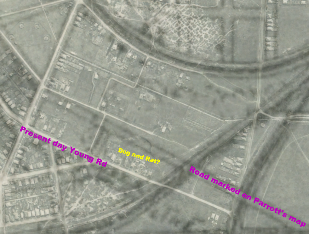
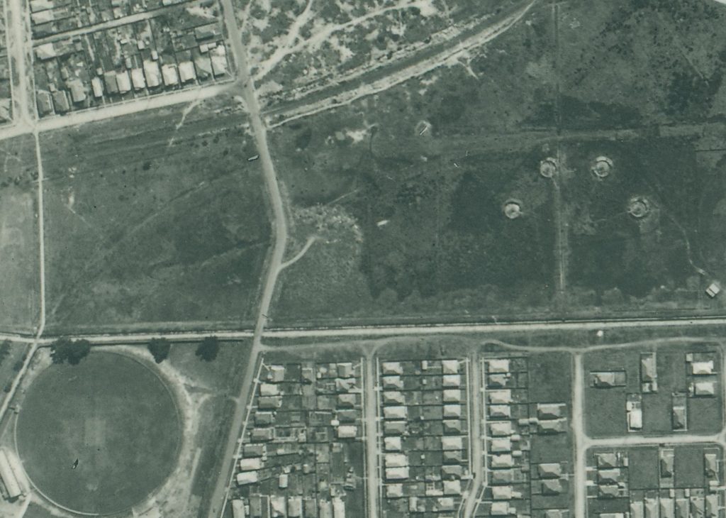
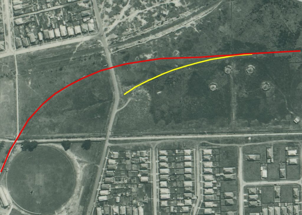
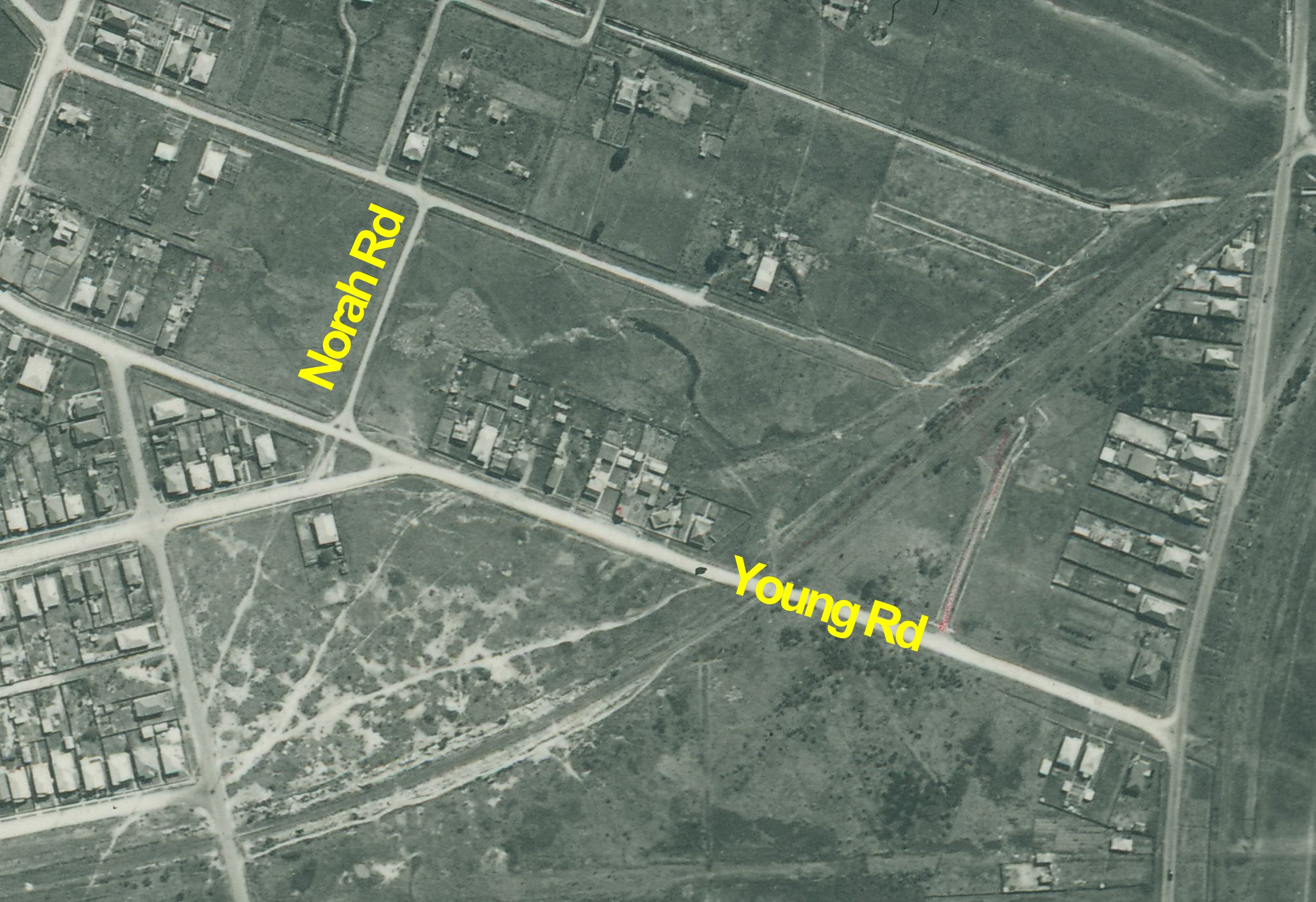
I originally believed that the northern route that Thomas Croudace described was identical to the line of present day Young Rd, but I no longer think so. A 1944 aerial photograph of the site shows not much evidence of a former pit head to the south of Young Rd, but reveals a more likely site to the north of Young Rd, near Norah Rd.

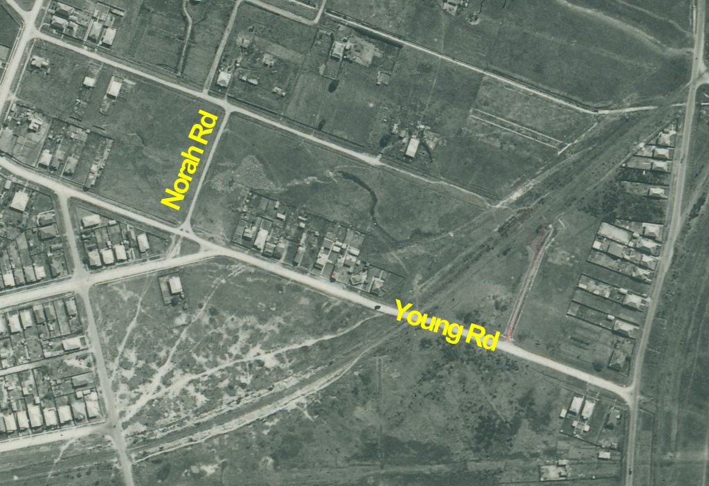
A 1944 aerial photograph of the site of the Dog and Rat Pit.

There is suggestive evidence that the proposed line of road described by Croudace in 1874 is not the exactly the same as Young Rd. In 1876, two years after the road had been gazetted in May 1874 it appears that there was still confusion about where the road would run. In a Lambton Council meeting on 22 Feb 1876 it was moved

“that a letter be sent to the District Surveyor, asking him to point out the line of road from the Lambton township to the Lambton Company’s railway crossing  … as there seemed to be some doubt as to where the road would cross.”

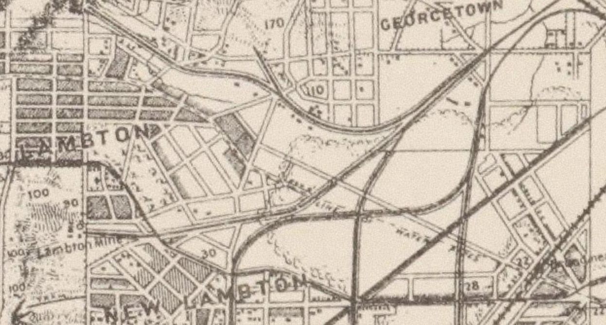
Also in 1893, Major Parrott’s map of the area shows the road crossing the Broadmeadow swamp from Lambton to Hamilton at a slightly different angle and just to the north of the present day Young Rd. (Note that on Parrott’s map, the dashed line marked as “Water Pipes” is the line the road eventually took.)

1893 Parrott map showing Lambton to Hamilton road.

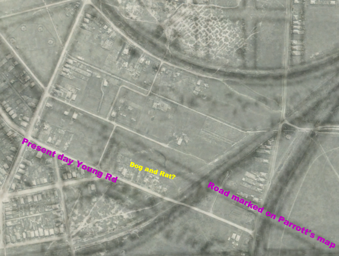
Overlaying the Parrott map and the 1944 aerial photograph into Google Earth shows that the possible site of the Dog and Rat pit near the intersection of Young and Norah Rds is to the south of the road marked on Parrot’s map.

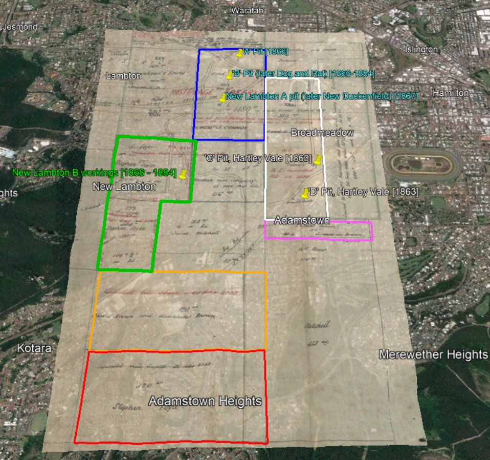
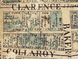
3. Brown’s mineral lease

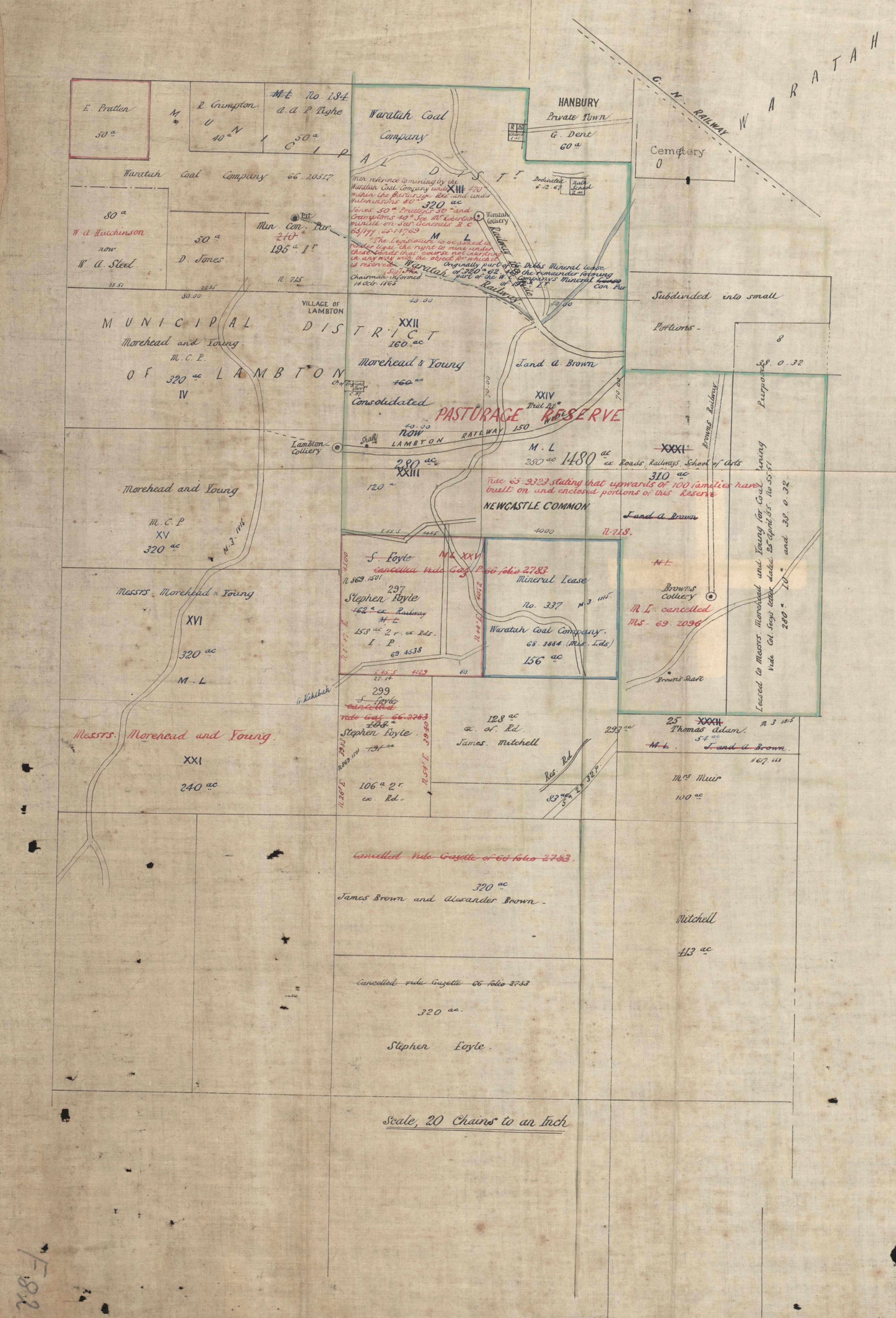
An 1873 map of Waratah Coal Company leases, shows the 280 acre lease of J and A Brown.

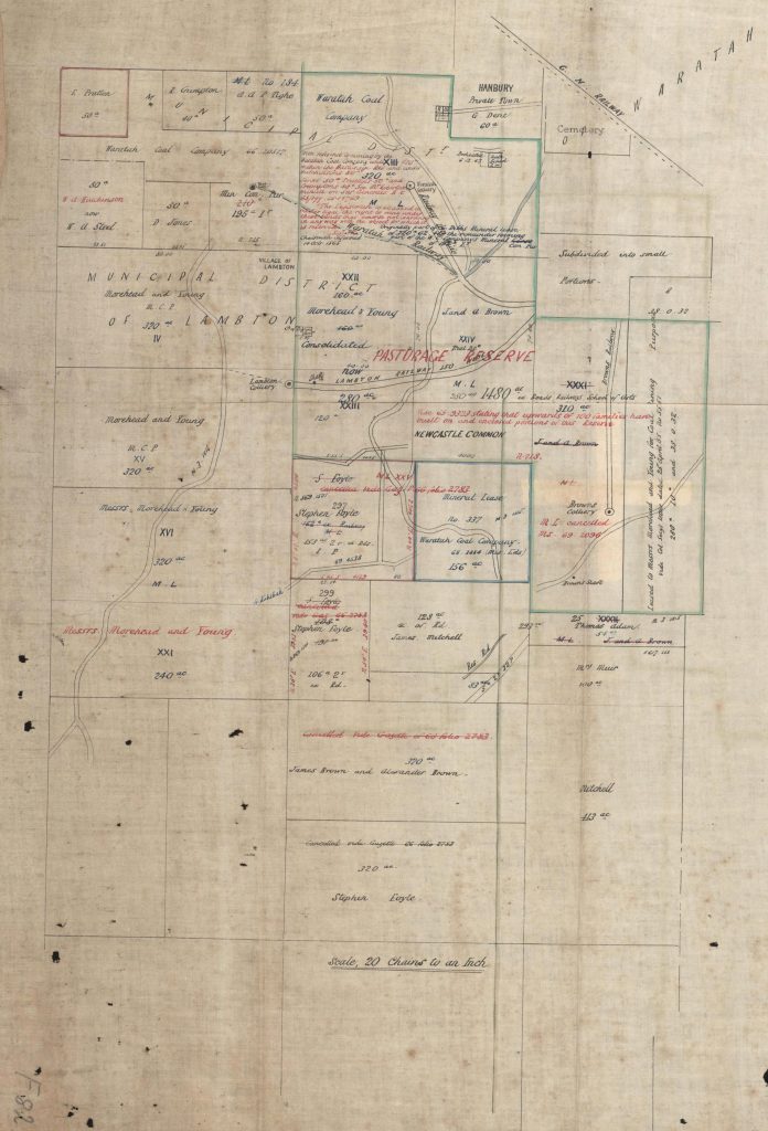
Waratah Coal Company blocks, 1873. National Library of Australia. MAP F 82.

When overlaid into Google Earth, this establishes the western boundary of possible locations for the Dog and Rat Pit.

J and A Brown’s 280 acre lease.
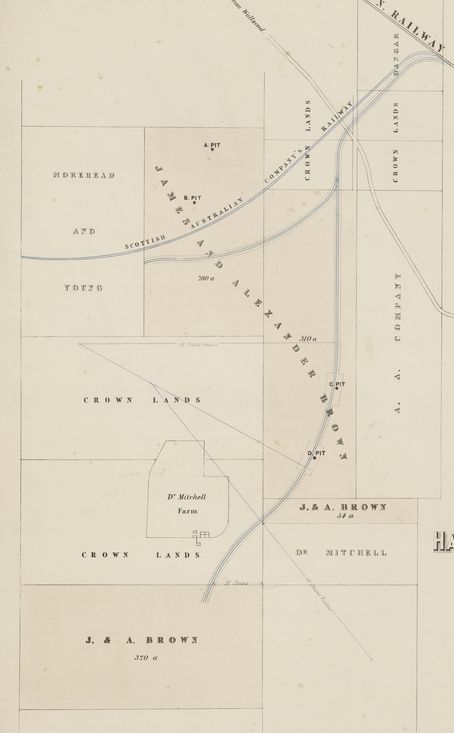
The rail tunnel

One of the difficulties that James and Alexander Brown faced with their 280 acre mining lease was that the Scottish Australian Mining company’s railway to Lambton colliery (shown in red in the map below) divided the Brown’s lease into two portions. This presented the problem of how to get coal extracted from the B pit to the Brown’s New Lambton railway (shown in blue in the map below.)

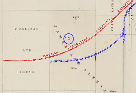
Rail lines through J & A Brown’s 280 acre lease.

There was fierce competition and intransigent lack of co-operation between the collieries at that time as reported in the Empire newspaper of 2 September 1867.

The Waratah and Lambton collieries have been for several years accomplished facts, each colliery having its own separate line of railway connecting the colliery with the Great Northern Railway, and in the instance of Waratah with its own port of shipment. When these railway Acts were passed, we thought that great care was exercised to make them public railways instead of of private ones, and that points and crossings should or could, be laid into them at any place, a neighbouring coal proprietor might require them, whereby to take his coals to Newcastle — in fact, to market in New South Wales. But no, some technicality sufficiently feasible, stands up, and is apparently powerful enough to prevent any interference with existing lines of railway, public or private, with out another specific Act of Parliament.

The Scottish Australian Mining Company would not allow a competitors railway to crossed their own line, so the Browns resorted to an ingenious solution.

The Messrs. Brown have coal bearing land between Lambton and Waratah, which they cannot work without passing from the Lambton railway, or going under it to their own Hartley Vale railway. Having waited two years to get an Act passed to amend the Amended Railway Act with out success, they have apparently taken the law coach into their own hands, and will drive it, not through the Act, but under it : so they have commenced operations by driving a dip tunnel from their own land, intersecting the Lambton railway at an angle of forty-five degrees, but so much below it as to leave it perfectly secure, even to the most fastidious.

This rail tunnel is also referred to in another article in Empire from 3 December 1867, reporting on the opening of a section of the New Lambton/Hartley Vale colliery railway.

The line further leads to a pit on the other side of the South Australian Company’s Railway, underneath which a tunnel has been made.

The location of Brown’s rail tunnel under the Lambton colliery line is not marked on any maps, but given the location of the Dog and Rat Pit, the tunnel was probably somewhere in the vicinity of the modern day intersection of Young and Womboin Roads.
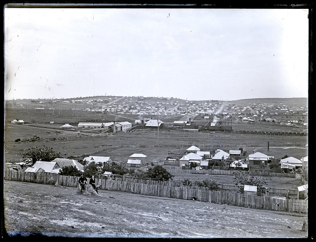
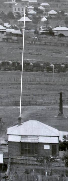
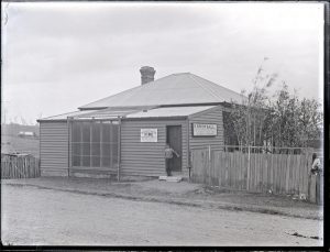
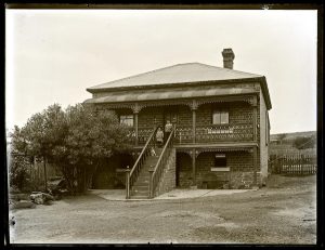
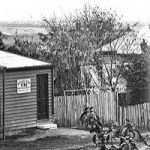
The Snowball photo

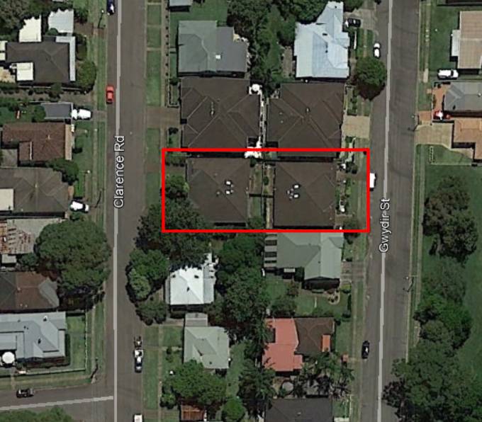
The undated Ralph Snowball photo is of his house and studio at 19 Clarence Rd New Lambton, looking towards the north east. On the horizon, a colliery head frame (1) can be seen between two identifiable features – the Waratah Benevolent Asylum (2) on the left, and the chimney of the New Lambton Copper Smelting Works (3) on the right.

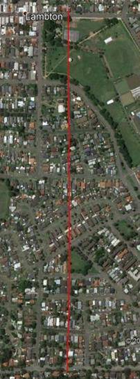
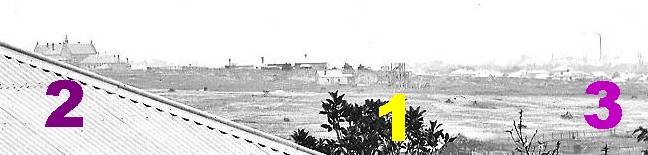
Replicating those angles as lines in Google Earth, we see that the middle line passes directly over the triangular area in East Lambton where we know the Dog and Rat pit was located. So although we can’t know with 100% certainty, it is highly probable that the colliery head frame in the photo is that of the old Dog and Rat pit.

Annual Mining Reports

The NSW Department of Planning and Environment, Resources and Geoscience section, has an online archive of historical mining documents in their Digital Imaging Geological System (DIGS) . A number of the annual reports in the archive include references to the Dog and Rat pit.

Year Notes
1879 Dog’s Rat.-Two miners getting house coal on their own account on the New Lambton Estate. No cause of complaint.
1882 Dog and Rat, Waratah Commonage.  August 11.-Messrs. D. Hughes, B. Tonks, and J. Ruttley, of Waratah, gave notice of having sunk a shaft to mine for coal on what is known as the Dog and Rat Estate, leased by Messrs. J. & A. Brown, Waratah Commonage.
1883 Page 129. Dog and Rat pit – 3 men above ground, 19 underground. Tonnage included with New Lambton and New Duckenfield.
1884 Page 127. Dog and Rat pit – 3 men above ground, 10 underground. Tonnage included with New Lambton and New Duckenfield.

Page 140. Dog and Rat. -There are about ten men employed in this mine. The ventilation is good throughout and the requirements of the Act complied with in every other respect.

1885 New Lambton, Dog and Rat, New Duckenfield mines listed together – 178 men employed.
1886 New Lambton and New Duckenfield mines listed together – Dog and Rat has disappeared from the list.
1890 Page 189. On March 29th, Mr. Ruttley notified that he had sunk a shaft at the old Dog and Rat Colliery, and intended to drive in the coal.

Page 189. On September 19th, William Metcalfe and H. L. Price notified that they had commenced mining operations on a portion of the New Lambton estate, near to the Dog and Rat. The pit is known by the name of the Enterprise.

1892 Page 95. Dog and Rat Colliery (North Lambton).-This mine has been commenced during the six months.  There are 4 men, &c., employed, and the Act complied with.
1893 Page 87. Old Dog and Rat Colliery. David Hughes notified, on 17th April, his intention of opening out a portion of the Old Dog and Rat Colliery, on the east side of Lambton line.

Page 88. On 8th August David Hughes gave notice that he had ceased all work at the Old Dog and Rat, and filled up all shafts.

Newspaper articles

Article Date Event DateNotes
18 Jul 1871
15 Jul 1871
In a public meeting to call for the nomination of candidates for the newly proclaimed Lambton Municipality, the location of the Dog and Rat pit is clearly identified as being inside the Lambton municipal boundaries.
"Mr. Hindmarsh objected to Mr. Hardy asking any questions, he not being an elector. Mr. Hardy said that he resided within the proclaimed boundary, viz , at the Old Dog and Rat Pit, of the Messrs. Brown, inside of the Lambton railway."
6 May 1874Thomas Croudace, in a letter to the newspaper advocating the southern (New Lambton) route for the main road, describes the proposed northern route as follows - "the route upon leaving Hamilton proceeds north-westerly over the BroadMeadow Swamp, across the New Lambton and Lambton railways, between the old Dog and Rat Pit, and New Lambton Smelting Works, to the ridge whereon old Peacock lives.
18 Sep 1875
14 Sep 1875
A report of an accident and injury to John McCormack on the New Lambton Railway "near the Old Dog and Rat Tunnel".
15 Jun 1876
13 Jun 1876
First mention of Dog and Rat Road in the newspapers. At a Lambton Council meeting - "Letter read from C. J. Stevens, Esq. M.L.A., informing the Council that at present he had no prospect of getting the £600 asked by the Council for the construction of the Dog and Rat Road."
2 Jul 1881Advertisement for rat coursing to be held at Bunn's Northumberland Hotel, Lambton.
14 Apr 1885Mention of 'Dog and Rat Road'.
"The late rains have not improved the condition of our roads. The one known as the Dog and Rat-road is much in need of repair. There is a large amount of traffic upon it, and the council would greatly benefit owners of vehicles by expending a few pounds in repairs."
7 Dec 1889In an article on the collieries of the Newcastle district, while describing the New Lambton Pit it is noted that "the Brothers Brown obtained from the Government a mineral lease of some 300 acres in a block, which lies to the north of the present estate. It was there that the famous A, or "Dog and Rat," pit was sunk."
(The exact lease area was 280 acres.)
15 Aug 1891First mention of Young Rd, Lambton, in the newspapers.
2 Jul 1892
1 Jul 1892
At a municipal conference, the road between Hamilton and Broadmeadow is referred to as "what is now known as Young-road, but was formerly known as the 'Dog and Rat road' ".
13 Jul 1899
12 Jul 1899
Last mention of Dog and Rat road in the newspapers, where Mr. E. Bowling presented a petition to Hamilton Council "signed by about 100 people in the district, urging upon the Government to resume and form the old Dog and Rat pit road."
18 Apr 1912
16 Apr 1912
Lambton Council moves that "that Young-road east be repaired with material from the old pit heap at Dog and Rat."
21 Aug 1914Last contemporaneous mention of 'Dog and Rat' in the newspaper, in a letter to the editor about the proposed gas lighting of Lambton streets.
24 Jun 1925
23 Jun 1925
Lambton Council meeting. "Correspondence was received from the president, East Lambton Progress Association, stating that the members of the association desired the use of such names as "Dog and Rat" and "Griffith's Flat" be discouraged. They wished to have that portion of the municipality east of Karoola, Lloyd, and Waratah roads designated East Lambton, and recognised by the postal and other authorities. The Mayor stated that neither of these names appeared in the council's plans, consequently the council had nothing to alter."
24 Jun 1925"WHAT'S IN A NAME ?
Lambton 'Dog and Rat'
Many years ago when rat-coursing was popular in this district, the 'sport' was extensively carried on in what is now known to some as East Lambton. The place became designated as 'the dog and rat,' and is still so referred to by many."
25 Jun 1925"Old residents claim that the title 'Dog and Rat' originated from an old coal mine, which was situated alongside the old New Lambton railway line, which, at that time ran through what is now the New Lambton Park, and outside the boundary of the municipality of Lambton. The mine, both underground and on top, was infested with rats, and although the area was a dense bush, with swampy ground on either side, quite a number of men could obtain a day's sport with their dogs hunting the rats."
14 Sep 1938"Many years ago, Mrs. Pritchard said, rats were taken to Lambton in crates and liberated on the flat. Greyhound dogs owned by the miners chased and caught the rodents. Hundreds of men gathered from every part of the then known mining district because "ratting" was considered an exciting sport and was sometimes held twice a week. It was not known where the rats came from; but the locality where the sport was conducted was known for many years as 'Dog and Rat'."
8 Aug 1945" 'Dog and Rat' was the first pit in which Mr Gibbs worked. The odd name came from the miners' practice of taking their fox terrier to work to hunt the rats in the mine. The part of East Lambton in which the mine was situated still gets the sobriquet."
6 Mar 1953"One learned opinion why this place got the Dog and Rat title is that it was known as Griffiths Flat and the boys who played there shortened it to The Flat and then turned it into rhyming slang. This view is overborne by the opinion of many old residents that it was a place where there were coursing meetings, the 'hares' being rats."

Ralph Snowball’s House and Studio

Where was Ralph Snowball’s house and studio in New Lambton?

The University of Newcastle Cultural Collections site has a number of photographs captioned as Ralph Snowball’s house or studio in Clarence Rd, New Lambton.

Ralph Snowball’s studio, New Lambton, NSW, 11 April 1902

Ralph Snowball Studio, Clarence Road, New Lambton, NSW, [n.d.]

Ralph Snowball Studio, Clarence Road, New Lambton, NSW, [n.d.]

Ralph Snowball’s house, Clarence Street, New Lambton, NSW, 11 April 1902

Chinese Market Gardener at Ralph Snowball’s residence, Clarence Road, New Lambton, NSW, September 1886

The first thing to note is that these are all of the same building. Compare the fence and the verandah in these two photos.

The NSW Land Registry Services has a historical map that shows a property owned by R.G. Snowball on the corner of Clarence Rd and Baker St (lot 1165), and for a number of years I thought that the photographs above were of that location


Recently I realised that couldn’t be right, in particular because in one of the photos of the back of the house (on the elevated side of the block) there is clearly another house to the right. So the Snowball house in this photograph cannot have been on a corner.

Also in the Cultural Collections archive is a photo taken from near the top of Collaroy Rd, looking northwards towards Lambton colliery and township.

Lambton Colliery and township, Lambton, NSW, 15 October 1900

I was able to locate Snowball’s house in this photograph, and notice that the right wall of the Mechanics’ Institute in Lambton, the top of the Lambton Park rotunda, and the chimney of Snowball’s house were in alignment. I was then able to replicate that alignment in Google Earth by drawing a straight line using the Mechanics’ Institute and rotunda as guide points.

Using this alignment in Google Earth, I then inspected the path of that line on a 1944 aerial photograph looking for a matching building – one with an expansive front yard with steps going up to the front of the house, and with the back of the house very close to the street. There was a very good match at 19 Clarence Rd.

A closer inspection of the map with the property owners names shows on lot 1149, although the name is slightly worn away, “Ralph Snowball”.

Finally, when I overlaid this map into Google Earth along with the line I had drawn earlier using the Mechanics Institute and Rotunda as a guide, the line goes straight through lot 1149!

Google Earth shows that lot 1149 (19 Clarence Rd) now has two modern buildings on the block.

Locating this block of land also explains why the Federal Directory of Newcastle and District for 1901 has a listing for “Photographer. Snowball, Ralph, Gwydir Rd”.

New Lambton Aldermen

Eighty years ago in 1938, eleven suburban councils merged to form the City of Greater Newcastle council.  New Lambton Council was incorporated on 9 January 1889, and a ballot to elect nine aldermen was held on 2 March 1889.  The first Council meeting was held five days later in Sneddon’s Hall, and Thomas Croudace, the mine manager of the Lambton Colliery, was elected as the first Mayor. Croudace had previously served as alderman and Mayor of Lambton Council. His municipal enthusiasm seemed to know no bounds, for in 1891 and 1892 Croudace was simultaneously an alderman on both Lambton and New Lambton councils, as well as Mayor of New Lambton.

Unlike Lambton’s troubled debt laden history, New Lambton Council was conservative with its spending, but was not completely untouched by financial controversy. In 1916 there was quite a stir when the Town Clerk, William Danne, was discovered to have fraudulently altered council cheques to his own name. He was arrested, tried and sentenced to four months prison.

Over the years New Lambton Council had 83 different aldermen, ten of whom served a decade or more. At the other extreme is John Leyshon, who in 1894 resigned from office just 15 days after being elected.

A total of 27 aldermen held the position of Mayor, and a number of streets in New Lambton are named in their honour, including Croudace, Dunkley, Errington and Longworth. Of particular note is George Errington, who was elected Mayor on seven occasions in his 26 years on New Lambton Council.  Errington was born in Durham, England, in 1863, and arrived in New Lambton in 1880 to work as a miner. He was first elected to council in 1891 and finished his last term in 1920. George Errington died in 1934 at his daughter’s Mayfield residence Iberia, named after the steamship that had brought George to Australia 54 years earlier.

Alderman George Errington. Truth newspaper (Sydney), 4 Jun 1911.
The New Lambton Council Chambers were destroyed by fire in April 1931. Photo by Ralph Snowball, University of Newcastle, Living Histories.

The article above was first published in the April 2018 edition of the Lambton & New Lambton Local.

Additional information

Much of the information in this article was sourced from material I have previously published on this website. See my articles on

George Errington

The “Truth” newspaper of Sydney published a short biographical article on George Errington on 4 June 1911.

Alderman Errington was born in Durham, England, in the year 1863, and came to New South Wales in the s.s. Iberia, the vessel that later on took the N.S.W. contingent to the Soudan. He went to the Illawarra district, thence to the Newcastle district, and took up his residence in New Lambton, where he has resided ever since, with the exception of a few months in Queensland. He was Miners’ Delegate for some years, also vice-president of Eight Hour Committee, and presided at the opening of the Trades Hall in Newcastle. He has been in the Council 20 years, and has been Mayor six times. He was appointed Justice of the Peace ten years ago. He is one of the municipal representatives on the Water and Sewerage Board, and occupies the position of vice-president this year. He is also a trustee of the district park. He ran as the selected Labor candidate for Wickham a few years ago, and was defeated by a small majority.

Birth place:Durham, England
Death date:24 May 1934
Death place:Mayfield
Burial site:Sandgate
Burial Long,Lat :151.70793,-32.87090 (KML File for Google Earth)
Burial date:25 May 1934
George Errington served as an alderman of New Lambton Council for 26 years.

George Errington served as an alderman of New Lambton Council for 26 years.

Headstone of George Errington.

Headstone of George Errington.

Newspaper articles

Article Date Event DateNotes
4 Jun 1911Short biographical article on George Errington, Mayor of New Lambton.
1 Mar 1916William Charles Danne, town clerk of New Lambton, charged with cheque fraud committed on February 15th.
4 Mar 1916
1 Mar 1916
Special meeting of New Lambton council to discuss the recent fraudulent of action of the town clerk, William Charles Danne. The aldermen unanimiously carry a motion to dismiss the town clerk.
9 Mar 1916
8 Mar 1916
William Charles Danne, former town clerk of New Lambton pleads guilty to two charges of cheque fraud, and is sentenced to four months imprisonment.
31 May 1934
24 May 1934
Death of George Errington, longest serving Mayor of New Lambton.
22 Sep 2016William Charles Danne convicted of another cheque fraud and sentenced to two years hard labour.

Lambton Aldermen

Eighty years ago in March 1938, eleven suburban councils merged to form the City of Greater Newcastle council.  Lambton Council was incorporated on 26 June 1871, and a ballot to elect nine aldermen was held on 7 August 1871.  The first Council meeting was held the following day in the original Mechanics’ Institute building in Howe St, and Uriah Broom elected as the first Mayor.

Over the years Lambton Council had 99 different aldermen, and they were all men. For most of the life of the Council this was by law. Women were only allowed to nominate with the passing of the Local Government Act of 1919, but even then, no women ever stood for election in Lambton.

The Council’s biggest crisis was the failure of the electric light scheme. Switched on in 1890, by the end of the decade it had sent the Council bankrupt. As no one wanted to serve on a financially crippled body, by 1899 the Council effectively ceased, with insufficient aldermen to form a quorum at meetings. In the elections scheduled for February 1902, not a single person nominated. Due to a quirk in the rules of local government, the last man left sitting in the Mayoral chair, Matthew Thornton, retained his position, and for the next two years was the Mayor of a council with no aldermen, not even himself!

A total of 28 aldermen held the position of Mayor, and a number of streets in Lambton are named in their honour, including Johnson, Charlton, Dent, Croudace, Notley and Noble. Of particular note is J T Johnson, who was elected Mayor on eight occasions in his 24 years on Lambton Council. He was the final Mayor of Lambton, but his municipal honours did not end there. For J T Johnson was elected to the inaugural City of Greater Newcastle council in 1938. He remained as a representative of the Lambton area until 1950, clocking up a remarkable total of 37 years of aldermanic service.

Photo from Newcastle Morning Herald, 20 Feb 1943. The original caption reads “Two of the oldest pupils, Mr. M. Charlton and Ald. J. T. Johnson, inspect Lambton School. Now called “the barn,” the school’s condition has caused concern to the pupils’ parents.” (Ald Johnson is on the right.)

The final meeting of Lambton Council was held in the council chambers (corner of Lambton Park) on 29 March 1938.


The article above was first published in the March 2018 edition of the Lambton & New Lambton Local.

Additional information

Much of the information in this article was sourced from material I have previously published on this website. See my articles on

Street names

In the article I mention six streets named after Mayors of Lambton. I have no documentary proof that they were named after the Mayor’s, but I believe it is a reasonable conclusion. I have omitted Hill St from the list as I have doubts that it was named after Dr J. J. Hill. In any case, Hill St was known by that name as early as 1872, while Dr Hill first became Mayor in 1877.

J T Johnson

Aldermen of the the Greater Newcastle Council after their first meeting on 28 Mar 1938. J T Johnson, the former Mayor of Lambton is on the extreme right in the back row. The Newcastle Sun, 18 Mar 1938.

J T Johnson, standing for re-election to Greater Newcastle Council in 1941.

In a newspaper article on 28 Nov 1941 reporting on candidates standing for re-election to Greater Newcastle Council, it is stated of Alderman J. T. Johnson that “he was for 28 years with Lambton Council and was Mayor 10 terms.” This is slightly erroneous. He was an alderman of Lambton Council for 25 years during the period 1911 to 1938, with a break of 3 years in 1920-22. He was elected Mayor on 8 occasions. Whether the rounding up to 10 was due to the candidate or the newspaper is unknown. Three years later in the election of 1944, Alderman Johnson’s municipal service to Lambton has been inflated even further, with a report stating that he had “30 years as an alderman of the council.” The correct figure is 25 years.

J T Johnson. Newcastle Morning Herald, 23 Feb 1950.

Newspaper articles

Article Date Event DateNotes
16 Feb 1938"The Johnsons have had an almost unbroken association with Lambton Council for almost 60 years, Mr. H. Johnson was Town Clerk from 1879 to 1905, and a grandson, the present Mayor (Ald. T. Johnson), has been an alderman since 1909. Before that he was municipal auditor there."
18 Mar 1938
18 Mar 1938
Photographs from the first sitting of the newly elected 21 aldermen of the Greater Newcastle City Council
30 Mar 1938
29 Mar 1938
Final meeting of Lambton Council.
20 Feb 1943Two of Lambton's former aldermen, visit Lambton Public School. "Two of the oldest pupils, Mr. M. Charlton and Ald. J. T. Johnson, inspect Lambton School. Now called "the barn," the school's condition has caused concern to the pupils' parents."
17 Mar 1948Greater Newcastle Council rejects a move to rename nine district parks, including the proposed renaming of "Jesmond Park to Johnson Park, after Ald. J. T. Johnson for his long service in local government, first with Lambton Council and then with Greater Newcastle Council since its inception."
23 Feb 1950Ink caricature of Alderman J T Johnson.
9 May 1951"Messrs. H. Scott-Daisley and J. T. Johnson. former aldermen of Newcastle City Council, have been presented with the Local Government Association long-service certificate."

The Hand Of Friendship Hotel

And so will disappear an ancient landmark, which unfortunately will soon be forgotten.

These closing words of a 1933 newspaper report on a building demolition proved true, for few people today passing the corner of Regent St and Russell Rd know that it was the site of one of New Lambton’s earliest hotels.

The Hand of Friendship Hotel was opened on 18 September 1869, its first publican Benjamin Lunn pledging in an advertisement the sale of ‘none but the very best wines, spirits, ales etc.’ The premises also offered ‘abundant accommodation for the requirements of a colliery township.’ It was just the second hotel to open in New Lambton, when the town was barely a year old and the streets not yet formed.

Benjamin Lunn remained the publican until his death in 1878 when the hotel passed to his wife Jane, and later to their son James in 1884. In the ensuing years, the hotel had numerous licensees. Ralph Snowball photographed the hotel in September 1895, and the group standing at the door is almost certainly the publican of the day, George Masters, with his wife and two daughters.

In the next decade, the hotel passed through numerous hands and the building gradually deteriorated. In 1905, the police opposed the renewal of the hotel’s licence ‘on the ground that the building was in bad condition, owing to the white ants.’ It survived that objection, but only for another year. Plans to demolish the building and erect a new hotel came to nothing, and in 1906 John Canning, the last publican to stand behind the bar of the Hand of Friendship Hotel, relinquished his licence.

The building stood idle for some time before it was sold, when it gained a new life as a second-hand goods shop. The weathering of the years however was relentless. In 1933 the building was finally demolished, and a tangible link with New Lambton’s infancy was lost.

The Hand of Friendship Hotel, New Lambton. 19 September 1895. Photo by Ralph Snowball. University of Newcastle, Living Histories.
The location of the Hand of Friendship Hotel, corner of Regent St and Russell Rd, New Lambton.

The article above was first published in the February 2018 edition of the Lambton & New Lambton Local.

Additional information

Opening

Advertisement in the Newcastle Chronicle on 18 September 1869, for the opening of the Hand of Friendship Hotel.

Snowball photographs

September 1895

In the September 1895 photo the name of the publican “G. Masters” can be partially seen in a sign above the door, behind the lamp.

The diagonal writing in the three panels below the name says:

Licensed to retail
Fermented l(iquors).
Spirituous liquors

In November 1894, ten months prior to the Snowball photo, a stable in the course of erection at the hotel collapsed in a strong wind. Three children were injured, including the six year old daughter of the publican, George Masters, who had her leg badly fractured below the knee. It is probable that the little girl on the right in the photo is the child who was injured in the accident.

May 1903

Eight years later, in May 1903 Ralph Snowball took another photograph of the hotel.

Hand of Friendship Hotel, 2nd May 1903. Photo by Ralph Snowball. University of Newcastle, Living Histories. Part of the Centenary Hall can be seen behind the hotel, at the left side of the photo.

The publican at this time was Phillip James Byrne, having acquired the license from Edmund Butterworth three months earlier in February 1903. Note in the sign above the door there is a faint H at the end, which is probably the remnants of the name of the previous licensee.

In June 1903, just a month after this photograph was taken, the application of Phillip James Byrne for a renewal of the license was objected to on on the grounds that “the accommodation was inadequate, and the place in an insanitary condition.”

Centenary Hall

In 1906 the hotel ceased to trade, and in January 1907, the owners of the building, Tooth and Co., put the property up for sale. The sale included the land, hotel building, and the Centenary Hall adjacent to the hotel and fronting Russell Rd. The land was described as having frontage of 133ft 4in to Russell St, and 98ft 3in to Regent St.

The Centenary Hall was purchased by the New Lambton Mechanics’ Institute in 1908, and then dismantled and re-erected on the institute’s block on the corner of Regent St and Alma Lane in 1909.

Site of the Hand of Friendship Hotel and Centenary Hall, New Lambton.


Demolition

The 1933 report on the demolition of the building had an accompanying photograph. (The paper printed the photograph back to front as a mirror image. I have corrected the image below.)

Demolition of the former Hand Of Friendship Hotel building in 1933.

Hotel licensees

The following is a list of licensees as gleaned from various mentions in newspaper articles over the years. Some of the dates are known with certainty, as there is a report of the license being transferred from one person to another. For some licensees I have had to make an informed estimate based on the first and last reported association of the licensee with the hotel.

  1. Benjamin Lunn (15 September 1869 to November 1878)
  2. Jane Lunn (November 1878 to March 1884)
  3. James Lunn (May 1884 to 1886)
  4. John Williams (1887 to 1888)
  5. John (Jack) Hall (June 1888)
  6. Thomas (Tom) Durham (June 1888 to November 1889)
  7. John (Jack) Thomas (November 1889 to 1892)
  8. George Masters (1893 to 1895)
  9. Joseph (Joe) Garratt (1896 to 1899)
  10. Edmund (Ted) Butterworth (1900 to Feb 1903)
  11. Phillip James Byrne (Feb 1903 to 1904)
  12. John (Jack) Canning (1904 to October 1906)
  13. George Bertram Bowser (October 1906 to November 1906)

The 1933 article on the demolition of the building states that “Ben Bradley (afterwards an alderman in the New Lambton Council)” was also a licensee, but I can find no independent evidence for this. Benjamin Bradley did have a publican’s license at one stage, but it was for the Lake Macquarie Hotel in Teralba.

The article also states that Jack Canning “was the last to stand behind the bar of the old hotel”. Although this is true, he wasn’t the last licensee. George Bertram Bowser was the final licensee, for just under a month in October/November 1906. The report on the cancellation of his licence in November 1906 however, makes it clear that the building remained unoccupied during his short tenure as publican.

Newspaper articles

Article Date Event DateNotes
16 Sep 1869
15 Sep 1869
A publican's license granted to Mr. Benjamin Lunn, of the Hand of Friendship, New Lambton.
16 Sep 1869A general article describing the beginnings of New Lambton, that notes that the Hand of Friendship Hotel is the second hotel in the township. "Both these houses afford abundant accommodation for the requirements of a colliery township."
18 Sep 1869
18 Sep 1869
Advertisement for the opening of the Hand of Friendship Hotel, New Lambton.
29 Nov 1878
27 Nov 1878
Death of Mr. Benjamin Lunn, landlord of the Hand of Friendship Hotel, New Lambton.
5 Apr 1884
28 Mar 1884
Death of Jane Lunn, Hand of Friendship Hotel.
24 May 1884
21 May 1884
"The license of the Hand of Friendship Hotel, New Lambton, was transferred from the executors in the estate of the late Mrs. Jane Lunn to James Lunn."
17 Dec 1886Reference in a court hearing to "James Lunn, hotelkeeper, at New Lambton". Although the hotel is not named, it is presumed that it the Hand of Friendship hotel.
23 Mar 1887"An inquest was held at New Lambton yesterday, at Mr. John William's Hand of Friendship Hotel."
14 Mar 1888At a court hearing where he was a witness, John Williams is described as the "late licensee of the Hand of Friendship Hotel, New Lambton."
30 May 1888"FOR SALE, the Lease, License, and Good will of the HAND OF FRIENDSHIP HOTEL, New Lambton, now doing a good business."
7 Jun 1888"An application was put in for the transfer of the license of the Hand of Friendship Hotel, New Lambton, from John Hall to Thomas Durham.--Granted."
8 Jun 1889"FOR SALE, Lease, License, Furniture, and Goodwill of the HAND OF FRIENDSHIP HOTEL, New Lambton. Apply to THOMAS DURHAM, on the premises."
14 Nov 1889"The license of the Hand of Friendship Hotel, New Lambton, was transferred from Thomas Durham to John Thomas"
24 Jun 1892License renewal to "John Thomas, Hand of Friendship, New Lambton".
25 Mar 1893Charge of Sunday trading against "George Masters, of the Hand of Friendship Hotel, New Lambton" was withdrawn.
13 Nov 1894
12 Nov 1894
The roof of a stable in the course of erection at the Hand of Friendship Hotel is blown off by a strong gust of wind. The building then collapsed and three children are injured, including the six year old daughter of the publican, George Masters, who had her leg badly fractured below the knee.
26 Jun 1896Renewal of license to "Joseph Garrett, Hand of Friendship, New Lambton".
27 Mar 1899At a performance by the Fire Brigades' Band, "ample seating accommodation" was provided by "Mr. Joseph Garratt, of the Hand of Friendship Hotel."
21 Jul 1900Advertisement.
"FREE Public Dance, Monday Night, Butterworth's Centenary. Hall, New Lambton. Noble and Gaggetta, Musicians."
The Centenary Hall was part of the Hand of Friendship Hotel site.
21 Aug 1902"Mr. G. C. Martin, district coroner, held a magisterial inquiry at Butterworth's Hand of Friendship Hotel, New Lambton, yesterday morning."
14 Feb 1903"Mr. Scott, S.M., granted a transfer of the license of the Hand of Friendship Hotel, New Lambton, from E. Butterworth to P. J. Byrne."
19 Jun 1903"The application of Phillip James Byrne for a renewal of the license of the Hand of Friendship Hotel, New Lambton, was objected to on a report, furnished by Sergeant G. Salter, to the effect that the accommodation was inadequate, and the place in an insanitary condition."
18 Nov 1903For Sale: "HOTEL, New Lambton, Tooth's Beer, long lease, good trade, low rent, cheap. Byrne, Hand of Friendship."
16 Sep 1904Bazaar in aid of New Lambton Mechanics' Institute to be held in "Canning's Centenary Hall."
23 Jun 1905"John Canning, Hand of Friendship Hotel, New Lambton, applied for renewal of license. The police opposed the application on the ground that the building was in a bad condition, owing to the white ants. Mr. T. A. Braye (Messrs. Braye and Cohen) appeared for the applicant and said that plans had been prepared for a new building, which would be erected. Temporary improvements would also be made. Michael Joseph Moroney, representing the owners, Tooth and Co., confirmed this statement, and the renewal was granted."
19 Jun 1906Plans to build a new hotel on the site of the Hand of Friendship Hotel … "the firm of Tooth and Co. contemplate erecting a large hotel on the present site of their hotel property, situated at the corner of Regent-street and Russell-road."
12 Oct 1906LICENSING COURT. The following transfers were approved :- From John Canning to George Bertram Bowser, Hand of Friendship Hotel, New Lambton, and from Thomas Mclntosh to John Canning, Sportsman's Arms, New Lambton.
9 Nov 1906"In the matter of the Hand of Friendship Hotel, New Lambton, Sub-Inspector Goulder applied for cancellation of the license. The hotel changed hands on October 11, and since that date had remained unoccupied. The license, which was held by W. Bowser, was formally cancelled."
23 Jan 1907For sale - "THAT PROPERTY KNOWN AS THE Hand of Friendship Hotel, Fronting Regent-street, and THE CENTENARY HALL, Fronting Russell-street."
2 Nov 1933Report on the demolition of the Hand of Friendship Hotel building.