
In my article on Doctor John James Hill in March 2017, I wrote that while Hill St in North Lambton was possibly named after Doctor Hill, given the timing of the road naming (first mentioned in 1872) I was sceptical that was the case. However I have since found there was another Hill Street in North Lambton, that almost certainly was named after John James Hill, because it was in a subdivision of land owned by Doctor Hill. This Hill St had its name changed to Percy St in 1920.
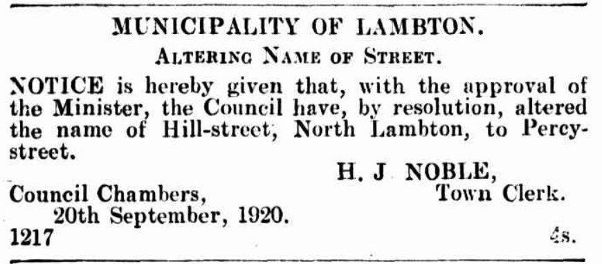
Alderman Lightfoot … moved that the necessary procedure be taken to have the name of Hill-street, North Lambton, changed to Percy-street. It was most confusing to have two streets in the municipality bearing the same name.
Lambton Council Meeting, 18 May 1920.
Background
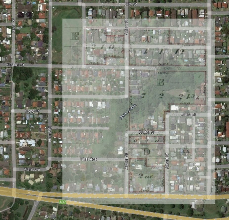
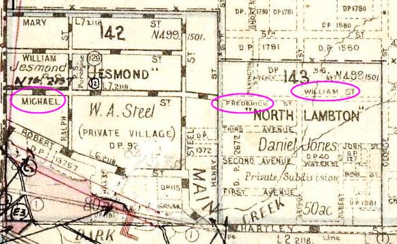
As I was searching through various land titles in the Historical Lands Records Viewer, I found Vol-Fol 1122-48 from 1894, that showed blocks of land between Hill St and William St in North Lambton. This was curious because today, Hill St in North Lambton is nowhere near William St in Jesmond?
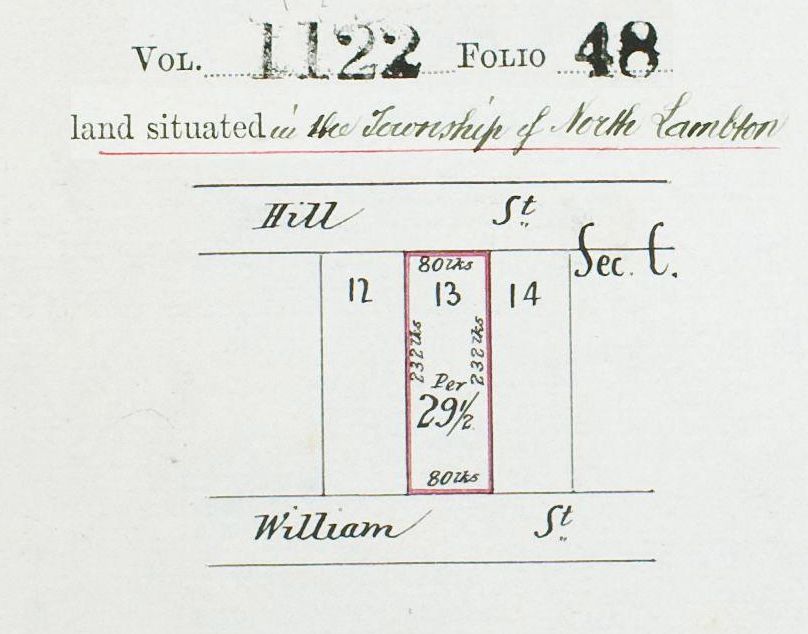
The solution to the mystery is that the Hill St in this map is actually Percy St today, and the William St in the map is the east end of Michael St today.
In 1867, Daniel Jones purchased 50 acres of land between Jesmond and Lambton which he named “North Lambton” (not to be confused with the modern suburb of North Lambton).
In July 1871 Jones sold a large portion (about 16 acres) of the North Lambton subdivision to Doctor John James Hill, who then began reselling individual blocks of land.
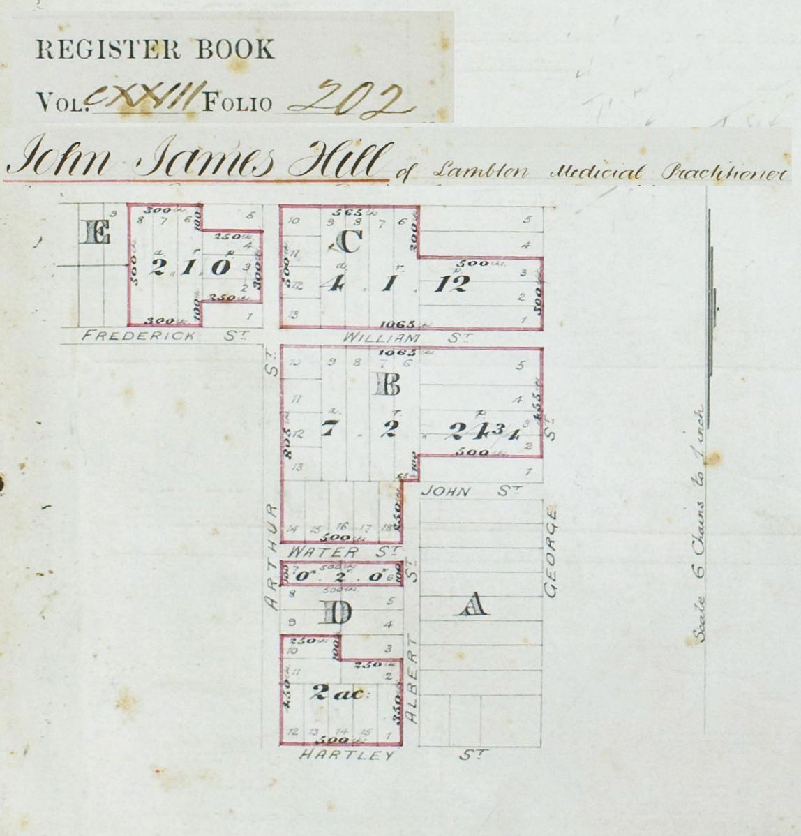
Notice that in this map that “Frederick St” is below section E, and “William St” is below section C. Today this is Michael Street, and whereas the map from Vol-Fol 123-202 shows William St joining on to George St, this part of the street does not exist today and probably never did. This is a good reminder of the care needed to interpret old maps, particularly in land titles and deposited plans. A street marked in an old map can either be an indication of a street that has been built, or a street that is planned to be built. You have to use other evidence to decide which.
In 1873 Doctor Hill lodged Deposited Plan 96, which was a re-subdivision of the land he had bought in Sections C and E of North Lambton.
96 | Hill, J.J. | County of Northumberland | North Lambton, Lambton, Newcastle, re-subdivision of part of Sections C & E on Deposited Plan 40.

There is no map I can find of the DP96 subdivision, but presumably the purpose was to subdivide into a greater number of smaller blocks in order to maximise profit. In the new subdivision, Doctor Hill added an extra street running east-west through the middle of Section C and named it Hill St.
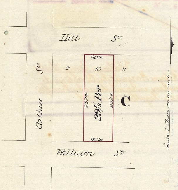
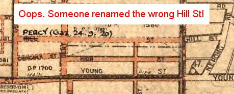
This “Hill St” was then renamed to Percy St in September 1920 to avoid confusion with the original Hill St above High St in Lambton. As if to graphically and ironically underline the need to reduce the confusion caused by having two Hill Streets, in one of the historical parish maps someone has added an annotation renaming the wrong Hill St! Oops.
But wait – there’s more …
The extra other Hill Street
In Hill’s subdivision of Section E in North Lambton, a narrow east-west lane was also added above Hill St. It seems that when Hill St became Percy St in 1920, that this laneway running behind the houses on the north side of Percy St came to be known as Hill St, and is marked as such on some maps.

This lane was a private road in the subdivision until Newcastle Council passed a resolution in 1991 to dedicate it as a public road, and noting that it was “also previously known as Hill Street.”

The name “Wall Lane” was in honour of the Wall family who ran the shop on the south-east corner of Arthur and Percy Streets for many years.

But wait – there’s even more …
The additional extra other Hill Street
Some 500 metres away from Percy Street, opposite Jesmond Park, there is a short stretch of road today that is also named Hill Street, and also named after Doctor Hill.

This Hill Street appears in records as early as 1878, where at the Lambton Council meeting on 26 November 1878 a letter was received …
“… from the Trustees Lambton Building Society dedicating Hill & Abel Streets Jesmond to the Council.”


These two streets were located on Lot 5 Section B of DP92 (Vol-Fol 163-244). This land was mortgaged to the Lambton and Building Investment Society in 1876. In November 1878 when the two streets were dedicated to Lambton Council, Doctor John James Hill was Chairman and Trustee of the Society, and Thomas Abel was Secretary.
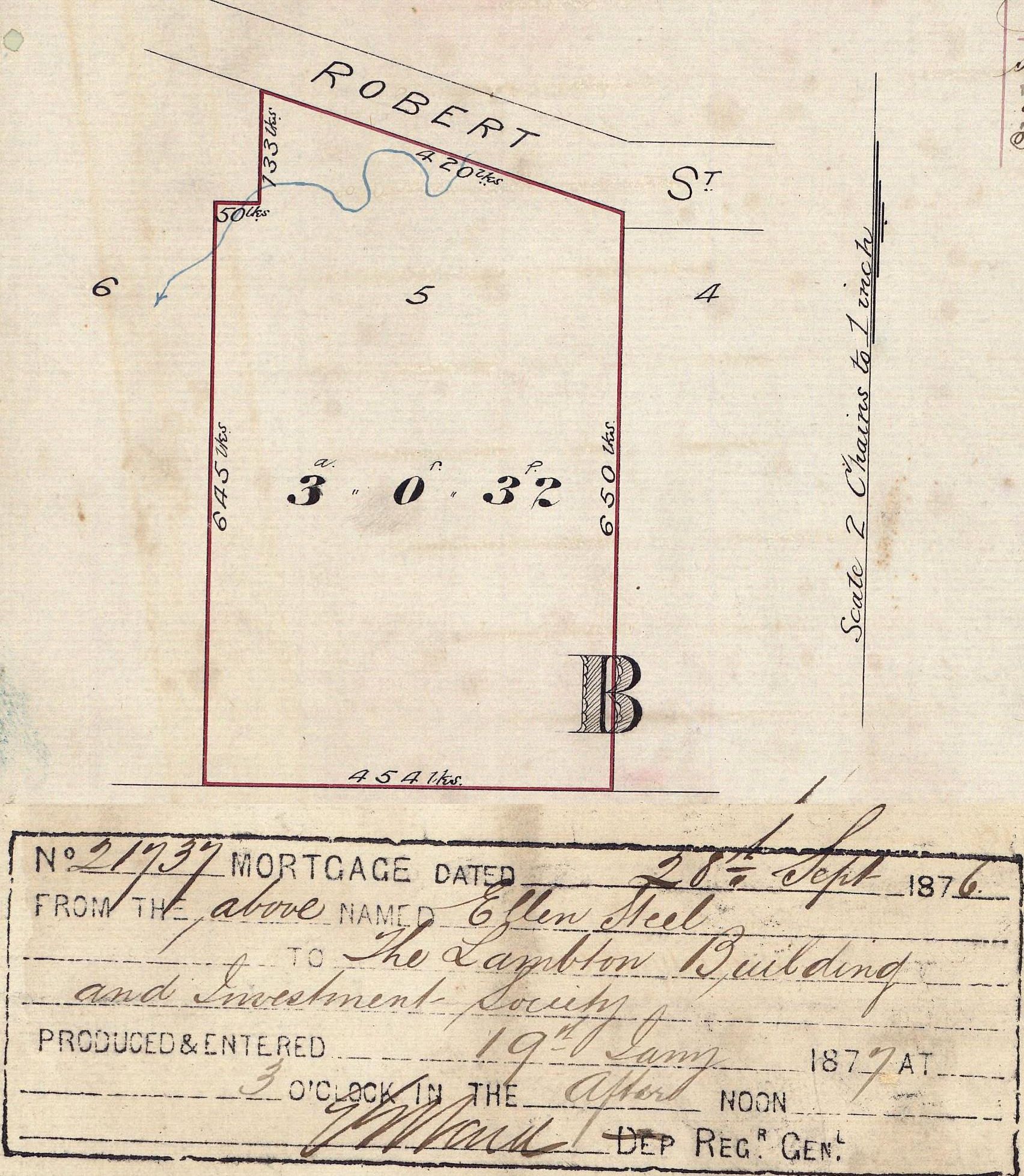
While Hill Street in Jesmond is still there in 2021, Abel Street officially ceased to exist in July 1962 when “in accordance with the provisions of the Public Roads Act, relating to Unnecessary Roads in Our State of New South Wales”, the road was closed. The eastern part of Abel Street was sold to Clarence and Annie Powell, the owners of an adjoining property, and became number 4 Hill St. (See Vol-Fol 8389-31). On the west side, the Anglican church erected a building sometime after 1974. However the transfer of ownership of that little western patch of Abel St was never officially made. This caused some confusion and a costly delay when the Anglican Church sold the property to the non-profit organisation Zara’s House in 2018.


The many monikers of Michael
Earlier in this article I mentioned that what is Michael St today, originally was three differently named sections – Michael, Frederick, William. But that was just in the stretch of road that lay in Lambton municipality – the section of road in the Wallsend municipality had yet another name – Robroy St.

A newspaper article from 1945 titled “Postman’s Headache at Jesmond”, notes that
The street in question, before the advent of Greater Newcastle was Frederick-street from the North Lambton area to Steel-street, Jesmond, Michael-street outwards to the old Lambton-Wallsend boundary, and Rob Roy-street thence to Blue Gum road in the Jesmond area. It is stated that, although it is now all Michael-street, officially, the three names still persist with the uninitiated, and piecemeal house numbering adds to the confusion.
Newcastle Morning Herald and Miners’ Advocate, 5 December 1945.
I grew up on the corner of George Street and ‘the lane’, as everyone called it. It always used to cause plenty of confusion, with people always stopping and looking for the other Hill Street, just up the road. It was my mother who petitioned council to rename it to Wall Lane in the early 90’s, to honour the Wall Family who ran the corner shop on the corner of Arthur and Percy Streets. I remember the Lord Mayor (McNaughton) coming out to unveil the sign.