To avoid duplication, I have moved content originally published in this blog post into my June 2022 “That was then, This is Now” article page.


To avoid duplication, I have moved content originally published in this blog post into my June 2022 “That was then, This is Now” article page.
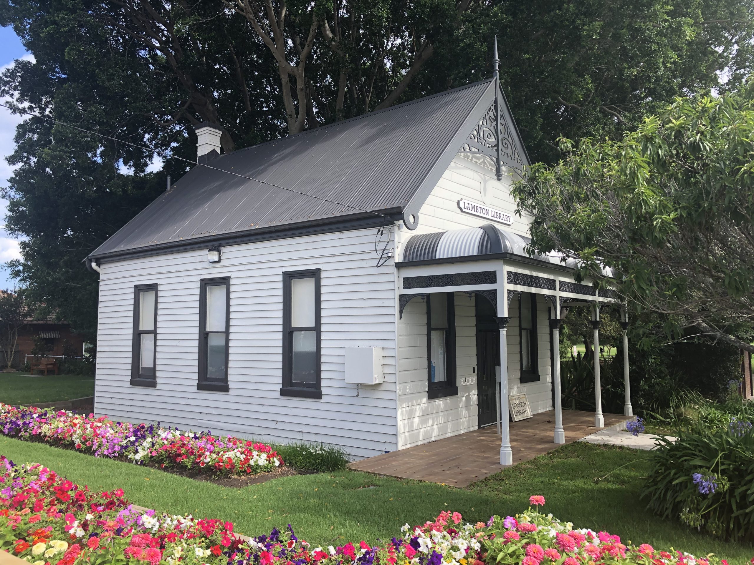
Thanks to the land titles available in the Historical Land Records Viewer, I have been able to identify all the locations that Lambton Council meetings were held during its existence from 1871 to 1938. I have updated my Lambton Council page with this information, including a map.
Of the six buildings they met in, only the last of them still survives – the Lambton Library building in the corner of the park.
My January 2022 column for The Local is out now. This month is on the story behind Lambton Fire Brigade winning this trophy in 1888.

My Christmas treat to myself this year – one of my favourite things – dipping my feet in a cold mountain stream on a hot summer’s day.

My article for the December 2021 issue of The Local is out now, this month on Marshall St and the inner city bypass. The article is titled “A very long road story” for three reasons.

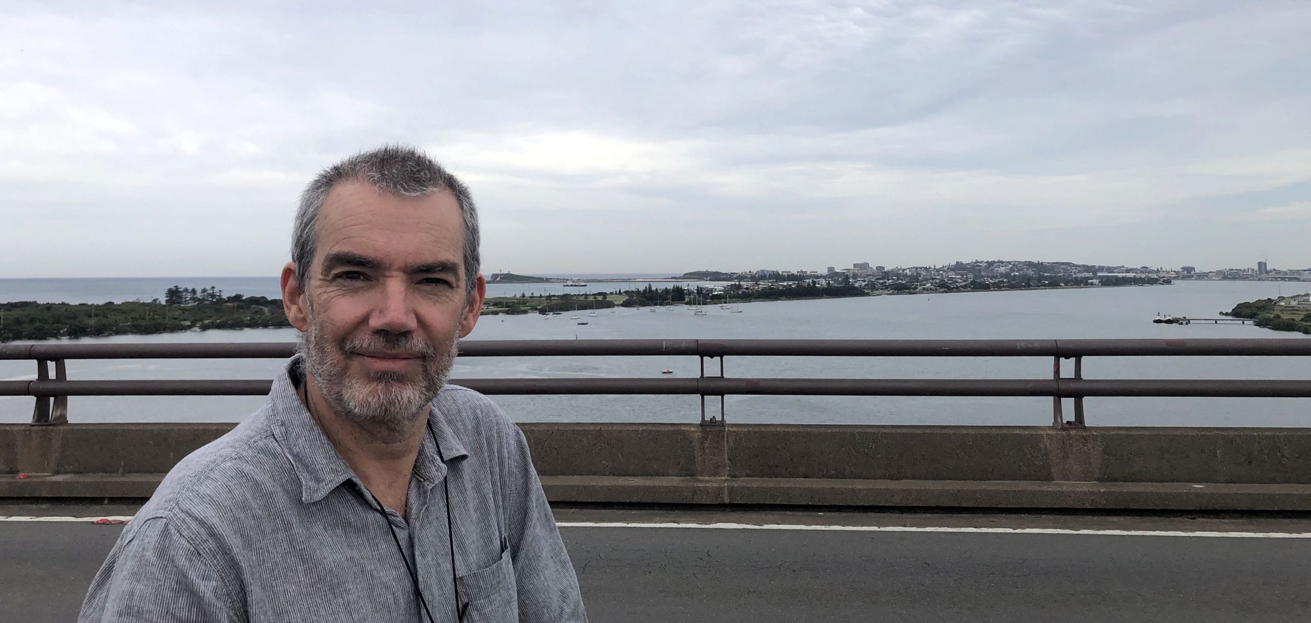
It was 50 years ago today, on 1 November 1971, that Stockton Bridge was officially opened. To mark the occasion, on the weekend I walked over the bridge and took a time lapse video as I traversed it from west to east.
The idea of a bridge from Newcastle to Stockton had been discussed for a long time prior to its construction. In a newspaper article from 10 May 1921, the writer compares Stockton with Manly in Sydney, pointing out the many similarities, and how with a bit of investment in infrastructure Stockton could become a popular tourist destination.
Stockton is almost cheek by jowl with Newcastle, and could be brought closer. Who knows but that some day, in the not too distant future, Newcastle will have its North Shore bridge, to connect the city with its premier pleasure resort at Stockton.
The Newcastle Sun, 10 May 1921.
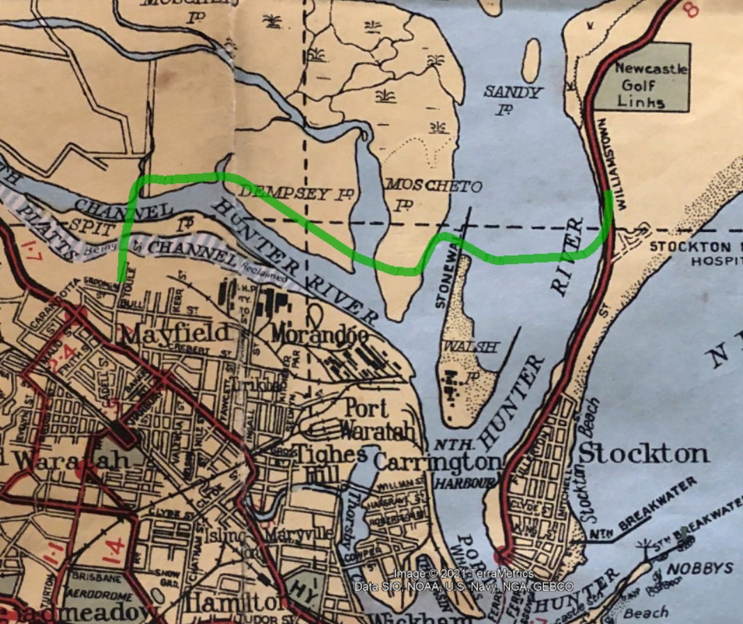
At that time, access between Stockton and Newcastle was via a vehicular ferry, as shown in the circa 1930s map below.

In April 1931, Stockton municipal council in debating the cost of running the vehicular and passenger ferries, suggested that a bridge might possibly be built across Newcastle Harbour from near Fort Scratchley, with the cost of construction to be recouped by tolls over a 20 to 30 year period.
The feasibility, advisability, type of bridge, projected cost, and the preferred route of a Stockton bridge generated many varied and strong opinions.
Surely it would be obvious, even to a child, that the bridge suggested would be of the lifting or swinging type, thus doing away with the unnecessary height. The assertion that the bridge would cost £200,000 is ridiculous, and I still contend that a suitable bridge could be constructed for the trifling sum of £750.
Letter to the editor, Newcastle Sun, 27 July 1932.
Serious consideration of a bridge to Stockton revived in the 1950s when the state government began reclamation of the Hunter River delta islands, to be used for industrial purposes. This reclamation opened up the possibility of a bridge that crossed the river north of Stockton via the reclaimed islands, rather than the more problematic alternative of building a bridge across a busy Newcastle Harbour.
A bridge should be built from Walsh Island to North Stockton in conjunction with the Newcastle harbor reclamation scheme, Mr. L. B. Saddington declared in the Legislative Council yesterday. The bridge would span the north arm of the harbor and connect by road with another planned for the south arm near the B.H.P. Consideration had been given over some years to connecting Stockton with Newcastle proper by bridge or tunnel. Owing to the topography this would be most costly … But one from Walsh Island to North Stockton could be done much more speedily and for less cost.
The Newcastle Sun, 17 September 1953.
Construction of the bridge commenced in 1968, with the erection of the pillars for the approach spans. The Department of Main Roads in 1971 made a very interesting 17 minute documentary on the construction of the bridge, which is available on YouTube.

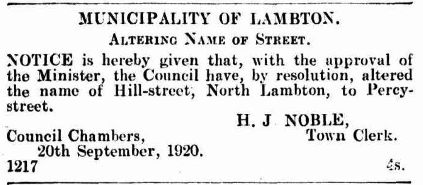
In my article on Doctor John James Hill in March 2017, I wrote that while Hill St in North Lambton was possibly named after Doctor Hill, given the timing of the road naming (first mentioned in 1872) I was sceptical that was the case. However I have since found there was another Hill Street in North Lambton, that almost certainly was named after John James Hill, because it was in a subdivision of land owned by Doctor Hill. This Hill St had its name changed to Percy St in 1920.
Alderman Lightfoot … moved that the necessary procedure be taken to have the name of Hill-street, North Lambton, changed to Percy-street. It was most confusing to have two streets in the municipality bearing the same name.
Lambton Council Meeting, 18 May 1920.
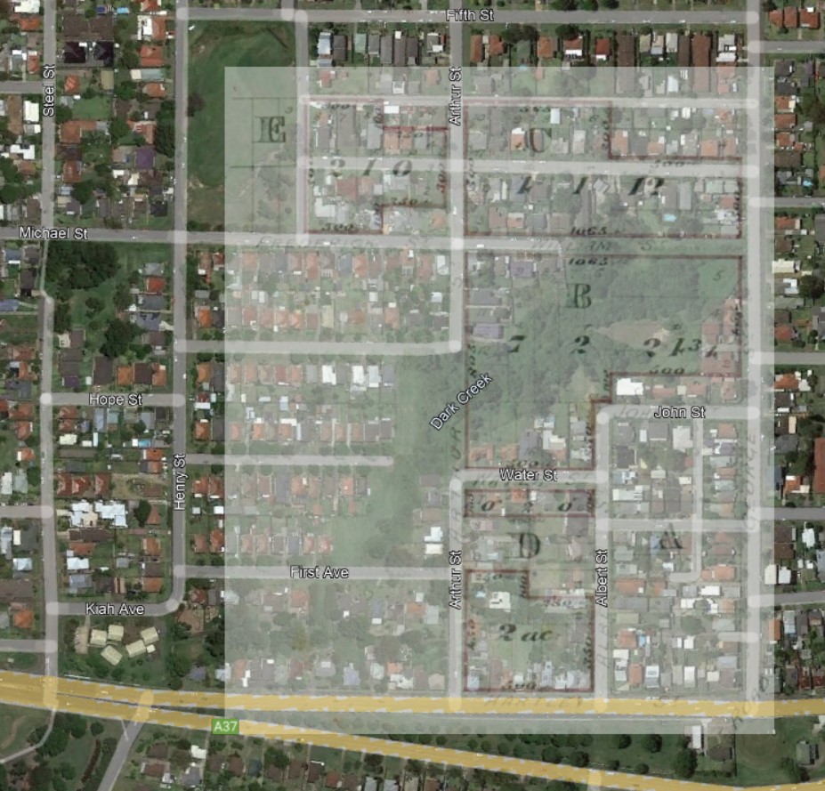
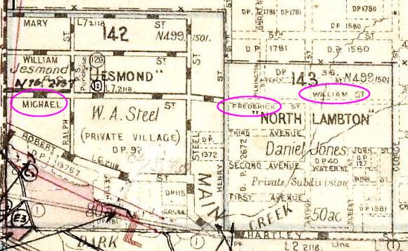
As I was searching through various land titles in the Historical Lands Records Viewer, I found Vol-Fol 1122-48 from 1894, that showed blocks of land between Hill St and William St in North Lambton. This was curious because today, Hill St in North Lambton is nowhere near William St in Jesmond?
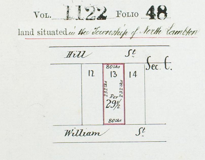
The solution to the mystery is that the Hill St in this map is actually Percy St today, and the William St in the map is the east end of Michael St today.
In 1867, Daniel Jones purchased 50 acres of land between Jesmond and Lambton which he named “North Lambton” (not to be confused with the modern suburb of North Lambton).
In July 1871 Jones sold a large portion (about 16 acres) of the North Lambton subdivision to Doctor John James Hill, who then began reselling individual blocks of land.
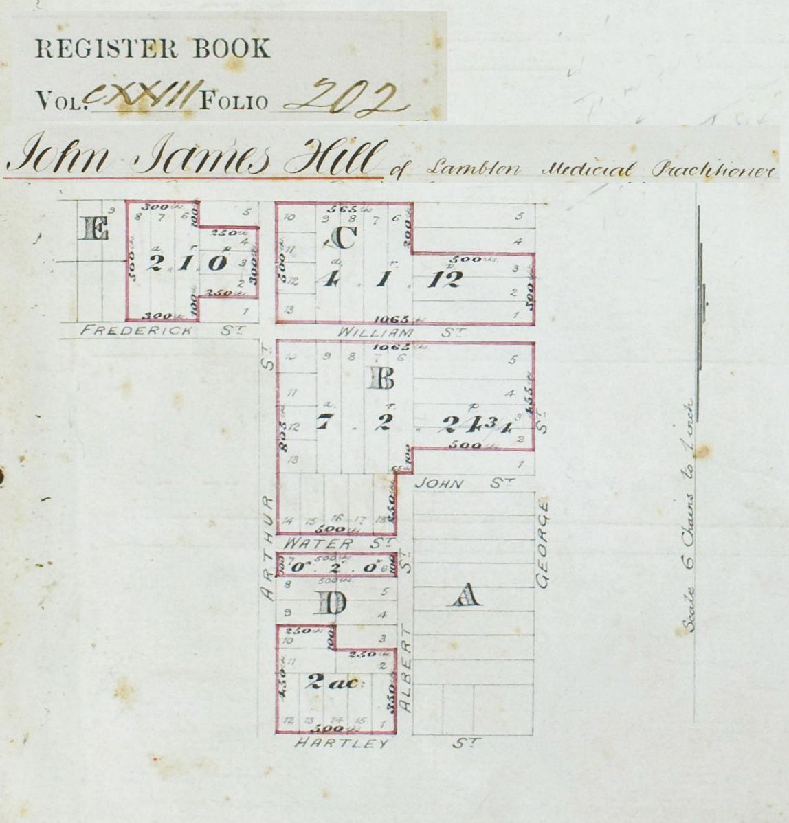
Notice that in this map that “Frederick St” is below section E, and “William St” is below section C. Today this is Michael Street, and whereas the map from Vol-Fol 123-202 shows William St joining on to George St, this part of the street does not exist today and probably never did. This is a good reminder of the care needed to interpret old maps, particularly in land titles and deposited plans. A street marked in an old map can either be an indication of a street that has been built, or a street that is planned to be built. You have to use other evidence to decide which.
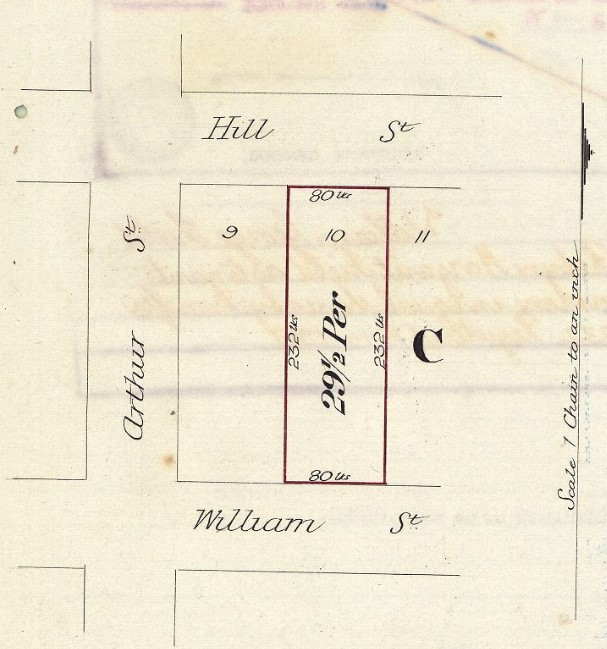
In 1873 Doctor Hill lodged Deposited Plan 96, which was a re-subdivision of the land he had bought in Sections C and E of North Lambton.
96 | Hill, J.J. | County of Northumberland | North Lambton, Lambton, Newcastle, re-subdivision of part of Sections C & E on Deposited Plan 40.

There is no map I can find of the DP96 subdivision, but presumably the purpose was to subdivide into a greater number of smaller blocks in order to maximise profit. In the new subdivision, Doctor Hill added an extra street running east-west through the middle of Section C and named it Hill St.
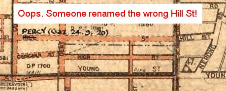
This “Hill St” was then renamed to Percy St in September 1920 to avoid confusion with the original Hill St above High St in Lambton. As if to graphically and ironically underline the need to reduce the confusion caused by having two Hill Streets, in one of the historical parish maps someone has added an annotation renaming the wrong Hill St! Oops.
But wait – there’s more …
In Hill’s subdivision of Section E in North Lambton, a narrow east-west lane was also added above Hill St. It seems that when Hill St became Percy St in 1920, that this laneway running behind the houses on the north side of Percy St came to be known as Hill St, and is marked as such on some maps.

This lane was a private road in the subdivision until Newcastle Council passed a resolution in 1991 to dedicate it as a public road, and noting that it was “also previously known as Hill Street.”

The name “Wall Lane” was in honour of the Wall family who ran the shop on the south-east corner of Arthur and Percy Streets for many years.

But wait – there’s even more …
Some 500 metres away from Percy Street, opposite Jesmond Park, there is a short stretch of road today that is also named Hill Street, and also named after Doctor Hill.

This Hill Street appears in records as early as 1878, where at the Lambton Council meeting on 26 November 1878 a letter was received …
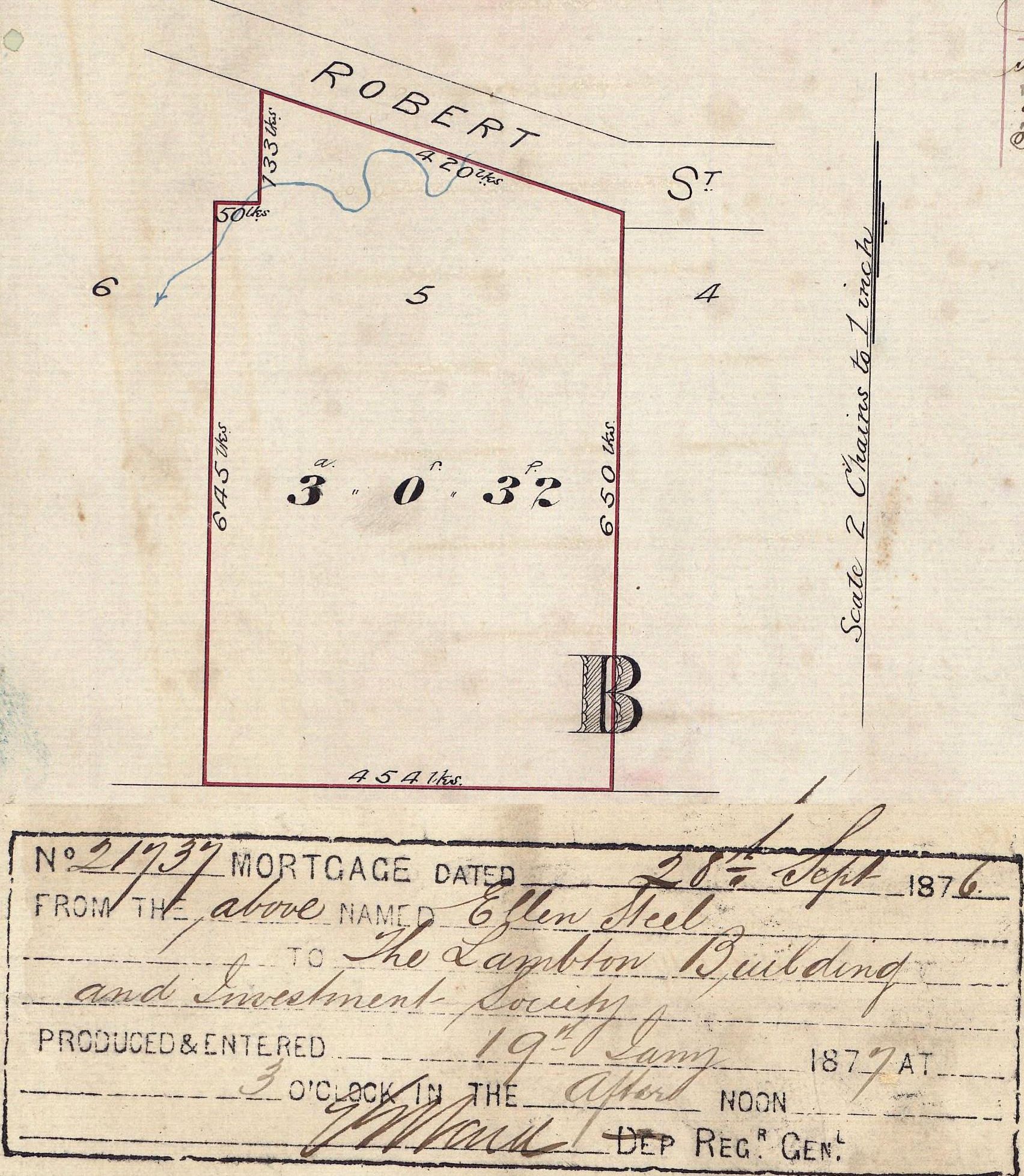
“… from the Trustees Lambton Building Society dedicating Hill & Abel Streets Jesmond to the Council.”


These two streets were located on Lot 5 Section B of DP92 (Vol-Fol 163-244). This land was mortgaged to the Lambton and Building Investment Society in 1876. In November 1878 when the two streets were dedicated to Lambton Council, Doctor John James Hill was Chairman and Trustee of the Society, and Thomas Abel was Secretary.
While Hill Street in Jesmond is still there in 2021, Abel Street officially ceased to exist in July 1962 when “in accordance with the provisions of the Public Roads Act, relating to Unnecessary Roads in Our State of New South Wales”, the road was closed. The eastern part of Abel Street was sold to Clarence and Annie Powell, the owners of an adjoining property, and became number 4 Hill St. (See Vol-Fol 8389-31). On the west side, the Anglican church erected a building sometime after 1974. However the transfer of ownership of that little western patch of Abel St was never officially made. This caused some confusion and a costly delay when the Anglican Church sold the property to the non-profit organisation Zara’s House in 2018.


Earlier in this article I mentioned that what is Michael St today, originally was three differently named sections – Michael, Frederick, William. But that was just in the stretch of road that lay in Lambton municipality – the section of road in the Wallsend municipality had yet another name – Robroy St.

A newspaper article from 1945 titled “Postman’s Headache at Jesmond”, notes that
The street in question, before the advent of Greater Newcastle was Frederick-street from the North Lambton area to Steel-street, Jesmond, Michael-street outwards to the old Lambton-Wallsend boundary, and Rob Roy-street thence to Blue Gum road in the Jesmond area. It is stated that, although it is now all Michael-street, officially, the three names still persist with the uninitiated, and piecemeal house numbering adds to the confusion.
Newcastle Morning Herald and Miners’ Advocate, 5 December 1945.
My October 2021 article for The Local is out, this month on William Thomas Dent.
Often my research for these articles leads me in unexpected directions, and this month was no exception taking me to the short lived Hartley Vale colliery of James and Alexander Brown in the Broadmeadow area, and all the way to the other side of the world to the coalfields of Durham where William’s father Mark Dent was a key figure in the great miners’ strikes of 1844 .
One of the things that struck me about the story of the Dent family is how much things can change in the space of one generation. Because of his involvement in the miners strikes, Mark Dent found it hard to get work, was subject to poverty and was “driven from his native land” to seek a living in Australia. William arrived in Australia after his father, lived and worked in a coal mining community, grew wealthy as the head of major financial institution, was an alderman for 17 years, many of them working co-operatively alongside Thomas Croudace the Lambton colliery manager.
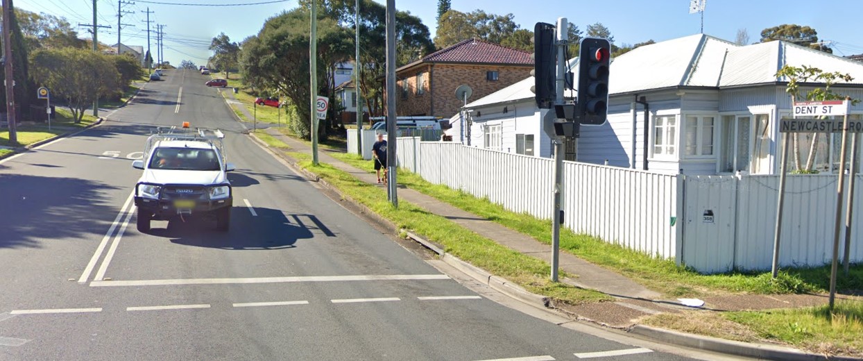
The unexpected find from this month’s research is that Dent St North Lambton is probably named in honour of Mark Dent the famed mining unionist who died in Lambton in 1882, rather than William Thomas Dent who was only a relatively junior alderman at the time Dent St was named.