A couple of years ago I posted an article and some photos of a Douglas C47 transport aircraft that ended up in the storm water drain beside the Broadmeadow aerodrome during World War 2.
Last year I was examining an old black and white aerial photograph of the Broadmeadow area, and spotted something interesting …
… could that be the crashed C47 in the drain?
The aerial photograph has an information panel along the bottom, and in the white shape next to “RUN 5” there is some very faint writing.
The writing is too faint to decipher with any certainty in this “RUN 5” photograph, but in a similar photograph from “RUN 7” the date of the photograph is clearly 3rd September 1944.
This is just three weeks after the 10th August 1944 crash of the aircraft, and confirms that it is indeed the C47 plane we can see in the aerial photograph.
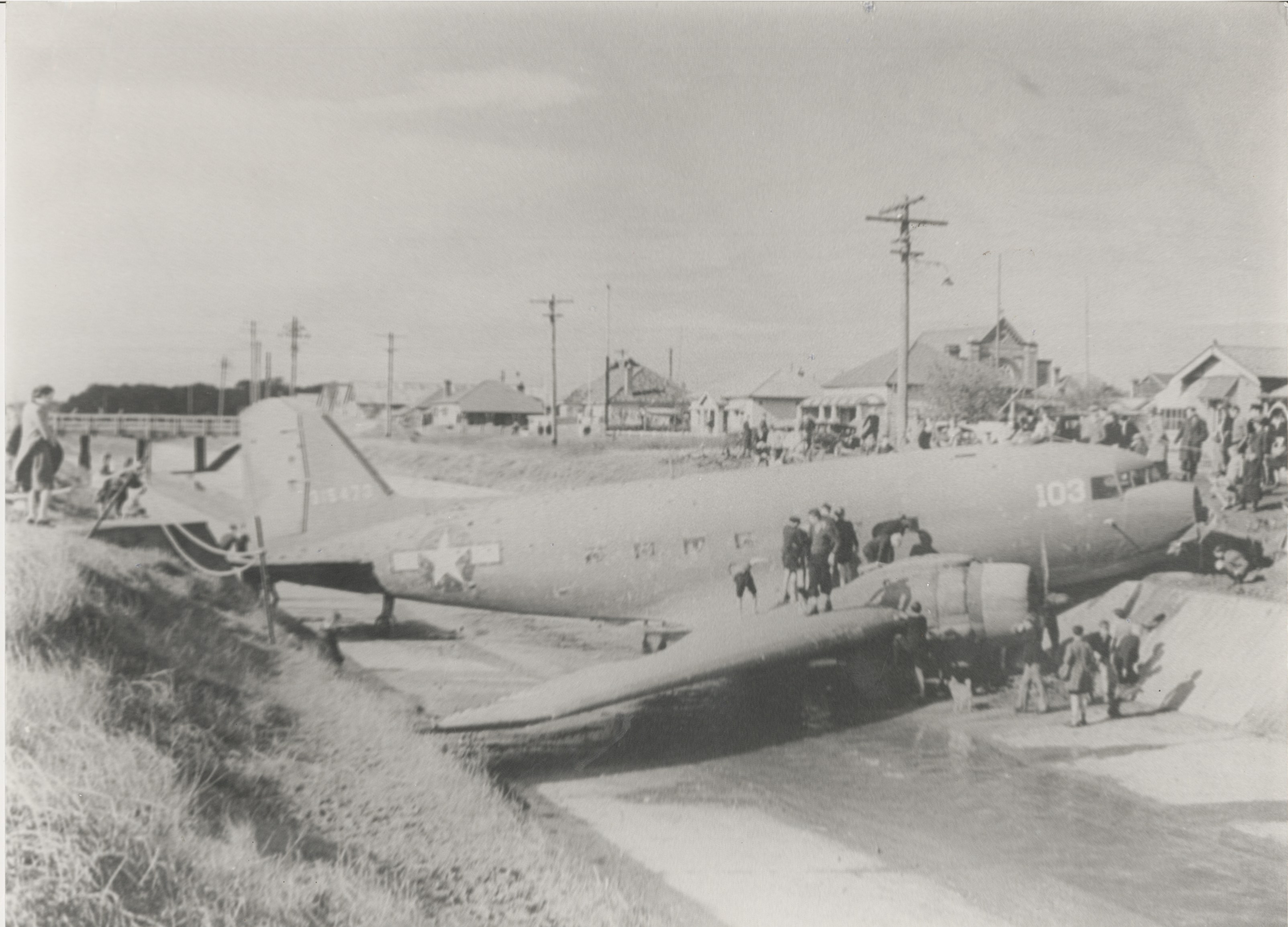
Photograph of the crashed Douglas C47 transport plane, from the Newcastle Morning Herald, 12/8/1944. New Lambton can be seen in the background.
A D.C. 47 Army transport plane, with 25 men on board, skidded 200 yards on a wet runway, hurtled through a fence and then crashed into a stormwater channel at Broadmeadow aerodrome.
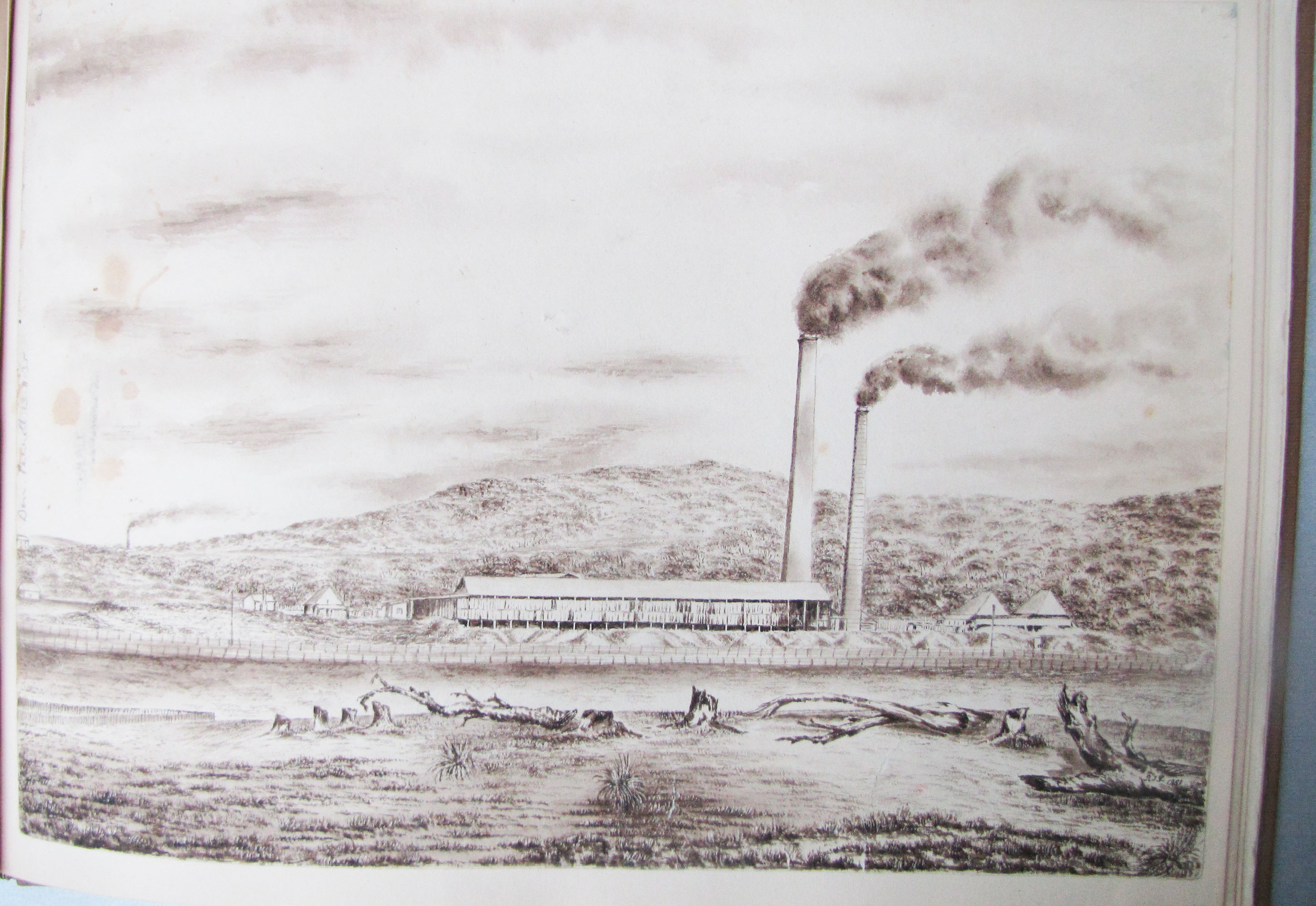
The Hunter Living Histories site has just published an article on Robert Perrott, including some sketches he did of various places around Newcastle in the late 1800s. Of particular interest is a sketch of the copper smelting works near Waratah.
Copper smelting near Waratah, at Newcastle. (Sketch by Robert Perrott, Mitchell Library, State Library of NSW)
This was the works of the English and Australian Copper Smelting Company, which commenced operation in 1872. The Maitland Mercury reported on 18 June 1872 …
On Tuesday last a very interesting ceremony was performed by the Mayor of Waratah in the presence of the local manager of the establishment and a few gentlemen from Newcastle, namely, that of lighting the first fires in two of the copper smelting furnaces of the English and Australian Copper Smelting Company’s works near Waratah.
The smelter operated for about 47 years, and the land was sold off in 1918 and 1919, as reported by the Maitland Mercury on 6 Nov 1919.
A 1910 map by A. Barrett shows that the smelter was situated in modern day Broadmeadow, where UGL Limited (formerly Goninans) is now located.
1910 Barrett map overlaid on Google Earth, showing the location of the copper smelter near Waratah.
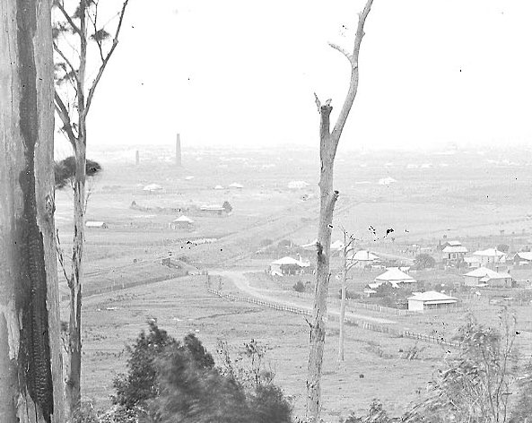
The smelter had two large brick smokestacks, that were highly visible points in the landscape, and often appeared in the background of photographs of the time.
View from New Lambton towards Broadmeadow, with copper smelting stacks in the background. circa 1887. University of Newcastle, Cultural Collections.
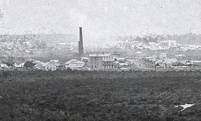
Stormwater drain construction at Hamilton North., April 1900, looking towards New Lambton. The Waratah copper smelter stack is visible in the background. University of Newcastle, Cultural Collections.
View of Waratah copper smelter from Glebe Rd Hamilton South in 1897. University of Newcastle, Cultural Collections.
An interesting aspect of the Perrott sketch of the smelter, is how some details are quite accurate, but other details not so accurate, probably for aesthetic reasons. When we compare the sketch with a 1906 Ralph Snowball photograph of Waratah taken from somewhere near the present day Mater hospital, we see that Perrott has reproduced the smelter building and stacks reasonably accurately. However in the sketch the smelter appears to be at the base of a hill, but the smelter was actually located on the flat plain of Broadmeadow, and that hill is Merewether Heights some 4km in the distance.
Sketch of Waratah copper smelter by Robert Perrott.
Photograph of Waratah copper smelter by Ralph Snowball, 1906. University of Newcastle, Cultural Collections.
"The English and Australian Copper Company, who carry on extensive smelting works in South Australia, are about to establish similar works within a mile of New Lambton.
Construction of the English and Australian copper smelting works at Broadmeadow has been in progress for three months, and smelting "will be commenced in about two months." (This was a wildly optimistic estimate, as smelting eventually commenced in June 1872, more than two years later.)
The manager is "Mr. Christoe, a gentleman of great experience in copper-smelting."
The weather has significantly delayed the opening of the smelter.
"For upwards of two months there was such an accumulation of water at the establishment as to defy the possibility of the works being proceeded with, and thus the company were unexpectedly debarred from carrying out their design in the contemplated time as regards the inauguration of the process of smelting."
250 tons of copper ore have arrived in Newcastle Harbour destined for the New Lambton Copper-smelting Works so "now there is a reasonable hope that this fine and valuable property created here
at a great expense, will very shortly become utilised."
"There appears to be an anomaly existing between our copper- smelting establishments, which time only can set at rest ; for while at this establishment five furnaces are idle for want of ore, at the Hunter River Works, five furnaces are idle here from the want of men acquainted with smelting operations to work them."
Smelting of ore has ceased.
"The business of the company during the past year had to be conducted under conditions of great risk and anxiety, which finally forced the board reluctantly to instruct the manager in Australia to cease making purchases of ore, to smelt out all copper available, and to close the smelting works, a process that has been
carried through."
"The long connection of the English and Australian Copper Company, Limited, with the Newcastle district has been finally severed through its having recently sold the land that was the site of the works, known
as the Waratah works."
Although I didn’t intend it when I set out, a bike ride with my son around town today ended up visiting various sites in Newcastle matching the old photos in my previous drain blog post. Here’s the “Then and Now” comparisons.
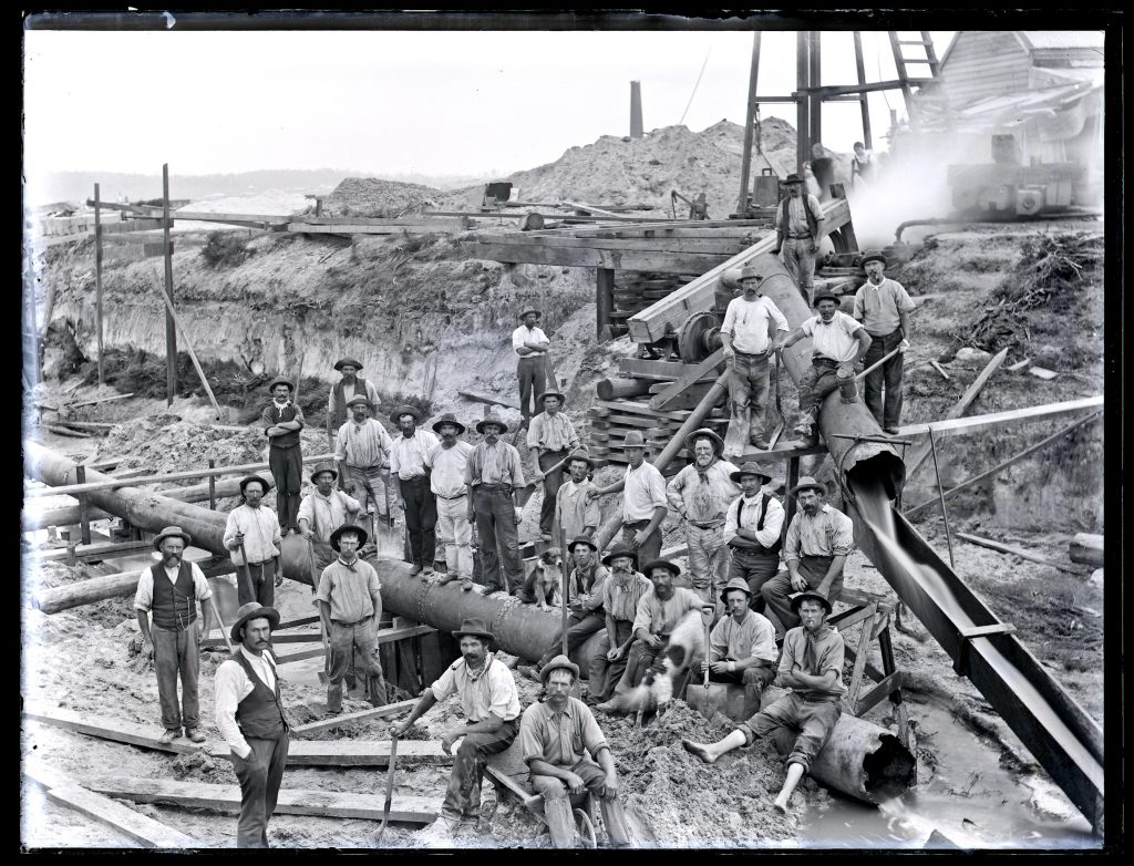
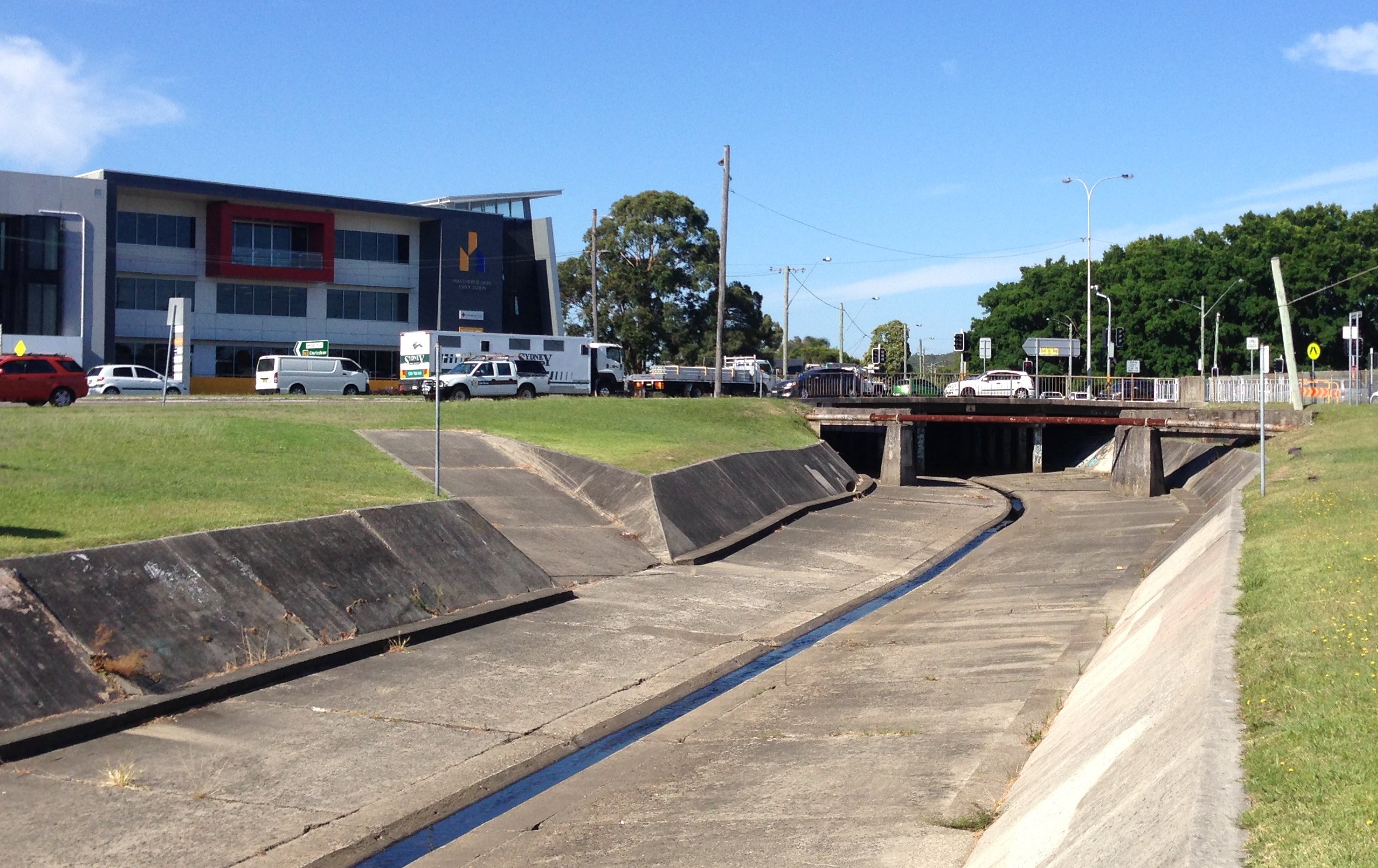
Broadmeadow drain
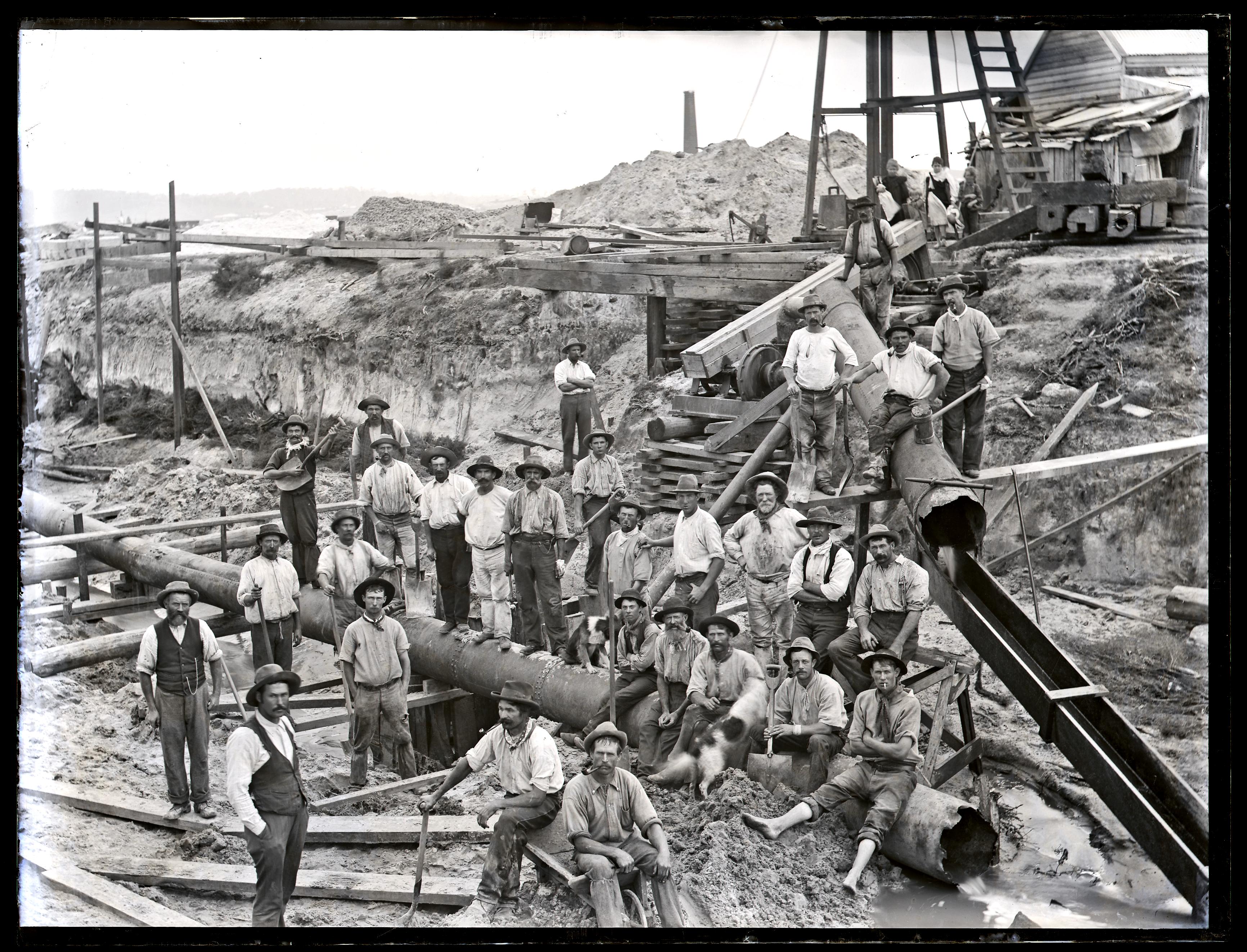
Drain construction workers at Broadmeadow, NSW, 6 April 1900
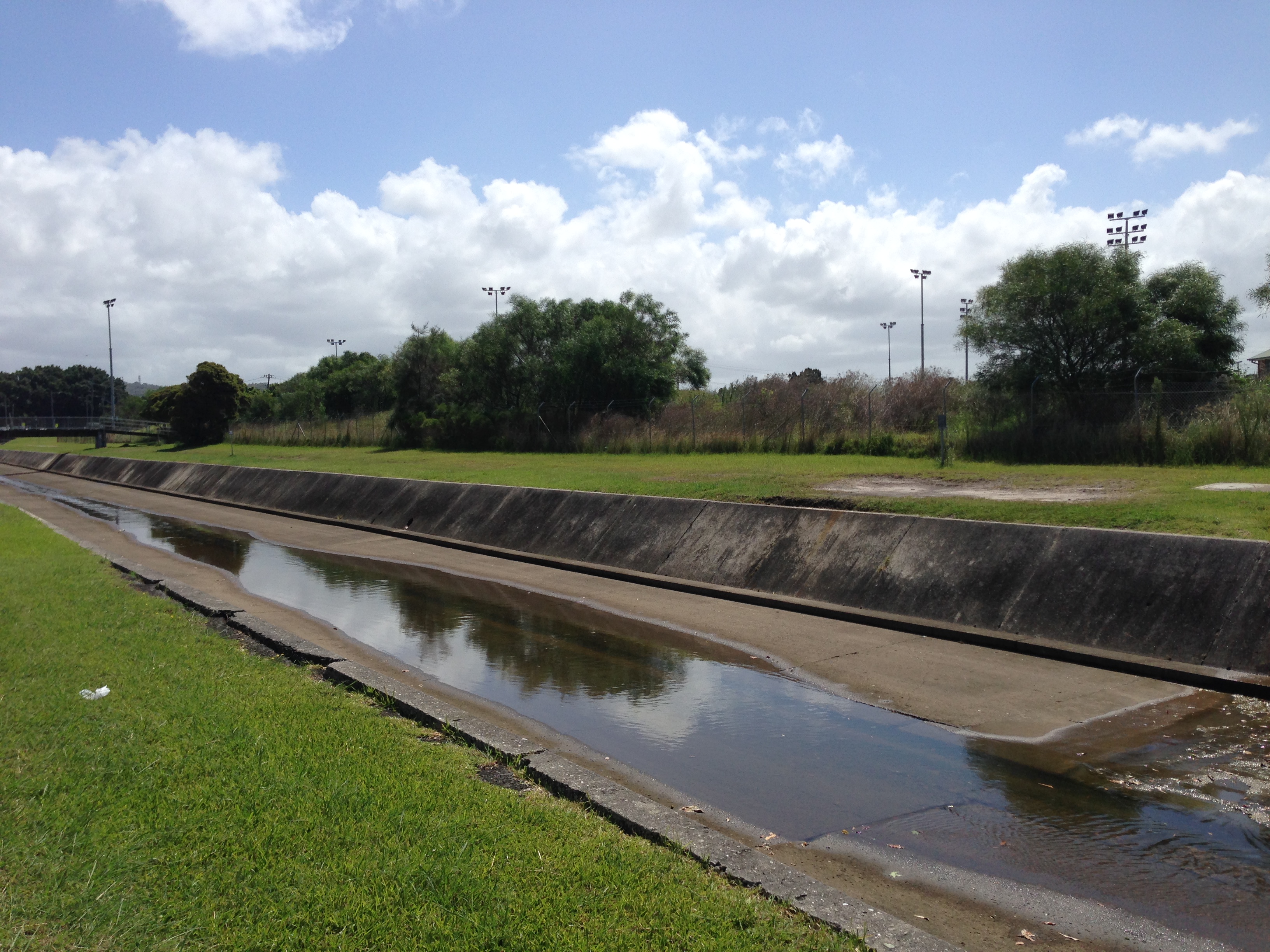
Broadmeadow drain, 6th February 2016.
The stormwater drain at Hamilton North, March 2017.
Update, March 2017: With subsequent research I have found that the location of the 1900 Snowball photo was Hamilton North, not Broadmeadow.
The Premier Hotel
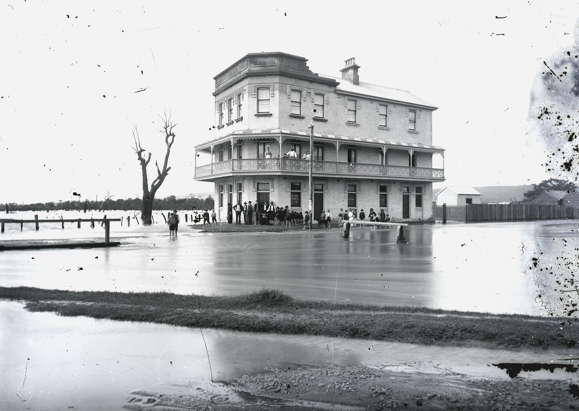
Premier Hotel, Broadmeadow, 1892. Photo by Ralph Snowball. University of Newcastle Cultural Collections.
Premier Hotel, 6th February 2016.
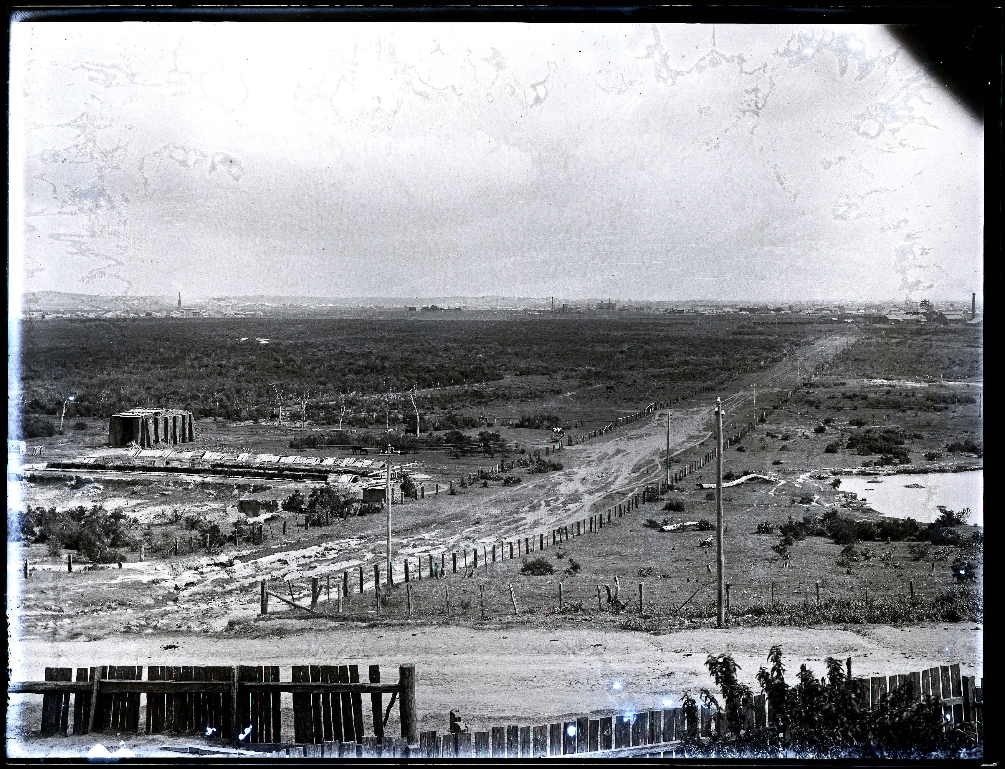
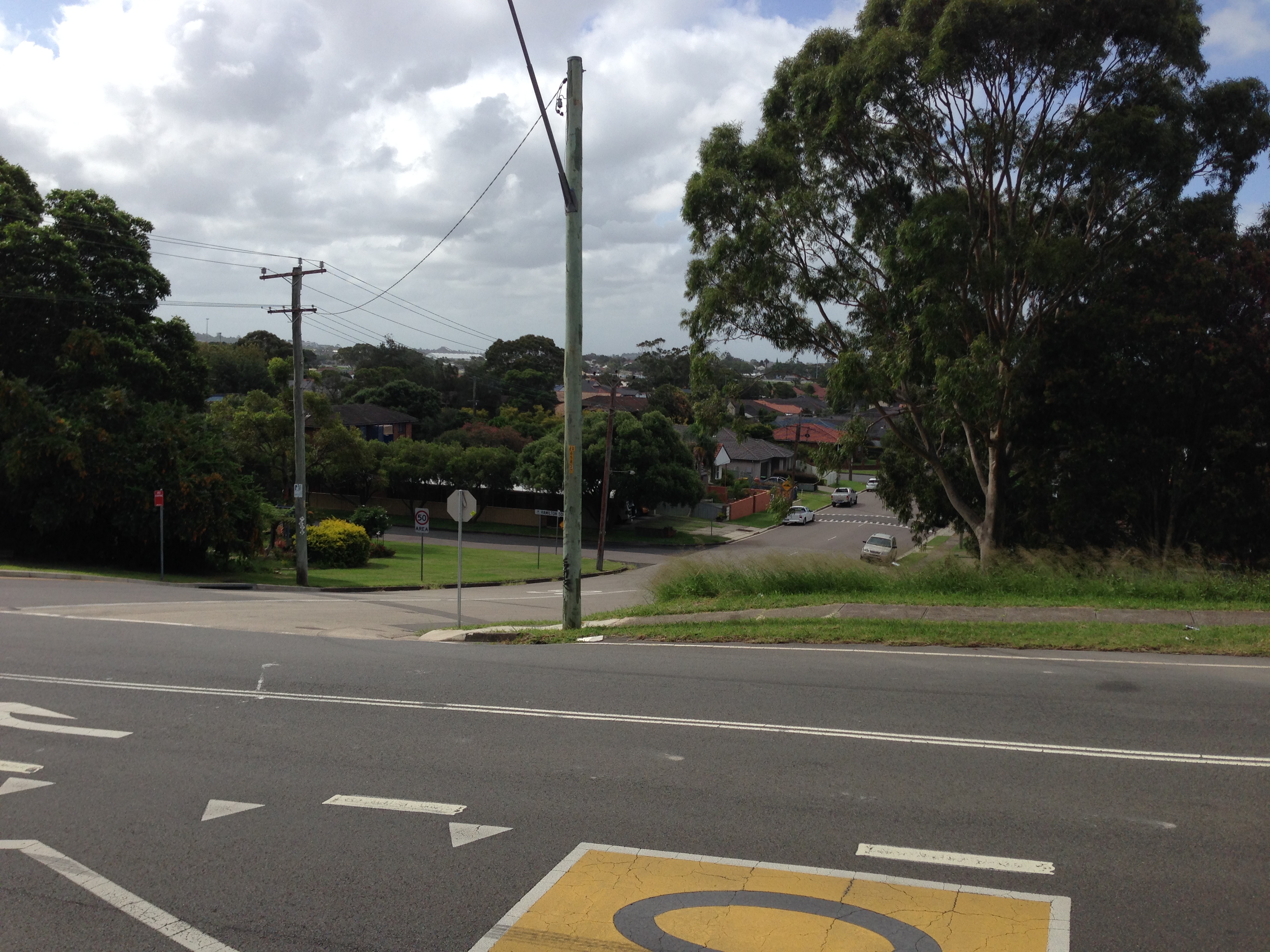
View of the lowlands from Glebe Road
The Newcastle lowlands. 1897. Photo taken from intersection of Beaumont St and Glebe Rd looking north towards Hamilton. University of Newcastle Cultural Collections.
Looking north from Glebe Rd towards Hamilton. 6th February 2016.
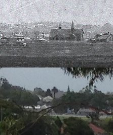
This modern view bears almost no resemblance to the 1897 photo, with the previously deserted lowlands now covered with trees, suburbia and industry. The only visible match (apart from Beaumont St sloping down the hill) is a spire of St Peter’s Anglican church in Denison St Hamilton.
St Peters Anglican Church Hamilton
St Peter’s Anglican Church Hamilton.
It seems that at some time the church has lost one of its spires.
Back in 2014 a change of residence meant that my bicycle commute to work changed to a route that took me alongside long stretches of the concrete drains that spider across the low lying Newcastle suburbs. For 85% of my commute to work I am within 200 metres of one of the concrete drains, or Throsby Creek.
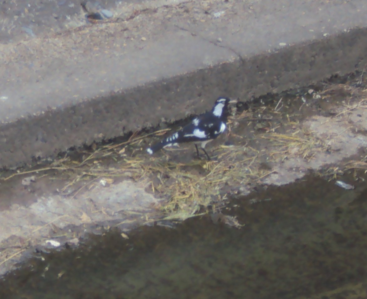
In a recent conversation with a friend when I mentioned this, they responded with some expression of sympathy and sadness that I had to endure such an ugly travelling companion. As I reflected on this reaction I realised that although the drains are not exactly the most aesthetic feature of our city, there are a number of positives.Firstly, cycling alongside the drains offers relative serenity, in comparison to busy roads. Secondly, the drains often attract a variety of bird life – ducks, ibises, some other kinds of birds, the black and white ones, the fast darting ones, as well as those little fluttery ones. (As much as I like birds, you might correctly guess I’m no ornithologist!)
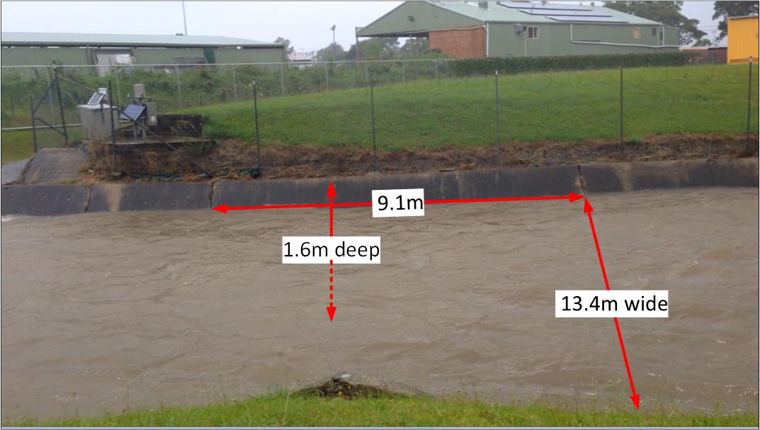
In thinking about the concrete drains I’ve also been pondering their principal purpose – to drain away water. In the downpours of January 2016 I saw this fully in action, and recorded this video of the drain in Broadmeadow near the rescue helicopter base.
It got me thinking. How much water was being carried away each second? Stepping through the frames on the video I was able to see that it took 2.94 seconds for the flow to pass from one concrete seam in the drain to the next. A visit to the drain a few weeks later (when it was dry) to take some measurements revealed the following.
[ Note that all these measurements and calculations are ‘back of the envelope’, ‘ballpark figures’ for the purpose of gaining a broad sense of the capabilities of the drain, and not a precise hydrological survey. ]
I’ve also been pondering the economic benefit of these drains. Prior to their construction from 1895 onwards, the lowlands of Newcastle were regularly turned into a useless boggy swampland. A 1892 description of Broadmeadow states that:
“When there are heavy rains the water comes down in such a way as to flood the streets and property, the water being sometimes 12 and 18 inches deep on the streets.”
Premier Hotel in Broadmeadow surrounded by flood waters in 1892. Photo by Ralph Snowball. University of Newcastle Cultural Collections.
The 1897 Ralph Snowball photograph below looking from Glebe Rd Merewether across to Hamilton graphically illustrates the large plain of unused and unusable land, and with the roads suffering significant water erosion.
The Newcastle lowlands, 1897. Photo taken from intersection of Beaumont St and Glebe Rd looking north towards Hamilton. University of Newcastle Cultural Collections.
Even as construction was progressing the economic benefit of drainage was clear to see, with an 1897 newspaper report on the extension of the system into Adamstown noting that:
“Its construction will prove a great boon to those residing on the lowlands, and should increase the value of property materially.”
Drain construction workers at Broadmeadow, NSW, 6 April 1900. University of Newcastle Cultural Collections.
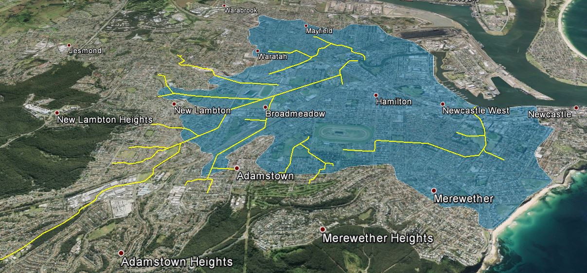
The question then is what is the area of the “lowlands” that are emptied by the drainage system? Browsing the altitude data in Google Earth, and observing the landscape around town, 15 metres above sea level seems to be the inflection point where a gradual rise in elevation across the plains changes to a steeper inclinaton of the surrounding hills and ridges. Using Google Earth I marked with yellow lines the concrete drains, and mapped out in blue the area of the drainage basin that is 15m or less above sea level. This area totalled approximately 1850 hectares. [ KML file viewable in Google Earth ]
[ Note, as before, this mapping is a rough approximation for the purpose of gaining a broad sense of the capabilities of the drainage system, and not a precise hydrological survey. ]
Newcastle concrete drain system. Area shaded blue is 15m or less above sea level.
As an aside, when I first viewed the map of the drains against the shaded lowlands, it immediately struck me that there is a large area centred on Hamilton that has no open concrete drains, and my recollection is that in the June 2007 Pasha Bulker storm, Hamilton was one of the main areas of flooding. Coincidence or not? I don’t know, as I keep reminding you, I’m not a hydrologist.
Nor am I an economist. With that final disclaimer out of the way I can now ask, how much is all that land worth? What is the monetary value of the land made productive by the open concrete drain system? As an example of land values, the NSW Valuer General shows that in 2015 a 424 m2 area of land in Hamilton North had a value of $327,000. This equates to $771 per square meter, or $7.7 million per hectare. If we assume that only 75% of the 1850 hectares is usable (allowing for roads, creeks, etc) then the total land value of the lowlands shaded in the map above is … 10.7 billion dollars!
So the next time you pass one of those ‘ugly’ concrete drains … give a bit of respect.
Back in December 2014 I did a “Then and Now” comparison of the drain at the Gully Line intersection at Broadmeadow. Courtesy of the recent downpours I now present a “Wet and Dry” comparison.
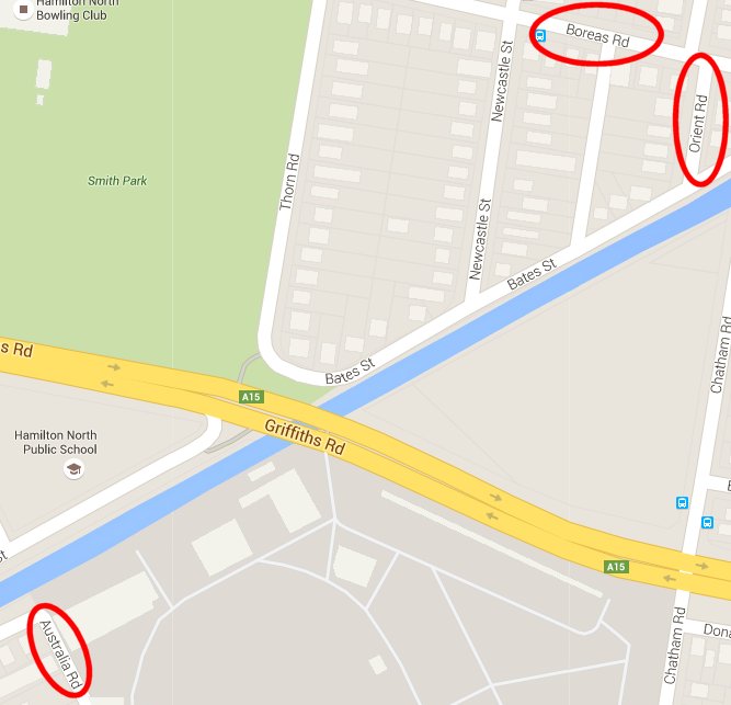
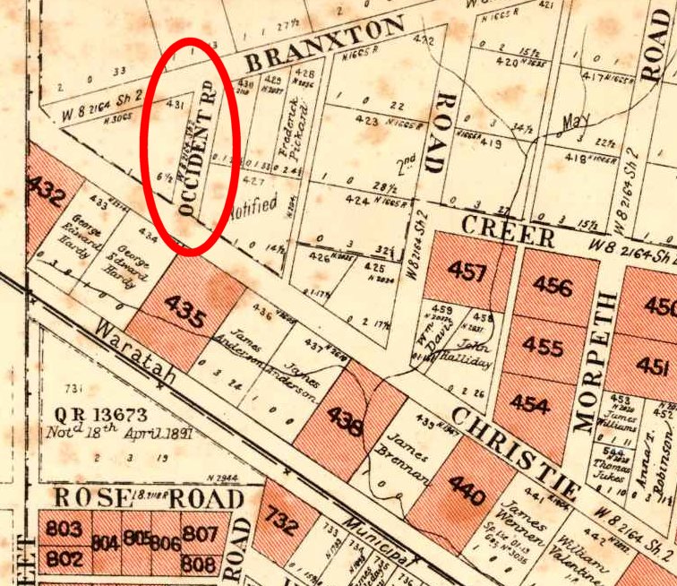
A couple of months ago in an e-mail conversation with Mark Maclean we noted that in Hamilton North and Broadmeadow there is a “Boreas St” (North) and an “Orient St” (East) and an “Australia Rd” (South). I jestingly wondered about the missing compass point, and the whereabouts of “Occident Rd” (West).
I actually did a search on Google Maps and found that the closest was an “Occident St” in Nulkaba, which interestingly has a companion “Boreas St” and “Austral St”, but is missing an “Orient St”.
Then a few days ago when I was putting together the web page for my January 2016 article for the Lambton Local, I accidentally and serendipitously discovered on a 1906 real estate map that there was an “Occident Rd”, in neighbouring Waratah West!
This road was closed in 1910, and Christo/Christie Rd shortened.
By overlaying the old map onto Google Earth you can get a sense of where Occident Rd used to be, in the area which is now part of the Acacia Avenue Reserve.
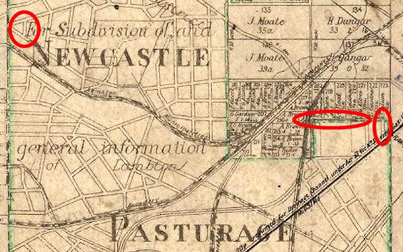
So is there any intentional connection between these streets? I have seen no direct evidence of this, but it is somewhat suggestive that when you look at a map of the Newcastle Pasturage Reserve (below) where the reserve boundary is marked in green, that Occident Rd is adjacent to the west boundary, Orient St is adjacent to the east boundary and Boreas St is on a north boundary of the reserve. Coincidence or not? Unfortunately Australia St is not near any boundary.
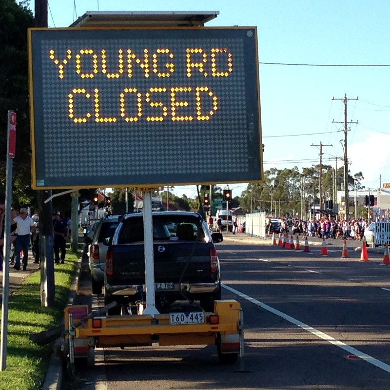
My latest article in the Lambton Local has been published – this month on the great debate over the route of the main road to town in the 1870’s. Oh boy, what a saga of local rivalries and government equivocation to match the great rail line truncation debate we’ve experienced lately.
Even after Young Rd lost out to being the main road to town, it had a rather troubled story and quite a few battles fought over it. You can read all about it in the details page for my article, and see how we came to the situation today where Young Rd is in two separate sections – one in Lambton, and the other in Broadmeadow.
For years I was curious why the main road from Wallsend into Newcastle had so many names … Newcastle Rd, Griffiths Rd, Donald St. It turns out that the substantial traffic corridor into town that we see today is a relatively recent patchwork of disparate roads connected together.
In Lambton’s early days the roads between townships and into Newcastle were unplanned tracks meandering across the landscape. In 1874 the residents of Lambton and other communities agitated for the government to construct a proper road from Wallsend to Newcastle, noting in a public meeting on 23rd April 1874 “that, up till the year 1873, no road, except a bush road, has existed”. Although there was broad agreement that a new road was needed, there was considerable disagreement on where to build it, some supporting a northern route via Young Rd and others a southern route through New Lambton. The disagreement was so heated that the public meeting ended in great confusion and no decision when “every symptom of a free fight became apparent.”
The dispute was so dogged in the following months that eventually the Government approved the construction of both roads. Ninety years on however, neither route was the main road. In the 1960s and 70s, Newcastle Rd was widened, Griffiths Rd constructed, and the Donald St railway overpass erected to form the four lane road to town we know today.
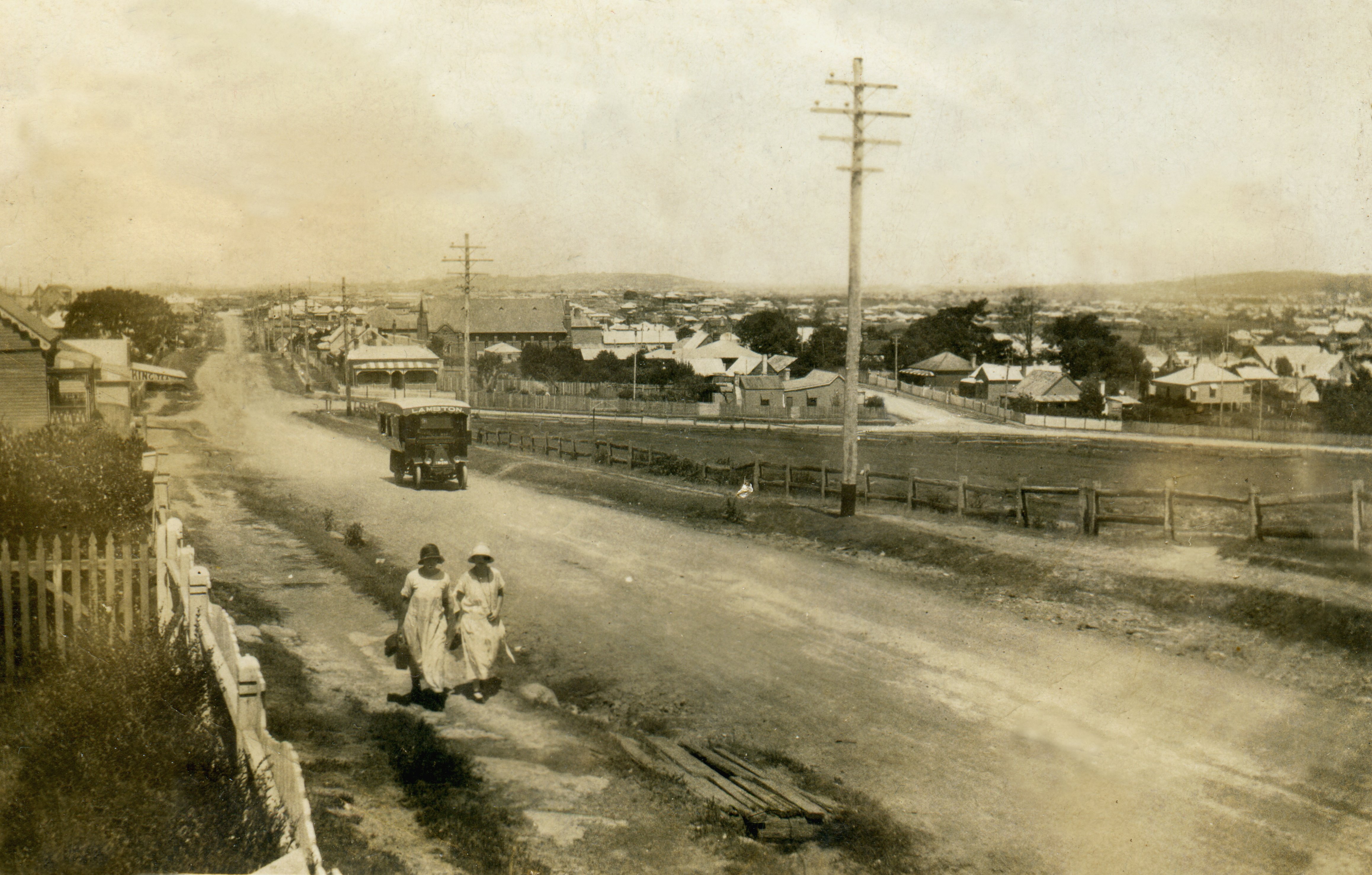
Looking east along Newcastle Road at Lambton circa 1920s. Croudace Street can be seen running off to the south in the mid-ground. Image provided by Grant Morgan and used with permission.
The photo above shows Newcastle Rd looking east towards the intersection with Dent St and Croudace St. The photo is undated but is probably from the 1920s. The abundance of names for this road has a long history – the section in the foreground of this photo was once called Hartley St, and the section beyond, to the east, was originally Young St.
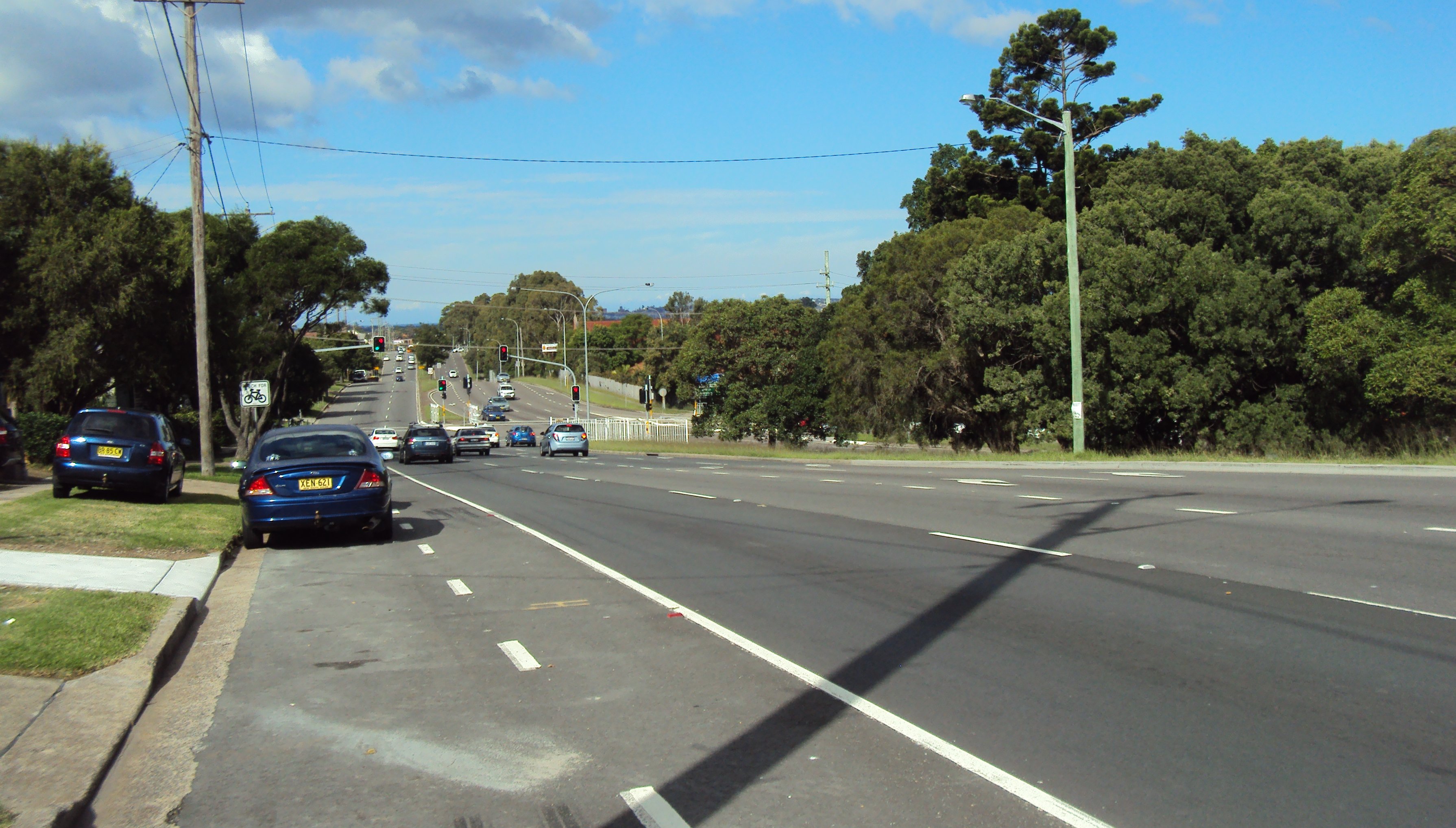
Newcastle Rd at Lambton as it appears in 2015. Note the houses fronting the westbound side of the road were demolished to make way for road widening.
“The Story of Lambton” published by Newcastle Family History Society, describes some of the saga of the building the road into town. There are a couple of details there which need clarification.
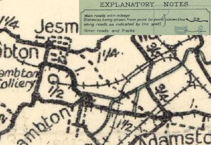
On page 42 “The Story of Lambton” states that the popular northern route was “from Lambton via Betty Bunn’s crossing [rail crossing at Griffith’s Road] to Waratah (the present day Lambton Road).” This is incorrect – the northern route that was proposed was approximately the path of present day Young Road. Thomas Croudace’s letter to the paper on 5 May 1874 describes the northern route as passing to the north of the Dog and Rat Pit and prior to 1891 Young Road was known as ‘Dog and Rat Road’. Parrott’s 1893 map shows the route across the Broadmeadow flat being slightly to the north of the eventual alignment of Young Road.
1893 map showing the route across the Broadmeadow flats as being slightly to the north of Young Rd, which was eventually built along the alignment of the water pipes.
Parrott’s 1893 map overlaid onto a 1944 aerial photograph.
The following letters to the editor on 5th May 1874 give clear details of the two proposed routes.
On page 43 “The Story of Lambton” states that “By the end of 1875 the northern road was opened but the southern route took a little longer to complete.” While this is strictly true, it wasn’t “opened” in the sense that we take it today, of completely constructed and ready for use. The “opening” of the northern route in November 1875 was merely a formal recognition by the government surveyor that the route was an official road route, the removal of some fences and the cutting of a rough track through the bush. Although the surveyor “opened” the road in November 1875, it was only “opened for public traffic” in September 1876, and it seems that the government didn’t allocate any funding to the road until 28 years later, in 1903.
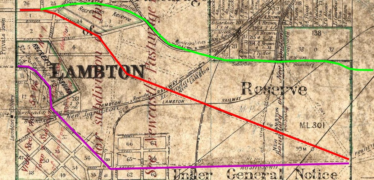
1912 map showing the “southern route’ in purple, the “northern route” in red, and the modern route in green.
Google Maps showing the “southern route’ in purple, the “northern route” in red, and the modern route in green.
This 1928 road map neatly sums up the victor and vanquished in the main road debate. The southern route via New Lambton is a bold “main road” while the Young Rd route is a dashed “other road or track”.
Portion of 1928 Craigie’s map of Newcastle, showing Young Road running across District Park.
The old battles of Young Road
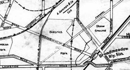
In the 1930s the Newcastle Aero Club was established and they set out to build an Aerodrome on the Broadmeadow flats. The Aero Club purchased 4.5 acres of land and leased a further 53 acres from the District Park Trust, on the northern side of the main stormwater channel. The 53 acre portion included a triangular section of land bounded by Young Rd, Turton Rd, and the stormwater channel running from Lambton.
In order to make use of this land, the Aero club constructed a deviation of Young Rd along the Lambton stormwater channel, and requested that the government close a length of Young Rd. The aerodrome and road deviation was approved by the government in August 1932.
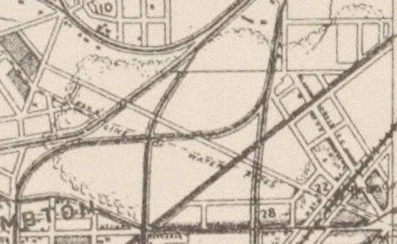
This aerial photograph of Broadmeadow on 3 September 1944 shows the Young Rd deviation.
In this map from 1960, both the original Young Rd, and the deviation along the stormwater channel are marked on the map, with dashed lines, indicating their closure.
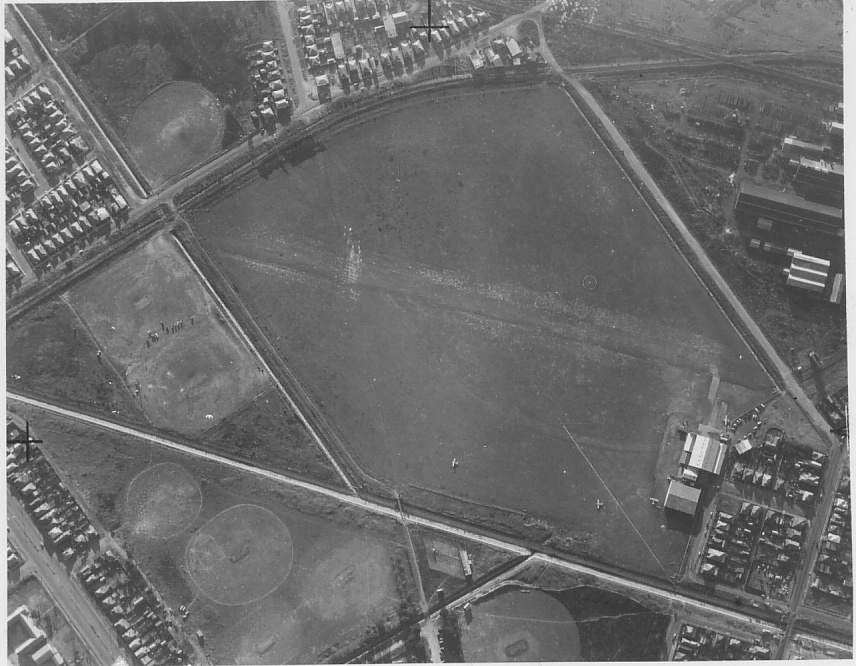
In this undated aerial photograph of Newcastle Aerodrome at Broadmeadow (present day site of Hunter Stadium) you can see still see a faint outline in the aerodrome paddock of where Young Rd used to run, and the deviation of Young Rd beside the Lambton stormwater channel.
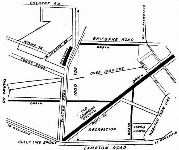
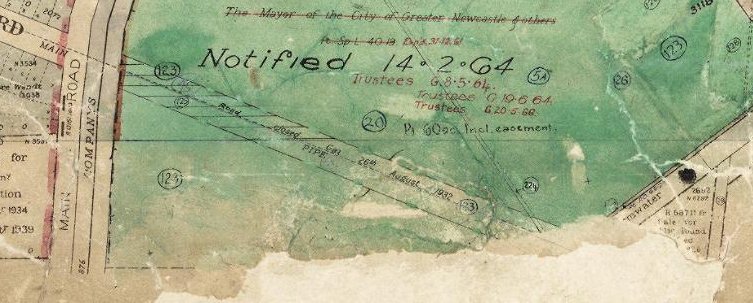
A September 1944 newspaper article on a proposed extension to the aerodrome, has an accompanying map of the area, where the deviation road alongside the Lambton stormwater channel, and the Young Rd bridge over the main stormwater channel is missing. This contradicts the 1944 aerial photo. Either the map is incomplete, or the date on the aerial photograph is wrong.
Map accompanying a September 1944 newspaper article on a proposed aerodrome extension.
When was Young Road closed?
Its not entirely clear when Young Rd over the neutral ground was finally closed, as there is contradictory evidence.
A newspaper article in December 1948 says that the bridges over the stormwater drains “had been closed for 10 years”. (1938 closure?)
Another article from September 1951 says that the “road had been closed for five and a half years.”(1946 closure?)
An aerial photograph supposedly from 1944 showing the deviation road and bridge still in place.
An article from October 1946 talks about the “disused bridges”.
My best guess is that the bridges were closed in early 1946 and that the mention in 1948 of the bridges being closed for “10 years” was a result of mis-hearing someone say the bridges had been closed for “2 years”.
Other notes
The northern route had to pass over the Broadmeadow swamp between Lambton municipality and Hamilton municipality. As this flat swampy ground was neither part of Lambton or Hamilton, it is often referred to in newspaper articles as “the neutral ground”.
"The gardens of the miners in and around Lambton present quite a pleasing
appearance ; the beautiful blossoms of the peach trees are to be seen on all sides. It is a pity we
have no road to Newcastle, for if we had one I am sure your citizens would often have a ride
or drive out here. I wish I could tell you when we shall have one."
There has been no communication received from the Lands Office as to the survey and proclamation of the main road – “the Minister, having apparently got sick of the whole matter, now refuses to answer any letters on the subject from any of the Corporations.”
Government surveyors have been in the area, but no official word yet on the surveying of the main road in a “past the old Dog-And-Rat Pit, in a direct line from Lambton to Hamilton.”
Rev Spicer Wood’s letter to the editor calling for a petition to parliament for funds for the main road. “Not long ago Mr. Sutherland was driven from Newcastle along the existing series of tops and bottoms, ruts and chasms, dignified by the name of road.”
Public meeting in Lambton calling for a petition to the government requesting the construction of a main road from Newcastle to Wallsend. The meeting ends in a near fight as arguments rage about the proposed route of the road.
Another rowdy meeting trying to get a petition up, and debating the merits of the two routes. Thomas Croudace indicates that his preferred southern route had been surveyed by Mr. Evans at his request in 1873.
Letter to the editor from Thomas Croudace, advocating the southern route via New Lambton. Again there are unambiguous details that show that the proposed northern route was via a path close the the present position of Young Rd.
Main road route between Lambton and Hamilton published in the NSW Government Gazette.
The road is described as "being that part from the western boundary of the A. A. Company's 2,000 acres, to the north-western corner of J. Weller's 2,560 acres, parishes of Newcastle and Kahibah, county of Northumberland, in the Municipalities of Lambton and Hamilton."
“The opening of the main road from Newcastle to Wallsend, is just about as far from being proceeded with as it was three years ago, when the question was first mooted.”
Deputation to Sydney to visit the government ministers. The Minister for Lands says that the northern route will be officially opened in a few days. On the other hand the Minister for Works is saying that he favours spending the promised £400 on the southern route.
The government having decided on the southern route, sends a valuer to assess the amount of compensation it will pay to Lambton Council for road works already completed.
Mr Croudace delivers to the Minister of Works "a written guarantee that the Lambton Coal Company would construct a bridge under their railway line at their own expense; also, a written promise from the New Lambton Company to subscribe £200 towards erecting a high-level bridge at the crossing of their railway."
Surveyor Evans ordered by minister to open the northern route. ‘Opening’ the road seems to be no more than knocking down a few fences and walking the route of the road. Thomas Croudace opposes the opening and tries to re-erect the fencing at his railway. [This article begins with a good summary of the saga to this point.]
Lambton Council wants to use the £90 granted to it in compensation, to instead be used to build the road over the “neutral ground”. The article also has an extraordinary criticism from the editor of the paper on his Lambton correspondent’s accuracy of reporting.
Although the northern route has been officially opened – even plans to cut a 12 foot track through the “neutral ground” have been thwarted by Mr Croudace re-erecting the fence at the Lambton company railway crossing.
Lambton council to ask the government for £600 for construction of the road over the “neutral ground”. The council also delays any further construction in Young Rd until the issue of the crossing of Lambton railway is resolved.
Banquet to celebrate the official opening of north route main road. The rejoicing was somewhat muted and has some sense of a hollow victory. There is a degree of animosity and negativity present in some of the speeches.
The southern road is being “extensively used by foot passengers and horsemen”. The road is “very fair” from Hamilton to the gully line, but between there and New Lambton is still “very swampy”.
The Minister for Works says Lambton council cannot spend the £90 in compensation for works already done to build the road over “neutral ground”. The Council therefore asks the local member to request £400 in Parliament for this purpose.
"It seems that the Lambton Council are still determined to push the North Road, and are determined to have the fences removed again. When they do commence there will be even more chopping than on the last occasion, for the Waratah Company has erected a double fence across the line of road."
Lambton council lobbying New Lambton Council and the government to get “Young Road” (formerly “Dog and Rat Road”) opened up. New Lambton council is not keen on the idea.
Recent completion of the bridges on the Young-road route, which cost about £700. "Men are now busy
forming and metalling a part of this direct route to Broadmeadow."
Lambton council still arguing for Young Rd … "Alderman Lightfoot thought that the council should make application for Young-road to be proclaimed a main road. It passed through an important centre, and would be a great convenience to a large number of people."
In a public hearing considering the extension of the aerodrome, the Land board recommends closure of a portion of Young Rd, and using a deviation road, already constructed 135 yards south.
Just as it seems Young Rd has always been in rainy weather, it is described as “almost untrafficable” and a “quagmire”. A full 56 years after it effectively lost the “main road” dispute, Lambton Council objects to the closure of Young Rd because “it might become a main road in the near future.”

 A couple of years ago I posted an article and some photos of a Douglas C47 transport aircraft that ended up in the storm water drain beside the Broadmeadow aerodrome during World War 2.
 … could that be the crashed C47 in the drain?
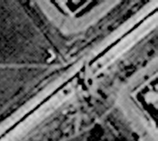 The aerial photograph has an information panel along the bottom, and in the white shape next to “RUN 5” there is some very faint writing.
 This is just three weeks after the 10th August 1944 crash of the aircraft, and confirms that it is indeed the C47 plane we can see in the aerial photograph.