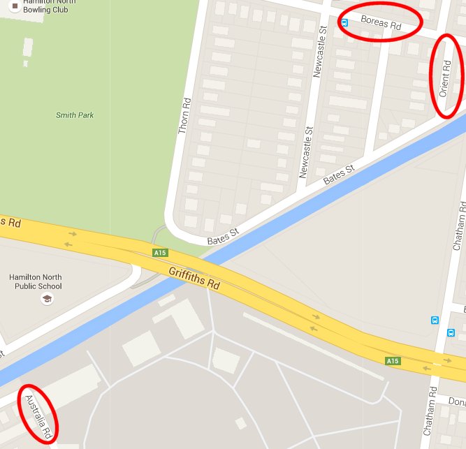
A couple of months ago in an e-mail conversation with Mark Maclean we noted that in Hamilton North and Broadmeadow there is a “Boreas St” (North) and an “Orient St” (East) and an “Australia Rd” (South). I jestingly wondered about the missing compass point, and the whereabouts of “Occident Rd” (West).
I actually did a search on Google Maps and found that the closest was an “Occident St” in Nulkaba, which interestingly has a companion “Boreas St” and “Austral St”, but is missing an “Orient St”.
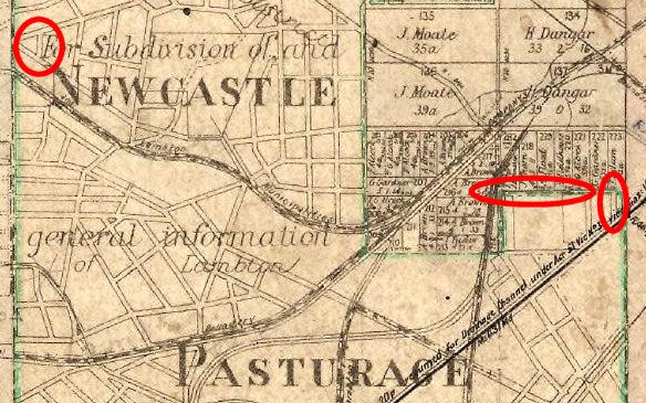
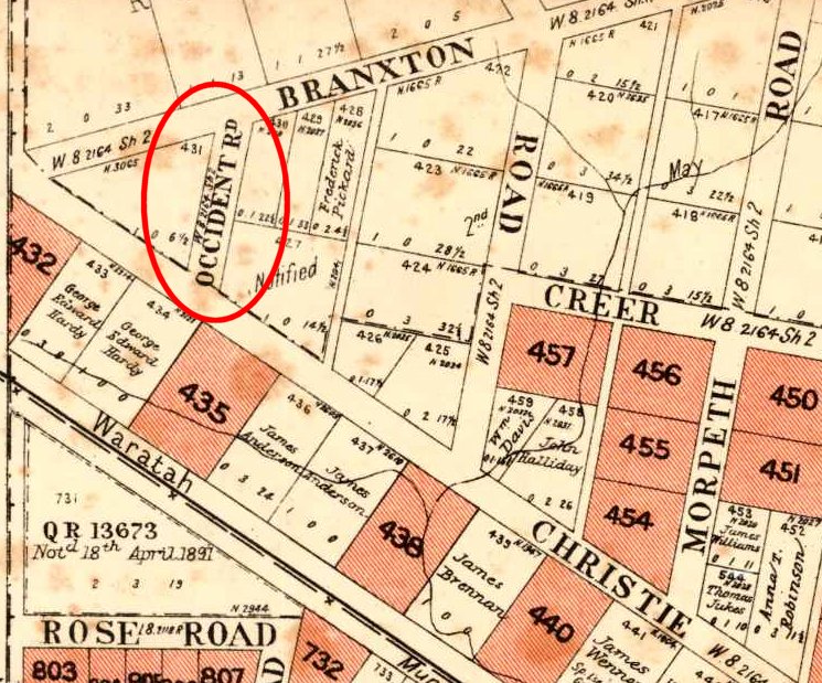
Then a few days ago when I was putting together the web page for my January 2016 article for the Lambton Local, I accidentally and serendipitously discovered on a 1906 real estate map that there was an “Occident Rd”, in neighbouring Waratah West!
This road was closed in 1910, and Christo/Christie Rd shortened.
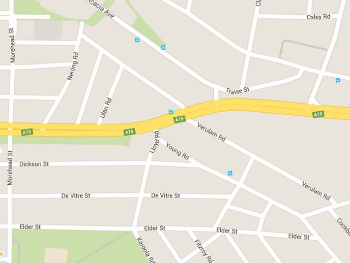
By overlaying the old map onto Google Earth you can get a sense of where Occident Rd used to be, in the area which is now part of the Acacia Avenue Reserve.
So is there any intentional connection between these streets? I have seen no direct evidence of this, but it is somewhat suggestive that when you look at a map of the Newcastle Pasturage Reserve (below) where the reserve boundary is marked in green, that Occident Rd is adjacent to the west boundary, Orient St is adjacent to the east boundary and Boreas St is on a north boundary of the reserve. Coincidence or not? Unfortunately Australia St is not near any boundary.
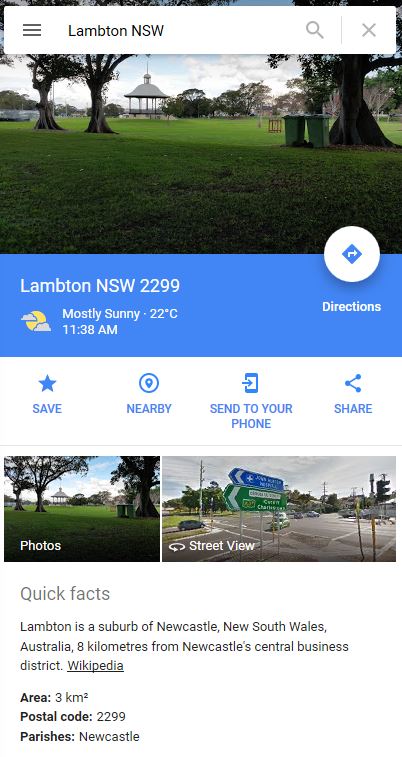
In Google Maps, if you search for a suburb name, as well as the map result the page will show a photo from the suburb, which presumably is auto-selected by the Google-fairy-bots according to some secret algorithm. Mostly this works. For example for “Lambton NSW” you get a nice photo of Lambton Park and the rotunda.
But search for “Jewells NSW” and you get … a burnt out car and assorted rubbish on a beach track. The Google-fairy-bots might need a bit of help on this one.
Update 23 Jan 2016
Searching for Jewells now shows someone’s driveway. A step up from a burnt out wreck, but not exactly showcasing the suburb.
My latest article for the Lambton Local is out, this month exploring the topic of old maps. In the course of researching and writing this article I discovered amongst other things why this building has a kink in it, and the location of Occident Road, the counterpart to Orient Road Hamilton North.
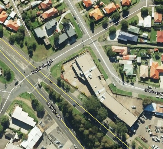
I love old maps. They are like a time machine allowing us glimpses of our past environment, and occasionally it is surprising to discover that something long gone has affected the shape of our present urban landscape. A good example is the area where Acacia Ave meets Griffiths Rd today.
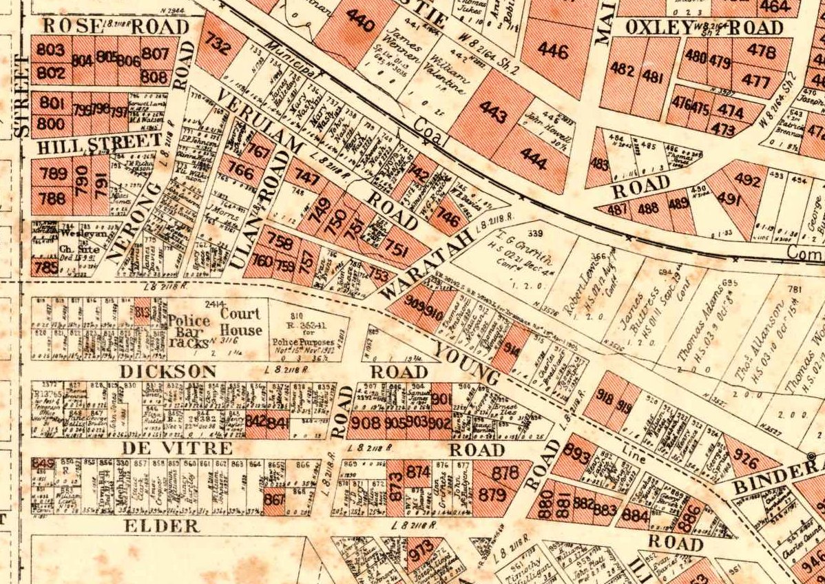
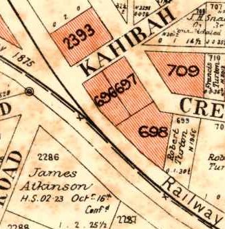
The map above is from a 1906 poster advertising land for sale (the shaded areas) and shows that the Waratah Coal Company railway once ran along the present day Acacia Ave and a section of present day Griffiths Rd. What is now Lambton Rd and Traise St, was originally Waratah Rd which intersected the colliery railway at a spot known as “Betty Bunn’s Crossing”. The map reveals other interesting details such as the location of the Lambton Courthouse on Dickson St, and the names of various land owners along the rail line, such as T.G. Griffith.
But as with much historical research, old maps can pose as many questions as they answer. Lloyd Rd is shown in a dotted outline extending across Lambton Park. Was this a road that once was and is no more, or a road that once was meant to be, but never was? Why was the railway intersection known as Betty Bunn’s Crossing? Was Griffiths Rd named after T.G. Griffith?
For all these questions, there is one answer that I find most satisfying. On the corner of Griffiths Rd and Kahibah Rd there is a building with a bend, because the block of land is bent, because it was once hemmed in by the railway. I worked in that building for 17 years, never once realising that the funny little kink in the middle owed its existence to a colliery railway that was removed over a hundred years ago. The past does indeed cast long shadows into curious places in the present.
The article above was first published in the January 2016 edition of the Lambton Local.
Further information
The 1906 map of Lambton is from a real estate poster in the University of Newcastle Cultural Collections photo archive on Flickr. There are over 800 other real estate posters from this era in their collection, and to assist in locating items from particular areas, using Google Maps I have put together a visual index to the historical real estate maps.
Although the 1906 map shows the Waratah Colliery railway line still in place, it seems that by this time it was no longer in use. Back in November 1904 the Mayor of Lambton “suggested that the Waratah Coal Company be asked to remove a length or two of rails where the old quarry rail-way crossed the Waratah-road.” Waratah council was also asked in December 1904 to cooperate with Lambton council in this matter. The rail corridor was officially resumed by the Government in the Newcastle Pasturage Reserve (Railways) Resumption Act of 1915.
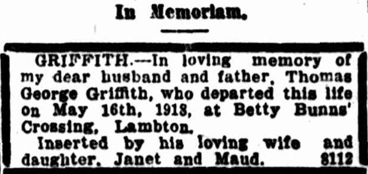
Thomas George Griffith of Betty Bunns Crossing died 16 May 1918, aged 73.
The 1906 map also shows a number of other interesting things.
The road on the south-western border of Lambton Park (now Howe Street) was once Croudace Street.
Christo Road was once Christie Road.
There was at one time an Occident Road, running off Christie road. This is the missing compass point street name to Boreas St, Orient St, and Australia Rd in nearby Broadmeadow and Hamilton North.
The Question of Lloyd Road
In the article I mention that the 1906 map shows Lloyd Road as a dotted outline crossing Lambton Park, and ask whether this a road that once existed and was removed, or a road that was planned but never built?
Although there is no conclusive evidence, my own view is that the section of Lloyd Rd across Lambton Park was never built. My reasons are …
Of all the old maps I have of this area, about half show this section of road, and about half omit it. Of those that show it, most of them show it in a dotted/dashed outline.
None of the old photographs I have seen of Lambton Park show any evidence that a road was once there.
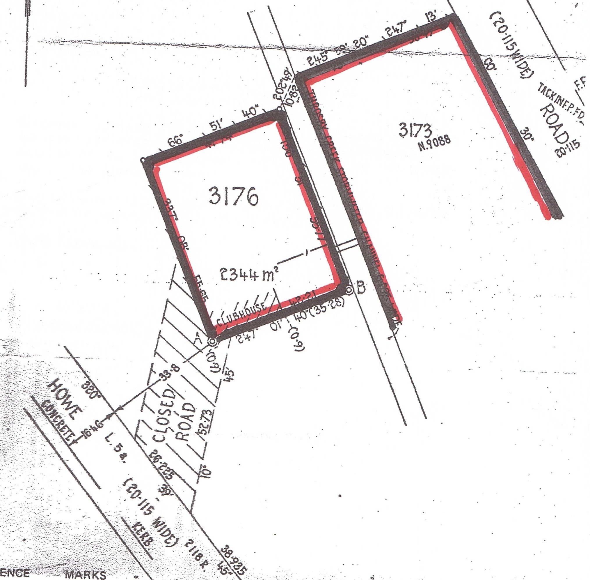
In the Lambton Municipal Council meeting in September 1886, there is a reference to this section of road in a letter to the district surveyor …
To District Surveyor Allworth, respecting Reserve, pointing out that the surveyors were at work, and that the council had been informed that instructions had been given, to retain Lloyd-street as shown through the reserve on plan. The council held that this street was not required, and that it would spoil the appearance of the Reserve by cutting it into two portions and occupying a considerable amount of surface.
Although the wording is somewhat ambiguous, two things suggest to me that Lloyd Rd through the park was not a reality on the ground. Firstly the instruction to retain Lloyd Street as shown “on plan“. And secondly, the use of the future tense in saying that Lloyd St “would spoil the appearance”.
Another indirect reasoning that makes me think Lloyd Rd never ran across the park is by asking the question ‘Who built and paid for the road if it existed?’ Prior to its dedication as a park in 1887 this land was part of the Newcastle Pasturage Reserve (or Commonage), not part of Lambton Municipality. Lambton council was having enough trouble building and maintaining roads they were responsible for, so I cannot imagine the council would have built a road on land they weren’t responsible for. Thomas Croudace in his nomination speech for New Lambton Council in 1889 even says that for a council “it would be illegal to form and make streets on that land.” As for the State Government, the consistent picture at this time is that they are all talk and no action when it comes to doing anything with the reserve. If it took them over ten years just to do the paperwork in gazetting Lambton Park, it is inconceivable that they would have spent any effort or money in building a road there.
Plan of Lambton Women’s Bowling Club in Lambton Park, with Lloyd Rd shown in crosshatch, marked “Closed Road”
I was using Google Maps tonight and was getting frustrated at how broken it seemed when searching for directions – it wasn’t showing me multiple routes, or route options like avoiding tolls, or giving me the ability to change the route by dragging points on the path – features that were there previously.
It turns out that it wasn’t broken, but that somehow I’d got into “Lite mode”. Clicking on the lightning bolt icon in the bottom right corner soon restored sanity to my mapping searches.
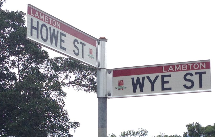
The most curious address in Newcastle – the corner of Howe and Wye (“How” and “Why”) streets.
Thanks to Simon, who pointed this out to me several decades ago. Where are you now Simon?
When it comes to mapping our cities, Google Maps and Apple Maps are streets apart. No map is ever perfect, and the difference between Google and Apple is starkly emphasised when it comes to correcting errors. Here’s what happens …
Google Maps
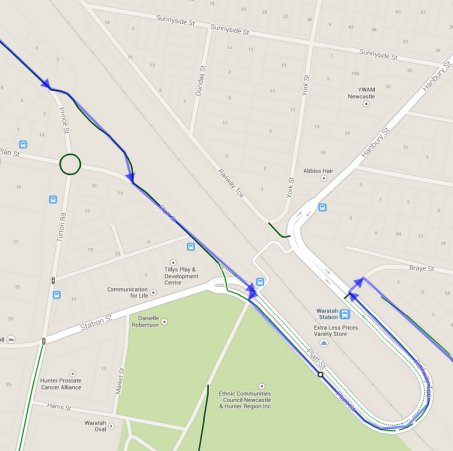
I notice that in getting directions for cycling from North Lambton to Wickham that the suggested route doesn’t take into account recently constructed cycle paths around Waratah Station.
I report the problem to Google Maps.
One minute later I receive an e-mail acknowledgement that the report has been received.
Four days later I receive an e-mail saying that my report has been reviewed and accepted, and that a correction to the maps will be made.
Three months later I receive an e-mail saying that the correction is now live on Google maps.
Now three months is fairly glacial in the digital age, but nevertheless, it was a very straightforward matter of problem observed, problem reported, problem corrected.
Apple Maps
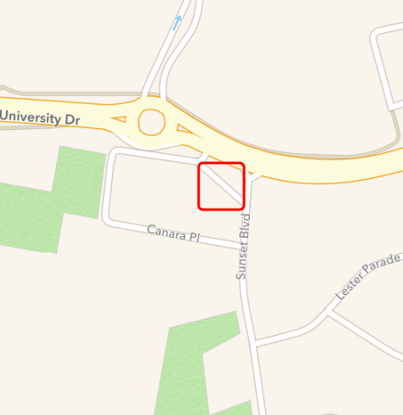
Now here’s what happens with Apple Maps when you report a problem, like this non-existent section of street in North Lambton …
I report the problem to Apple Maps.
Nothing.
Still Nothing.
Three months later I report the problem again.
Nothing again.
Nothing, not even an acknowledgement the report has been received.
Two years later, still nothing, not even the sound of crickets chirping, a complete and utter vacuum. Just as well for Apple that they can’t hear people scream in a vacuum.
Mark Maclean charitably suggests that Apple is engaging in a new cartographic discipline called ‘speculative topography’ – I have many other suggested names for Apple’s mapping endeavours, none of them as charitable as Mark’s.
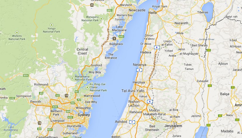
In church at the moment we are working through John’s gospel, and a couple of times Arthur has shown us on a map Jesus’ movements around Judea and Galilee, and made the observation that the distance between Galilee and Jerusalem, is pretty similar to the distance between Newcastle and Sydney – a journey that we Novocastrians are very familiar with. Just to see this visually, I’ve used Google Maps and a bit of cut-and-paste to put the east coast of NSW next to Israel – and the similarity in distances is indeed strikingly close.

 I actually did a search on Google Maps and found that the closest was an “Occident St” in Nulkaba, which interestingly has a companion “Boreas St” and “Austral St”, but is missing an “Orient St”.
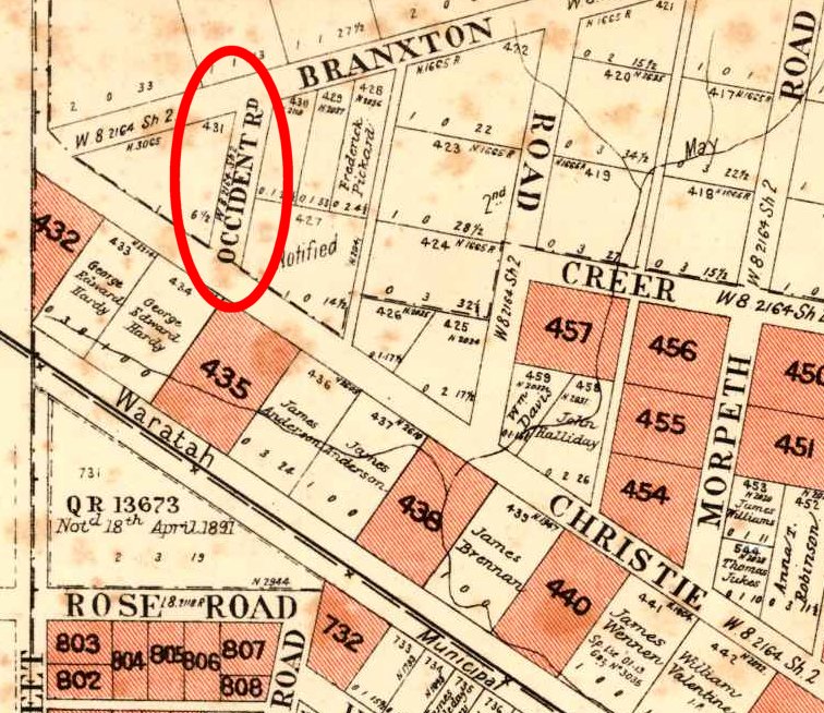 This road was closed in 1910, and Christo/Christie Rd shortened.
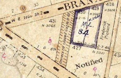 By overlaying the old map onto Google Earth you can get a sense of where Occident Rd used to be, in the area which is now part of the Acacia Avenue Reserve.
 So is there any intentional connection between these streets? I have seen no direct evidence of this, but it is somewhat suggestive that when you look at a map of the Newcastle Pasturage Reserve (below) where the reserve boundary is marked in green, that Occident Rd is adjacent to the west boundary, Orient St is adjacent to the east boundary and Boreas St is on a north boundary of the reserve. Coincidence or not? Unfortunately Australia St is not near any boundary.